Browse Listings
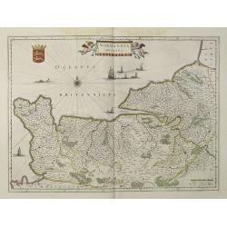
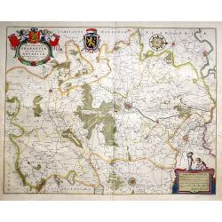
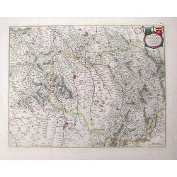
Normandia Ducatus.
Very detailed map of Normandy centered on Caen and Rouen. Also showing Cherbourg, Avranches, Bayeux, Cabourg, Honfleur, Le Havre, Etretat, Fecamp. St Malo and Mont Saint ...
Date: Amsterdam, 1640
Selling price: ????
Please login to see price!
Sold
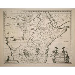
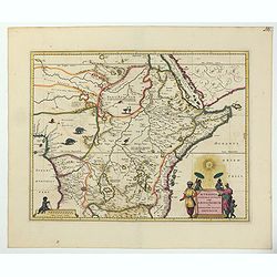
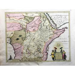
Aethiopia Superior vel Interior vulgo Abissinorum.
An attractive map of the Eastern African and the fictitious kingdom of Prester John. The map shows a major section of central and eastern Africa including Mozambique nort...
Date: Amsterdam, 1640
Selling price: ????
Please login to see price!
Sold in 2009
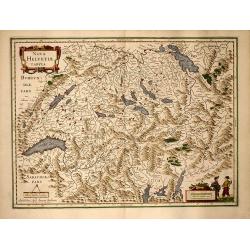
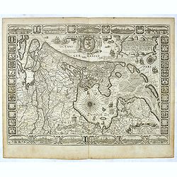
Nova Helvetiae Tabula
Beautiful colored mid 17th century copper engraved map of Switzerland by J. Janssonius. With two cartouche and a mileage scale. Covering complete Switzerland with the Lak...
Date: Amsterdam, 1640
Selling price: ????
Please login to see price!
Sold in 2009

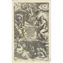
Historischer Chronicken Continuation, oder, Warhafftre Beschreibung . . .
Beautiful German baroque allegorical title page from and Merian's Historischer Chronicken Continuation, oder Warhafftre Beschreibung. Frankreich.
Date: Frankfurt, ca. 1640
Selling price: ????
Please login to see price!
Sold in 2009
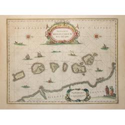
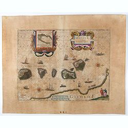
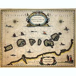
Insularum Moluccarum Nova descriptio.
The small spice islands off the west coast of the island of Halmahera in the eastern part of the archipelago. With an imposing title cartouche, together with finely drawn...
Date: Amsterdam, 1640
Selling price: ????
Please login to see price!
Sold in 2009
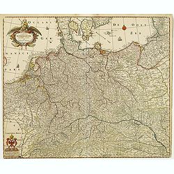
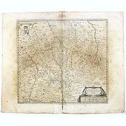
Silesiae Ducatus . . .
Centered on Breslau. Including the towns of Dresden, Cracow, Prague, Olmitz, etc.Decorative map prepared by Jonas Scultetus, a Silesian cartographer (1603-1664).French te...
Date: Amsterdam, 1640
Selling price: ????
Please login to see price!
Sold in 2010
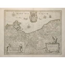
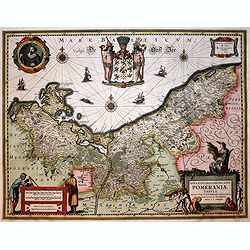
Pomeraniae ducatus Tabula.
Finely engraved map of Pomerania, geographical region today divided between northern Poland and Germany on the south coasts of the Baltic Sea. With decorative title carto...
Date: Amsterdam, 1640
Selling price: ????
Please login to see price!
Sold in 2009
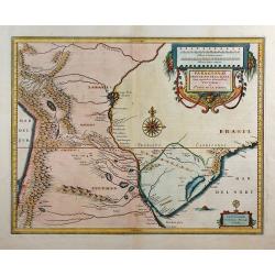
Paraguayo Prov. De Rio De La Plata cum regionibus..
This is an early map showing this northern Patagonia territory. Also showing Rio de Janeiro, Sao Paolo, Santa Cruz of Bolivia, Paraguay, Uruguay, Buenos Ayres, Chili and ...
Date: Amsterdam, 1640
Selling price: ????
Please login to see price!
Sold in 2009
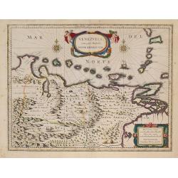
Venezuela, cum parte Australi novae Andalusiae.
A finely engraved, decorative map. The islands Trinidad, Margarita, Aruba and Curaçao are shown as well. With decorative title cartouche.
Date: Amsterdam, 1640
Selling price: ????
Please login to see price!
Sold in 2009
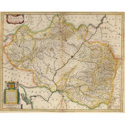
Novissima Arragoniae ?
Shows cities of Saragossa and Pamplona. Dedication to a list of worthies, deputies of the king in Aragon by Henricus Hondius.
Date: Amsterdam, 1640
Selling price: ????
Please login to see price!
Sold in 2009
Abissinorum sive Pretiosi Ioannis Imperiu
Hand colored map of Central Africa by G. Mercator. With two beautiful colored cartouche and one inset map of the Congo. Showing the Kingdom of Prester John in central Afr...
Date: Amsterdam, 1640
Selling price: ????
Please login to see price!
Sold in 2013
Fezzae et Marocchi regna Africae celeberrima
Old colored map of Morocco by W. Blaeu. With the Strait of Gibraltar, several sailing ships and a large figural cartouche. The map is based on Ortelius map of 1570. From ...
Date: Amsterdam, 1640
Selling price: ????
Please login to see price!
Sold in 2009
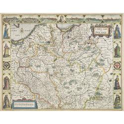
A Newe mape of Poland Done into English by I.Speede.
A wonderful map of Poland. Incorporated into Speed's 'Prospect Of The Most Famous Parts Of The World.' Includes birds-eye views of Cracow, Dantzick, Posna, Crossen, Sando...
Date: London, 1640
Selling price: ????
Please login to see price!
Sold in 2017
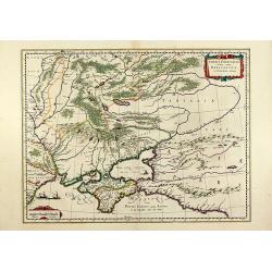
Taurica Chersonesus, Nostra aetate Przecopsca et Gazara dicitur.
Old colored engraved map of the Ukraine with the Crimea peninsula by W. Blaeu. With two colored cartouches and three sailing ships. From "Atlas Major" around 16...
Date: Amsterdam, 1640
Selling price: ????
Please login to see price!
Sold in 2011
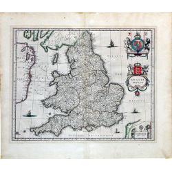
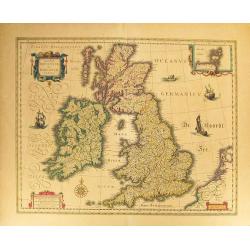
Anglia Regnum.
A striking map of Great Britain with two finely-engraved coats of arms (Great Britain and Ireland).
Date: Amsterdam, ca. 1640
Selling price: ????
Please login to see price!
Sold in 2010
Historischer Chronicken Continuation, oder, Warhafftre Beschreibung . . .
Beautiful German baroque allegorical title page from Merian's Historischer Chronicken Continuation, oder Warhaffte Beschreibung. . . ..
Date: Frankfurt, ca. 1640
Selling price: ????
Please login to see price!
Sold in 2010
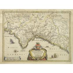
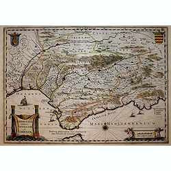
Valentia regnum Contestani, Ptol. Edentani, Plin.
Fine map of the Spanish province of Valencia, with large title cartouche and Dutch vessels offshore.
Date: Amsterdam, 1640
Selling price: ????
Please login to see price!
Sold in 2023
![Natolia, quae olim Asia minor. [shows Cyprus]](/uploads/cache/29288-250x250.jpg)
Natolia, quae olim Asia minor. [shows Cyprus]
A finely designed map from the great Blaeu family of Amsterdam. Decorative map of Asia Minor, showing Cyprus and the Islands in the Aegean. Embellished with a banner cart...
Date: Amsterdam, 1640
Selling price: ????
Please login to see price!
Sold in 2010
Nova famigerabilis insulae ac ducatus Rugiae descriptio.
Both side borders are filled with coat of arms of the island's leading families. Including two compass roses, sailing ships, sea monsters and a large coat of arms in the ...
Date: Amsterdam, c.1640
Selling price: ????
Please login to see price!
Sold in 2011
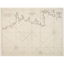
De Custen van Engeland en Schotlandt tusschen Tinbij en de Eijlanden van Orcanesse.
Very rare of the coasts of Scotland, with Aberdeen, from The New Fierie Sea-Colomne, published in 1640 by Jacob Aertz. Colom. .
Date: Amsterdam, 1640
Selling price: ????
Please login to see price!
Sold in 2010
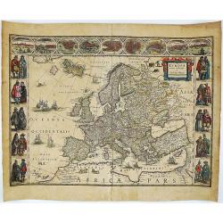
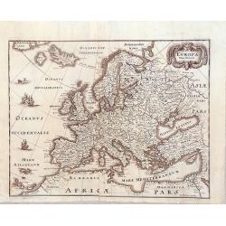
Europa recens descripta a Guilielmo Blaeuw.
Blaeu’s striking map of Europe, framed on both sides by five costumed figures. Left border: Angli, Galli, Belgi, Castiliani, Venetiani. Right border: Germani, Hungari, ...
Date: Amsterdam, 1640
Selling price: ????
Please login to see price!
Sold in 2018
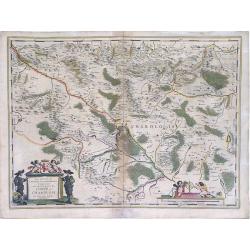
Les environs de L'Estang de Longpendv, Comprenant une grande partie du Comte de Charolois.
Beautiful map showing the lands of the Duke of Charolais in the region of France west of Chalon-sur-Saône, between Dijon and Lyon in France, published by the Blaeu firm....
Date: Amsterdam, c.1640
Selling price: ????
Please login to see price!
Sold in 2010
Ducatus Silesiae Glogani Vera Delineatio . . .
Decorative regional map of Silesia, centered on Breslau. Extends from Cracow to Glogau and Gorlitz. Two cartouches, each with a large coat of arms. French text on verso.
Date: Amsterdam, 1640
Selling price: ????
Please login to see price!
Sold in 2015
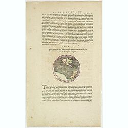
Circumferentia terrae continet miliaria germanica 5400, italica vero 21600.
Text page from "Introduction" of a Blaeu Atlas, Chapter VII. "De la division du Globe en 360 parties: du circuit de la terre, de sa longeur & largeur.T...
Date: Amsterdam, c.1640
Selling price: ????
Please login to see price!
Sold in 2014
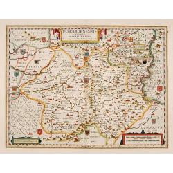
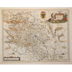
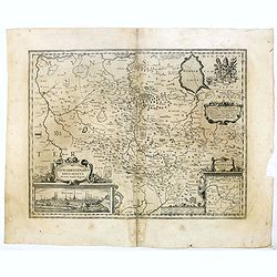
Paderbornensis Episscopatus Descriptio Nova.
Detailed map centered on Paderborn. Prepared by Joannes Michael Gigas (1580-1650+), a doctor, mathematician, and geographer who also made maps of Osnabrug, Westphalia, M�...
Date: Amsterdam, 1640
Selling price: ????
Please login to see price!
Sold in 2019
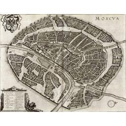
Moscva.
Superb bird's-eye plan of Moscow from Merians "Neuwe Archontologia cosmica". The very detailed map shows many buildings, streets, bridges, and more. With the ...
Date: Frankfurt, c1640
Selling price: ????
Please login to see price!
Sold in 2011
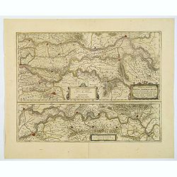
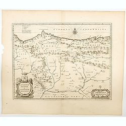
Descriptio fluminum Rheni, Vahalis et Mosae. . .
A fine map of central Netherlands where three great rivers flow to within but a few kilometres of each below Wesel. (The Rhine, the Waal and the Meuse Rivers). The scale ...
Date: Amsterdam, ca 1640
Selling price: ????
Please login to see price!
Sold in 2019
Holsatia.
From the English edition of the miniature Mercator/Hondius atlas, published in Amsterdam in the first half of the seventeenth century. It shows the region of Holstein, si...
Date: Amsterdam, ca 1640
Selling price: ????
Please login to see price!
Sold in 2021
Nova Alemanniae sive Sueviae Superioris Tabula.
A German regional map with west orientated at the top of the map, showing the area between Lech & Danube, with Lake Constance (Boden See) and the Allgau. A detailed m...
Date: Amsterdam, ca 1640
Selling price: ????
Please login to see price!
Sold in 2021
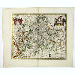
Wirtenberg Ducatus.
A regional German map of Baden-Wurttemberg, engraved by Mercator and Hondius for the Janssonius atlas of 1638. Covers Offenburg, Sigmarigen, Ulm, Heidelberg, and is cente...
Date: Amsterdam, ca 1640
Selling price: ????
Please login to see price!
Sold in 2020
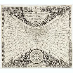
N°4. Horologium Horizontale ubi axis mundanus supra horizontem extollitur grandus XLVIIII. Scrupula XXIIII.
This beautiful engraving is a horological diagram with at bottom a 32-point wind rose and signed underneath "Franciscus Ritter N fac:".Remarkable for the elabor...
Date: Nuremberg 1640
Selling price: ????
Please login to see price!
Sold in 2020
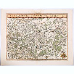
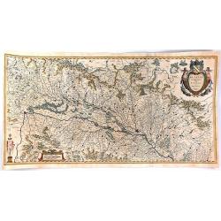
Lotharingia Ducatus vulgo Lorraine.
A very detailed map for his time centered on Nancy, Bayon and Metz, and including the river valleys of the Sar and Moselle. In the lower right-hand corner of the map is a...
Date: Amsterdam, ca 1640
Selling price: ????
Please login to see price!
Sold in 2021
Holsatia.
From the English edition of the miniature Mercator/Hondius atlas, published in Amsterdam in the first half of the seventeenth century. It shows the region of Holstein, si...
Date: Amsterdam, ca 1640
Selling price: ????
Please login to see price!
Sold in 2020
Moluccae Insulae Celeberrimae.
This plate was originally engraved in the 1620, and published as a loose-sheet by Jodocus Hondius II. At his death in August 1629 this map was, among 39 other copper plat...
Date: Amsterdam, 1640
Selling price: ????
Please login to see price!
Sold in 2020
![Carte de L'Afrique Corrigee, et augmentee dessus toutes les aultres cy devant faictes par P. Bertius 1640.[Tavernier]](/uploads/cache/84448-250x250.jpg)
Carte de L'Afrique Corrigee, et augmentee dessus toutes les aultres cy devant faictes par P. Bertius 1640.[Tavernier]
Scarce separately published map of Africa, first published by Melchior Tavernier in Paris in 1627.Bertius's map of Africa is one of the earliest maps of Africa engraved i...
Date: Paris, 1640
Selling price: ????
Please login to see price!
Sold in 2020
TABULA MAGELLANICA qua Tierra del Fuego, cum. . .
Blaeu’s influential Map of Tierra del Fuego showing the Important Strait of Le Maire. A fine example of Willem Janszoon Blaeu's map of the Straits of Magellan and Tierr...
Date: Amsterdam, ca 1640
Selling price: ????
Please login to see price!
Sold in 2020
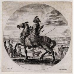
A colored man on horseback.
Stefano Della Bella (1610-1664) originated from Florence and was later active as a graphic artist in Paris. He produced a wide variety of prints, with all kinds of subjec...
Date: Paris, ca. 1640
Selling price: ????
Please login to see price!
Sold in 2021
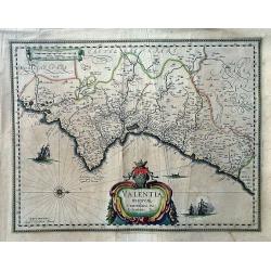
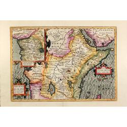
Valentia Regnum; Contestani, Ptol. Edentani, Plin.
A large, very decorative map of Valencia depicting the area from the Cenia River to St. Gines and inland to Murcia and Teruel. The map has many place names with pictorial...
Date: Amsterdam, 1640
Selling price: ????
Please login to see price!
Sold in 2022
Aethiopia Superior vel Interior vulgo Abissinorum.
An attractive map of the Eastern African and the fictitious kingdom of Prester John. The map shows a major section of central and eastern Africa including Mozambique nort...
Date: Amsterdam, ca 1640
Selling price: ????
Please login to see price!
Sold in 2022
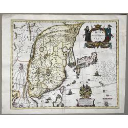
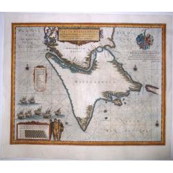
China Veteribus Sinarum Regio nunc Incolis Tame dicta
Willem and Johan Blaeu's map of China, with Japan and Korea. With the Great Wall forming the northern boundary of China and the fictitious lake Chiamay.Title in a cartouc...
Date: Amsterdam, ca. 1640
Selling price: ????
Please login to see price!
Sold in 2023
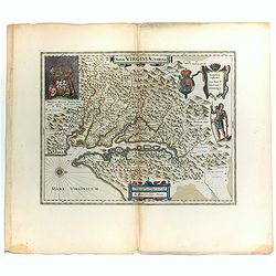
Nova Virginiae Tabula.
Blaeu's beautiful map of Virginia, Maryland and the Chesapeake Bay region on North America's eastern seaboard. It shows the discoveries in the area as detailed by John Sm...
Date: Amsterdam, ca 1640
Selling price: ????
Please login to see price!
Sold in 2022
-250x250.jpg)
Antiquorum Galliae Episcopatuum...
Rare map of ancient France, including Switzerland and the Low Countries. With a large decorative title cartouche. Includes a large inset map of the British Isles.
Date: Paris, 1640
Selling price: ????
Please login to see price!
Sold in 2023

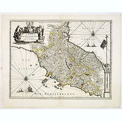
Territorio Perugino
Map of the Perugino region of Umbria, Italy; in the canter its capital Perugia with Lake Trasimeno. Nice cartouche at bottom right with a papal coat-of-arms, a tiara and ...
Date: Amsterdam, 1640
Selling price: ????
Please login to see price!
Sold in 2022
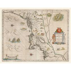
Nova Belgica Et Anglia Nova
An important and early colonial era map of the Dutch and English colonies of northeast America by the renowned 17th century map maker, Willem Janszoon Blaeu. The map is d...
Date: Amsterdam, 1640
Selling price: ????
Please login to see price!
Sold in 2023
Legionis Regnum et Asturiarum Principatus.
Blaeu's highly decorative map of the Spanish northwestern Provinces of Asturias, Castile and Léon, including the towns of Oviedo, Braganza in Portugal, Laredo, Burgos, ...
Date: Amsterdam, ca 1640
Selling price: ????
Please login to see price!
Sold in 2023
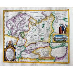
Aethiopia Superior vel Interior vulgo Abissinorum...
Offered is a large, decorative, attractive map of Eastern African and the fictitious kingdom of Prester John. The map shows a major section of central and eastern Africa,...
Date: Amsterdam, 1640
Selling price: ????
Please login to see price!
Sold in 2023
Magnae Britanniae et Hiberniae Tabula.
First issued in 1630 with vignette borders depicting costumes and towns; however, that state only appeared that year after which the borders were cropped from the plate, ...
Date: Amsterdam, [1631] - 1640
Selling price: ????
Please login to see price!
Sold in 2012
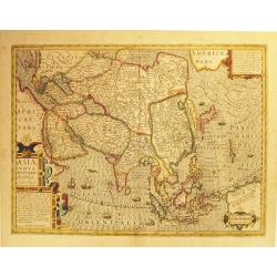
Asia Nova Descriptio.
A very fine and decorative example of early seventeenth century map engraving as practiced in The Netherlands. Several sources appear to have been used in the compilation...
Date: Amsterdam, 1606 -1640
Selling price: ????
Please login to see price!
Sold in 2012
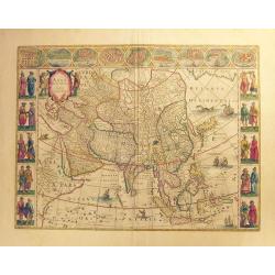
Asia noviter delineata.
Superb engraved map of Asia with Latin text on verso. This magnificent “cornerstone” map is a fine example of the famous “carte-a-figures” maps created by the Bla...
Date: Amsterdam, ca 1640
Selling price: ????
Please login to see price!
Sold in 2012
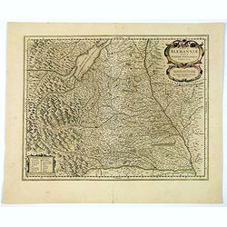
Tabula Germaniae emendata recens. . .
Uncommon map published by Claes Jansz. Visscher covering the Low Countries, Germany, Poland, Switzerland and Austria. Engraved by A. van den Broeck with his signature low...
Date: Amsterdam, 1640
Selling price: ????
Please login to see price!
Sold in 2017
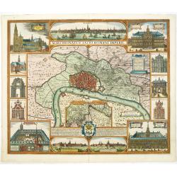
Marchionatus sacri Romani imperii.
Decorative town-plan of Antwerp. The east is at the top: at upper right two farmers carrying the heraldic shield of Antwerp. Plan and surroundings of Antwerp and at botto...
Date: Amsterdam, 1640
Selling price: ????
Please login to see price!
Sold in 2016
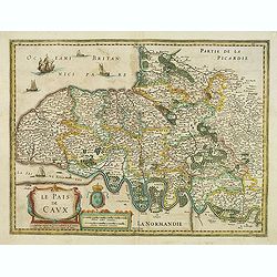
Le Pais de Caux.
Detailed map of Normandy. Map centered on Rouen, and shows Honfleur, Le Havre, St Vallery, Dieppe. . .Embellished with a beautiful cartouche, and a sailing ship.No text o...
Date: Amsterdam/ Paris, 1640
Selling price: ????
Please login to see price!
Sold
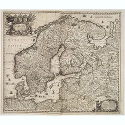
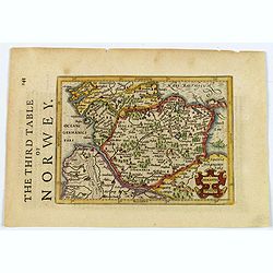
Sueciae, Norvegiae et Daniae Nova Tabula.
Signed lower right. A decorative map of the whole of Scandinavia with a large title cartouche and a decorative scale cartouche, and many ships in the seas and little figu...
Date: Amsterdam, 1640
Selling price: ????
Please login to see price!
Sold in 2020
Carte de l'Estat du Pape et du Duché de toscane.
Early imprint of this fine map of Tuscany and the Papal States, marking Rome, Pisa, Bologna, Ravenna, Perugia, including the island of Elbe. With decorative cartouches fo...
Date: Paris, 1640
Selling price: ????
Please login to see price!
Sold in 2012
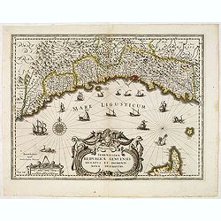
.Serenissimae Reipublicae Genuensis Ducatus et Dominii. . .
Includes the coast of the Riviera from Nice to La Spezia. A most decorative map with impressive cartouche and extensive shipping. Engraved by D.Gryp.No text on verso. Fro...
Date: Paris / Amsterdam, ca.1640
Selling price: ????
Please login to see price!
Sold in 2016
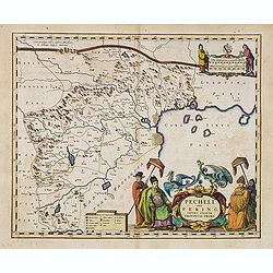
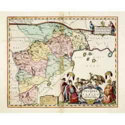
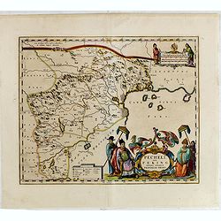
Pecheli sive Peking imperii sinarum provincia prima.
The map of the province of Peking from Joan Blaeu's Novus Atlas Sinensis , the first atlas of china with maps by the hand of the Italian Jesuit Martino Martini. A beautif...
Date: Amsterdam, 1640
Selling price: ????
Please login to see price!
Sold in 2013
Episcop Ultraiectinus, Auct. Balthazaro Florentio a Berkenrode.
Highly detailed copper engraved map featuring the area around the city of Utrecht. This map gives several details concerning rivers, canals, cities and villages. This map...
Date: Amsterdam, 1628 /1640
Selling price: ????
Please login to see price!
Sold in 2014
Europa nova delineatio.
Based on Blaeu's Europa recens descripta, this map extends to Iceland, the mythical Frisland, and the coast of Greenland. A decorative cartouche, sailing ships and a sea ...
Date: Frankfurt, 1640
Selling price: ????
Please login to see price!
Sold in 2015
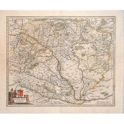
Hungaria Regnum.
Nice map of the region of Hungary by the Blaeu family. Budapest is in the center of this map. It covers most of present day Hungary, but also includes part of Austria. Ni...
Date: Amsterdam, 1640
Selling price: ????
Please login to see price!
Sold in 2014
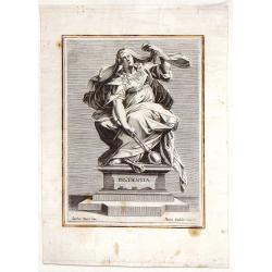
Prudentia.
Fine copper engraving by Marco Sadeler entitiled "Prudentia". From a painting by Jacopo Zucchi. The Sadeler family were the largest, and probably the most succ...
Date: Venice, c1640
Selling price: ????
Please login to see price!
Sold in 2014
Pecheli sive Peking imperii sinarum provincia prima.
The map of the province of Peking from Joan Blaeu's Novus Atlas Sinensis , the first atlas of china with maps by the hand of the Italian Jesuit Martino Martini. A beautif...
Date: Amsterdam, 1640
Selling price: ????
Please login to see price!
Sold in 2013
![[Title page] Le Theatre du Monde ou Nouvel Atlas. . .](/uploads/cache/02124-250x250.jpg)
[Title page] Le Theatre du Monde ou Nouvel Atlas. . .
Architectural frontage with the title and imprint printed on paste-on slips.With manuscript ex libris "Caminade".
Date: Amsterdam, 1640
Selling price: ????
Please login to see price!
Sold in 2019
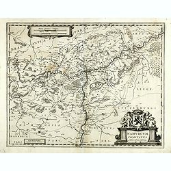
Namurcum comitatus.
Very rare map of the province Namen by Cornelis Danckerts. Depicting the region around the city of Namen/Namur based on the once-secret map of Jacques Surhon (ca. 1555). ...
Date: Amsterdam / Paris, ca. 1640
Selling price: ????
Please login to see price!
Sold in 2022
Pecheli sive Peking imperii sinarum provincia prima.
The map of the province of Peking from Joan Blaeu's Novus Atlas Sinensis , the first atlas of china with maps by the hand of the Italian Jesuit Martino Martini. A beautif...
Date: Amsterdam, 1640
Selling price: ????
Please login to see price!
Sold in 2015
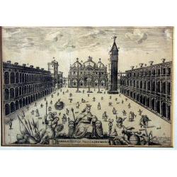
La maravigliosa piazza di S. Marco.
Very rare view of Piazza San Marco from Stefano Scolari, circa 1640. Together with the second view offered also here appears rarely on the international market.
Date: Venice, circa 1640
Selling price: ????
Please login to see price!
Sold in 2018
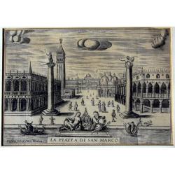
La piazza di San Marco.
Very rare view of Piazza San Marco from Stefano Scolari, circa 1640. Together with the second view offered also here appears rarely on the international market.
Date: Venice, circa 1640
Selling price: ????
Please login to see price!
Sold in 2018
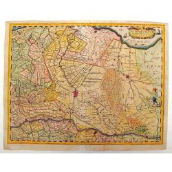
Comitatus Hollandiae novissima description Designatore Balthazaro Florentio a Berckenrode Anno Domini 1629.
Highly detailed regional map of Holland, showing the area around Amsterdam, Utrecht, Rotterdam, with an inset upper right corner of the Dutch Islands of Texel, Vlielandt....
Date: Amsterdam, 1640
Selling price: ????
Please login to see price!
Sold in 2020
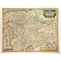
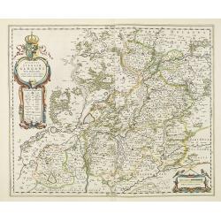
Westphalia Ducatus.
A fine and detailed engraved map of Westphalia, produced by the famous Dutch Blaeu Family. The mountainous topography is graphically depicted, and several small coats of ...
Date: Amsterdam, ca. 1640
Selling price: ????
Please login to see price!
Sold in 2016
Episcopatus Hildesiensis Descriptio Novissima..
This is Jansson's attractive map centered on the city of Hildesheim. The map was prepared by Joannes Michael Gigas (1580-1650+), a doctor, mathematician and geographer. T...
Date: Amsterdam, ca. 1640
Selling price: ????
Please login to see price!
Sold in 2016
Osnabrugensis episcopatus
A beautiful map of Münster centered on the city of Osnabruck. Prepared by Joannes Michael Gigas (1580-1650+), a doctor, mathematician and geographer. Showing an inset wi...
Date: Amsterdam, 1640
Selling price: ????
Please login to see price!
Sold in 2016
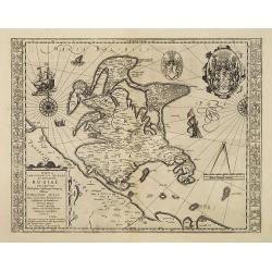
Tabula Russiae.
An early, very attractive map of the region. It includes Scandinavia, as well as the Black and Caspian Seas. Based on Hessel Gerritsz' rare and significant map of Russia,...
Date: Frankfurt, 1640
Selling price: ????
Please login to see price!
Sold in 2016
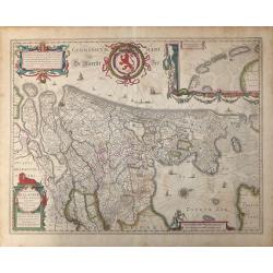
Hollandia.
The Allardt edition of Blaeu's map of Holland, first published in 1604, being the oldest Dutch map to include town views as decorative borders. The top and bottom borders...
Date: Amsterdam, 1640
Selling price: ????
Please login to see price!
Sold in 2024
Insularum Moluccarum Nova descriptio.
Exquisite map of the famous Spice Islands based on the islands described by Jan Huyghen van Linschoten. This map was the first large scale map of the region and depicts t...
Date: Amsterdam, 1640
Selling price: ????
Please login to see price!
Sold in 2017
Nova illustri simi ducatus Pomeraniae..
Very beautiful and detailed map of northern Poland. The map is surmounted by an enormous coat of arms surrounded by two figures. In the left upper part, a circular cartou...
Date: Amsterdam, 1640
Selling price: ????
Please login to see price!
Sold in 2019
Secunda Pars Brabantiae cuiuc urbs primaria Bruxellae.
A clean example of Blaeu's map of the region of Brabant with Bruxelles, Mechelen and Louven. The map has a decorative cartouche, four coats of arms, compass rose and a mi...
Date: Amsterdam, 1640
Selling price: ????
Please login to see price!
Sold in 2017
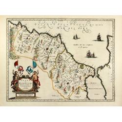
Andaluzia continens Sevillam . . .
ENGLISH TEXT EDITION Showing Gibraltar and the province of Andalusia and the city of Seville. Depicted also are the Straights of Gibraltar, know in classical times as the...
Date: Amsterdam, 1640
Selling price: ????
Please login to see price!
Sold in 2018
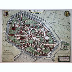
Mons.
One of the finest and most sought-after view of Mons. The format emphasizes the layout of the city with buildings, churches, gardens, streets, walls, bridges and fortific...
Date: Amsterdam, 1640
Selling price: ????
Please login to see price!
Sold in 2018
Alsatia Landgraviatus, cum Suntgoia et Brisgoia,. .
A large, detailed, and handsome map of Alsace, a famous wine region of France, based on the work of Gerard Mercator. It covers the region including the Rhine from Granvil...
Date: Amsterdam, 1640
Selling price: ????
Please login to see price!
Sold in 2016
Diocese de Rheims, et le pais de Rethel...
Attractive map of the department in the Champagne-Ardenne region of France. Centred on Reims city. Many towns, forests, and waterways are identified. Decorated with the b...
Date: Amsterdam, ca. 1640
Selling price: ????
Please login to see price!
Sold in 2016
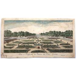
Veue et Perspective du Parterre du Palais d'Orleans.
Delecate copper engraving of the grounds around Orleans Palace. It demonstrates the symmetry of the gardens.Gabriel Perelle (1604 - 1677)was a French draftsman and printm...
Date: Paris , 1640
Selling price: ????
Please login to see price!
Sold in 2018