Browse Listings
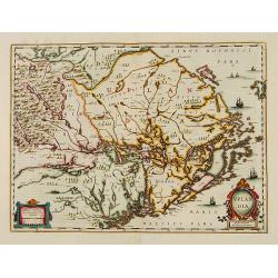
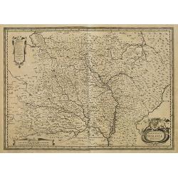
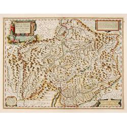
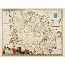
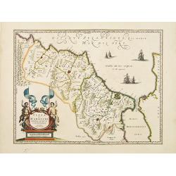
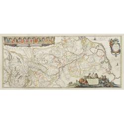
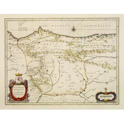
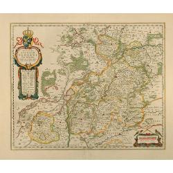
Uplandia.
Covers the area of the modern Uppsala, the vicinity of Stockholm, and includes most of Aland.
Date: Amsterdam, 1639
Selling price: ????
Please login to see price!
Sold in 2012
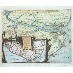
Abbildung der Statt und Festung Parayba in der Landschaft Brasilia.
A splendid map of the region of Paraiba and the forts at the mouth of the Paraiba. The map illustrates the Dutch incursion into the Portuguese territory and shows the Dut...
Date: Frankfurt, 1639
Selling price: ????
Please login to see price!
Sold in 2015
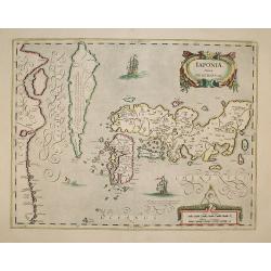
IAPONIAE Nova Descriptio.
2nd state of Hondius map. Janssonius replaced the Japanese ship with a European one.
Date: Amsterdam, 1639
Selling price: ????
Please login to see price!
Sold in 2009
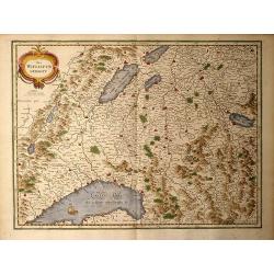
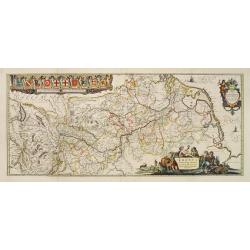
Das Wiflispurgergou
Nice early 17th century copper engraved map of south-western Switzerland of G. Mercator by Hondius in beautiful colors. Second state, with cartouche changed to the shape ...
Date: Amsterdam, 1639
Selling price: ????
Please login to see price!
Sold in 2009
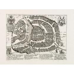
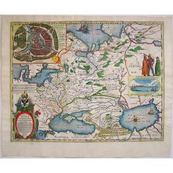
Moscovia urbs Metropolis totius Russiae Albae.
Extremely rare and detailed bird's-eye view of the town of Moscow by Giacomo Lauro (active about 1584-1637), taken from "Heroico Splendore delle Città del Mondo&quo...
Date: Rome, dated 1628, or 1639
Selling price: ????
Please login to see price!
Sold in 2009
Marchionatus Moraviae Auct I. Comenio.
Centered on Brno and Olomouc in south eastern part of Czech Republic.The cartographer of this map was Johan Amos Comenius (1592-1670), Czech cartographer and priest.
Date: Amsterdam, 1639
Selling price: ????
Please login to see price!
Sold in 2015
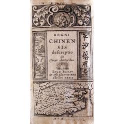
Regni Chinensis Descriptio.
Lugduni Batavorum (Leiden), ex off, Elzeviriana, in-24o, (viii) + 365 pp + (9) nn pp (index), with decorative engraved title depicting a map of China and 2 woodcut costum...
Date: Leiden, Elzevier,1639
Selling price: ????
Please login to see price!
Sold in 2010
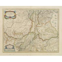
Ducatus Geldria.
West to the top. Including Gelderland, but also the provinces of Utrecht, Gelderland and part of Brabant. Engraved by the master-engraver Abraham Goos.
Date: Amsterdam, 1639
Selling price: ????
Please login to see price!
Sold in 2019
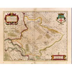
Comitatus Zutphania.
A very detailed map of this area, including Arnhem, Nijmegen, Zutphen, Groenlo, etc.
Date: Amsterdam, 1639
Selling price: ????
Please login to see price!
Sold in 2022
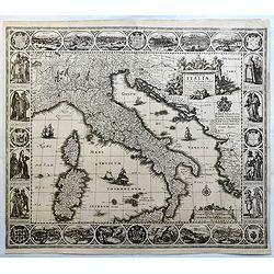
Tabulae Italiae, Corsicae, Sardiniae, et adjacentium..
A decorative map by this famous Dutch mapmaker. The border contains views of the main cities, largely inspired by the Civitates Orbis Terrarum by Braun & Hogenberg: R...
Date: Amsterdam, 1628,1640
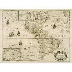
Carte de L'Amerique. . .
The map is based on the Jodocus Hondius map of 1618. The entire west coast of North America, including nomenclature, is erased and replaced by a dotted coastline with the...
Date: Paris, 1640
Selling price: ????
Please login to see price!
Sold in 2016
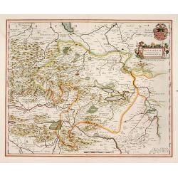
Mansfeldia Comitatus.
Centered on Mansfeld and prepared by Tilemano Stella (1527-1589) a German cartographer who made maps of Germany and the Holy Land.The scale of longitude and latitude are ...
Date: Amsterdam, 1640
Selling price: ????
Please login to see price!
Sold in 2014
Alpinae seu Foederatae Rhaetiae subditarumque..
Detailed map Graubunden Canton in Switzerland. Including Chur, Davos, St.Moritz, etc. Engraved by Simon Hamersveldt.The scale of longitude and latitude are colored altern...
Date: Amsterdam 1640
Selling price: ????
Please login to see price!
Sold
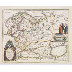
Tabula Russiae.
An attractive map of the region including all of Scandinavia through to the Black and Caspian Seas. The map is based on Hessel Gerritsz' rare and significant map of Russi...
Date: Frankfurt, 1640
Selling price: ????
Please login to see price!
Sold in 2013
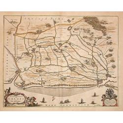
Le gouvernement de Calais & Païs reconquis.
An attractive map of the north-western part of France including the towns of Calais, Gravelines. South to the top.
Date: Amsterdam 1640
Selling price: ????
Please login to see price!
Sold
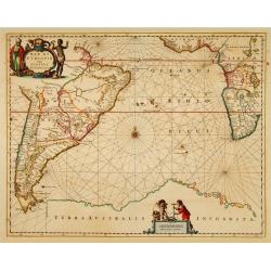
Mar di Aethiopia.
This from Johannes Janssonius' sea-atlas 'De Water-Weereld' covers the area between the Cape of Good Hope and the most southern tip of South America. Giving many place n...
Date: Amsterdam, 1640
Selling price: ????
Please login to see price!
Sold in 2021
Belsia, Vulgo La Beausse.
In the left-hand lower part of the image a beautiful contemporary colored cartouche with goddess Ceres [agricultural] holding a reaping-hook in her right hand and receivi...
Date: Amsterdam, 1640
Selling price: ????
Please login to see price!
Sold in 2011
![Nova Totius Terrarum Orbis Geographica ac Hydrographica Tabula auct: Guiljelmo Blaeuw [and] Africae nova descriptio [and] Americae nova Tabula [and] Asia noviter delineata [and] Europa recens descripta](/uploads/cache/99911-250x250.jpg)
Nova Totius Terrarum Orbis Geographica ac Hydrographica Tabula auct: Guiljelmo Blaeuw [and] Africae nova descriptio [and] Americae nova Tabula [and] Asia noviter delineata [and] Europa recens descripta
A matching set of the World and the Continents by Willem J. Blaeu in attractive original colors These five maps represent the apogee of seventeenth century Dutch cartogra...
Date: Amsterdam, 1640
Selling price: ????
Please login to see price!
Sold in 2011
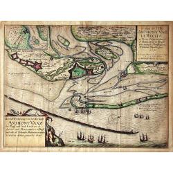
Grondt-Tekening van het Eylandt ANTHONY VAAZ het Reciff ende vaste Landt aen de haven van PERNAMBUCO in Brasil..
EXTREMELY RARE MAP engraved by Willem Hondius and published by Claes Jansz. Visscher.A detailed map of the Island of Anthony Vaaz. In upper left corner an inset of Fort d...
Date: Amsterdam 1640
Selling price: ????
Please login to see price!
Sold
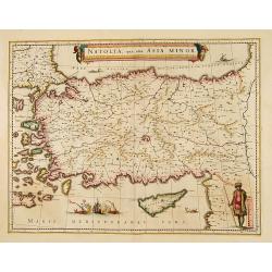
Natolia, quae olim Asia minor.
A finely designed map from the great Blaeu family of Amsterdam.
Date: Amsterdam, 1640
Selling price: ????
Please login to see price!
Sold in 2008
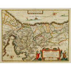
TERRA SANCTA quae in Sacris Terra Promissionis?
The Holy Land, Promised Land or Palestine. Oriented to the west. Shows the entire Palestine on both sides of the Jordan, the shore line running from Tripoli as far as the...
Date: Amsterdam 1640
Selling price: ????
Please login to see price!
Sold
Edynburgum.
From Merian's "Topographia," a beautifully presented panoramic view of Edinburgh in the mid 17th century. Edinburgh Castle is shown in the left portion of the p...
Date: Frankfurt, ca. 1640
Selling price: ????
Please login to see price!
Sold
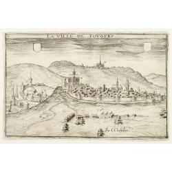
La Ville de Fovgers.
Charming view of Fougères, in Brittany.
Date: Paris, ca. 1640
Selling price: ????
Please login to see price!
Sold
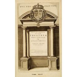
(Title page) Teatrum Orbis Terrarum.
Architectural frontage with the title and imprint printed on paste-on slips.The heraldic shield, with crown and garters.
Date: Amsterdam, 1640
Selling price: ????
Please login to see price!
Sold in 2013
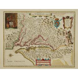
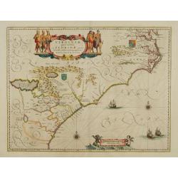
Nova Virginiae Tabula.
The map is based on the first state of Smith's map, 1612, and is slightly larger and more expertly engraved. In 1629 the Hondius plate was purchased by Blaeu who deleted ...
Date: Amsterdam 1640
Selling price: ????
Please login to see price!
Sold
Virginiae Partis Australis, et Floridae Partis Orientalis.
Blaeu based this map on the Mercator-Hondius of 1606. A number of geographical improvements, however were incorporated, although two large fictions lakes accompanied by e...
Date: Amsterdam 1640
Selling price: ????
Please login to see price!
Sold
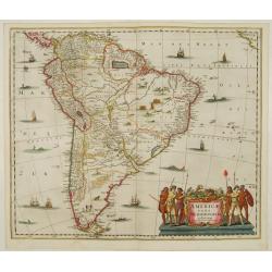
Americae Pars Meridionalis.
Decorated with several ships and sea monsters, and a cartouche flanked by engravings of six Indians, netted hammocks and South American fauna.
Date: Amsterdam 1640
Selling price: ????
Please login to see price!
Sold
America Septentrionalis.
Showing California as an island, and above, the north west of the continent left blank except for two legends explaining the discoveries to that date. The Hudson Bay is c...
Date: Amsterdam 1640
Selling price: ????
Please login to see price!
Sold
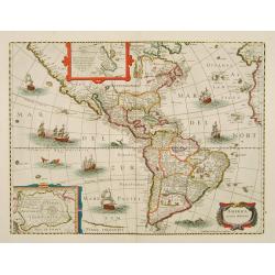
America noviter delineata.
With inset details of the North and South Poles, and several ships and sea-monsters. Hondius shows the imaginary island of Frisland, Southeast of Iceland, and gives Picar...
Date: Amsterdam 1640
Selling price: ????
Please login to see price!
Sold
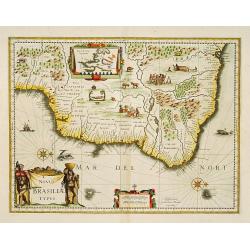
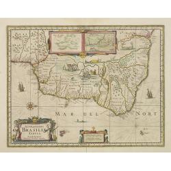
Novus Brasiliae Typus.
A decorative map with a title cartouche of two natives: in the interior is an inset of Baya de todos os Sanctos (Salvador), indigenous wild life and cannibal scenes. Orig...
Date: Amsterdam 1640
Selling price: ????
Please login to see price!
Sold
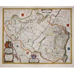
Novissima Arragoniae..
Shows cities of Saragossa and Pamplona. Dedication to a list of worthies, deputies of the king in Aragon by Henricus Hondius.
Date: Amsterdam 1640
Selling price: ????
Please login to see price!
Sold
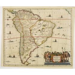
Americae Pars Meridionalis.
Finely engraved map of South America. Decorated with several ships and sea monsters, and a cartouche flanked by engravings of six Indians, netted hammocks and South Ameri...
Date: Amsterdam 1640
Selling price: ????
Please login to see price!
Sold
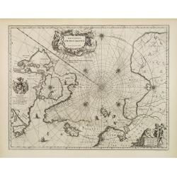
Regiones Sub Polo Arctico.
One of the many cases of duplication by the firms of Blaeu and Hondius/Jansson. In this case, Blaeu has copied Jansson's map of 1637. It depicts rhumb lines radiating fro...
Date: Amsterdam 1640
Selling price: ????
Please login to see price!
Sold
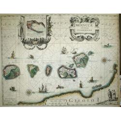
Moluccae Insulae Celeberrimae.
Nice map of the Moluccan Islands in the Indonesian Archipelago.Beautiful cartouches. Verso blanc.
Date: Amsterdam, c 1640
Selling price: ????
Please login to see price!
Sold
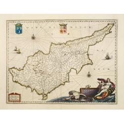
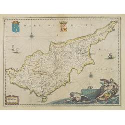
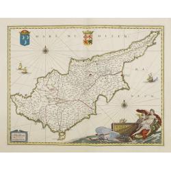
Cyprus Insulae.
Janssonius' beautiful chart of Cyprus embellished with a very decorative title cartouche.
Date: Amsterdam 1640
Selling price: ????
Please login to see price!
Sold
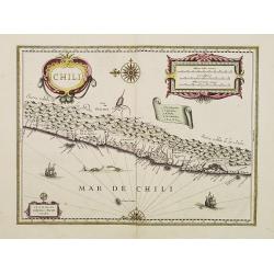
Chili.
Willem Blaeu's very decorative map of Chili with two large and beautiful cartouches, a compass and ships.
Date: Amsterdam 1640
Selling price: ????
Please login to see price!
Sold
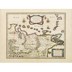
Venezuela, cum parte Australi novae Andalusiae.
A finely engraved, decorative map with Latin text on the reverse. The islands Trinidad, Margarita, Aruba and Curaçao are shown as well. With decorative title cartouche.T...
Date: Amsterdam 1640
Selling price: ????
Please login to see price!
Sold
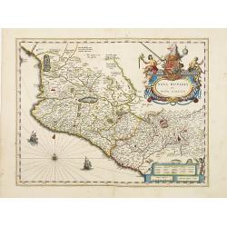
Nova Hispania et Nova Galicia.
Map of New Spain and New Galicia shows the city of Mexico situated by a large lake, as well as the location of many silver and gold mines. The map's elaborate cartouche i...
Date: Amsterdam 1640
Selling price: ????
Please login to see price!
Sold
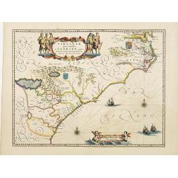
Virginiae Partis Australis, et Floridae Partis Orientalis.
Blaeu based this map on the Mercator-Hondius of 1606. A number of geographical improvements, however were incorporated, although two large fictions lakes accompanied by e...
Date: Amsterdam 1640
Selling price: ????
Please login to see price!
Sold
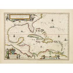
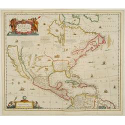
Insulae Americanae in Oceanus Septentrionali cum Terris..
General map of the West Indies extending from Virginia to the mouth of the Orinoco, and destined to be copied in various shapes by many other publishers.Title cartouche t...
Date: Amsterdam 1640
Selling price: ????
Please login to see price!
Sold
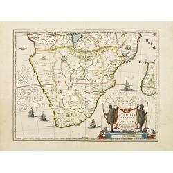
Aethiopia inferior, vel exterior.
The standard map of South Africa throughout the 17th century. The lake out of which the 'Zambere' -the Zambesi- flows is probably based on reports of Lake Ngami, undiscov...
Date: Amsterdam 1640
Selling price: ????
Please login to see price!
Sold
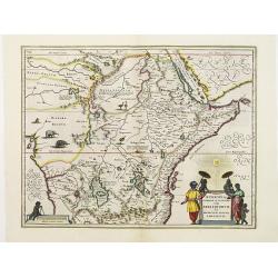
Aethiopia Superior vel Interior vulgo Abissinorum.
An attractive map of the Eastern African and the fictitious kingdom of Prester John. The map shows a major section of central and eastern Africa including Mozambique nort...
Date: Amsterdam 1640
Selling price: ????
Please login to see price!
Sold
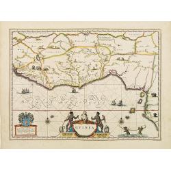
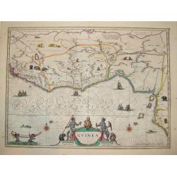
Guinea.
An attractive map covered with intersecting rhumb lines and decorated with monkeys, lions, elephants and native figures. With a dedication to Dr. Nicolas Tulp.
Date: Amsterdam 1640
Selling price: ????
Please login to see price!
Sold
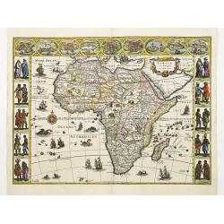
Africae nova descriptio.
Much of the geographical information is still based on the Ptolemaic maps, with the Nile shown with its source in the Lakes Zaire and Zaflan. Also included are various ot...
Date: Amsterdam 1640
Selling price: ????
Please login to see price!
Sold
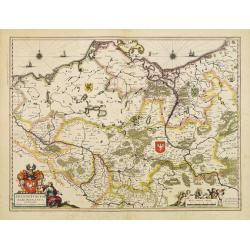
Brandenburgum Marchionatus cum Ducatibus Pomerani..
Covering the area of Mecklenburg-West Pomerania, including the towns of Rustock, Szczechi, etc.Embellished with coats of arms, sailing ships and windroses.
Date: Amsterdam, 1640
Selling price: ????
Please login to see price!
Sold
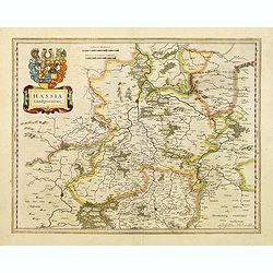
Hassia Landgraviatus.
Detailed map centered on the town of Kassel. With decorative title cartouche.More about Willem Blaeu. [+]
Date: Amsterdam, 1640
Selling price: ????
Please login to see price!
Sold in 2022
Legionis regnum et Asturiarum principatus.
Decorative map of the Spanish Province Asturias, Castile and Léon, including the towns of Oviedo, Leon, Santander, Valladolid, etc. With two fine title cartouches.
Date: Amsterdam 1640
Selling price: ????
Please login to see price!
Sold
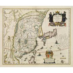
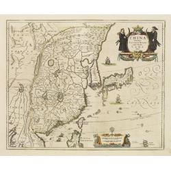
China Veteribus Sinarum Regio nunc Incolis Tame dicta.
Elegant 17th century map of China and Japan. The map is closely modelled on Janssonius' map of 1633. The detail includes the eastern part of China (bounded in the west by...
Date: Amsterdam 1640
Selling price: ????
Please login to see price!
Sold
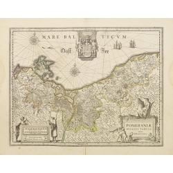
Pomeraniae ducatus Tabula.
Finely engraved map of Pomerania, geographical region today divided between northern Poland and Germany on the south coasts of the Baltic Sea. With decorative title carto...
Date: Amsterdam 1640
Selling price: ????
Please login to see price!
Sold
Cyprus Insulae.
Janssonius' beautiful map of Cyprus embellished with a very decorative title cartouche.
Date: Amsterdam, 1640
Selling price: ????
Please login to see price!
Sold in 2008
Rhenus Fluviorum Europae..
Shows the course of the River Rhine, showing parts of Switzerland, Austria, The Netherlands and part of Germany.The finest Dutch map publishers were the Blaeu family, and...
Date: Amsterdam 1640
Selling price: ????
Please login to see price!
Sold
Guinea.
One of the most beautiful and graphic maps to be found, covering the east coast of Africa from Sierrra Leone to Gabon. The interior is decorated with many wild animals, s...
Date: Amsterdam, ca. 1640
Selling price: ????
Please login to see price!
Sold in 2008

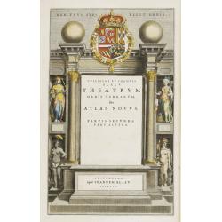
Theatrum Orbis Terrarum sive Atlas Novus. Partis Primae Pars Altera.
Johan Blaeu succeeded his father Willem when the latter died in 1638. Johan led the Blaeu firm to its greatest achievement the ' Atlas Maior' in 12 parts, the greatest an...
Date: Amsterdam, 1640
Selling price: ????
Please login to see price!
Sold
Arragonia Regnum.
Johan Blaeu succeeded his father Willem when the latter died in 1638. Johan led the Blaeu firm to its greatest achievement the ' Atlas Maior' in 12 parts, the greatest an...
Date: Amsterdam, 1640
Selling price: ????
Please login to see price!
Sold
China Veteribus Sinarum Regio.
Based on Jesuit surveys, the map represents the next major revision in the cartography of China after Ortelius' 1584 map. Korea, however, is still an island, and Japan co...
Date: Amsterdam 1640
Selling price: ????
Please login to see price!
Sold
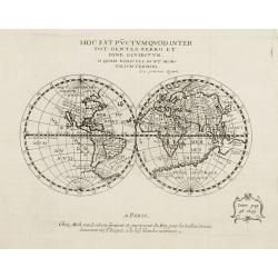
Hoc est pvctvm qvod inter...
World map in double hemisphere, showing California as an island. Published by Michael van Lochom (1601-47). Engraver, publisher and Royal Printer active in Rue St.Jacques...
Date: Paris 1640
Selling price: ????
Please login to see price!
Sold
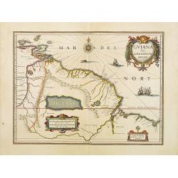
Guiana sive Amazonum Regio.
Nice map extending from the Isla Margarita in the northwest to the coast of northern Brazil near Sao Luis east of the Amazon delta. The map locates at its center a large ...
Date: Amsterdam, 1640
Selling price: ????
Please login to see price!
Sold in 2008
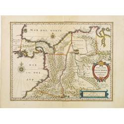
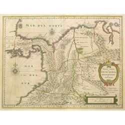
Terra Firma et Novum regnum Granatense et Propayan.
Fine copy, with wide margins of this handsome map of the Isthmus of Panama and northwestern South America including most of present day Columbia and part of Venezuela. Te...
Date: Amsterdam, 1640
Selling price: ????
Please login to see price!
Sold
Fezzae et Marocchi regna Africae celeberrima.
An attractive map of northwest Africa and Morocco. The Pillars of Hercules & Straits of Gibraltar, and Spain are shown to the right of the map (north is to the right ...
Date: Amsterdam, 1640
Selling price: ????
Please login to see price!
Sold
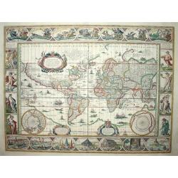
Nova Totius Terrarum Orbis Geographica Ac Hydrographica Tabula
Magnificent world map on Mercator's projection. Petrus Plancius world map of 1592 was the main source of geographical information for the map. A supreme example of the ma...
Date: Amsterdam, 1640
Selling price: ????
Please login to see price!
Sold
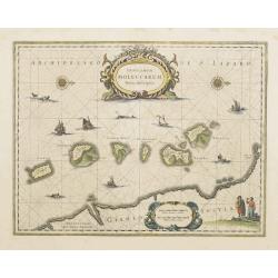
Insularum Moluccarum Nova descriptio.
Exquisite map of the famous Spice Islands based on the islands described by Jan Huyghen van Linschoten. This map was the first large scale map of the region and depicts t...
Date: Amsterdam, 1640
Selling price: ????
Please login to see price!
Sold
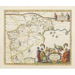
Pecheli sive Peking imperii sinarum provincia prima.
The map of the province of Peking from Joan Blaeu's Novus Atlas Sinensis , the first atlas of china with maps by the hand of the Italian Jesuit Martino Martini. A beautif...
Date: Amsterdam, 1640
Selling price: ????
Please login to see price!
Sold
Rhenus Fluviorum Europae..
Shows the course of the River Rhine, showing parts of Switzerland, Austria, The Netherlands and part of Germany.The finest Dutch map publishers were the Blaeu family, and...
Date: Amsterdam, 1640
Selling price: ????
Please login to see price!
Sold
Title page from "Theatrum Orbis Terrarum sive Atlas Novus".
Attractive title page of Blaeu's Theatrum Orbis Terrarum. The title is printed on a paste-on slip.Decorative and finely engraved architectural façade with figures. Some ...
Date: Amsterdam, 1640
Selling price: ????
Please login to see price!
Sold
Cyprus Insula.
Blaeu's beautiful map of Cyprus embellished with a very decorative title cartouche, a scale cartouche, two coats of arms, two wind roses and three sailing ships.With &quo...
Date: Amsterdam, 1640
Selling price: ????
Please login to see price!
Sold
Byzantium nunc Constantinopolis.
One of the finest and most sought-after views of Istanbul. Viewed from the village of Scutari, the City is shown with all its fortifications, the original Genouse distric...
Date: Amsterdam, 1640
Selling price: ????
Please login to see price!
Sold in 2008
Legionis regnum..
Decorative map of the Spanish Province Asturias, Castile and Léon, including the towns of Oviedo, Leó,n, Santander, Valladolid, etc. With two fine title cartou...
Date: Amsterdam, 1640
Selling price: ????
Please login to see price!
Sold in 2008
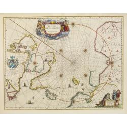
Regiones Sub Polo Arctico.
One of the many cases of duplication by the firms of Blaeu and Hondius/Jansson. In this case, Blaeu has copied Jansson's map of 1637. It depicts rhumb lines radiating fro...
Date: Amsterdam, 1640
Selling price: ????
Please login to see price!
Sold in 2009
Accuratissima Brasiliae Tabula.
Early map of Brazil showing settlements, coastal features, and the hereditary captaincies of the 17th century. The named cities include Sao Sebastian (Rio de Janeiro), Sa...
Date: Amsterdam, c.1640
Selling price: ????
Please login to see price!
Sold in 2011
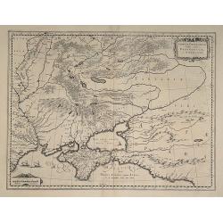
Tavrica Chersonesva Mostra aetate Prezecopsca et Gazara dicitur
Nice map of the Ukraine with in the north Moscow. On verso Latin text ?Tavrica Chersonesus? F2 Urbes. Very slight discoloring on fold.
Date: c. 1640
Selling price: ????
Please login to see price!
Sold in 2008
Ducatus Silesiae Glogani Vera Delineatione
Beautiful full old colored example of Blaeu's map of Glogau in Lower Silesia Province in Poland. From a Spanish edition of "Atlas Maior".
Date: Amsterdam, 1640
Selling price: ????
Please login to see price!
Sold in 2009
Terra Firma et Novum Regnum Granatense et Popayan
The northwest corner of South America including present day Panama and Columbia. Shows Panama City, Cartagena and Cali. Graphically depicts the rugged terrain of the uppe...
Date: Amsterdam, 1640
Selling price: ????
Please login to see price!
Sold in 2009
Tabula Russiae
Tabula Russiae... dicta Moscovia. An attractive map of the region including all of Scandinavia through to the Black and Caspian Seas. The map is based on Hessel Gerritsz\...
Date: Amsterdam, c. 1640
Selling price: ????
Please login to see price!
Sold in 2008
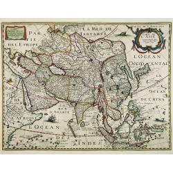
Carte de l' Asie. . . Didiée a Maitre Pierre Petit. . .
Rare map of Asia, with the address of Michel van Lochom, dated 1640.The map is of interest for the dual-naming of the sea between Korea and Japan, here called "MER D...
Date: Paris, c. 1640
Selling price: ????
Please login to see price!
Sold in 2015
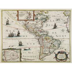
Carte de L'Amerique Corrigee et augmentee dessus toutes les autres . . .
Very rare map of the Americas engraved by Michel van Lochom. A second state who clearly shows signs of reworking and Burden believes that it is the same as that of 1624 l...
Date: Paris, 1640
Selling price: ????
Please login to see price!
Sold in 2016
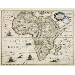
Carte de l' Afrique. . .
Very rare map of Africa.Prepared by P.Bertius and published by Michel van Lochem (1601-47). He was engraver and royal printer, active at "Rue St.Jacques à la Rose B...
Date: Paris, 1640
Selling price: ????
Please login to see price!
Sold in 2008
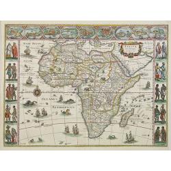
Africae nova descriptio.
Fine "carte à figures"- map of the continent of Africa. Much of the geographical information is still based on the Ptolemaic maps, with the Nile shown with its...
Date: Amsterdam, 1640
Selling price: ????
Please login to see price!
Sold in 2012
Fionia vulgo Funen
Beautiful old colored map of Funen in Denmark from J. Blaeu. Showing Funen, Als and Langeland. With one colored cartouche and scale.
Date: Amsterdam, 1640
Selling price: ????
Please login to see price!
Sold in 2009
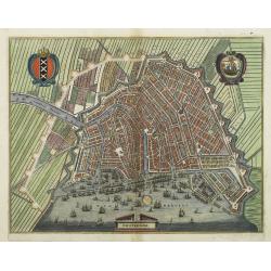
Amsterdam.
Bird's eye view of the busy harbour of Amsterdam with the city shown in plan. Individual buildings can be seen with gardens behind them. Clearly shows the canal system, c...
Date: Frankfurt, 1640
Selling price: ????
Please login to see price!
Sold in 2009
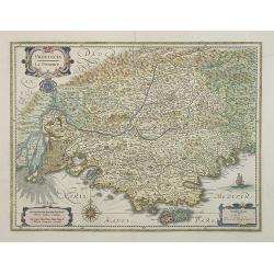
Provincia. La Provence.
Detailed map of the Province including the towns of Marseille, Avignon, Nice, Aix-en-Provence, Sisteron, Cannes, St. Tropez, Toulon, etc. Three decorative cartouches, coa...
Date: Amsterdam, 1640
Selling price: ????
Please login to see price!
Sold in 2014