Browse Listings
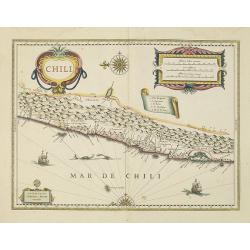
Chili.
Willem Blaeu's very decorative map of Chili with two large and beautiful cartouches, a compass and ships. The modern cities of Santiago (identified on the map as "S ...
Date: Amsterdam, 1638
Selling price: ????
Please login to see price!
Sold in 2010
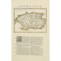
Sardinia Insula.
Map of Sardinia in copper engraving on a sheet with letterpress with French text description of the island.As Willem Blaeu died in 1638 most of his maps are actually publ...
Date: Amsterdam, 1638
Selling price: ????
Please login to see price!
Sold in 2010
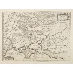
Taurica Chersonesus, Nostra aetate Przecopsca, et Gazara dicitur.
Part of Russia with in the north Smolensk and Moscow and in the south the Black Sea.
Date: Amsterdam, 1638
Selling price: ????
Please login to see price!
Sold in 2010
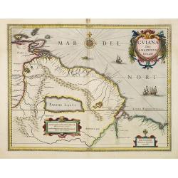
Guiana sive amazonum regio.
This decorative map shows Guiana with the neighboring Trinidad and the adjacenting Amazon river. In the left lower side is a decorative renaissance mileage scale and in t...
Date: Amsterdam, 1638
Selling price: ????
Please login to see price!
Sold in 2010
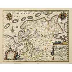
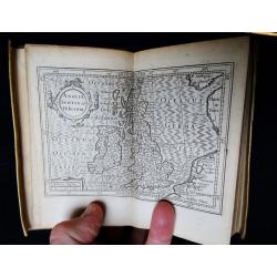
Typus Frisiae Orientalis. . .
Decorative map of east Friesland in Germany with the Watten islands. With inset map of the area south of Emden.Prepared by Ubbo Emmius (1547-1625).As Willem Blaeu died in...
Date: Amsterdam, 1638
Selling price: ????
Please login to see price!
Sold in 2010
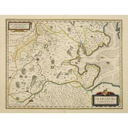
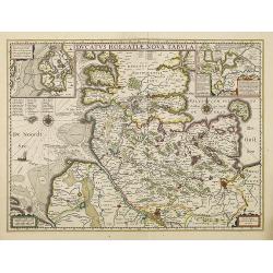
Oldenburg Comitatus.
Willem Blaeu's attractive map of Oldenburg, also depicting Bremen. As Willem Blaeu died in 1638 most of his maps are actually published by his son Joan. This maps carries...
Date: Amsterdam, 1638
Selling price: ????
Please login to see price!
Sold in 2016
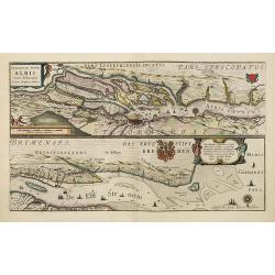
Celeberrimi Fluvis Albis nova delineatio.
Beautiful map of the river Elbe and Hamburg. French text on verso.Originally engraved for Jodocus Hondius, at his death on August 18, 1629, this among 39 other Hondius co...
Date: Amsterdam, 1638
Selling price: ????
Please login to see price!
Sold in 2013
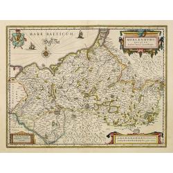
Meklenburg Ducatus.
Finely engraved map with a very decorative title cartouche adorned with a chain of fruits. A ship is sailing on the Baltic near a wind rose. In the left-hand upper part, ...
Date: Amsterdam, 1638
Selling price: ????
Please login to see price!
Sold in 2021
Ducatus Holsatiae nova tabula.
Finely engraved map centered on the area north of Hamburg and Lubeck with two insets.This is a second state of a map initially made by Jodocus Hondius.As Willem Blaeu die...
Date: Amsterdam, 1638
Selling price: ????
Please login to see price!
Sold in 2014
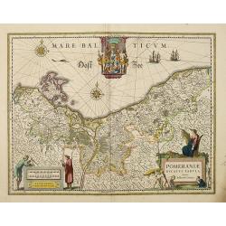
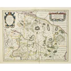
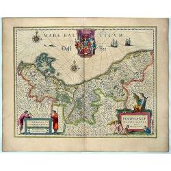
Pomeraniae Ducatus Tabula. Auctore Eilhardo Lubino.
Poland with eastern Germany.As Willem Blaeu died in 1638 most of his maps are actually published by his son Joan. This maps carries his (engraved) signature and was actua...
Date: Amsterdam, 1638
Selling price: ????
Please login to see price!
Sold in 2013
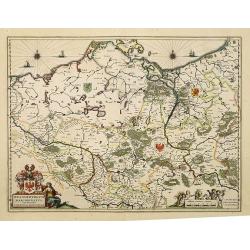
Brandeburgum Marchionatus. . .
Decorative map of part of Pomerania, Mecklenburg and Rugia with excellent detail of forests, rivers, towns and villages. Ornamented with two compass roses, cherubs and pu...
Date: Amsterdam, 1638
Selling price: ????
Please login to see price!
Sold in 2019
Thuringia landgraviatus.
Attractive map of Thüringen based on Adolar Erich's important map of 1625. Roughly centered on Erfurt, it extends to include Mansfield, Halle, Muhlhausen and Meiningen. ...
Date: Amsterdam, 1638
Selling price: ????
Please login to see price!
Sold in 2014
Episcopatus Hildesiensis descriptio novissima.
A fine and attractive mid-17th century folio sheet copper engraved map of the region around Hildesheim, in Lower Saxony. Includes numerous cities and corresponding coat o...
Date: Amsterdam, 1638
Selling price: ????
Please login to see price!
Sold in 2017
Ducatus Luneburgensis Adiacentiumque regionum delineatio. Auctore Johanne Mellingero.
A fine example of this map of Luneburg, extending from Hamburg to Wolfenbuttel, showing the lower Albis River. Bremen, Lunenborg, Nienborg, Brunswig, Magdenburg and Olden...
Date: Amsterdam, 1638
Selling price: ????
Please login to see price!
Sold in 2017

Paderbornensis Episscopatus Descriptio Nova.
Detailed map centered on Paderborn. Embellished with several coats of arms. Prepared by Joannes Michael Gigas (1580-1650+), a doctor, mathematician and geographer who mad...
Date: Amsterdam, 1638
Selling price: ????
Please login to see price!
Sold in 2017
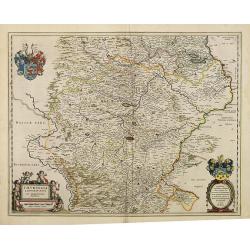
Wirtenberg Ducatus.
Map depicting the area south of Heidelberg, including Stuttgart, Ulm, etc. and the river Danube.A beautiful coat of arms and a splendid title cartouche decorated by three...
Date: Amsterdam, 1638
Selling price: ????
Please login to see price!
Sold in 2010
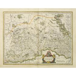
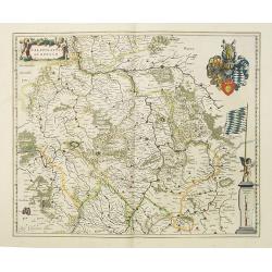
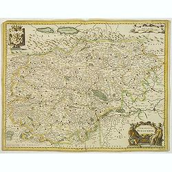
Bavaria Ducatus.
Map shows total Bavaria and prepared by Gerard Mercator. Blaeu is giving credit in the title.A beautiful coat of arms and a splendid title cartouche decorated with chain ...
Date: Amsterdam, 1638
Selling price: ????
Please login to see price!
Sold in 2010
Palatinatus Bavariae.
Map depicting the area south of Heidelberg, including Stuttgart, Ulm, etc.. and river Danube.A beautiful coat of arms and a splendid title cartouche decorated by three ch...
Date: Amsterdam, 1638
Selling price: ????
Please login to see price!
Sold in 2017
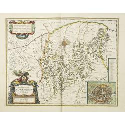
Territorium Norimbergense.
Centered on Nuremberg the capital of the printing shop of Homann. Lower right hand corner inset plan of Nuremberg, with a key to the major buildings. The large title cart...
Date: Amsterdam, 1638
Selling price: ????
Please login to see price!
Sold in 2018
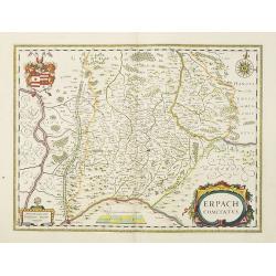
Erpach Comitatus.
Elegantly engraved map of the region including Heidelberg, centered on Eparch and showing part of the River Rhine and River Main with the towns of Gensheim, Worms, Milten...
Date: Amsterdam, 1638
Selling price: ????
Please login to see price!
Sold in 2017
Franconia Vulgo Franckenlandt.
Willem Blaeu's attractive map of Frankenland.As Willem Blaeu died in 1638 most of his maps are actually published by his son Joan. This maps carries his (engraved) signat...
Date: Amsterdam, 1638
Selling price: ????
Please login to see price!
Sold in 2010
Palatinatus ad Rhenum.
Covering southern part of the river Rhine. Including the towns of Frankfurt, Heidelberg, Nuremberg, Spier, etc. Upper right part, beautiful royal arms. Lower right, a sca...
Date: Amsterdam, 1638
Selling price: ????
Please login to see price!
Sold in 2018
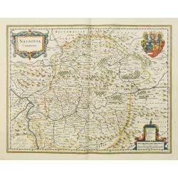
Nassovia Comitatus.
Elegantly engraved map of the region including Koblenz, Sigen and Dillenburg. The mountainous topography is graphically depicted and there is a coats of arms in the corne...
Date: Amsterdam, 1638
Selling price: ????
Please login to see price!
Sold in 2018
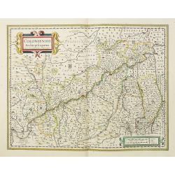
Coloniensis Archiepiscopatus. . .
Detailed map centered on the river Rhine and the city of Cologn, punctuated by several coats of arms.A beautiful coat of arms and a splendid title cartouche decorated by ...
Date: Amsterdam, 1638
Selling price: ????
Please login to see price!
Sold in 2018
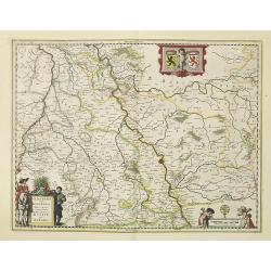
Iuliacensis et Montensis Ducatus.
Finely engraved map depicts the Duchies of Jülich and Berg on the Rhine River. It is richly embellished with cartouches, figures and coats of arms.As Willem Blaeu died i...
Date: Amsterdam, 1638
Selling price: ????
Please login to see price!
Sold in 2021
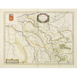
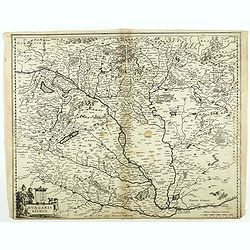
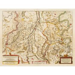
Comitatus Marchia et Ravensberg.
In the center of the map about the decorative cartouche is Hattington and Bochum. In the upper left is the confluence of the Weser and Lippe Rivers. In the lower left is ...
Date: Amsterdam, 1638
Selling price: ????
Please login to see price!
Sold in 2017
Clivia Ducatus et Ravestein Dominium.
A very decorative map showing the towns of Nijmegen, Venlo, Moers and Emmerich.As Willem Blaeu died in 1638 most of his maps are actually published by his son Joan. This ...
Date: Amsterdam, 1638
Selling price: ????
Please login to see price!
Sold in 2018
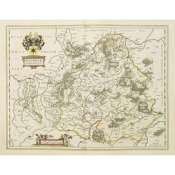
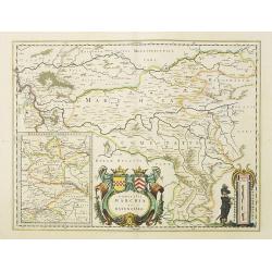
Waldeck Comitatus.
Map centered on Waldeck, Korbach, etc.As Willem Blaeu died in 1638 most of his maps are actually published by his son Joan. This maps carries his (engraved) signature and...
Date: Amsterdam, 1638
Selling price: ????
Please login to see price!
Sold in 2022
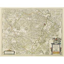
Territorium Abbatiae Heresfel-Densis.
A large seventeenth century hand colored map of the territory of Hirschfeld, (Hersfeld/Hesse) Germany. Shows Bad Hersfeld vicinity. As Willem Blaeu died in 1638 most of h...
Date: Amsterdam, 1638
Selling price: ????
Please login to see price!
Sold in 2017
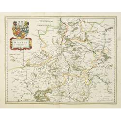
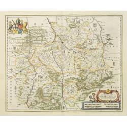
Hassia Landgraviatus.
Very detailed engraved map of Hesse by Willem and Joan Blaeu. With title cartouches and coat of arms. Showing the area between Alsfeld, Northeim and Eisenach. Centered on...
Date: Amsterdam 1638
Selling price: ????
Please login to see price!
Sold in 2017
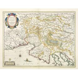
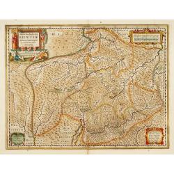
Karstia, Camiola, Histria et Windorum Marchia.
Including the Gulf of Trieste, Venice and the northern part of former Yugoslavia. Prepared by Gerard Mercator.With the signature of Willem Blaeu in lower left corner. As ...
Date: Amsterdam, 1638
Selling price: ????
Please login to see price!
Sold in 2023
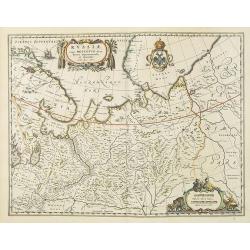
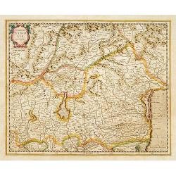
Russiae vulgo Moscovia dictae, partes, septentrionalis et orientalis.
This fine map was compiled from manuscripts brought back from Russia, by Isaac Massa. Covering the area from Finland to Siberia and beyond the Jenisej River and south to ...
Date: Amsterdam, 1638
Selling price: ????
Please login to see price!
Sold
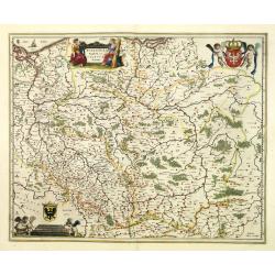
Polonia regnum et Silesia ducatus.
Very decorative map of Poland embellished with two cartouches and two coats of arms surmounted by cherubs and female figures. Showing the region from the Oder east to Pod...
Date: Amsterdam, 1638
Selling price: ????
Please login to see price!
Sold in 2010
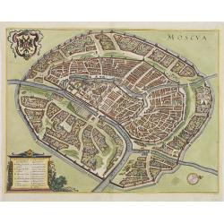
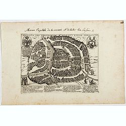
Moscua.
Town-plan of Moscow, with Moscua River, Iausa River, Neglina River, Kremlin, etc. With coat of arms upper left. Numbered and lettered key showing 17 places of interest.
Date: Frankfurt, 1638
Selling price: ????
Please login to see price!
Sold in 2011
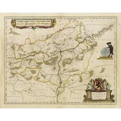
Pomeraniae Ducatus Tabula. Amstelodami, Guiljelm Blaeuw excudit.
This attractive map shows all of the area of Pomerania, in present day eastern Germany and Poland with considerable detail. An elaborate coat of arms of Pomerania is at ...
Date: Amsterdam, (1630) 1635-1638
Selling price: ????
Please login to see price!
Sold in 2012
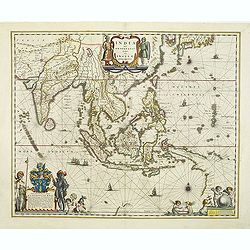
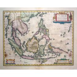
India quae Orientalis dicitur, et insulae adiacentes.
Extending from India to Japan and showing parts of Australia. It is indeed one of the first printed maps to show identifiable parts of Australia. It was not revised until...
Date: Amsterdam, c.1638
Selling price: ????
Please login to see price!
Sold in 2011
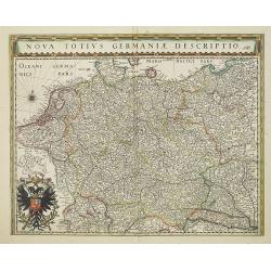
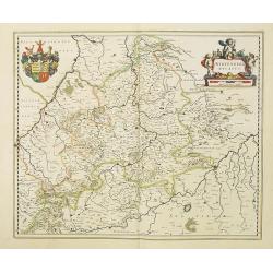
Nova Totius Germaniae Descriptio.
Map of Germany, Low Countries and Poland.As Willem Blaeu died in 1638 most of his maps are actually published by his son Joan. This maps carries his (engraved) signature ...
Date: Amsterdam, 1638
Selling price: ????
Please login to see price!
Sold in 2022
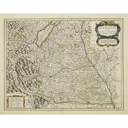
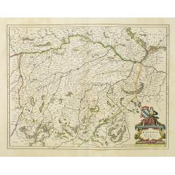
Alemannia sive Suevia Superior.
Detailed map of the Baden-Württemberg region filled with detailed information and a graphic depiction of the mountains to the east. With the Boden See in upper left corn...
Date: Amsterdam, 1638
Selling price: ????
Please login to see price!
Sold in 2022
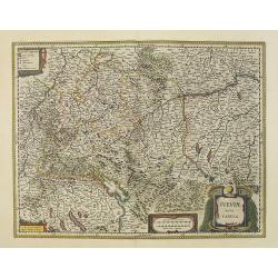
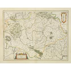
Sueviae nova tabula.
Map depicting the area south of Heidelberg, including Stuttgart, Ulm, etc.. and river Danube.A beautiful coat of arms and a splendid title cartouche decorated by three ch...
Date: Amsterdam, 1638
Selling price: ????
Please login to see price!
Sold in 2012
Comitatus Bentheim et Steinfurt.
French text on verso. An excellent and early map of Bentheim and Steinfurt in Germany. Very decorative title cartouche surrounded by two coats of arms. The scale cartouch...
Date: Amsterdam, 1638
Selling price: ????
Please login to see price!
Sold in 2014
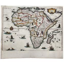
Nova Description AFRICAE.
A decorative example of Merian's map of Africa. This map is richly embellished with animals, including elephants, monkeys, ostriches, gazelles, lions, cheetahs and camels...
Date: Frankfurt, ca 1638
Selling price: ????
Please login to see price!
Sold in 2020
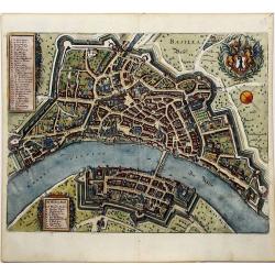
BASILEA Basel.
A decorative detailed plan of Basel, from Merian's "Neuwe Archontologica Cosmica", published in 1638. It shows the Rhine River, bridge, walled city, gates, stre...
Date: Frankfurt, 1638
Selling price: ????
Please login to see price!
Sold in 2020
![[Title page] Le Theatre du Monde ou le nouvel atlas contenant les chartes et descriptions de tous les Païs de la Terre mis en lumière par Guillaume et Jean Blaeu.](/uploads/cache/47928-250x250.jpg)
[Title page] Le Theatre du Monde ou le nouvel atlas contenant les chartes et descriptions de tous les Païs de la Terre mis en lumière par Guillaume et Jean Blaeu.
Frontispiece of " Le Theatre du Monde ou le nouvel atlas contenant les chartes et descriptions de tous les Païs de la Terre mis en lumière par Guillaume et Jean Bl...
Date: Amsterdam, 1638
Selling price: ????
Please login to see price!
Sold in 2022
![[Title page for Janssonius atlas with past-on.]](/uploads/cache/47945-250x250.jpg)
[Title page for Janssonius atlas with past-on.]
Unique title page for an atlas by Janssonius with a past-on of an engraving of a still life with vase and fish-bowl.Read more about decorative atlas title pages [+]
Date: Amsterdam, 1638
Selling price: ????
Please login to see price!
Sold in 2022
De Custen van Engelandt tuschen de droochte van Weembrugh en Poortlandt
Rare sea-chart from Blaeu's Zeespiegel. It shows the area around the Isle of Wight, from Weymouth and the Isle of Portland to Selsey and Chichester, including Poole, Sout...
Date: Amsterdam, ca. 1638
Selling price: ????
Please login to see price!
Sold in 2022
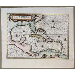
Insulae Americanae in Oceano Septentrionali, cum Terris Adiacentibus.
Early map of the West Indies. Janssonius' edition of Hessel Gerritsz' important map of 1631 made after his voyage to South America and the West Indies during 1628.From Ja...
Date: Amsterdam, 1639
Selling price: ????
Please login to see price!
Sold in 2020
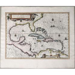
Insulae Americanae in Oceano Septentrionali, cum Terris Adiacentibus.
An early map of the West Indies. Janssonius' edition of Hessel Gerritsz' important map of 1631 made after his voyage to South America and the West Indies during 1628. Fro...
Date: Amsterdam, 1639
Selling price: ????
Please login to see price!
Sold in 2020
![[Title page] Le Nouveau Theatre du Monde Nouvel Atlas Second Tome.](/uploads/cache/46725-250x250.jpg)
[Title page] Le Nouveau Theatre du Monde Nouvel Atlas Second Tome.
A very attractive title page from Le Nouveau Theatre du Monde Nouvel Atlas Second Tome. .
Date: Amsterdam, 1639
Selling price: ????
Please login to see price!
Sold in 2021
Comitatus Burgundiae.
Detailed map showing Burgundy, with decorative cartouches. No text on verso. From a French composite atlas.
Date: Amsterdam, c.1639
Selling price: ????
Please login to see price!
Sold
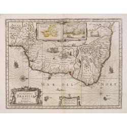
Accuratissima BRASILIAE Tabula.
A decorative map with a title cartouche of two natives, in the interior is an inset of Baya de Todos os Sanctos (Salvador) and "Villa d'Olinda de Pernambuco", i...
Date: Amsterdam, 1639
Selling price: ????
Please login to see price!
Sold in 2013
Indiae Orientalis Nova Descriptio.
From "Atlas Novus, sive theatrum orbus terrarum." Amsterdam, 1639 A.D. French text to verso.The map shows area of south east Asia with their countries of Indone...
Date: Amsterdam, 1639
Selling price: ????
Please login to see price!
Sold in 2016
Comitatus Tirolis cum Consinys.
Very fine and detailed map of Tyrol, covering the towns of Kuffstein, Innsbruck, western part of Boden See, and as far south as tip of Lake Garda with the Italian area Tr...
Date: Amsterdam, 1639
Selling price: ????
Please login to see price!
Sold in 2016
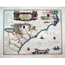
Virginiae Partis australis, et Floridae partis orientalis, interjacentiumqs regionum Nova Descriptio
Important map of the East Coast, from the Chesapeake Bay to Georgia with numerous early place names including Jamestown, Cape Fear, and Newport News. Two coat of arms ill...
Date: Amsterdam, 1639
Selling price: ????
Please login to see price!
Sold in 2016
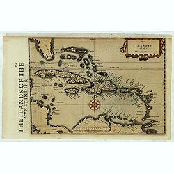
The Ylandes of the West Indies.
Rare map of the West Indies or Caribbean islands from Florida to the northern part of South America. Cartographic elements include degrees of latitude, compass rose, sea ...
Date: London, 1635-1639
Selling price: ????
Please login to see price!
Sold in 2019
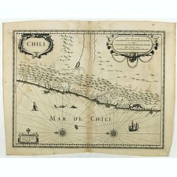
Chili.
Very decorative map of Chili with two large and beautiful cartouches, a compass and ships. Rare without text on verso. From a French composite atlas. Read more about Dutc...
Date: Amsterdam, Paris, ca. 1639
Selling price: ????
Please login to see price!
Sold in 2018
Hungaria Regnum.
Detailed map of Hungary centered on Budapest. Including the towns of Vienna, Zagreb as well.No text on verso. From a French composite atlas.Read more about Dutch - French...
Date: Amsterdam, 1639
Selling price: ????
Please login to see price!
Sold in 2018
Britannia, sive Florentiss. regnorum Angliae, Scotiae, Hiberniae, insularumq. adiacentium ex .
This miniature atlas is an abridged version of Camden's Brittania published by the Blaeu family in Amsterdam. It contains a total of 19 maps, with county maps taken from ...
Date: Amsterdam, 1639
Selling price: ????
Please login to see price!
Sold in 2018
Moscovia urbs Metropolis totius Russiae Albae.
Extremely rare and detailed bird's-eye view of the town of Moscow by Giacomo Lauro (active about 1584-1637), taken from "Heroico Splendore delle Città del Mondo&quo...
Date: Rome, dated 1628, or 1639
Selling price: ????
Please login to see price!
Sold in 2021
![[Vilnius] Vilna Lithuaniae Metropolis.](/uploads/cache/44715-250x250.jpg)
[Vilnius] Vilna Lithuaniae Metropolis.
Extremely rare and detailed bird's-eye view of the town of Vilnius by Giacomo Lauro (active about 1584-1637), taken from "Heroico Splendore delle Città del Mondo&qu...
Date: Rome, 1628 or 1639
Selling price: ????
Please login to see price!
Sold in 2019
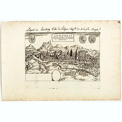
Leopolis Russiae Australis . . .
Extremely rare and detailed bird's-eye view of the town of Lviv by Giacomo Lauro (active about 1584-1637), taken from "Heroico Splendore delle Città del Mondo"...
Date: Rome, 1628 or 1639
Selling price: ????
Please login to see price!
Sold in 2019
![Lublinum [Lublin].](/uploads/cache/44717-250x250.jpg)
Lublinum [Lublin].
Extremely rare and detailed bird's-eye view of the town of Lublin by Giacomo Lauro (active about 1584-1637), taken from "Heroico Splendore delle Città del Mondo&quo...
Date: Rome, 1628 or 1639
Selling price: ????
Please login to see price!
Sold in 2019
![Novum Zamoscium. [Zamosc]](/uploads/cache/44718-250x250.jpg)
Novum Zamoscium. [Zamosc]
Extremely rare and detailed bird's-eye view of the town of Zamosc by Giacomo Lauro (active about 1584-1637), taken from "Heroico Splendore delle Città del Mondo&quo...
Date: Rome, 1628 or 1639
Selling price: ????
Please login to see price!
Sold
Das Wiflispurgergow.
In lower right Geneva and Lake Geneva with Lausanne. In center of map the cantons of Fribourg and Bern.
Date: Amsterdam, 1639
Selling price: ????
Please login to see price!
Sold in 2017
Alpinae seu Foederatae Rhaetiae subditarumque..
Detailed map Graubunden Canton in Switzerland. Including Chur, Davos, St.Moritz, etc. Engraved by Simon Hamersveldt.
Date: Amsterdam 1639
Selling price: ????
Please login to see price!
Sold
Fossa Eugeniana que a Rheno ad Mosam..
Detailed map of part of the country between rivers Rhine and Meuse showing a canal to be dug between 1626 and 1628 between Rheinberg in Germany and Venlo. A deficiency of...
Date: Amsterdam 1639
Selling price: ????
Please login to see price!
Sold
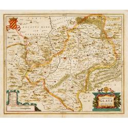
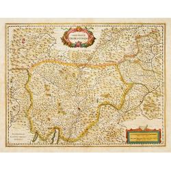
Comitatus Glatz.
Centered on Görlitz. The cartographer of this map was Bartholomeus Scultetus (1540-1614), active in Görlitz.. The title cartouche at bottom right shows ...
Date: Amsterdam 1639
Selling price: ????
Please login to see price!
Sold
Zurichgow et Basiliensis provincia.
Including the towns of Basle, Lucerne, Zürich, etc.
Date: Amsterdam, 1639
Selling price: ????
Please login to see price!
Sold in 2022
Belgii Veteris Typus ex conatibus..
Ancient map of present Netherlands, Belgium and Luxemburg. Engraved by Petrus Kaerius, after design of Abraham Ortelius. Fine title cartouche.
Date: Amsterdam 1639
Selling price: ????
Please login to see price!
Sold
Namurcum Comitatus.
Decorative map centred on Namen. With three very fine cartouches.
Date: Amsterdam, 1639
Selling price: ????
Please login to see price!
Sold in 2023
Belgii Veteris Typus ex conatibus..
Ancient map of present Netherlands, Belgium and Luxemburg. Engraved by Petrus Kaerius, after design of Abraham Ortelius. Fine title cartouche.
Date: Amsterdam 1639
Selling price: ????
Please login to see price!
Sold
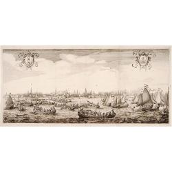
Queen Maria of France arriving at Amsterdam.
Panoramic view of the city from 't IJ. On the foreground extensive shipping being the arrival on August 31, 1638.The print was published in commemoration of Maria de 'Med...
Date: Amsterdam 1639
Selling price: ????
Please login to see price!
Sold
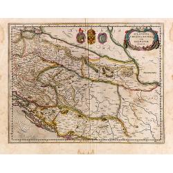
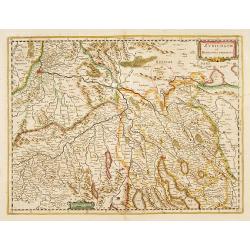
Sclavonia, Croatia, Bosnia cum Dalmatiae Parte.
Detailed and early map with coat-of-arms focusing specifically on the embattled nations of the former Yugoslavia. Signed lower left.
Date: Amsterdam, 1639
Selling price: ????
Please login to see price!
Sold in 2014
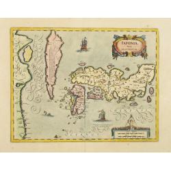
IAPONIAE Nova Descriptio.
2nd state of Hondius map. Janssonius replaced the Japanese ship with a European one. Korea shown as an island.
Date: Amsterdam, 1639
Selling price: ????
Please login to see price!
Sold in 2019
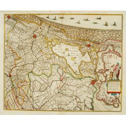
Rhinolandiae, Amstelandiae et ..
Centered on The Hague, Leiden, Haarlem, Amsterdam, Gouda, etc. West to the top. Prepared by Balthasar Floris van Berkenrode.
Date: Amsterdam, 1639
Selling price: ????
Please login to see price!
Sold
Territorium Tridentinum.
Detailed map centered on Trento. Showing the Dolomites mountains, northern tip of Lake Garda, Bolzano, etc.
Date: Amsterdam, 1639
Selling price: ????
Please login to see price!
Sold in 2013
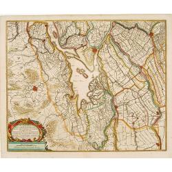
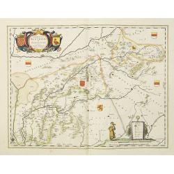
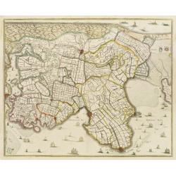
Novissima Tabula Insular Dordracensis. . .
The countship of Holland was subdivided into a number of bailiwicks. The most southerly bailiwick, bordering on Brabant was named Zuid-Holland. Many floods changed the ap...
Date: Amsterdam, 1639
Selling price: ????
Please login to see price!
Sold in 2021
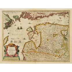
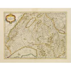
Nova Totius Livoniae accurata Descriptio.
Decorative map of Estonia and Latvia. Including the southern tip of Finland and the south eastern tip of Sweden, including Stockholm.
Date: Amsterdam 1639
Selling price: ????
Please login to see price!
Sold in 2009
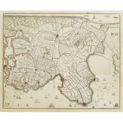
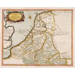
La Hollande Septentrionale.
Large map of the northern part of the province "Holland" in the Netherlands. The map comes from the "Atlas Novus" originally published by Janssonius i...
Date: Amsterdam, 1639
Selling price: ????
Please login to see price!
Sold in 2011
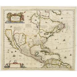
America septentrionalis.
A first state of this important map showing California as an island. Lacking any imprint in the cartouche, lower left. From the first French text edition. The north-west ...
Date: Amsterdam 1639
Selling price: ????
Please login to see price!
Sold
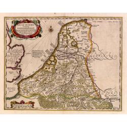
No title: Map of northern tip of Holland
The northern tip of Holland or West Friesland. West to the top. Including Amsterdam, Alkmaar, Hoorn, Enkhuizen, etc. Many ships in the Noord- and Zuiderzee.
Date: Amsterdam 1639
Selling price: ????
Please login to see price!
Sold