Browse Listings

Wa-Baun-See, a Pottawatomie Chief.
A beautifully defined lithograph of Wa-Baun-See, a Pottawatomie Chief from McKenney & Hall's History of the Indian Tribes, perhaps the most important work ever publis...
Date: Philadelphia, circa 1836-1842
Selling price: ????
Please login to see price!
Sold in 2008

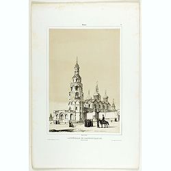
Moscou (Vue de la Basilique St. Basile).
View of the St. Basil Basilica in Moscow. Engraved by Rouargue.Also called the Cathedral of Saint Basil the Blessed, this basilica is a multi-tented church on the Red Squ...
Date: Paris, 1842
Selling price: ????
Please login to see price!
Sold in 2009

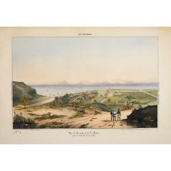
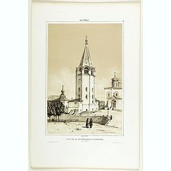
St. Pétersbourg.
View of St. Petersburg during winter time, with in background St Isaac's Square with Saint Isaac's Cathedral or Isaakievskiy Sobor. It was the largest cathedral (sobor) i...
Date: Paris, 1842
Selling price: ????
Please login to see price!
Sold in 2009

Die Rechtsverhandlung. The consultation.
Steel engraving of a man consulting a woman, by the master engraver A.H. Payne after a painting by Chr. Paudiss.Albert Henry Payne (born in London on December 14, 1812, d...
Date: Leipzig, 1842
Selling price: ????
Please login to see price!
Sold in 2013
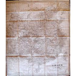
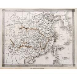
Carte de la Chine.
Rare, incredibly detailed map of China prepared by the renowned German historian, linguist, orientalist, and explorer Julius Klaproth. Originally intended to accompany Kl...
Date: Paris, 1842
Selling price: ????
Please login to see price!
Sold

Le Soldat du Chene, an Osage Chief.
A beautifully defined lithograph of "Le Soldat du Chene, an Osage Chief " from McKenney & Hall’s History of the Indian Tribes, perhaps the most important ...
Date: Philadelphia, circa 1836-1842
Selling price: ????
Please login to see price!
Sold in 2011
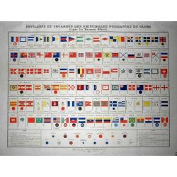
Pavillons et cocardes des principales puissances du globe d'après des Documents Officiels
Rare sheet with images of flags and rosettes of all sea fearing nations, from France to Russia, Turkey, and even Peru. Prepared by J. Andriveau-Goujon, published in his &...
Date: Paris, 1842
Selling price: ????
Please login to see price!
Sold in 2011
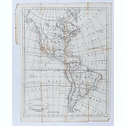
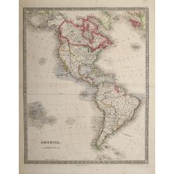
America.
Taken from "Atlas ethnographique du globe, ou classification des peuples anciens et modernes d'après leurs langues."
Date: Livorno, ca. 1842
Selling price: ????
Please login to see price!
Sold in 2020
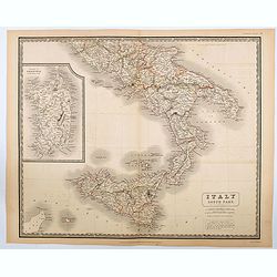
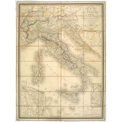
Italy South Part.
An attractive large map showing the Southern part of Italy including the islands of Sicily and Sardinia. Published in Edinburgh in Johnson's National Atlas..Nice detail, ...
Date: Edinburgh, 1842
Selling price: ????
Please login to see price!
Sold in 2020
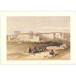
Ruins of Baalbec. May 5th, 1839.
Roberts was the first independent, professional British artist to travel so extensively in the Near East. His tour in 1838-9 produced 272 sketches, a panorama of Cairo an...
Date: London: F.G. Moon. 1842
Selling price: ????
Please login to see price!
Sold in 2023
![Baalbec [The Sanctuary, 4th-5th May, 1839].](/uploads/cache/1126552-250x250.jpg)
Baalbec [The Sanctuary, 4th-5th May, 1839].
Baalbek is a town in the Beqaa Valley of Lebanon situated east of the Litani River. After Alexander the Great conquered the Near East in 334 BC, the existing settlement w...
Date: London: F.G. Moon. 1842
Selling price: ????
Please login to see price!
Sold in 2023
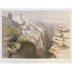
Convent of St. Saba April 4th 1839. / Engedi.
Dramatic view overlooking the Greek Orthodox Convent or Monastery of St. Saba near Bethlehem. Roberts was the first independent, professional British artist to travel ...
Date: London: F.G. Moon. 1842-9 1842
Selling price: ????
Please login to see price!
Sold in 2023
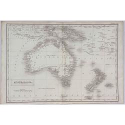
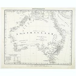
Australasia.
A detailed map of Australasia from Sidney Hall's scarce 1843 "New General Atlas”. Adam & Charles Black were among the leading publishers of atlases and travel ...
Date: London, 1843
Selling price: ????
Please login to see price!
Sold in 2021
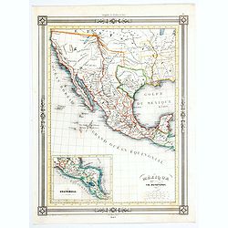
Mexique.
An uncommon map of Mexico from the French geographer Duvotenay, published in his many editioned Atlas Illustre.Cartographically, it shows Texas as a republic and depicts ...
Date: Paris, 1843
Selling price: ????
Please login to see price!
Sold in 2020
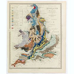
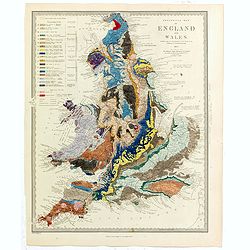
Geological Map of England and Wales . . .
Fascinating geological map of England and Wales, hand colored to reflect 20 different geological regions, with a color code on the left side of the plate.The map was prep...
Date: London, 1843
Selling price: ????
Please login to see price!
Sold in 2022
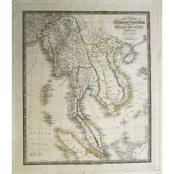
Map of the Burman Empire including also Siam, Cochin-China,Ton-King and Malaya from Calcutta to Hong Kong.
Superb map showing South East Asia, from Calcutta to Hong Kong. Includes many regions and place names such as the Burman Empire, Siam (Thailand), Cochin China and Tonking...
Date: London, c1843
Selling price: ????
Please login to see price!
Sold in 2012
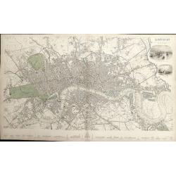
London.
A detailed plan of London, from Kensington to the East India Docks and Battersea to Holloway. Decorated with two vignettes of the Tower of London and a view of St.Paul's....
Date: London, 1843
Selling price: ????
Please login to see price!
Sold in 2012
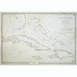
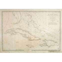
Carte des Grandes Antilles (Cuba, Haïti, Jamaïque, Archipel de Bahama..
Decorative focused on the Greater Antilles. Showing towns, banks, isles and soundings made in meters.Relief shown by hachures. Prepared by M. Keller, hydrographer and en...
Date: Paris, 1843
Selling price: ????
Please login to see price!
Sold in 2012
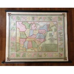
Mitchell's National Map of the American Republic or United States of North America Together with Maps of the Vicinities of Thirty -Two of the Principal Cities and Towns in the Union
Mitchell's National Map of the American Republic or United States of North America drawn by J.H. Young and engraved by J.H. Brightly. Map extends into the eastern part of...
Date: 1843
Selling price: ????
Please login to see price!
Sold in 2013
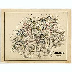
Schweiz gezeichnet von G.Asbach.
Fine manuscript map of Switzerland.
Date: Germany, ca. 1843
Selling price: ????
Please login to see price!
Sold in 2018
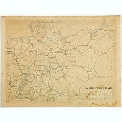
Kaiserreich Deutschland.
Fine manuscript map of The German Empire, which was the historical German nation state that existed from the unification of Germany in 1871 to the abdication of Kaiser Wi...
Date: Germany, ca. 1843
Selling price: ????
Please login to see price!
Sold in 2018

Pehriska-Ruhpa.
Aquatint from: 'Reise in das innere Nord-America in den Jahren 1832 - 1834' by Prince Maximilian of Wied-Neuwied, after paintings by Karl Bodmer, engraved by Paul Legrand...
Date: Paris, 1837-1843
Selling price: ????
Please login to see price!
Sold in 2015
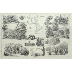
America.
Interesting sheet with a small map of the Americas surrounded by scenes and important places. From Wilhelm Penn with Indians; the Niagra Falls; Battle of Bunker Hill; vie...
Date: Stuttgart, ca. 1843
Selling price: ????
Please login to see price!
Sold in 2015
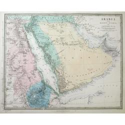
Arabia with Egypt, Nubia and Abyssinia...
A detailed steel-engraved map of the area from Egypt and Nile - West to the Persian Gulf and Gulf of Oman in the East.Several towns, cities, rivers, tribes, routes, and d...
Date: London, 1843
Selling price: ????
Please login to see price!
Sold in 2016
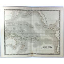
Islands in the Pacific Basin
A detailed map of islands in the Pacific Ocean with relief shown by hatchures. Centred on Hawaii., includes New Zealand, Australia, Japan etc. A decorative 'Piano Key' bo...
Date: Edinburgh, 1843
Selling price: ????
Please login to see price!
Sold in 2018
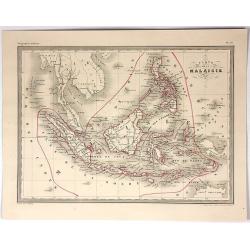
Carte de la Malaisie.
Fine lithographed map of South East Asia by A Vuillemin. Includes Malaysia, the Philippines, Indonesia, Singapore and Java. It is from the atlas "GEOGRAPHIE MODERNE&...
Date: Paris , 1843
Selling price: ????
Please login to see price!
Sold in 2017
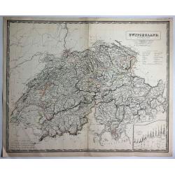
Switzerland (Die Schweiz ; La Suisse)
Large striking map of Switzerland by W & A.K. Johnston in Edinburgh in 1843. It definitely shows the high level of mountains in the country. It features an insert of ...
Date: Edinburgh, 1843
Selling price: ????
Please login to see price!
Sold in 2017
China.
A highly detailed map of China, extending from Tibet until South Korea. Names many towns, areas, rivers, islands,... Includes a tip of Japan and the Philippines.
Date: London, ca. 1843
Selling price: ????
Please login to see price!
Sold in 2017
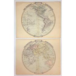
The Western & Eastern Hemispheres (Two Circular Maps).
George Frederick Cruchley (1797-1880) was a London based book and map seller, active in the middle part of the 19th century. He began his cartographic career as an appren...
Date: London, 1843
Selling price: ????
Please login to see price!
Sold in 2021
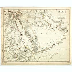
Arabia with Egypt, Nubia and Abyssinia . . .
Engraved map of Arabia peninsula. Detailed map of the area from Egypt and Nile West to the Persian Gulf and Gulf of Oman in the East and the Somali Coast in the south. Se...
Date: London, ca. 1843
Selling price: ????
Please login to see price!
Sold
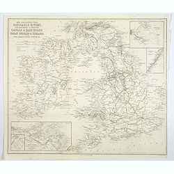
Map Exhibiting the Navigable Rivers, the completed & proposed Canals, & Rail-Roads of Great Britain & Ireland. . .
A large folded map of the navigable rivers, plus the existing or proposed canals and railways of G.B. & Ireland, originally published in London, but this example is p...
Date: New York, 1843
Selling price: ????
Please login to see price!
Sold in 2019
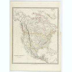
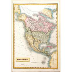
North America.
A detailed map of North America, published by Charles Knight in London for the S.D.U.K. Country borders are in different outline colors, TX is seen as a republic. Map ext...
Date: London ca 1843
Selling price: ????
Please login to see price!
Sold in 2019
Geological Map of England and Wales . . .
Fascinating geological map of England and Wales.
Date: London, 1843
Selling price: ????
Please login to see price!
Sold in 2020
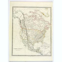
North America.
A detailed map of North America, published by Charles Knight in London for the S.D.U.K. Country borders are in different outline colors, TX is seen as a republic. Map ext...
Date: London ca 1843
Selling price: ????
Please login to see price!
Sold in 2019
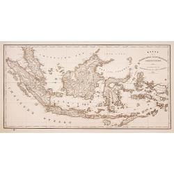
Kaart van Nederlands Oostindische bezittingen.
Detailed lithographed map of Indonesia published by ''Maatschappij tot nut van 't algemeen''. Lithographed and published by Daniel Veelwaard.
Date: Amsterdam 1843
Selling price: ????
Please login to see price!
Sold
Ile Bourbon - Vue de la rade et de St. Denis. . .
Very rare lithography representing a view of Saint-Denis de la Réunion. Plate N° 5.From Souvenirs d\'un voyage dans l\'Inde, exécuté de 1834 à 1839, by A. Delessert....
Date: Paris, 1843
Selling price: ????
Please login to see price!
Sold in 2009

Presqu'ile de Malacca.. - Vue de George Town, prise de la Moutagne des siguaux. Ile du Prince de Galles (Pulo-Pinang).
Lithography representing a view of George Town on Pinang island. Plate N° 10.From Souvenirs d'un voyage dans l'Inde, exécuté de 1834 à 1839, by A. Delessert.Adolphe D...
Date: Paris, 1843
Selling price: ????
Please login to see price!
Sold in 2008

Pondichery - Vue de la Maison du Port et de la rade de Pondichery. . .
Lithography representing a view of Pondicherry. Plate 9. From Souvenirs d'un voyage dans l'Inde, execute de 1834 à 1839, after a design by A. Delessert. Adolphe Delesser...
Date: Paris, 1843
Selling price: ????
Please login to see price!
Sold

Madras. - Scottch - Church.
Lithography representing a view of a Scottish church in Madras. Plate N 13. From Souvenirs d'un voyage dans l'Inde, execute de 1834 a 1839, by A. Delessert.Adolphe Deless...
Date: Paris, 1843
Selling price: ????
Please login to see price!
Sold
Plan de la Baie de Rio-Janeiro..
A detailed chart of the Rio de Janeiro bay with towns, buildings, banks, isles and soundings made in brasses a French measure of depth of water corresponding to the fatho...
Date: Paris [1829] 1843
Selling price: ????
Please login to see price!
Sold in 2008
Carte des Grandes Antilles (Cuba, Haïti, Jamaïque, Archipel de Bahama..
Decorative focused on the Greater Antilles. Showing towns, banks, isles and soundings made in metres.Relief shown by hachures. Prepared by M. Keller, hydrographer and en...
Date: Paris, 1843
Selling price: ????
Please login to see price!
Sold in 2018

Hôtel-de-ville de Gand
Beautiful hand-colored lithograph of the Ghent city hall, by Gustave Adolphe Simonau.One of Europe's greatest nineteenth century architectural artists, Gustave Adolphe Si...
Date: Brussels, 1843
Selling price: ????
Please login to see price!
Sold in 2009
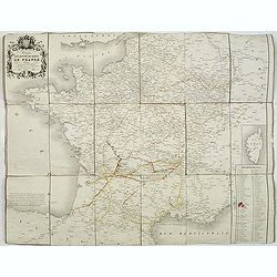
Carte des routes de poste de France dressée par ordre de Mr Conte, Conseiler d'Etat Directeur de l'administration et Président du conseil des Postes.
This post road maps map of France is showing incredible detail of the postal roads, stations (or "stages"), and the distances from town to town. Lower right, a ...
Date: Paris, 1843
Selling price: ????
Please login to see price!
Sold
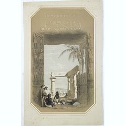
(Title page) Views on the Nile from Cairo to the second cataract.
Title page drawn on stone by George Moore, from sketches taken in 1832 and 1833 by Owen Jones and the late Jules Goury.The 19th-century Egyptian revival in Britain develo...
Date: London, Graves and Warmsley, 1843
Selling price: ????
Please login to see price!
Sold in 2021
Jerusalem from the road leading to Bethany.
A fine example from David Roberts' monumental works on the Middle East: The Holy Land and Egypt & Nubia, considered the greatest lithographically illustrated works is...
Date: London 1841-1844
Selling price: ????
Please login to see price!
Sold

Citadel of Jerusalem.
A fine example from the deluxe issue of David Roberts' monumental works on the Middle East: The Holy Land and Egypt & Nubia, considered the greatest lithographically ...
Date: London, 1841-1844
Selling price: ????
Please login to see price!
Sold

Mosque of Omar showing the site of the Temple.
A fine example of David Roberts' monumental works on the Middle East: The Holy Land and Egypt & Nubia, considered the greatest lithographically illustrated works issu...
Date: London 1841-1844
Selling price: ????
Please login to see price!
Sold

The Church of the Purification.
A fine example from David Roberts' monumental works on the Middle East: The Holy Land and Egypt & Nubia, considered the greatest lithographically illustrated works is...
Date: London 1841-1844
Selling price: ????
Please login to see price!
Sold

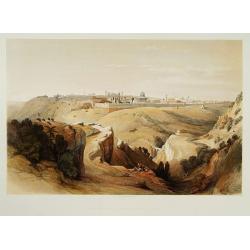
Jerusalem from the mount of Olives.
A fine example from David Roberts' monumental works on the Middle East: The Holy Land and Egypt & Nubia, considered the greatest lithographically illustrated works is...
Date: London 1841-1844
Selling price: ????
Please login to see price!
Sold
![Australien. / Australland. [2 maps]](/uploads/cache/12646-(1)-250x250.jpg)
Australien. / Australland. [2 maps]
Detailed map of Australia. With index to the different ,colonies, with number of inhabitants and size.Lithography by A.Theimert and printed by C.Flemming. Border lines ar...
Date: Glogau, 1844
Selling price: ????
Please login to see price!
Sold in 2011

Plan von St. Petersburg.
Bird's-eye view of St. Petersburg with 18 engraved vignettes of buildings throughout the great city. The map and bridge view are from the 1834 map by the Society for the ...
Date: Amsterdam, Paris, and Philadelphia, 1844
Selling price: ????
Please login to see price!
Sold
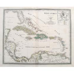
Carte de la Mer des Antilles - Partie Occidentale. . .
Decorative focused on the western part of the Caribbean Sea.Showing towns, banks, isles and soundings indicated in metres. Relief shown by hachures.Engraved by Chassant....
Date: Paris, 1844
Selling price: ????
Please login to see price!
Sold in 2020

Palais de Paul 1er. Côté du Jardin d'Eté. (16 Juillet 1839).
A view of Paul the First Palace in Saint Petersburg on August 9 1839. Figures are lithographed by Raffet. Plate taken from the first illustrated account of Russian archit...
Date: Paris, 1844
Selling price: ????
Please login to see price!
Sold in 2025
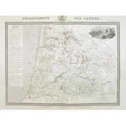
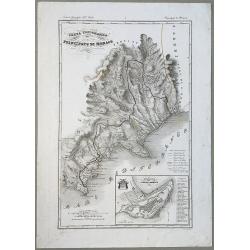
Département des Landes.
Detailed map of the Landes, with Bayonne in lower left corner. A panoramic view of Mont-de-Marsan upper right.. Text column of a detailed description of the geography, hi...
Date: Paris, 1844
Selling price: ????
Please login to see price!
Sold

A pair of English 3-inch globes.
With pasted label on each globe with the complete titles on each : - MALBY'S Terrestrial Globe Compiled from the GLOBES of the SOCIETY FOR THE DIFF[?]. OF USEF[??] KNOWLE...
Date: London, 1844
Selling price: ????
Please login to see price!
Sold in 2016
Australland.
Detailed map of Australia. With index to the different colonies in 1841, with number of inhabitants and size.Lithography by A.Theimert and printed by C.Flemming.
Date: Glogau, 1844
Selling price: ????
Please login to see price!
Sold in 2011
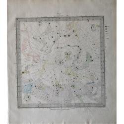
Set of six S.D.U.K celestial charts.
The complete set of six sequentially numbered steel engraved celestial charts, designed by W Clarke after W Newton, and engraved by John & Charles Walker; Published b...
Date: London, 1844
Selling price: ????
Please login to see price!
Sold in 2020
![[Title page] Voyage pittoresque et archaéologique en Russie.](/uploads/cache/43490-250x250.jpg)
[Title page] Voyage pittoresque et archaéologique en Russie.
Title page of "Voyage pittoresque et archaéologique en Russie" with two joined pages. The first is a letter for a certain "Mathilde" from Anatole Dé...
Date: Paris, 1844
Selling price: ????
Please login to see price!
Sold in 2021
Carta Topografica del Principato Di Monaco.
A map of the Princedom of Monaco. Nice 19th Century map with insert at lower right: 'Topografia della Città Di Monaco', with legend 1-30. Original border-colored. From: ...
Date: Florence, 1844
Selling price: ????
Please login to see price!
Sold in 2020
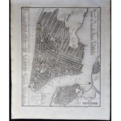
Plan von New-York 1844.
A detailed map of New York (Manhattan, Williamsburg, Brooklyn), based upon the work of Tanner, with a key naming around 200 prominent places and buildings (churches, hote...
Date: Leipzig, 1844
Selling price: ????
Please login to see price!
Sold in 2020
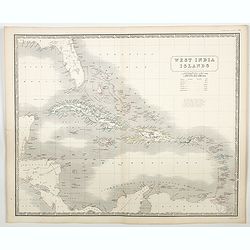
West India Islands.
A large-scale map of Florida, and the Caribbean, while also showing portions of Yucatan, Honduras, Guatemala, Panama, Cartagena and Venezuela, courtesy of the Johnston pu...
Date: Edinburgh, ca 1844
Selling price: ????
Please login to see price!
Sold in 2023
America.
Engraved, with colored margins of countries. Shows place names, roads, rivers, lakes, and islands. Relief shown with hachures. British possessions shown in red (Jamaica, ...
Date: London, 1844
Selling price: ????
Please login to see price!
Sold in 2013
North America.
This interesting transition map features Alaska as a part of Russia, California and Texas as a part of Mexico and Canada still "British Territories". Sidney H...
Date: London, 1844
Selling price: ????
Please login to see price!
Sold in 2013

Western Siberia, Independent Tartary , Khivam, Bokhara, etc.
Detailed map of a little explored region of Russia. From the Russian Lapland to Bokhara and from the Caspian Sea to Yeniseisk. Insert Maps of nova Zemblia and Yeniseisk....
Date: London, 1844
Selling price: ????
Please login to see price!
Sold in 2014
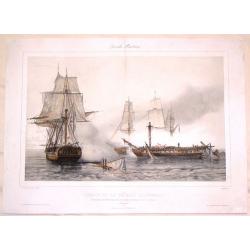
Combat de la Fregate la Pomone.
Fine tinted lithograph of a famous naval battle. Lithographed by A. Lemercier after a painting by Henri Durand-Brager. Jean-Baptiste Henri Durand-Brager, (1814 – 1879),...
Date: Paris, 1844
Selling price: ????
Please login to see price!
Sold in 2016

Orlando, 1844 winner of the derby stakes at Epsom...../ The princess, 1844 winner of the oaks stakes at Epsom....
Representation of two Horses, winner of a derby.
Date: London, 1844
Selling price: ????
Please login to see price!
Sold in 2014

Cafres / Autruches
Two engraving for one sheet. Engraving depict typical warriors of Africa and Ostrich.
Date: Paris,1844
Selling price: ????
Please login to see price!
Sold in 2015
Carte routiére d'Italie indiquant les divisions politiques de ses divers états . . .
Scarce folding map of Italy, Switzerland and Austria. In lower right inset plan "Route de Lyon à Marseille conduisant à celle de Nice." and "Routes de Pa...
Date: Paris, 1844
Selling price: ????
Please login to see price!
Sold in 2023
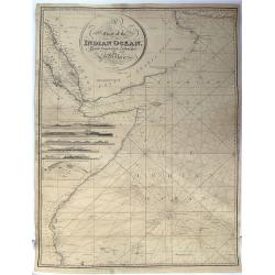
A Chart Of The Indian Ocean Drawn From The Best Authorities.
This detailed sea chart by John William Norie features the Western Indian Ocean and east coast of Africa, from Cape Delgado in the south to Persian Gulf in the north. T...
Date: London, 1844
Selling price: ????
Please login to see price!
Sold in 2015
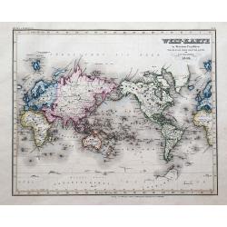
Welt-Karte in Mercators Projektion.
An attractive German map of the World centred on the Pacific Ocean. Australia is still 'Neu Holland' and Alaska is 'Russisches America'. Several pieces of coasts of Antar...
Date: Hildburghausen, 1844
Selling price: ????
Please login to see price!
Sold in 2016

Tiger Island. Entrance of the Canton River.
A superb view of the mouth of the Pearl River, near Guangzhou and Hong Kong. With three very detailed boats and ships shown.Engraved by Goodall, drawn by Standfield, sket...
Date: London, 1844
Selling price: ????
Please login to see price!
Sold in 2017
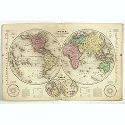
Olney's School Atlas.
Olneys' popular atlas with 23 maps including several related to the United States as well as maps of the world and continents.The double hemisphere world map includes qua...
Date: New York, 1844
Selling price: ????
Please login to see price!
Sold in 2017
WEST INDIEN.
A large map of Florida, the Bahamas, the Caribbean Islands, and parts of Central America and South America.Highly detailed with many place names given. colors indicate th...
Date: Weimar, 1844
Selling price: ????
Please login to see price!
Sold in 2018
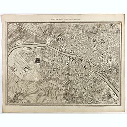
Plan de Paris Par Roussel Caqpt. Ingénieur en 1700.
Plan of the center of Paris by Claude Roussel (1655-172.?). here in a later reprint from around 1844.
Date: Paris, after or ca. 1844
Selling price: ????
Please login to see price!
Sold
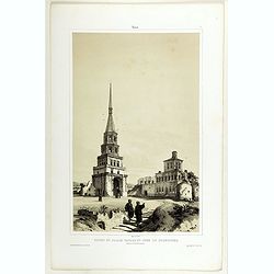
Entrée Méridionale et Tour dite des Saints.
A view of Troïtza Monastery near Moscow. Raffet lithographs figures. Plate taken from the first illustrated account of Russian architecture. This publication was the pro...
Date: Paris, 1844
Selling price: ????
Please login to see price!
Sold
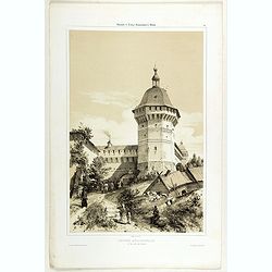
Ruines du Palais Tartare et Tour de Soumbecka intérieur de la Forteresse.
A view of the Tartar Palace's ruins and Soumbecka's tower in Kazan in southwest Russia, on the banks of the Volga and Kazanka rivers. Figures are lithographed by Raffet. ...
Date: Paris, 1844
Selling price: ????
Please login to see price!
Sold in 2019
Cathédrale de l'Annonciation ( Blakovestchensky).
A view of l'Annonciation cathedral. Figures are lithographed by Raffet. Plate taken from the first illustrated account of Russian architecture. This publication was the p...
Date: Paris, 1844
Selling price: ????
Please login to see price!
Sold in 2019
Tour de la Cathédrale d'Ouspensky.
A view of Ouspensky's cathedral. Figures are lithographed by Raffet. Plate taken from the first illustrated account of Russian architecture. This publication was the proj...
Date: Paris, 1844
Selling price: ????
Please login to see price!
Sold
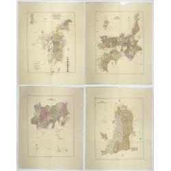
Nippon io tsi ko Tei sen-Tsu.
Four geographical maps of the islands of Japan entitled: Nippon io tsi ko Tei sen-Tsu. . These charts include 3 large islands of Japan: NIPPON, KIOUSIOU and SIKOKF with t...
Date: Japon, 1844
Selling price: ????
Please login to see price!
Sold in 2020
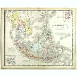
S.E. Peninsula and Malaysia.
Very detailed map of South-east Asia with Philippines, Malaysia, Formosa (Taiwan) by A.K. Johnston's.Inset maps of "Island and Strait of Singapore. Properly Singhapu...
Date: London, Edward Stanford, ca. 1844
Selling price: ????
Please login to see price!
Sold in 2020