Browse Listings
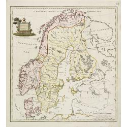
Present Sweden & Norway.
Charming map of Scandinavia, with some detail in Sweden, Norway and Finland. Engraved by Samuel John Neele. (1758-1824) and published by Thomas Stackhouse (1756-1836)
Date: London, T.Stackhouse, 1790
Selling price: ????
Please login to see price!
Sold in 2010
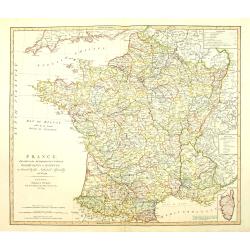
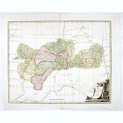
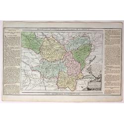
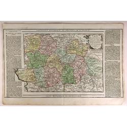
France divided into Metropolitan circles departments & districts.
Map of France with an inset of Corsica in the same scale. William Faden (1750?-1836) was Geographer to His Majesty and to H.R.H. the Prince of Wales.
Date: London, 1790
Selling price: ????
Please login to see price!
Sold in 2010
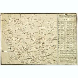
Carte des marches du quartier générale de l'Armée Rusienne fait sous le Commandement de S.E. Le Feld Marechal Comte de Butturlin. . .
Manuscript map of Poland showing the campaign of Marshal Butterlin in 1761 at the conclusion of the "Seven-year's War" (1756 - 1763). To the right an almost dai...
Date: France, c.1761-1790
Selling price: ????
Please login to see price!
Sold in 2014
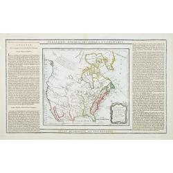
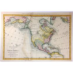
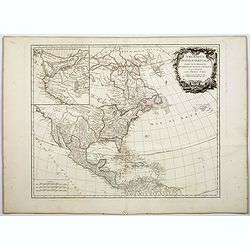
Nouveau Mexique, Louisiane, Canada. . .
Map showing United States and Canada. Left and right a box with geographical information for each part country on the continent.Prepared by Louis Brion de la Tour and pub...
Date: Paris, 1790
Selling price: ????
Please login to see price!
Sold in 2016
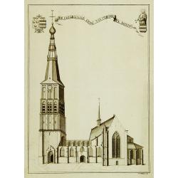
De collegiaale kerk van St.Pieter te Boxtel.
Rare print of St. Pieter church in Boxtel.
Date: Netherlands, c.1790
Selling price: ????
Please login to see price!
Sold in 2011
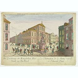
La destruction de la Statue royale a Nouvelle York.
One of the few European prints dealing with the Revolutionary war.J. Chereau was a publisher of optical prints, established in Paris, rue St.Jacques. In the eighteenth an...
Date: Paris, 1790
Selling price: ????
Please login to see price!
Sold in 2012
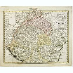
General Charte von Ungarn :mit seinem Nebenländern Croatien, Dalmatien, Slavonien und Siebenbürgen, ingleichen Gallizien und der Bukowina nebst. . .
Map of Hungary prepared by F. L. Güssefeld and published by Homann Heirs. Engraved by I. Rausch.
Date: Nuremberg, 1790
Selling price: ????
Please login to see price!
Sold in 2012
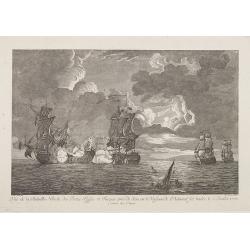
Vue de la Bataille Navale des Flottes Russes et Turques . . .
Very decorative engraving of a battle between Russian and Turkish men-of-war on July 5th, 1770. After a painting of Franc Swain.
Date: Augsburg, 1790
Selling price: ????
Please login to see price!
Sold in 2016
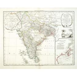
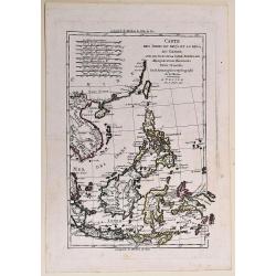
Presqu 'Isle Des Indes Orientales,..
Detailed map of India with inset map (220x155mm) of the entree of the river Ganges. With decorative scene with an elephant underneath the title cartouche.
Date: Paris, 1790
Selling price: ????
Please login to see price!
Sold in 2012

Uomai, nativo di Ulaietea condotto in Inghilterra nell' anno 1774 da Tobia Furneaux, Gentiluomo Inglese. / Omai, natif d'Ulaietea Conduit en Angleterre dans l'an 1774 par Tobie Furneaux, Gentilhomme Anglois.
Full portrait of an Omai, a Native of Ulaietea, was brought into England in 1774 by Tobias Furneaux. Probably based on a drawing by Nathaniel Dance Holland (1734-1811).A ...
Date: Venice, Antonio Zatta, c.1790
Selling price: ????
Please login to see price!
Sold in 2012
![[No tittle - With Russian text] Poland and the Baltic Sea.](/uploads/cache/31405-250x250.jpg)
[No tittle - With Russian text] Poland and the Baltic Sea.
Detailed map of Poland after Rizzi-Zanoni's map of 1783 here in Russian. The map was prepared by the Italian astronomer, geographer and cartographer Giovanni Antonio Rizz...
Date: mperial Academy of St. Petersburg, ca. 1790
Selling price: ????
Please login to see price!
Sold in 2012
Terre de Kerguelen Appellee par M. Cook, Isle de la Desolation.
Interesting copper engraved map of the Kerguelen Islands including Plan du Havre de Noel, & Plan du Port Palliser.BONNE, RIGOBERT (1729-1795). Bonne was “Royal Hydr...
Date: Paris, 1790
Selling price: ????
Please login to see price!
Sold in 2015
Plan de Kronstadt.
Map shows a city map of Kronstadt.
Date: Paris, 1790
Selling price: ????
Please login to see price!
Sold in 2014

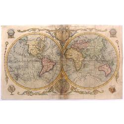
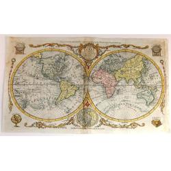
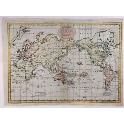
Hémisphére Occidental.
Map of Western hemisphere.Left and right a box with geographical information for spheres of different types.Prepared by Louis Brion de la Tour and published by Louis Char...
Date: Paris, 1790
Selling price: ????
Please login to see price!
Sold in 2020
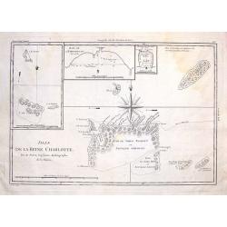
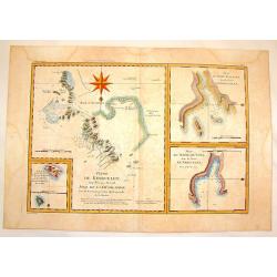
Isles de la Reine Charlotte.
These are the Santa Cruz Islands now, near the Solomon Islands. There are three inserts including the islands of Carteret, Hirondelle and bay of Byron. The centered overs...
Date: Paris, 1790
Selling price: ????
Please login to see price!
Sold in 2014
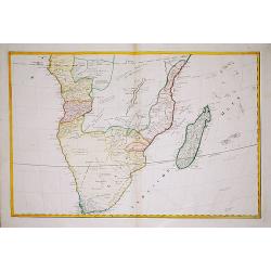
(Map of South Africa)
A large map of South Africa, engraved by Hieronymus Benedicti. Not in Norwich.
Date: Vienna, c. 1790
Selling price: ????
Please login to see price!
Sold in 2021
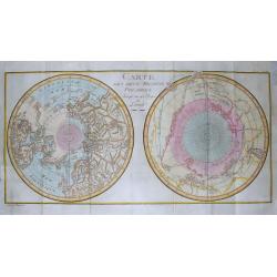
Carte Des Deux Regions Polaires...
Unusual map of the World on a polar projection, showing a contemporary knowledge of the Polar latitudes, including the routes of Abel Tasman, James Cook, Edmund Halley, F...
Date: Paris, c1790
Selling price: ????
Please login to see price!
Sold in 2014
L'Imperio Della Gran Russia.
Striking and highly detailed unusual copper engraved map of the European Russian empire. The map provides several topographic details concerning cities, towns, rivers, la...
Date: Paris, 1790
Selling price: ????
Please login to see price!
Sold in 2015
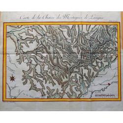
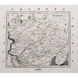
Carte de la Chaine des Montagnes de Langres.
Unusual map an area in North-East France, including the cities of Sens, Troyes, Bar-sur-Aube, Chaumont, Neufchateau, Langres, Gray, Besancon, Dijon, Auxerre. Great detail...
Date: Paris, c1790
Selling price: ????
Please login to see price!
Sold in 2015
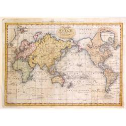
A New and Complete Chart of the World; Displaying the Tracks of Captain Cook and Other Modern Navigators.
Copperplate map on Mercator's projection featuring the recent discoveries in the Pacific and northern oceans. Specifically are updates on Alaska, The Sandwich Islands and...
Date: London, 1790
Selling price: ????
Please login to see price!
Sold in 2016
The World including the late Discoveries by Captain Cook and other Circomnavigators.
Striking double-hemisphere world map depicting the recent discoveries prior to 1790. Alaska is shown with a fairly correct shape. The Sandwich Islands are shown and note...
Date: London, 1790
Selling price: ????
Please login to see price!
Sold in 2015
To My Worthy and Learned Friend the Honourable Daines Barrington This Plan of two Attempts to Arrive at the Source of the Nile is dedicated by his most Obliged and faithful Humble Servant James Bruce.
This is a significant, engraved, 1790 map of Ethiopia (Abyssinia) and the source of the Blue Nile by the Scottish adventurer James Bruce. Centered on Lake Tana (Tzana), t...
Date: London, 1790
Selling price: ????
Please login to see price!
Sold in 2017
Nouvelle Carte Reduite, l'Archipel des Arsacides.
Interesting map of New Guinee, also called “Archipel des Iles de Salomon” from “Descouvertes des Francois au Sud-Est de la Nouvelle Guinee”. It was published in ...
Date: Paris, 1790
Selling price: ????
Please login to see price!
Sold in 2019
The World including the late Discoveries by Capt Cook and other Circumnavigators
Striking, double-hemisphere world map depicting the discoveries in the Pacific and northern oceans during the latter 18th century.Alaska is shown with a fairly correct sh...
Date: London, 1790
Selling price: ????
Please login to see price!
Sold in 2015

Vue Interieure de la Cathedrale de Dorth. (Dordrecht)
Optical view of an interior view of the Cathedral of Dordrecht. So-called Optical view enhanced by water colors. It was produced by Daumont in Paris in about 1790. The op...
Date: Paris, 1790
Selling price: ????
Please login to see price!
Sold in 2018
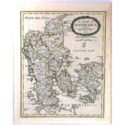
Il Regno Di Danimarca.
A rare map of Denmark, published by Pazzini Carli in Siena. Engraved by A. Borghi. With a lovely quaint, oval, floral, cartouche.
Date: Siena, 1790
Selling price: ????
Please login to see price!
Sold in 2018
A New & Accurate Map of North America: With the New Discovered Islands on the North East coast of Asia
This fine map focuses on the discoveries of Captain Cook in the Pacific Northwest and Alaska. Alaska is fairly well formed but misshapen, although much of the Aleutian Is...
Date: London, 1790
Selling price: ????
Please login to see price!
Sold in 2016
![[de Lafayette, full-length portrait] Conclusion de la campagne -- de 1781 en Virginie Liberté : To his Excellency General Washington this Likeness of his friend, the Marquess de la Fayette, is humbly dedicated, By le Mire. . .](/uploads/cache/36866-250x250.jpg)
[de Lafayette, full-length portrait] Conclusion de la campagne -- de 1781 en Virginie Liberté : To his Excellency General Washington this Likeness of his friend, the Marquess de la Fayette, is humbly dedicated, By le Mire. . .
Print shows Marquis de Lafayette, full-length portrait, standing, facing front, wearing a uniform, and holding two swords in the left hand while directing American troops...
Date: Paris, 1780 - 1790
Selling price: ????
Please login to see price!
Sold in 2016
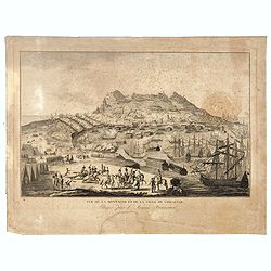
Vue de la Montagne et de la Ville de Gibraltar, attaquée par l'armée Française.
Showing the siege of Gibraltar by the French. The engraving has a numbered and lettered key but no explanation on the engraving itself. With N° 57 in upper right corner....
Date: Paris, ca. 1790
Selling price: ????
Please login to see price!
Sold in 2016
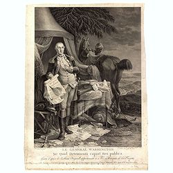
Le Général Washington ne quid detrimenti capiat res publica - gravé d'après le tableau original appartenant a Mr. Marquis de la Fayette. . .
Print shows George Washington, full-length portrait, standing outside tent, wearing military uniform, holding the Declaration of Independence and the treaty of alliance w...
Date: Paris, 1780 - 1790
Selling price: ????
Please login to see price!
Sold in 2016
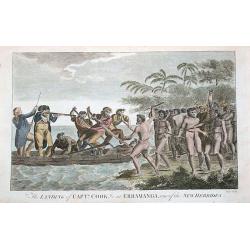
The landing of Captn. Cook, &c at Erramanga, one of the New Hebrides.
Copper engraved scene at Eromanga in the nation of today's Vanuatu during Cook's second voyage. Shows Captain Cook with his gun and his crew in a small boat fighting with...
Date: London, ca. 1790
Selling price: ????
Please login to see price!
Sold in 2016
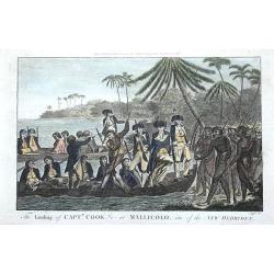
The landing of Captn. Cook, &c at Mallicolo, one of the New Hebrides.
Copper engraved scene on the island of Malakula in Vanuatu. Shows two of Captain Cooks boats with his crew landing on the island during Cook's second voyage. By Alexander...
Date: London, ca. 1790
Selling price: ????
Please login to see price!
Sold in 2016
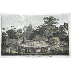
The Reception of Captn. Cook, in Hapaee.
The Ha'apai islands were named by Captain Cook the Friendly Islands, today's Tonga. Shown are a large group of Polynesians watching a boxing fight and a fight with clubs....
Date: London, ca. 1790
Selling price: ????
Please login to see price!
Sold in 2016
Mappa gubernii Orelensis.
Highly detailed rare map covering the area of the Oryol Oblast in Russia, south of Moscow.The map is a result of a new survey of Russia done in the first years of the rei...
Date: St Petersburg, 1750-1790
Selling price: ????
Please login to see price!
Sold in 2016
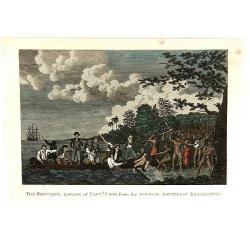
The fortunate Escape of Capt'n Cook from the Furious Natives of Erramango
A copper engraving featuring Captan Cook's escape from Erromango, "the land of Mangoes", one of the largest and least populated islands in Vanuatu.It was visite...
Date: London, ca. 1790
Selling price: ????
Please login to see price!
Sold in 2016
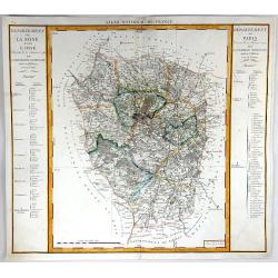
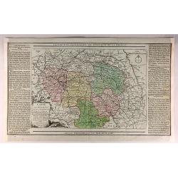
Departement de Paris & Departement de la Seine et de la L'Oise
A fine map featuring the area of France surrounding Paris. From the "Atlas National de France" by Pierre Dumez (1757-1794). The map has a detailed index on both...
Date: Paris, 1790
Selling price: ????
Please login to see price!
Sold in 2016
![[Map including Wroclaw and region].](/uploads/cache/38706-250x250.jpg)
[Map including Wroclaw and region].
A very detailed of region of Wroclaw (Breslau) from Roch Joseph Julien's "NOUVEAU THEATRE DE LA GUERRE OU ATLAS TOPOGRAPHIQUE ET MILITAIRE" published in 1758 in...
Date: 1790
Selling price: ????
Please login to see price!
Sold in 2016
Amerique Septentrionale. . .
An interesting, and important map by the French cartographer, Robert de Vaugondy. A map of the United States beginning in the High Arctic and Baffin Bay, and then southwa...
Date: Paris, ca 1790
Selling price: ????
Please login to see price!
Sold in 2018
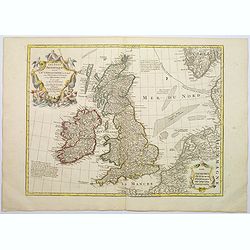
Les Isles Britanniques ou sont le Rme. D'Angleterre . . . Par G. De L'Isle. . . A Paris Chez Dezauche. . .
An uncommon, but attractive map of the British Isles. The bottom right shows the coasts of the Netherlands, Belgium, and northern France and at the upper right is the sou...
Date: Paris, c.1790
Selling price: ????
Please login to see price!
Sold in 2017
![SHVETZIJA I NORVEGIJA [russian Map !]](/uploads/cache/97961-250x250.jpg)
SHVETZIJA I NORVEGIJA [russian Map !]
A copperplate Russian map of Sweden, Norway and Finland with original outline coloring, ca 1790.
Date: St. Petersburg, 1790
Selling price: ????
Please login to see price!
Sold in 2019
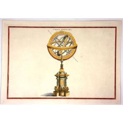
Sphaera Armillaris.
Fine example of a Ptolemaic armillary sphere. The central terrestrial globe (labeled Terra) is surrounded by Arctic and Antarctic circles, Cancer and Capricorn tropical c...
Date: London, ca. 1790
Selling price: ????
Please login to see price!
Sold in 2019
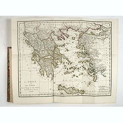
Recueil de Cartes Geographiques, Plans, Vues et Medailles de L'Ancienne Grece, Relatifs Au Voyage du Jeune Anacharsis, Precede d'une Analyse Critique des Cartes.
Great atlas of Ancient Greece, including many classical maps and battle plans. 31 copper engraved maps plans and plates with several hand colored in outline, many double ...
Date: Paris, 1790
Selling price: ????
Please login to see price!
Sold in 2017
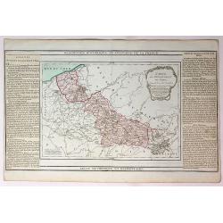
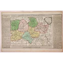
Carte du Departement du Nord.
An attractive map of the department of Nord in northern France by French cartographer, Louis Brion de la Tour. It notes numerous towns, cities, rivers, forests, mountains...
Date: Paris, 1790
Selling price: ????
Please login to see price!
Sold in 2017
Carte D'Austriche Divisee en Toutes ses Provinces...
An attractive and informative map of Austria by French cartographer, Louis Brion de la Tour. It notes numerous towns, cities, rivers, forests, mountains and other topogra...
Date: Paris, 1790
Selling price: ????
Please login to see price!
Sold in 2018
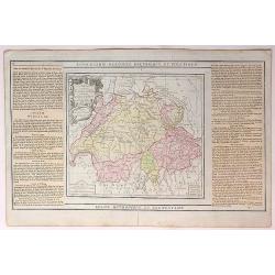
La Suisse Divisee en Toutes ses Cantons.
An attractive and informative map of Switzerland by French cartographer, Louis Brion de la Tour. It notes numerous towns, cities, rivers, forests, mountains and other top...
Date: Paris, 1790
Selling price: ????
Please login to see price!
Sold in 2018
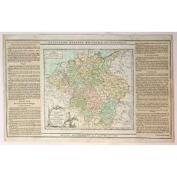
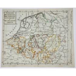
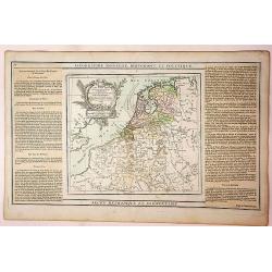
L'Alemagne Divisee en Tous ses Cercles...
An attractive and informative map of Germany by French cartographer, Louis Brion de la Tour. It notes numerous towns, cities, rivers, forests, mountains and other topogra...
Date: Paris, 1790
Selling price: ????
Please login to see price!
Sold in 2018
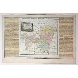
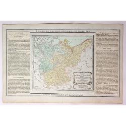
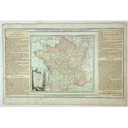
La France, Divisee en ses Quarante Gouvernemens Generaux et Militaires...
An attractive and informative map of France by French cartographer, Louis Brion de la Tour. It notes numerous towns, cities, rivers, forests, mountains and other topograp...
Date: Paris, 1790
Selling price: ????
Please login to see price!
Sold in 2019
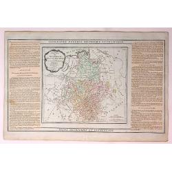
Cercles de Haute wt Basse Saxe,Divises en Toutes Leurs Principantes et Provinces...
An attractive and informative map of France by French cartographer, Louis Brion de la Tour. It notes numerous towns, cities, rivers, forests, mountains and other topograp...
Date: Paris, 1790
Selling price: ????
Please login to see price!
Sold in 2019
Cercles de Baviere de Franconie et de Souabe...
An attractive and informative map of France by French cartographer, Louis Brion de la Tour. It notes numerous towns, cities, rivers, forests, mountains and other topograp...
Date: Paris, 1790
Selling price: ????
Please login to see price!
Sold in 2018
Cercles de Westphalie Haut et Bas Rhin Divises en Toutes Leurs Principautes et Provinces...
An attractive and informative map of Westphalia by French cartographer, Louis Brion de la Tour. It notes numerous towns, cities, rivers, forests, mountains and other topo...
Date: Paris, 1790
Selling price: ????
Please login to see price!
Sold in 2019
Carte des Departemens de la Meuse, de la Moselle, de la Meurte, des Voges et du Bas Rhin...
An attractive and informative map of departments in France by French cartographer, Louis Brion de la Tour. It notes numerous towns, cities, rivers, forests, mountains and...
Date: Paris, 1790
Selling price: ????
Please login to see price!
Sold in 2018
Carte des Departemens de la Cote d'Or, de Daone et Loire, de la HauteSaone, du Doubs de Jura.....
An attractive and informative map of French departments by French cartographer, Louis Brion de la Tour. It notes numerous towns, cities, rivers, forests, mountains and ot...
Date: Paris, 1790
Selling price: ????
Please login to see price!
Sold in 2019
Quatrieme Age Depuis la Loy Ecrite ou la Sortie D'Egypte Jusqu'a la Dedicace du Temple de Salomon.
An attractive and informative map of the exit from Egypt, to the dedication of Solomon, by French cartographer, Louis Brion de la Tour. To the left and right of the map a...
Date: Paris, 1790
Selling price: ????
Please login to see price!
Sold in 2017
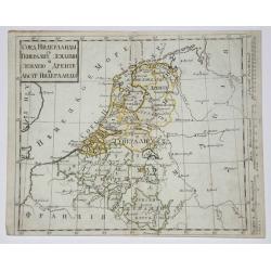
Belgium, Netherlands, Luxemburg.
Copperplate in Russian language of The Netherlands, Belgium and Luxembourg with original outline coloring. Part of Netherlands and Luxembourg are parts of Austria.
Date: St. Petersburg, 1790
Selling price: ????
Please login to see price!
Sold in 2017
West Germany & Belgium, Luxemburg.
Copperplate russian map of West Germany & Belgium, Luxemburg. with original outline coloring.
Date: St. Petersburg, 1790
Selling price: ????
Please login to see price!
Sold in 2017
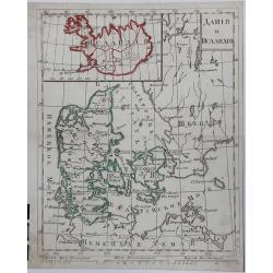
DANIJA I ISLANDIJA, (Russian map).
A copperplate Russian map of Denmark and Iceland, with original outline coloring, published in 1790.
Date: St. Petersburg, 1790
Selling price: ????
Please login to see price!
Sold in 2017
Die Markgrafschaft des heiligen römischen Reichs Antwerpen mit der Herrschaft Mecheln.
A detailed large scale map of the area with Antwerp, Lier, Herentals, Geel, Mol, Turnhouta, Hoogstraten, etc. Shows many small towns.
Date: Vienna, ca. 1790
Selling price: ????
Please login to see price!
Sold in 2018
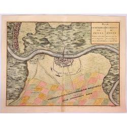
Plan van de Veldtslag van Zenta.
A map of the fortifications and surrounding area of troop orders during the battle of Senta in 1697, between the Imperial and Turkish troops .The birds-eye plan is from J...
Date: Paris, ca. 1790
Selling price: ????
Please login to see price!
Sold in 2018
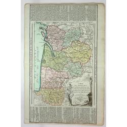
Carte des Departemens de la Mayenne, de la Sarte, D'Eure et Loire, de maine et Loire, d'Indre et de Loire....
An attractive and informative map of several provinces by French cartographer Louis Brion de la Tour. It notes numerous towns, cities, rivers, forests, mountains, and oth...
Date: Paris, 1790
Selling price: ????
Please login to see price!
Sold in 2019
Les Pays Bad Francois Autrichiens et Hollandois...
An attractive and informative map of Holland by French cartographer, Louis Brion de la Tour. It notes numerous towns, cities, rivers, forests, mountains and other topogra...
Date: Paris, 1790
Selling price: ????
Please login to see price!
Sold in 2018
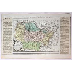
Carte des Departemens de la Charente Inferieure, de la Charente, de la Gironde, de la Dordogne, des Landes, du Lot et Garonne et des Baffes Pyrenees...
An attractive and informative map several French Provinces by French cartographer, Louis Brion de la Tour. It notes numerous towns, cities, rivers, forests, mountains an...
Date: Paris, 1790
Selling price: ????
Please login to see price!
Sold in 2019
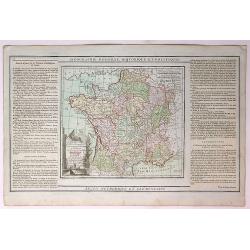
La France Divisee en ses Quarante Gouvernemens Generaux et Militaires...
An attractive and informative map of the governmental and military parts of France by French cartographer, Louis Brion de la Tour. It notes numerous towns, cities, rivers...
Date: Paris, 1790
Selling price: ????
Please login to see price!
Sold in 2018
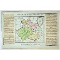
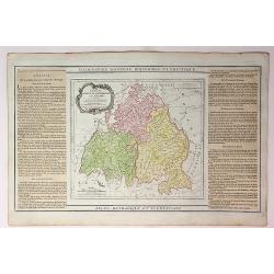
Etats de Boheme Divisee en Toutes Leurs Provinces...
An attractive and informative map of the Bohemian part of Germany by French cartographer, Louis Brion de la Tour. It notes numerous towns, cities, rivers, forests, mounta...
Date: Paris, 1790
Selling price: ????
Please login to see price!
Sold in 2019
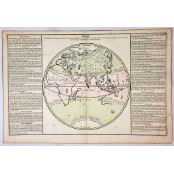
Zones.
A circular map of the Eastern Hemisphere, depicting the zones of the earth, including Torid, Temper and Glacial.To the left and right of the map is French text with remar...
Date: Paris, 1790
Selling price: ????
Please login to see price!
Sold in 2018
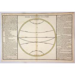
Division Astronomique de la Terre.
An empty circular map of a hemisphere depicting the equator and zones including Tropic, Cancer, Tropic and Capricorn. To the left and right of the map is French text with...
Date: Paris, 1790
Selling price: ????
Please login to see price!
Sold in 2018
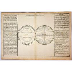
De la Longitude et de la Latitude.
Two empty circular maps of hemispheres depicting the Longitude and Latitude. To the left and right of the map is French text with remarks and descriptions of the map. It ...
Date: Paris, 1790
Selling price: ????
Please login to see price!
Sold in 2018
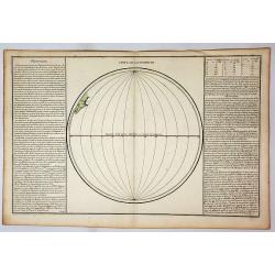
Suite de Longitude.
A circular map depicting the Equator and lines of Longitude. To the left and right of the map is French text with remarks and descriptions of the map. It is from “Geogr...
Date: Paris, 1790
Selling price: ????
Please login to see price!
Sold in 2019
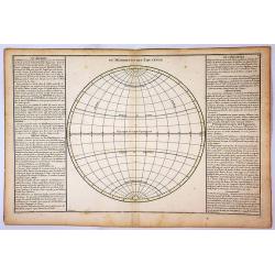
Du Meridien et de L'Equateur.
A circular map depicting the Equator and Tropic of Cancer and Capricorn. To the left and right of the map is French text with remarks and descriptions of the map. It is f...
Date: Paris, 1790
Selling price: ????
Please login to see price!
Sold in 2018
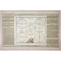
Lecon Methodique et Elementaire.
Five circular maps showing the position of various people on the earth. The map features a vignette at the centre bottom. To the left and right of the map is French text ...
Date: Paris, 1790
Selling price: ????
Please login to see price!
Sold in 2018
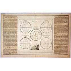
Position Respective des Peuples de la Terre.
Five circular maps showing the position of various people on the earth. The map features a vignette at the centre bottom. To the left and right of the map is French text ...
Date: Paris, 1790
Selling price: ????
Please login to see price!
Sold in 2019
Carte des Departemens de Paris, de la Seine et de l'Oise de la Marne.
A striking 1790 map featuring parts of the Ile-de-France, Champagne-Ardenne and Bourgogne regions of France, including Paris, by the French cartographer Louis Brion de la...
Date: Paris, 1790
Selling price: ????
Please login to see price!
Sold in 2018
Carte des Departemens de la Mayenne, de la Sarte, de Maine et Loire, D'indre et Loir...
This is a lovely 1790 map of the Pays de la Loire, Center, Poitou-Charentes, and Bourgogne regions of France by the French cartographer Louis Brion de la Tour. It covers ...
Date: Paris, 1790
Selling price: ????
Please login to see price!
Sold in 2019
Carte des Indes en deça et au delà du Gange. . .
A copper engraved map.
Date: Venise, 1790
Selling price: ????
Please login to see price!
Sold in 2017

Chart of Cook's Strait in New Zealand.
An early and important map of Cook's Strait, which separates the North and South islands of New Zealand. Shows the area of present day Wellington, Marlborough Sounds, and...
Date: London, ca. 1790
Selling price: ????
Please login to see price!
Sold in 2017
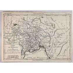
Carte du Bengale avec la Partie Septentrionale des Etats du Roi D'Aua.
A detailed eighteenth century map of Bengal, India with Calcutta prominently marked, and the Ganges up to Patna, and that part which is modern Bangladesh. From Brunet's '...
Date: Paris, 1790
Selling price: ????
Please login to see price!
Sold in 2019
A New and complete chart of the World, Displaying the Tracks of Capt. Cook and Other Modern Navigators.
A copperplate map, on Mercator's projection, featuring the recent discoveries in the Pacific and northern oceans. Specific are the updates on Alaska, The Sandwich Islands...
Date: London, 1790
Selling price: ????
Please login to see price!
Sold in 2018
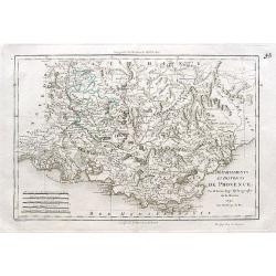
Départements et districts de Provence.
An excellent map of the Provence from Nimes until Monaco,
Date: Paris, ca. 1790
Selling price: ????
Please login to see price!
Sold in 2018
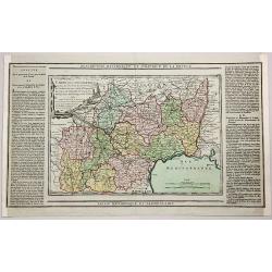
Description Historique et Politique de la France.
A map of the departments of Lot, Aveyron, Lozere, Ardeche, Gers, Garonne, Tarn, Herault, Gard, Htes Pyrenees, Ariège and Aude by Brion, the engineer geographer of the ki...
Date: Paris, 1790
Selling price: ????
Please login to see price!
Sold in 2018
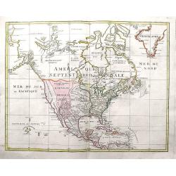
Amerique Septentrionale.
A large and scarce map of North America, including the recently discovered Sandwich Islands. With unusual areas, including a huge New Mexico and Louisian. Also a large pa...
Date: Augsburg, ca 1790
Selling price: ????
Please login to see price!
Sold in 2020
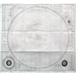
Das Planeten-System der Sonne wie es seit dem Jahr 1781 bekannt geworden.
An important and rare celestial chart of the solar system that includes Uranus, which was discovered by Sir Friedrich Wilhelm Herschel. Bode was the first to map its orbi...
Date: Berlin, ca 1790
Selling price: ????
Please login to see price!
Sold in 2018