Browse Listings
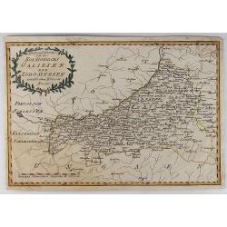
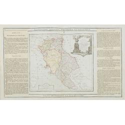
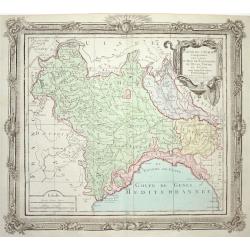
Spezial Karte von des Koenigreichs Galizien und Lodomerien Westlichen Kreisen.
Special Map of the Kingdoms of Galicia and Lodinerien on the border between Poland and Hungary. By Franz von Reilly in 1791. It features a decorative laurel title carto...
Date: Vienna, 1789
Selling price: ????
Please login to see price!
Sold in 2018
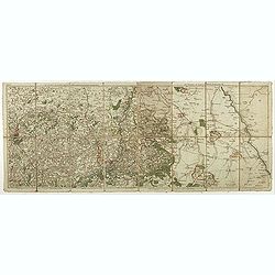
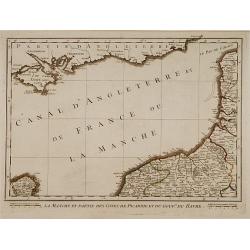
Les environs de Louvain..., Les environs de Limbourg, Rolduc,. . .
Showing the cities of Louvain, Liege, Aix la Chapelle, Cologne. . . The map was prepared by Jean Baptiste de Bouge (1757-1833), who prepared one of the first very detaile...
Date: Bruxelles, 1789
Selling price: ????
Please login to see price!
Sold in 2017
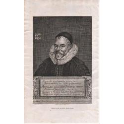
Portrait of: William Camden from Britannia.
Lettered in background "Giulielm Camden Clarenti / Praelecturae Historicae Fundator Munific / Pondere non numero". With six lines of Latin on plaque, beginning ...
Date: London, 1789
Selling price: ????
Please login to see price!
Sold in 2018
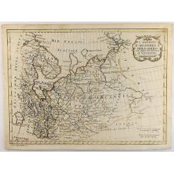
I Governi D'Arcangelo e Bielo-Ozero. . .
An unusual Vincenzo Pazzini Carli's copper engraved map of northern part of Russia in Europe, published in 1789. The map is filled with excellent topographic detail and ...
Date: Rome, 1789
Selling price: ????
Please login to see price!
Sold in 2021
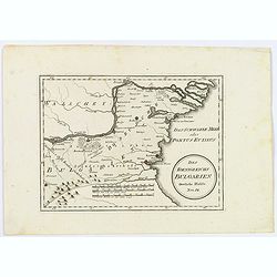
Des Koenigreichs Bulgarien. . .
Von Reilly's map of eastern Bulgaria as it was toward the end of the eighteenth century from the river Danube to the Black Sea. Shows rivers, mountains, larger cities and...
Date: Vienna, 1789
Selling price: ????
Please login to see price!
Sold in 2021
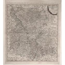
Des Russischen Reiches Statthalterschaften Pleskow, Polozk, Mohilew, Twer, Moskau, Koluga, Wolodimer, Iaroslaw, Tula, Smo, Lensko und Nischgorod. Nro.64
A map of the European part of Russia, that is centered on Moscow. Published by Franz Johann Joseph von Reilly, (1766-1820), who was a Viennese art dealer, who turned to m...
Date: Vienna, 1789
Selling price: ????
Please login to see price!
Sold in 2021
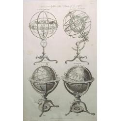
Spheres and Globes - System of Geography.
A detailed chart with four globes including Copernican, Armillary Sphere, Newly Improved Armillary Sphere, Terrestrial Globe and Celestial Globe. The print was published ...
Date: London, 1789
Selling price: ????
Please login to see price!
Sold in 2020
Der Chur Rheinische oder Neider Rheinische Kreis.
Fine detailed 1789 Homann Heir’s map of the lower Rhine circle with the electorates of Mainz, Trier and Cologne. Features a garland style title cartouche. Johann Bapt...
Date: Nuremberg, 1789
Selling price: ????
Please login to see price!
Sold in 2020
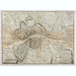
Grundriss der hochfürst. - erzbischöfliche Haupt und Residenz Stadt Salzburg im Jahr 1789 / geometrisch aufgenommen u. gezeichnet von A. F. H. v. Naumann
Uncommon plan of Salzburg as in the year 1789, drawn by A. F. H. Naumann. Engraved by Ch. T. C. Wirsnig.
Date: Salzburg, 1789
Selling price: ????
Please login to see price!
Sold in 2021
Charte vom Konigreich Norwegen . . .
Decorative map of Kingdom of Norway and the Faroe Islands (Faroese map inserted by C.G. Mengel). According to O.A.Wangensteens and some other charts of the Büschingian g...
Date: Nurenberg, 1789
Selling price: ????
Please login to see price!
Sold in 2022
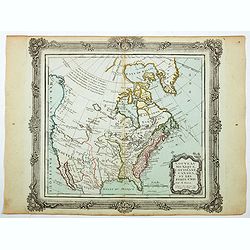
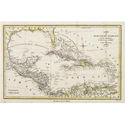
Nouveau Mexique, Louisiane, Canada..
A lovely 1786 map of North America by Desnos and Brion de la Tour. It shows North America according to the French with a northwest passage extending west from Labrador an...
Date: Paris, 1790
Selling price: ????
Please login to see price!
Sold in 2020
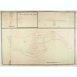
Plan de l'Isle de Goree.
A unusual map of the island of Goree. Includes an inset map of Senegalese coast, and a view of the port on the opposite upper corner. The title includes also a lettered k...
Date: ca. 1790
Selling price: ????
Please login to see price!
Sold in 2020
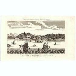
The City of Malacca in the East Indies.
A late eighteenth century copperplate view of the Malaysian city of Malacca - the oldest city on the straights of Malacca. The city entrance from the Malacca River is cle...
Date: London, 1790
Selling price: ????
Please login to see price!
Sold in 2020
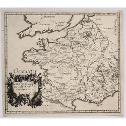
Galliae Descriptio ex Iulij Caesaris Commentarijs.
An antique map of ancient France or Gaul (Gallia). It is from about 1790 by an unknown mapmaker. There is an interesting cartouche featuring weapons and flags.
Date: Paris, 1790
Selling price: ????
Please login to see price!
Sold in 2021
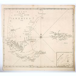
Kaart van het Zuidlyk Eind van Amerika. 1775.
An uncommon Dutch chart of the tip of South America, showing Patagonia, Tierra del Fuego and the Falkland Islands. With an inset of Staaten Land in the lower right corner...
Date: Amsterdam ca 1790
Selling price: ????
Please login to see price!
Sold in 2020
![[Lot of 11 maps of the Strait of Magellan] Carte du detroit de Magellan avec les Routes de la Bodeuse et de l'Etoile.](/uploads/cache/19991-(3)-250x250.jpg)
[Lot of 11 maps of the Strait of Magellan] Carte du detroit de Magellan avec les Routes de la Bodeuse et de l'Etoile.
Carte du Detroit de Magellan avec les Routes de la Bodeuse et de l'Etoile taken by the French discoverer Comte de Bougainvile, L.A. With in addition 10 maps / prints of...
Date: Paris, c. 1790
Selling price: ????
Please login to see price!
Sold in 2022
![[Lot of 2 prints] TABLEAU ANALYTIQUE des différentes positions de la Sphère, des diff'rents systèmes, des révolutions et des distances des Planètes, &c.](/uploads/cache/17613-(6)-250x250.jpg)
[Lot of 2 prints] TABLEAU ANALYTIQUE des différentes positions de la Sphère, des diff'rents systèmes, des révolutions et des distances des Planètes, &c.
Attractive set of two prints with a celestial and a terrestial globe, two spheres demonstrating the celestial systems of Ptolemy and Copernicus and several other diag...
Date: Pris, c. 1790
Selling price: ????
Please login to see price!
Sold in 2023
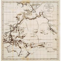
Globo Terrestre Delineato sulle ultime osservazioni con i viaggi e nuove scoperte del Cap. Cook, inglese
One of four sheets that make up Cassini's terrestrial globe of 1790 which measured 34cm in diameter and delineated the tracks of all three of Captain Cook’s voyages, a...
Date: Rome, 1790
Selling price: ????
Please login to see price!
Sold in 2023
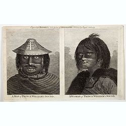
A Man of Prince William's Sound / A Woman of Prince William's Sound.
A pair of copperplate engravings of a man and a woman from Prince William's Sound in Gulf of Alaska - taken rom drawings by John Webber from John Hawkesworth's account of...
Date: London, ca 1790
Selling price: ????
Please login to see price!
Sold in 2023
-250x250.jpg)
A General Chart Exhibiting the Discoveries Made by Captn. James Cook in This and His Two Preceding Voyages; with the Tracks of the Ships Under His Command, by Lieutt. Robers of His Majesty's Royal Navy
This scarce, large map is based on Mercator's projection and was compiled by Lieut. Henry Roberts from Cook's surveys after the third expedition. The map, centered on Aus...
Date: London, ca. 1790
Selling price: ????
Please login to see price!
Sold in 2023
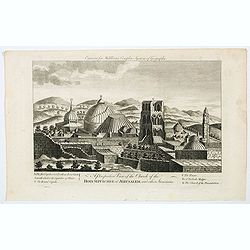
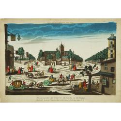
A Perspective View of the Church of the Holy Sepulchre at Jerusalem, and other Structures.
A nice copperplate engraving of the main churches to be found in Jerusalem toward the end of the eighteen century. Beneath the engraving is a lettered table of the tower...
Date: London, ca 1790
Selling price: ????
Please login to see price!
Sold in 2023
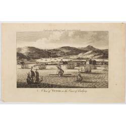
A View of Tunis on the Coast of Barbary.
An very attractive copperplate view of the north African city of Tunis in a region then known as the Barbary Coast, produced for Middleton's Complete System of Geography....
Date: London, ca 1790
Selling price: ????
Please login to see price!
Sold in 2023
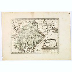
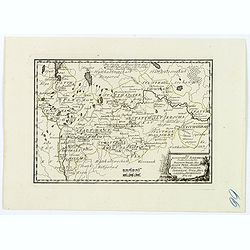
Die Landschaft Bessarabien.
A map of southwestern corner of Ukraine, bordering on the Black Sea, from Izmail on the Danube in the south, to Bender in Transnistria in the north. Larger towns and citi...
Date: Vienna, 1790
Selling price: ????
Please login to see price!
Sold in 2025
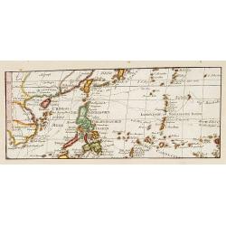
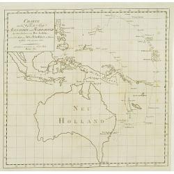
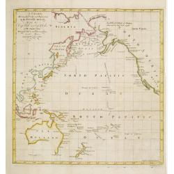
No title: Map of Philippines, Taiwan and China.
Interesting map centred on the Philippines. Showing the tracks of Byron, Wallis and Marshall.
Date: Vienna 1790
Selling price: ????
Please login to see price!
Sold in 2017
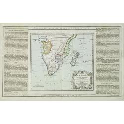
Partie de L'Afrique..
Map showing Southern part of Africa. Left and right box with geographical information for each part country on the continent.Prepared by Louis Brion de la Tour and publis...
Date: Paris 1790
Selling price: ????
Please login to see price!
Sold in 2009
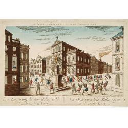
La destruction de la Statue royale a Nouvelle York.
One of the few European prints dealing with the Revolutionary war.J. Chereau was a publisher of optical print, established in Paris, rue St.Jacques. In the eighteenth and...
Date: Paris, 1790
Selling price: ????
Please login to see price!
Sold
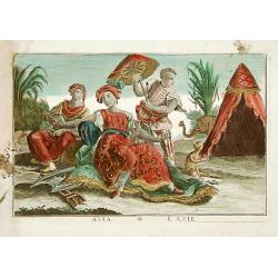
Asia / L'Asie: Asia personified as a woman.
A woman setting on a carpet and surrounded by two servants, an elephant and a monkey.
Date: France c. 1790
Selling price: ????
Please login to see price!
Sold in 2015
Pays Bas françois et Autrichien..
Map of Belgium. With on verso a chart showing the coasts of the French Channel.Louis Capitaine (1749-1797) worked with Belleyme and Chanlaire on Topographical maps of Fra...
Date: Paris ca.1790
Selling price: ????
Please login to see price!
Sold
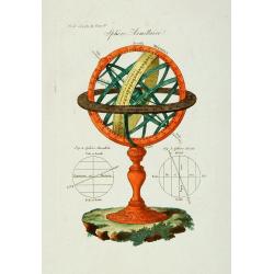
Sphére Armillaire.
Armillary sphere.
Date: Paris 1790
Selling price: ????
Please login to see price!
Sold in 2009
Carte welche die fahrt und Entdeckungen des Capitäns COOK, CLERKE, und GORE, in dem Jahren 1776_1780 vorstellt.
Showing the Pacific, with the tracks of Cook in 1777, Captain Clarck in 1779 and Captain Gore 1779.
Date: Germany c.1790
Selling price: ????
Please login to see price!
Sold
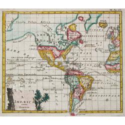
L' America.
A small map depicting the Americas, from the Italian edition of Claude Buffier's 'Geographie Universelle'.
Date: Venice, 1790
Selling price: ????
Please login to see price!
Sold
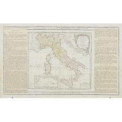
L' Italie Divisée en tous ses Etats..
Decorative map of Italy, showing Corsica and Sardinia. With ornamental title cartouche and inset map of the Mediterranean including Tunis, Malta and Pantelleria.Flanked b...
Date: Paris, 1790
Selling price: ????
Please login to see price!
Sold
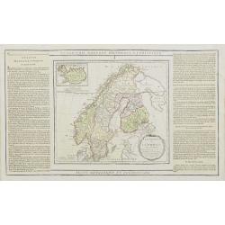
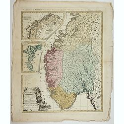
La Suede, et la Norwege Avec l'Islande..
Finely engraved map of Scandinavia, with inset map of Iceland in the upper left and decorative title cartouche.The map is flanked by two columns of French text containing...
Date: Paris, 1790
Selling price: ????
Please login to see price!
Sold in 2010

La Russie Européenne Conformément à l'Atlas de cet Empire. . .
Attractive map of the European part of Russia. Decorated with a title cartouche in the lower left corner.The map is flanked by two columns of French text containing geogr...
Date: Paris, 1790
Selling price: ????
Please login to see price!
Sold in 2009
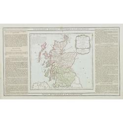
L'Ecosse..
Decorative map showing Scotland divided into northern and southern portions with all the county divisions noted. Embellished with fine title cartouche.The map is flanked ...
Date: Paris, 1790
Selling price: ????
Please login to see price!
Sold
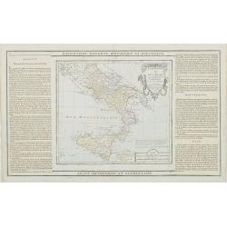
Etats du Roi des Deux Siciles avec les Métropoles Ecclésiastiques et tous leurs Suffragans..
Attractive map of southern Italy and Sicily with ornamental rococo-style title cartouche.The map is flanked by two columns of French text containing geographical informat...
Date: Paris, 1790
Selling price: ????
Please login to see price!
Sold in 2023
Etats de l' Eglise, de Toscane, Modène et Luques..
Decorative map of Italy covering the region centered on Florence and extending to show Modena, Bologna and Rome.With major cities of the area named among which Siena, Are...
Date: Paris, 1790
Selling price: ????
Please login to see price!
Sold
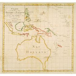
Fahrt des Lieut. William Bligh von Tofoa.. Timor..
Uncommon map showing the track of Wimmiam Bligh in 1789 on his ship Bounty Jakarta to Timor. With 3 inset maps: East coast of New Holland.Bligh's Islands and the Hebrides...
Date: Berlin 1790
Selling price: ????
Please login to see price!
Sold
Charte von dem weg den die Schiffe Alexander..
Fine and rare map of Australia and Indonesia and the Philippines. Showing the track, from Port Jackson in New South Wales to Batavia, of the vessels Alexander and Scarbor...
Date: Berlin 1790
Selling price: ????
Please login to see price!
Sold
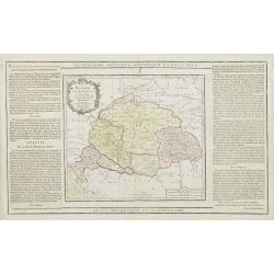
La Hongrie avec les Provinces adjacentes. . .
Attractive map of Hungary, adorned with a rococo-style title cartouche.Left and right box with geographical information about the area. Printed on 2 paste-on slips.Prepar...
Date: Paris, 1790
Selling price: ????
Please login to see price!
Sold in 2009
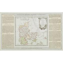
Le Danemark divisé par Provinces et Dioceses sous une Métropole..
Finely engraved map of Denmark, extending eastwards to show all islands including Bornholm. Decorative rococo-style cartouche.Left and right box with geographical informa...
Date: Paris, 1790
Selling price: ????
Please login to see price!
Sold
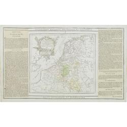
Les Pays Bas Francois Autrichiens, et Hollandois, Divisee en Provinces Civiles et Esslesiastiques..
A decorative copper engraved map of Benelux which extends to include portions of France and Germany. Decorative rococo-style cartouche.Left and right box with geographica...
Date: Paris, 1790
Selling price: ????
Please login to see price!
Sold in 2008
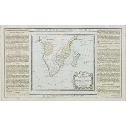
Partie de L'Afrique.. Le Congo, La Cafrerie &c.
Map showing the southern part of Africa with decorative rococo-style cartouche.Left and right box with geographical information for each part of the area. Printed on 2 pa...
Date: Paris, 1790
Selling price: ????
Please login to see price!
Sold in 2023
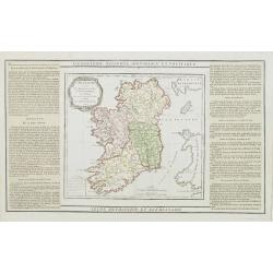
L'Irlande divisée..
Map showing Ireland, decorated with a rococo-style cartouche. Left and right a box with geographical information in French about the country (rivers, counties etc.). Prin...
Date: Paris, 1790
Selling price: ????
Please login to see price!
Sold
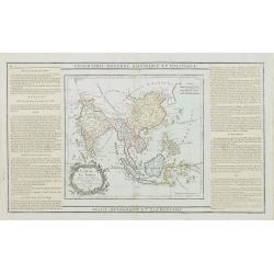
Chine, et Indes Avec les Isles avec les Isles, d'après les descriptions les plus exactes . . . 1790.
Attractive map of southern Asia, most of the East Indies, including China, Malaysia, Java, Borneo and the Philippines.Extending westwards to include India, the northern r...
Date: Paris, 1790
Selling price: ????
Please login to see price!
Sold in 2018
Charte von dem weg den die Schiffe Alexander..
Fine map of Australia and Indonesia and the Philippines. Showing the track, from Port Jackson in New South Wales to Batavia, of the vessels Alexander and Scarborough in t...
Date: Berlin 1790
Selling price: ????
Please login to see price!
Sold
Kaart van Nieuw Zuid Wales of de oostlijke kust van Nieuw Holland.
Dutch edition of this map by Cook, who was the first published full-scale map of the east coast of Australia as charted by Cook in the Endeavour in 1770. All names are tr...
Date: Haarlem c.1790
Selling price: ????
Please login to see price!
Sold
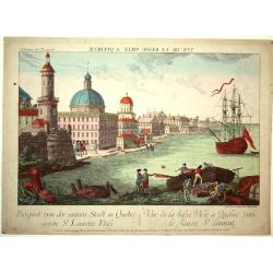
Vue de la Basse Ville a Quebec vers le Fleuve St. Laurent.
A lovely view of the river and city of Quebec with a ship and boat in the foreground. Engraved for a Vue d'Optique, it was designed to be viewed in a special apparatus th...
Date: Augsburg, ca.1790
Selling price: ????
Please login to see price!
Sold in 2008
Vue perspective des Environs de Leyden en Holande.
Attractive print of the Pieterskerk in the center of Leiden.J. Chereau was a publisher of optical prints, established in Paris, rue St.Jacques. In the eighteenth and nine...
Date: Paris 1790
Selling price: ????
Please login to see price!
Sold
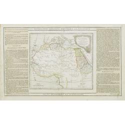
Partie de L'Afrique.. L'Egypte, La Barbarie, La Nigritie &c.
Map showing the northern half of Africa with decorative rococo-style cartouche.Flanked by two columns of French text containing geographical information about the area. M...
Date: Paris, 1790
Selling price: ????
Please login to see price!
Sold
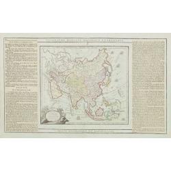
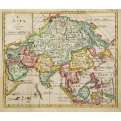
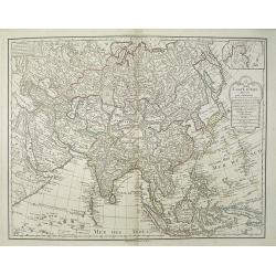
L' Asie Dressée pour l' étude de la Géographie..
Highly decorative map of Asia embellished with a landscape style title cartouche and several sailing ships.The map is of interest for the use of Mer de Corée, the sea be...
Date: Paris, 1790
Selling price: ????
Please login to see price!
Sold in 2010
![[No title] Kamtschatskisches Meer.](/uploads/cache/21312-250x250.jpg)
[No title] Kamtschatskisches Meer.
Engraved by S. V.Dorn. Early map of Alaska.
Date: Germany 1790
Selling price: ????
Please login to see price!
Sold
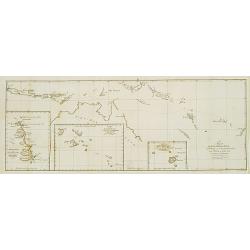
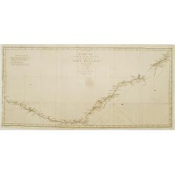
A chart Shewing the Tracks & Discoveries in The Pacific Ocean Made By Capt. Cook and Capt. Clerke..
Map of Pacific Ocean showing tracks of Resolution and Discovery in the years 1777-1780 made by Capt. Cook and Capt. Clerke. Engraved by Matthew Smith.
Date: London 1790
Selling price: ????
Please login to see price!
Sold
La Turchia d. Europa.
A small map depicting Greece and the Balkan, from the Italian edition of Claude Buffier's ' Geographie Universelle'.
Date: Venice, 1790
Selling price: ????
Please login to see price!
Sold
Les Isles de Sardaigne et de Corse..
Attractive copper engraved map of Corsica and Sardinia with Rome at extreme left. Good detail throughout including villages, rivers, and coastlines. Decorated with a nice...
Date: Paris 1790
Selling price: ????
Please login to see price!
Sold
Etats de l' Eglise, de Toscane, Modene et Luques..
Decorative map covering the region centered on Florence and extending to show Rome and Modena. Decorative cartouche and rococo style border.
Date: Paris 1790
Selling price: ????
Please login to see price!
Sold
Estats du Roi des Duex Siciles..
Attractive map of southern Italy and Sicily. Decorative rococo-style cartouche and surrounding border that was printed from a separate copper plate.
Date: Paris 1790
Selling price: ????
Please login to see price!
Sold
Partie de l' Italie Comprenant les Etats du Roy de Sardaigne
Attractive map of northwest Italy and the Golfo di Genova. Adorned with a very nice title cartouche and enclosed in a rococo-style border.
Date: Paris 1790
Selling price: ????
Please login to see price!
Sold
L' Etat de Venise et le Duche de Mantoue
Nice map covering the region centered on Venice and extending to include Modena and Bologne, and eastward to Trieste and Istria. Decorated with a fine title cartouche and...
Date: Paris 1790
Selling price: ????
Please login to see price!
Sold
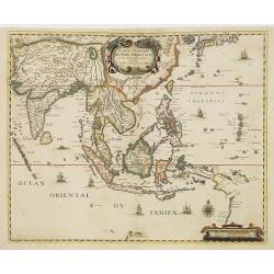
Carte Generale des Indes Orientales..
Uncommon map of South East Asia based on Jansson's map of 1641, with good detail on Philippines. Showing Taiwan and the Southern part of Japan. Many Dutch names especiall...
Date: Paris, 1790
Selling price: ????
Please login to see price!
Sold in 2011
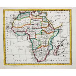
Africa.
An uncommon map of the African continent, engraved by Marco di Pietro, probably for Luigi Rossi's 'Nuovo Atlante Universe'.
Date: Milan, c. 1790
Selling price: ????
Please login to see price!
Sold
Karte des Mexicanischen Meerbusens und der anstofsenden Inseln und Laender..
Fine map of the Crribbean. Included in the uncommon German text edition of Campens travels.Engraved by Knittel.
Date: Reutlingen, c.1790
Selling price: ????
Please login to see price!
Sold
Vue de la Haute ville a Quebec..
A beautiful view of square at the road to the Millbarracks in Quebec with soldiers in the foreground. Engraved for a Vue d'Optique, it was designed to be viewed in a spec...
Date: Augsburg 1790
Selling price: ????
Please login to see price!
Sold in 2008
L' Asia.
A small map depicting the Asia continent, from the Italian edition of Claude Buffier's ' Geographie Universelle'.
Date: Venice, 1790
Selling price: ????
Please login to see price!
Sold in 2009
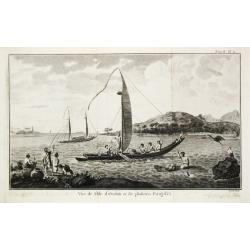
Vue de l' Isle d' Otahiti et de plusieurs Pirogues.
Captain James Cook (1728-79), explorer, circumnavigator and hydrographer. Three voyages, 1768-71, 1772-75 and 1776-79. From 1778 on printed editions of' Captain Cook's Tr...
Date: Paris, c. 1790
Selling price: ????
Please login to see price!
Sold
Etats de Pologne et de Lithuanie..
Handsome map of Poland and Lithuania with decorative title cartouche.The map is flanked by two columns of French text containing geographical information about the area. ...
Date: Paris, 1790
Selling price: ????
Please login to see price!
Sold
L' Afrique Dressée pour l' étude de la Géographie..
Highly decorative map of Africa embellished with a landscape style title cartouche and several sailing ships.The interior of the continent contains little geographical in...
Date: Paris, 1790
Selling price: ????
Please login to see price!
Sold
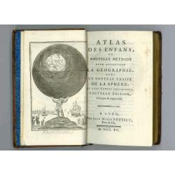
ou nouvelle méthode pour apprendre la géographie,..
Atlas for the children with 24 maps of the World and continents and maps of European countries. Size of the maps: 13x17cm size of the binding: 17x11x3cm.With fine engrave...
Date: Lyon, Bruyset Père & Fils, 1790
Selling price: ????
Please login to see price!
Sold in 2008

Koran Page
Single leaf from a Koran manuscript on paper in gold leaf, tempera and ink. Black text in Arabic with interlinear red text in Persian. The script is Nasta?liq. Beautiful ...
Date: India, circa 1790
Selling price: ????
Please login to see price!
Sold in 2008

Uomo del Brasile. / Homme du Brasil.
Full portrait of a Brazilian hunter. From "Raccolta di ? stampe." a series of historically significant eighteenth-century copper plate engravings by Venetian en...
Date: Venice, Antonio Zatta, c.1790
Selling price: ????
Please login to see price!
Sold in 2013
Le Mole St Nicolas dans l'Isle de St Domingue, Vu du Mouillage
Drawn by Nicolas Ozanne and engraved by Jeanne F. Ozanne.
Date: Paris, c.1790
Selling price: ????
Please login to see price!
Sold in 2008

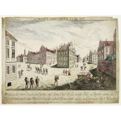
Vue de La Place et de la Fontaine de Top-Hané.
So-called optical print of Tophane and Kılıç Ali Paşa Mosque. In the eighteenth and nineteenth centuries there were many popular speciality es...
Date: Paris, 1790
Selling price: ????
Please login to see price!
Sold
Carte de Asie dresse´e pour l'instruction / par Guil. Delisle et Phil. Buache ? nouvellement revue et augmentee´ par Dezauche.
Map of Asia. Relief shown pictorially. Small inset map on the upper right corner. Published by Dezauche.Notable for depiction of Hokkaido, here called "I.Chicha ou J...
Date: Paris, ca. 1790
Selling price: ????
Please login to see price!
Sold in 2009
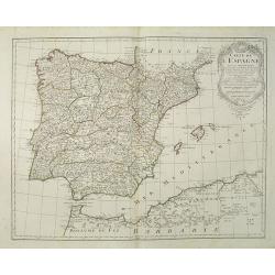
Carte de l'Espagne Dressée par Guillaume Delisle sur la description de Rodrigo Mendez Sylva . . . Le tout augmenté et vérifié en 1765 Par Phil. Buache, de l'Académie des Sciences.
Map of Spain and Portugal, including the North African coast and good detail for Majorca, Minorca and Ibiza. Taken from the Atlas Géographique.. published by Dezauche, a...
Date: Paris, c.1790
Selling price: ????
Please login to see price!
Sold in 2022
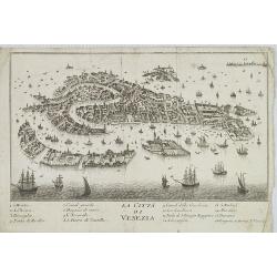
La Citta di Venezia.
Uncommon and decorative plan of Venice.
Date: Italy, ca. 1790
Selling price: ????
Please login to see price!
Sold in 2009
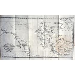
A Chart of the Interior part of North America demonstrating the very great possibility of an Island of Navigation from Hudson's Bay to the West Coast
Rare and curious map of a supposed "Northwest Passage" from the Hudson Bay into the Pacific Ocean. Based upon the explorations of John Meares in 1788 and 1789....
Date: London, 1790
Selling price: ????
Please login to see price!
Sold in 2009
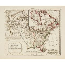
Canada, Louisiane, États-Unis.
Uncommon third state with changed title cartouche and corrigés par le Cen.Lamarche son successeur added to title.Two maps on one sheet. The map of the western part of No...
Date: Paris, 1790
Selling price: ????
Please login to see price!
Sold in 2010
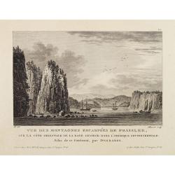
Vue Des Montagnes Escarpées De Fraisler, Sur La Côte Orientale De La Baye George Dans L'Amérique Septentrionale. Atlas de ce Continent, par Desbares.
Fine view of St. Georges Bay, Nova Scotia, east coast of Canada. '12.' inscribed upper right. Engraved by Pillement. "A Paris, chez Noel, Md. D'Estampes, Rue St. Jac...
Date: Paris, ca. 1790
Selling price: ????
Please login to see price!
Sold in 2021
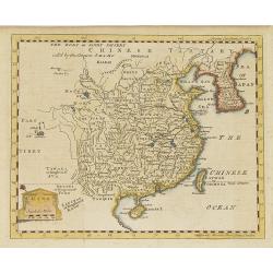
China.
Map of China, including Taiwan and Korea.
Date: London, c. 1790
Selling price: ????
Please login to see price!
Sold in 2010
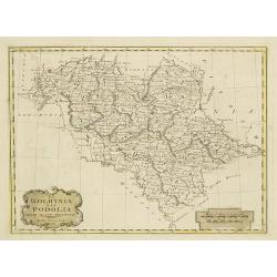
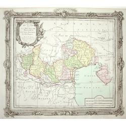
La Wolhynia e la Podolia divise ne' loro Palatinati.
From "Atlante geografico" by Bartolomeo Borghi (1750-1821), published in Sienna 1788-1800.
Date: Siena, Presso Pazzini Carli, 1790
Selling price: ????
Please login to see price!
Sold in 2010