Browse Listings
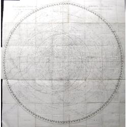
Stereographischer Entwurf des Gestirnten Himmels vom Nordpol bis zum 38sten Grad südlicher Abweichung.
A very large graphic celestial chart depicting the North equatorial pole. Filled with stars and constellations. Bode produced several highly important celestial works. En...
Date: Berlin, ca 1790
Selling price: ????
Please login to see price!
Sold in 2018
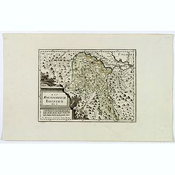
Das Koenigreich Bosnien.
A nice map of Bosnia, mapped with its old borders, prior to the Ottoman rule. Western Bosnia is labelled "Turkish Croatia". The region is seen as very heavily w...
Date: Vienna, 1790
Selling price: ????
Please login to see price!
Sold in 2018
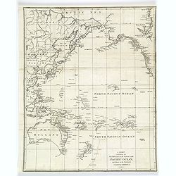
A Chart exhibiting the New Discoveries in the North & South Pacific Ocean, also those on the Northwest Coast of America.
A copper engraved map that was made only a few years after Cook's voyage to Australia. The map shows Port Jackson and other settlements in New South Wales. Other discover...
Date: London, ca 1790
Selling price: ????
Please login to see price!
Sold in 2018
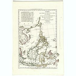
Carte des Indes en Deca et au Dela du Gange, avec les Isles de la Sonde, Borneo, les Moluqes et les Philippines partie Orientale. Par M. Bonne, ingenieur Hydrographe de la Marine. A' Venise, Par P. Santini 1790.
A copper engraved map, prepared by R. Bonne and L'Abbe Grenet from "Atlas portatif a l'usage des colleges, pour servir a l'intelligence des auteurs classiques. Par M...
Date: Venice, 1790
Selling price: ????
Please login to see price!
Sold in 2018
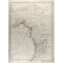
Untitled Map of West Africa (Cyrillic)
A rare cyrillic edition of the Bonne & Lattré copper engraved map of West Africa. It covers from the Gold Coast (modern day Ghana), south around the Bight of Benin t...
Date: St Petersburg, 1790
Selling price: ????
Please login to see price!
Sold in 2019
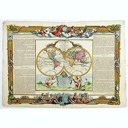
Mappe-monde dréssée pour l'étude de la géographie, relativement aux auteurs les plus modernes . . .
World map in double hemisphere. North America with a large Mer de L'Quest or Sea of the West. A great sea, easily the size of the Mediterranean, to flow from the then-kno...
Date: Paris, 1790
Selling price: ????
Please login to see price!
Sold in 2018
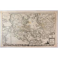
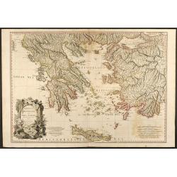
A Correct Map of Ancient Greece.
A striking, highly detailed copper engraved map of Greece in ancient times. The map provides good topographic details. An inset map of north-eastern Sicily, Italy, adorns...
Date: London, 1790
Selling price: ????
Please login to see price!
Sold in 2019
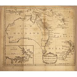
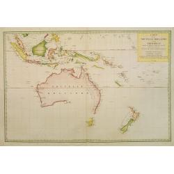
New Holland & the Adjacent Islands , Agreeable to the Latest Discoveries.
A very fine, rare, important map with an inset map of 'A Sketch of Port Jackson'. A very detailed period map of what is now called Australia, with the southern portion co...
Date: Edinburgh,1790
Selling price: ????
Please login to see price!
Sold in 2019
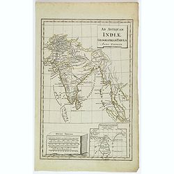
Ad Antiquam Indiae Geographiam Tabula.
A map of the ancient map of the Indian subcontinent, with an inset of Taprobana (Ceylon / Sri Lanka), next to a set of mileage scales, in the shape of a slab of rock. Pla...
Date: Anon, ca 1790
Selling price: ????
Please login to see price!
Sold in 2020
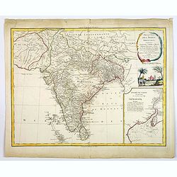
Presqu 'Isle Des Indes Orientales. . .
A nice large and detailed map of India by de Vaugondy with inset map of the entree of the river Ganges.
Date: Paris, 1790
Selling price: ????
Please login to see price!
Sold in 2018
Map of the Steppe between the Lower Volga and the Don, where the Caspian Sea was formerly united with that of Azof.
A Russian map showing the rivers Don and lower Volga flowing into the Caspian Sea. Many other small rivers and tributaries are engraved, along with places and salt lakes ...
Date: London, ca 1790
Selling price: ????
Please login to see price!
Sold in 2020
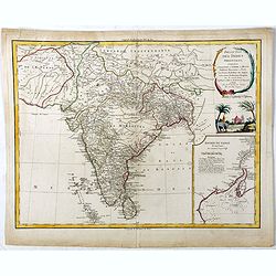
Presqu 'Isle Des Indes Orientales. . .
A nice large and detailed map of India by de Vaugondy with inset map of the entree of the river Ganges. With a decorative scene with an elephant underneath the title cart...
Date: Paris, 1790
Selling price: ????
Please login to see price!
Sold in 2019
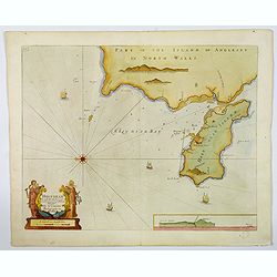
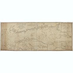
Holy-Head.
An impressive sea chart of Holy-Head in North Wales, from Greenville Collins, Hydrographer to the King (George III), taken from his Great Britain Coasting Pilot atlas. Th...
Date: London, ca 1790
Selling price: ????
Please login to see price!
Sold in 2020
Die Otschakowische Tartarey oder Westliches Nogaj, auch Jedisan. Nro 12.
A map of the Ukraine, between the Bug River and the Dniestr River, and Yeni Duni (todays Odessa) on the Black Sea, Ochakiv also known as Ochakov, Palance and Bender in Mo...
Date: Vienna, 1790
Selling price: ????
Please login to see price!
Sold in 2019
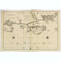
Carte Particuliere des Costes Meridionales d'Angleterre Qui Comprend l'Isle de Wight, et le Havre de Portsmouth. . .
A superb, large sea chart of the Isle of Wight and the Dorsetshire and southern Hampshire coasts between Wareham in Dorset and Bosham in Hampshire.The marine chart includ...
Date: Paris, ca 1790
Selling price: ????
Please login to see price!
Sold in 2019
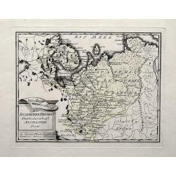
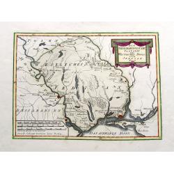
Des Russischen Reiches Statthalterschaft Archangel Nro. 66.
A map of a part of Russia with Arkhangelsk, the Kola peninsula, and the White Sea. Extends south until Wologda and todays Jaroslawl. With rivers, mountains, lakes, etc.
Date: Vienna, 1790
Selling price: ????
Please login to see price!
Sold in 2019
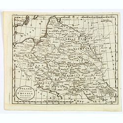
Poland, Lithuania and Prussia from the latest Authorities.
A map of part of Eastern Europe by William Guthrie, published in London in the late eighteenth century. Map shows major towns and cities, rivers, forests, mountains and n...
Date: London, 1790
Selling price: ????
Please login to see price!
Sold in 2020
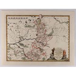
Die Landschaft Bessarabien.
A map of southwestern corner of Ukraine, bordering on the Black Sea, from Izmail on the Danube in the south, to Bender in Transnistria in the north. Larger towns and citi...
Date: Vienna, 1790
Selling price: ????
Please login to see price!
Sold in 2021
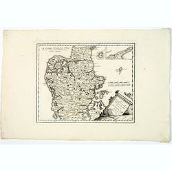
Des Konigreichs Daenemark halbinsel Jutland.
A map of the Danish province of Jutland, from J. Von Reilly's scarce Grosser Deutscher Atlas. Both Von Reilly & Schraembl led a marked revival of map making in Vienna...
Date: Vienna, 1790
Selling price: ????
Please login to see price!
Sold in 2020
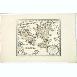
Des Konigreichs Daenemark Inseln Seeland, Moen, Bornholm, Funen, Langeland, Laaland, Falster.
A nice map by Von Reilly of several of Denmark's numerous islands. This map shows the islands of: Funen, Zealand, Falster, Langeland, Mon, Lolland, and has an inset of Bo...
Date: Vienna, 1790
Selling price: ????
Please login to see price!
Sold in 2020
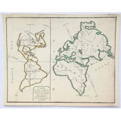
Carte des Deux Continents.
An unusual little map showing the comparison between the length of the vertical lines which show the greatest linear extent for each continent (Eurasia is by this measure...
Date: Paris, ca 1790
Selling price: ????
Please login to see price!
Sold in 2019
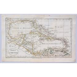
Indes Occidentales.
An antique map of the West Indies centered around Cuba with the Caribbean islands, Mexico and parts of North and South America.Jacques Blondeau (1766-1841) was a French c...
Date: Paris, ca 1790
Selling price: ????
Please login to see price!
Sold in 2023
Die Landschaft Bukowina Nro. 8.
A fine map of the Bukovina (Bukowina, Bucovina), a region in todays Romania and Ukraine that until WWI was the easternmost province of the Austrian Empire. Shows Chotyn (...
Date: Vienna, 1790
Selling price: ????
Please login to see price!
Sold in 2019
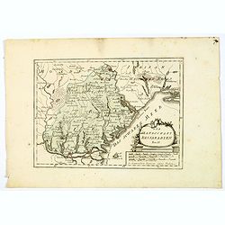
Des Russischen Reiches statthalterschaften Woronesch, Belgorod, Kiow o. Kleinrussland und Charkow od. d. Prussische Ukraine. Nro. 63.
A map of a part of the Ukraine and Russia, with Kiev, Luhansk, Charkow, Belgorod, and Voronezh. Richly detailed with many smaller towns in between. Also the Dniepr, Donez...
Date: Vienna, 1790
Selling price: ????
Please login to see price!
Sold in 2019
![[Map of Asia in Cyrillic]. Аз1я Раздѣле нная на](/uploads/cache/44338-250x250.jpg)
[Map of Asia in Cyrillic]. Аз1я Раздѣле нная на
A map of Asia. Аз1я Раздѣле нная наThe map is interesting for use of "Sea of Korea" for the sea between Korea and Japan.This Cyrillic version of...
Date: Paris / St.Petersburg, ca. 1790
Selling price: ????
Please login to see price!
Sold in 2023
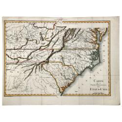
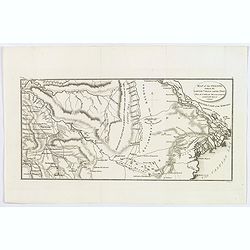
CARTE de la Partie Meridionale des ETATS-UNIS.
A nice example of this scarce and highly detailed map of the southern United States, showing excellent topography, roadways, and a great many place names and Indian tribe...
Date: Paris, 1790
Selling price: ????
Please login to see price!
Sold in 2019
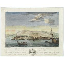
Le port de Bastia vu du coté de l'est. . .
Beautiful engraved profile view of Bastia, after Nicolas Ozanne engraved by Le Gouaz.
Date: Paris, ca. 1790
Selling price: ????
Please login to see price!
Sold in 2023
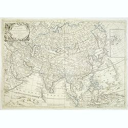
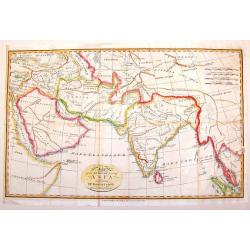
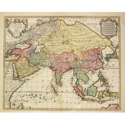
Carte d'Asie divisé en ses différénts Empires et Royaumes avec les nouvelles découvertes faîtes au Nord par différents voyageurs
Uncommon French map of Asia with fine title cartouche upper left. Inset map of Bering Strait.The map is of interest for the use of East Sea, the sea between Korea and Jap...
Date: Paris, 1791
Selling price: ????
Please login to see price!
Sold in 2012
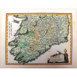
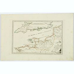
Des Konigreichs Ireland Provint Mounster
This detailed map of southern Ireland depicts the detail of the provinces of Leinster & Connaught. The copper engraved map illustrates the "Map of Munster" ...
Date: Vienna, 1791
Selling price: ????
Please login to see price!
Sold in 2013
Map of the South East Part of Asia.
This important map of Southeast Asia was produced for Dr. Robertson's Historical Disquisition, published in England by Cadell in 1791. It depicts the knowledge that Ancie...
Date: London, 1791
Selling price: ????
Please login to see price!
Sold in 2014
Die Markgraftschaft in ihre Kreise Eingetheilt Nro. 103.
Nice detailed copper engraved map of the Margraviate of Lustia divided into parts. Embellished with a unique diamond-shaped, ribboned cartouche.Joseph von Reilly (1766–...
Date: Vienna, 1791
Selling price: ????
Please login to see price!
Sold in 2016
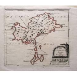
Die Inseln Iviza und Formentera.
Very rare map showing Ibiza and Formentera. With interesting notes in German: Formentera being uninhabited; scattered houses on Ibiza; passage for large ships;...
Date: Vienna, 1791
Selling price: ????
Please login to see price!
Sold in 2015
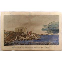
Platon Sur le Cap Sunium au Milieu de ses Disciples.
View of the Temple of Poseidon with Plato and Disciples by Bocage. Prepared in 1791 to illustrate the travels of Anacharis.
Date: Paris, 1791
Selling price: ????
Please login to see price!
Sold in 2019
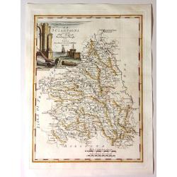
La Scampagna.
Fine map of “La Sciampagna" (Champagne) by Bartolammeo Borghi. Edited by Vincenzo Pazzini Carli and is from the atlas "Atlante Novissimo".Striking cartou...
Date: Sienna, 1791
Selling price: ????
Please login to see price!
Sold in 2021
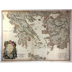
Greece, Archipelago and Part of Anadoli by L.S. De La Rochette
A large folio engraved map of Greece and part of Turkey. Engraved by William Palmer. Showing the Peloponnese, Central Greece, southern part of Albania, Constantinople in ...
Date: London, 1791
Selling price: ????
Please login to see price!
Sold in 2016
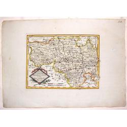
Der Koniglichen Republik Polen Woiwodschaft Podlachien...
Pleasing map of the Royal Republic of Poland by Franz von Reilly in 1791. It features a decorative title cartouche with busts and a wolf. Franz von Reilly (1766 - 1820) ...
Date: Vienna, 1791
Selling price: ????
Please login to see price!
Sold in 2018
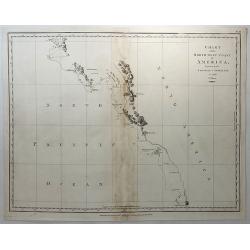
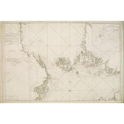
Chart of the North West Coast of America Explored by the Bousole & Astrolabe in 1786. (2nd Sheet)
A fine copperplate chart of the northwest coast of America from Mount La Touche to Cape Redondo. From La Perouse’s ATLAS DU VOYAGE DE LA PEROUSE. Published by G.G &...
Date: London, 1791
Selling price: ????
Please login to see price!
Sold in 2018
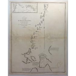
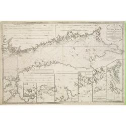
Plan of the Kurile Islands and Lands Little Known. . .
A fine copperplate chart of the Kirile Islands. From La Perouse’s ATLAS DU VOYAGE DE LA PEROUSE. Published by G.G & J. Robinson in London in 1798. Engraved by Neale...
Date: London, 1791
Selling price: ????
Please login to see price!
Sold in 2018
Certificaet N° 200.
1000 guilder Dutch Certificate number 200 of 200 issued. 1791. This certificate represented a 1/200 interest in $ 130,000 face amount of the United States "Liquidate...
Date: Antwerp, 30 march 1791
Selling price: ????
Please login to see price!
Sold in 2018

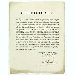
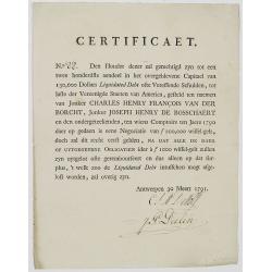
Certificaet N° 148.
1000 guilder Dutch Certificate number 148 of 200 issued. 1791. This certificate represented a 1/200 interest in $ 130,000 face amount of United States "Liquidated De...
Date: Antwerp, 30 March 1791
Selling price: ????
Please login to see price!
Sold in 2019
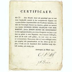
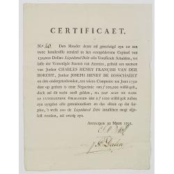
Certificaet N° 62.
1000 guilder Dutch Certificate number 62 of 200 issued. 1791. This certificate represented a 1/200 interest in $ 130,000 face amount of United States "Liquidated Deb...
Date: Antwerp, 30 March 1791
Selling price: ????
Please login to see price!
Sold in 2019
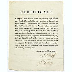
Certificaet N° 160.
1000 guilder Dutch Certificate number 160 of 200 issued. 1791. This certificate represented a 1/200 interest in $ 130,000 face amount of United States "Liquidated De...
Date: Antwerp, 30 March 1791
Selling price: ????
Please login to see price!
Sold in 2019
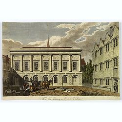
The New Library at Oriel College.
A nice copperplate engraved view of the New Library at Oriel College, Oxford, showing labourers unloading a heavy block of stone from a cart. From 'The Oxford Almanack'. ...
Date: Oxford, ca 1791
Selling price: ????
Please login to see price!
Sold in 2020
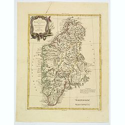
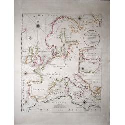
La Norvegia divisa Nelle Sue, Provincie Di nuova Projezione.
A fine large map of Norway, engraved by Zuliani after Pitteri. Few maps of Norway on its own were published during this period. Map shows the country divided into its pro...
Date: Venice, 1791
Selling price: ????
Please login to see price!
Sold in 2019
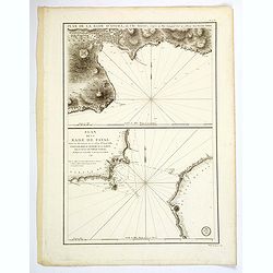
Plan de la Rade d'Angra, en L'Ile Tercere. . . / Plan de la Rade de Fayal. . .
A twin chart of the two harbours of Angra and Fayal (Faial) in the Azores, surveyed by the Depot General de la Marine in Paris towards the end of the eighteenth century. ...
Date: Paris, ca 1791
Selling price: ????
Please login to see price!
Sold in 2019
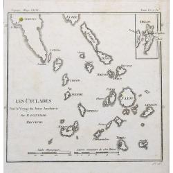
Les Cyclades. . .
A map of Greek islands called the Cyclades in the Aegean Sea. The map extends from Athens to Anafe. Including Andros, Mikonos, Naxos, Ios, Milos, Santorini. An inset map ...
Date: Paris, 1791
Selling price: ????
Please login to see price!
Sold in 2019
Die Englischekuste dem Nordlichen Frankreich.
Von Reilly's map of the English Channel, the Channel Islands, southern England and northern France. From the Atlas Schauplatz der funf Theile der Welt. With some coastal ...
Date: Vienna, 1791
Selling price: ????
Please login to see price!
Sold in 2021
Uebersicht der Europaeischen Seeküsten verfasst von Herrn Caington Bowles. . .
A very decorative, very large map showing all European coasts: includes North sea, East sea, Atlantic ocean and the Mediterranean sea. On inset you see the eastern Medite...
Date: Vienna, 1791
Selling price: ????
Please login to see price!
Sold in 2020
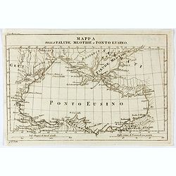
Mappa della Palude Meotide e Ponto Eusino.
An uncommon map of the Black and Azof Seas in the Crimea. Probably from Barthelemy Jean Jacques, Viaggio d'Anacarsi il giovine nella Grecia, 1791, Antonio Zatta e figli, ...
Date: Venice, 1791
Selling price: ????
Please login to see price!
Sold
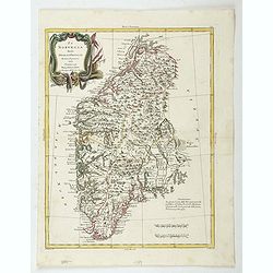
La Norvegia divisa Nelle Sue, Provincie Di nuova Projezione.
A fine large map of Norway, engraved by Zuliani after Pitteri. Few maps of Norway on its own were published during this period. Map shows the country divided into its pro...
Date: Venice, 1791
Selling price: ????
Please login to see price!
Sold in 2022
New and correct chart of the Gulf of Finland from the Russian and Swedish surveys Regulated and Ascertained by celestial observations. . .
Large scale blue-backed chart with three insets, . The Bay of Revel. The entrance of Cronstadt. The entrances to Fredrichstamn with Afpo Isles. The main chart has Saint P...
Date: London, Liverpool, 1791
Selling price: ????
Please login to see price!
Sold in 2023
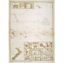
Carte d'une Partie de la Mer du Sud..
Covering the area from lower left New Zealand, up to Hawaii in the top. With 46 insets of islands in the South Pacific.
Date: Paris 1791
Selling price: ????
Please login to see price!
Sold
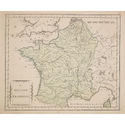
Das Heutige Frankreich.
Franz Johann Joseph von Reilly. He was active as an art dealer, publisher and mapmaker in Vienna. Issued in "Schauplatz der Welt".
Date: Veinna 1791
Selling price: ????
Please login to see price!
Sold
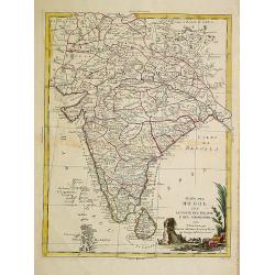
Stato del Mogol con le Coste del Malabar..
Fine map of India including Ceylon.
Date: Venice 1791
Selling price: ????
Please login to see price!
Sold
![[Title page] Grosser Deutscher Atlas.](/uploads/cache/11950-250x250.jpg)
[Title page] Grosser Deutscher Atlas.
Very decorative title page from the Grosser Deutscher Atlas published by Franz Joh. Jos. Von Reilly. The engraver was Karl Schütz, after a design by Vinzenz Georg Kining...
Date: Vienna 1791
Selling price: ????
Please login to see price!
Sold
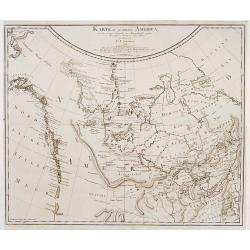
Karte des nördlichsten America..
Rare 18th Century map covering the NW Coast of America South to Cape Mendocino, the Missouri River and the Ohio River and extending North to the include the Bering Strait...
Date: Berlin 1791
Selling price: ????
Please login to see price!
Sold
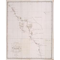
Entwurf der neuesten.. Nordwestküste von America.
Shows the most recent discoveries at the Northwest Coast of America according to Hanna, Johnstone, Wedgborough, Portlock, Dixon, Duncan, Meares and de la Quandra. Include...
Date: Falk 1791
Selling price: ????
Please login to see price!
Sold
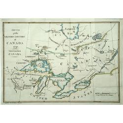
Sketch of the Western countries of Canada 1791./ Westliches Canada.
Rare map of the Great Lakes region up to James Bay. After a design by C.Reichard and engraved by Brauns. Published in See und Land-Reisen, by B.Gottlob Hoffmann.
Date: Hamburg 1791
Selling price: ????
Please login to see price!
Sold
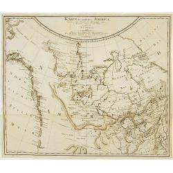
Karte des nördlichsten America..
Rare 18th Century map covering the NW Coast of America South to Cape Mendocino, the Missouri River and the Ohio River and extending North to the include the Bering Strait...
Date: Berlin 1791
Selling price: ????
Please login to see price!
Sold

Petrus Plancius.
A portrait of the famous Dutch cartographer.
Date: Amsterdam, 1791
Selling price: ????
Please login to see price!
Sold
Pass Charta öfver N:ra Delen af Östersjön, Ålands Haf med S:dra Del:en af Botten-Hafvet..
Map of the opposing coasts of Sweden and Finland, centred on the Finnish region of Aland.With inset plans of the Northeasternest islands belonging to Aland in upper right...
Date: Stockholm 1791
Selling price: ????
Please login to see price!
Sold
Pass Charta öfver Finska Wiken..
Maritime chart centred on the Gulf of Finland, depicting the opposing coasts of Finland and Russia.With 6 inset plans in the lower part of the map, illustrating enlargeme...
Date: Stockholm 1791
Selling price: ????
Please login to see price!
Sold
Carte de la Nouvelle Hollande et des Archipels..
Large map centered on Australia, whose southeastern seacoast is not delineated. It includes Indonesia and New Zealand. Just part of Tasmania is outlined.The title informs...
Date: Paris, 1791
Selling price: ????
Please login to see price!
Sold in 2008
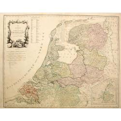
Karte von der Republik der Verenigten Niederlande..
Map of the present-day Netherlands with inset of Limburg. Von Reilly published a large series of maps over a long period of time.
Date: Vienna, 1791
Selling price: ????
Please login to see price!
Sold in 2023
Certificaet N° 40.
1000 guilder Dutch Certificate number 40 of 200 issued. 1791. This certificate represented a 1/200 interest in $ 130,000 face amount of the United States "Liquidated...
Date: Antwerp, 30 march 1791
Selling price: ????
Please login to see price!
Sold in 2008
Certificaet N° 88.
1000 guilder Dutch Certificate number 40 of 200 issued. 1791. This certificate represented a 1/200 interest in $ 130,000 face amount of the United States "Liquidated...
Date: Antwerp, 30 march 1791
Selling price: ????
Please login to see price!
Sold in 2008
Greece. Archipelago and Part of Anadoli. By L.S. de la Rochette. MDCCXC. London, Published for Willm. Faden, Geographer to the King. January 1st. 1791
Large Folio engraved map of Greece and Western part of Turkey from W. Faden, engraved by William Palmer. Showing the Peloponnese, Central Greece, southern part of Albania...
Date: London, 1791
Selling price: ????
Please login to see price!
Sold in 2009
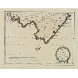
Der Insel Majorca Südlicher Theil. . .
Map showing the southern part of Majorca and just off the south coast of Mallorca, the island of Cabrera. Including cities of Palma, Santueri, Estarella. Published by Fra...
Date: Vienna, 1791
Selling price: ????
Please login to see price!
Sold in 2010
![[Title page] Atlas Nationale Portatif de la France. . .](/uploads/cache/31044-250x250.jpg)
[Title page] Atlas Nationale Portatif de la France. . .
Charming title page of an uncommon atlas of France. The text is set in a white area in the shape of France and Corsica, surrounded by leaves and flowers and a large angel...
Date: Paris, 1791
Selling price: ????
Please login to see price!
Sold in 2016
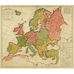
A map of Europe divided into its Empires Kingdoms &c.
Detailed map of Europe showing northern part of Africa. Prepared by L.Delarochette after Jean Pallairet (1697-1774). A geographer born in Montauban, France, who died in W...
Date: London c.1792
Selling price: ????
Please login to see price!
Sold
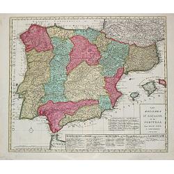
Les Royaumes d?Espagne et de Portugal.
Jan Berend Elwe. Amsterdam-based publisher. Published a pocket-atlas of the Netherlands (1786) and of Germany (1791). Published in 1792 a folio-atlas with 37 maps.A map o...
Date: Amsterdam, 1792
Selling price: ????
Please login to see price!
Sold in 2008

Aussicht der Kirchie St. Sophie zu Constantinopel / Die Solimannie zu Constantinopel, gestifftet von den dem Sultan Solimann.
From 'Algemeine Welthistorie (der Neuern Zeiten)', edited by S.J.Baumgarten, J.S.Semler a.o.The Sofia and the Soliman Moskee in Istanbul.
Date: Halle, 1763-1792
Selling price: ????
Please login to see price!
Sold
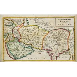
Geographische Karte von Persien. Arabia
From 'Algemeine Welthistorie (der Neuern Zeiten)', edited by S.J.Baumgarten, J.S.Semler a.o.A map of ancient Persia.
Date: Halle, 1763-1792
Selling price: ????
Please login to see price!
Sold in 2019
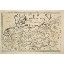
Das alte Germanien oder Teutschland.
From 'Algemeine Welthistorie (der Neuern Zeiten)', edited by S.J.Baumgarten, J.S.Semler a.o.A map of ancient Germany.
Date: Halle, 1763-1792
Selling price: ????
Please login to see price!
Sold in 2010
L \' Asie Divisee en ses Empires, Royaumes et Etats.
Jan Berend Elwe. Amsterdam-based publisher. Published a pocket-atlas of the Netherlands (1786) and of Germany (1791). Publised in 1792 a folio-atlas with 37 maps.Topograp...
Date: Amsterdam, 1792
Selling price: ????
Please login to see price!
Sold in 2011
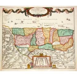
Generaale Kaart van het Beloofde Land.
Jan Berend Elwe. Amsterdam-based publisher. Published a pocket-atlas of the Netherlands (1786) and of Germany (1791). Publised in 1792 a folio-atlas with 37 maps.
Date: Amsterdam, 1792
Selling price: ????
Please login to see price!
Sold
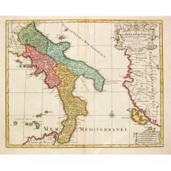
Le Royaume de Naples.
Map of the southern part of Italy, with garlands supported by cherubs.
Date: Amsterdam, 1792
Selling price: ????
Please login to see price!
Sold in 2017
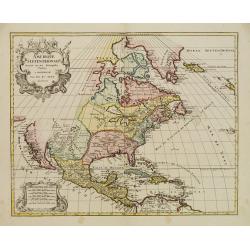
Amerique Septentrionale..
Richly embellished map of North America. Based on the Sanson map, which was the first to include all five Great Lakes. California now attached to the mainland. With a lar...
Date: Amsterdam 1792
Selling price: ????
Please login to see price!
Sold
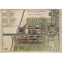
Grundriss von der Stadt und dem Schlosse Batavia.
From 'Algemeine Welthistorie (der Neuern Zeiten)'.
Date: Halle, 1763-1792
Selling price: ????
Please login to see price!
Sold in 2017
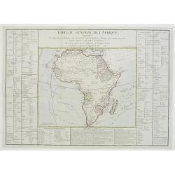
Tableau général de L'Afrique..
Map showing the tracks of Cook (1771-73, 1771 and Clarcke (1779). Surrounded by geographical information for each part of the continent along with useful statistical info...
Date: Paris 1792
Selling price: ????
Please login to see price!
Sold