Browse Listings
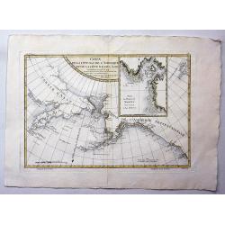
Carte de la Cote N.O. de L'Amerique et de la Cote N.E. de l' Asie.
Map of the north Pacific with Alaska, engraved by André. This is the general map of the Northwest Coast from the atlas volume of the first French edition of Cook's third...
Date: Paris, 1785
Selling price: ????
Please login to see price!
Sold in 2021
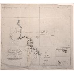
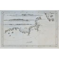
Map of Kerguelen's Land called by Capt. Cook Island of Desolation
A small engraved nautical chart. Relief shown by hachures and pictorially Below the cartouche the inscription: NB. The Shaded Coast is from the English the unshaded fro...
Date: London, 1785
Selling price: ????
Please login to see price!
Sold in 2016
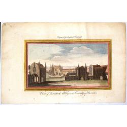
View of Tavistock Abby in the County of Devon.
The engraver and publisher are unknown but this fine hand-colored copper engraving was engraved for "ENGLAND DISPLAYED".
Date: London, 1785
Selling price: ????
Please login to see price!
Sold in 2015
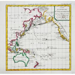
Carte de toutes les N.les Découvertes dans la Mer du Sud, ou est tracee la Route du Celebre Capitain Cook.
An attractive small map of the Pacific with the tracks of Captain Cook's last voyage made in 1777-79.
Date: Paris, c.1785
Selling price: ????
Please login to see price!
Sold in 2017
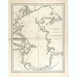
Carte de la Mer Caspienne 1785.
Large and detailed chart, with numerous soundings, as mapped by Jean Antoine Guldenstaedt (1745-1781), a Russian naturalist, who surveyed the area in 1771-1773. Engraved ...
Date: Paris, Dezauche, ca 1785
Selling price: ????
Please login to see price!
Sold in 2021

The Pope With the Cross / The Pope at the Close of the Holy Gate Jubilee. (Lot of 2 engeravings)
Two fine copper engraved prints featuring images of the Pope. From Dr. Hurd's "RELIGIOUS RITES & CEREMONIES OF ALL NATIONS". Featuring extremely fancy engra...
Date: London, c1785
Selling price: ????
Please login to see price!
Sold in 2015
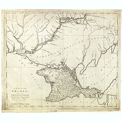
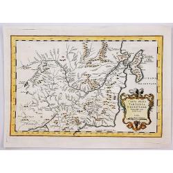
A Map Of The Crimea, And Of Tartary In Europe, From The Latest Surveys Of The Russian Army.
Shows "European Nogoyan Tartars" between well-detailed Crimea and the Dniepr River. To the north of that river there is "Part of the new acquired Russian T...
Date: London, June 30, 1785
Selling price: ????
Please login to see price!
Sold in 2015
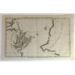
Chart of Cook's Strait in New Zealand.
Fine copperplate map of Captain Cook's discovery of New Zealand on hos first voyage of 1768. In 1770 he entered a deep water inlet and named it Queen Charlotte Sound and ...
Date: London, 1785
Selling price: ????
Please login to see price!
Sold in 2015
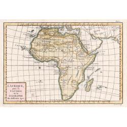
Carte L'AFRIQUE pour La Concorde de la Geographie des Differens Ages.
A beautiful small map of Africa By Jean Lattre. Published in Noel-Antoine Pluche's "Concorde de la Geographie des Differens Ages".
Date: Paris 1785
Selling price: ????
Please login to see price!
Sold in 2015
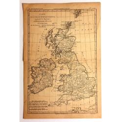
Carte des Isles Britanniques
Detailed map featuring all of Britain including the Shetland Islands. Rigobert Bonne (1727–1795) was one of the most important cartographers of the late 18th century. I...
Date: Paris, 1785
Selling price: ????
Please login to see price!
Sold in 2015
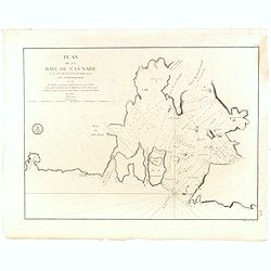
Plan de la Baye de St. Lunaire a la Cote du Nord-Est de Terre-Neuve Leve Geometriquement en 1784 . . .
Fine sea of the northeast coast of Newfoundland. The chart was drawn by and shows the surveys of Capt. Granchain, Capitaine des Vaisseaux du Roi.Relief shown by hachures...
Date: Paris, 1785
Selling price: ????
Please login to see price!
Sold in 2016
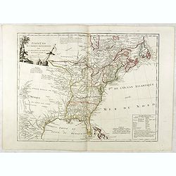
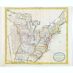
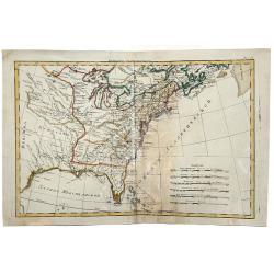
ETATS-UNIS DE L'AMÉRIQUE SEPTENTRIONALE Avec LES ISLES ROYALE, DE TERRE NEUVE...
Scarce early map of the newly created United States, with a note which includes 10 new proposed states proposed by Thomas Jefferson--Silvania, Michigania, Chersonesus, Ar...
Date: Paris, 1785
Selling price: ????
Please login to see price!
Sold in 2016
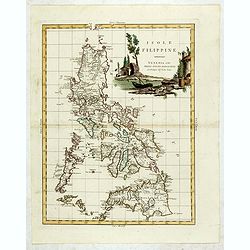
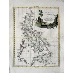
Isole Filippine.
One of the most decorative and sought after separate maps of the Philippines, based on the very rare map of Velarde. Covers all of the islands with remarkable detail. Dec...
Date: Venise, 1785
Selling price: ????
Please login to see price!
Sold in 2015
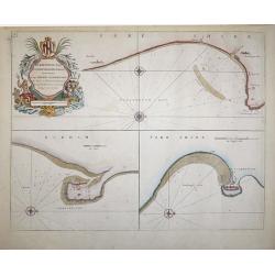
Burlington Bay, Scarbrough & Hartlepoole - To Capt. Ralph Sanderson this chart is dedicated and presented by Capt. Greenvile Collins, Hydrogr. to the King
From Great Britain's Coasting Pilot, by Captain Greenville Collins, Hydrographer in ordinary to the King's most Excellent Majesty.This sea chart is divided into three vie...
Date: London, 1785
Selling price: ????
Please login to see price!
Sold in 2018
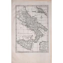
Naples en Sicilie
A rare map by Willem Bachiene, based on a previous map by R. Bonne. It depicts southern Italy, Sicily,and part of the coasts east of the Adriatic Sea.
Date: Amsterdam, 1785
Selling price: ????
Please login to see price!
Sold in 2018
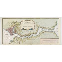
Plan van de Reede van Livorno
A rare map showing part of northern Italy and, in some detail, the sea area next to Livorno. From Willem Bachiene.
Date: Amsterdam, 1785
Selling price: ????
Please login to see price!
Sold in 2020
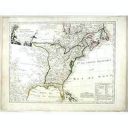
ETATS-UNIS DE L'AMÉRIQUE SEPTENTRIONALE Avec LES ISLES ROYALE, DE TERRE NEUVE...
Scarce early map of the newly created United States, with a note which includes 10 new proposed states proposed by Thomas Jefferson--Silvania, Michigania, Chersonesus, Ar...
Date: Paris, 1785
Selling price: ????
Please login to see price!
Sold in 2020
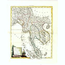
Regni D'Aracan Del Pegu Di Siam Di Camboge E Di Laos . . . 1785.
Striking regional map, extending from the Philippines and Moluccas to India and the Maldives, and north to Tibet. Decorative scroll title cartouche.
Date: Venise, 1785
Selling price: ????
Please login to see price!
Sold in 2017
Sketch of the Typa and Macao.
A map of the environs of the Portuguese settlement of Macao in the Far East. The map shows a small town plan of Macao, nearby rocks, shoals depth soundings, and a few nav...
Date: London, 1785
Selling price: ????
Please login to see price!
Sold in 2020
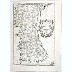
Royaume de Corée.
One of the earliest separate maps of Korea. The map engraved by the master engraver Delahaye, with a quite elaborately pictorial cartouche, engraved by G.Kondet. Jean Bap...
Date: Paris, Ph.-D. Pierres, Clousier [- Moutard], 1785
Selling price: ????
Please login to see price!
Sold in 2017
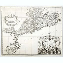
Province de Quang-Tong.
Very detailed map of Hong Kong and its surroundings.The map engraved by the master engraver Delahaye, with a quite elaborately pictorial cartouche, engraved by D. Sorniqu...
Date: Paris, Ph.-D. Pierres, Clousier [- Moutard], 1785
Selling price: ????
Please login to see price!
Sold in 2017
Carte la plus generale et qui comprend la Chine, la Tartarie chinoise et le Thibet. . .
With a quite elaborately pictorial cartouche, engraved by G.Kondet. Very detailed map of China, Tibet and Korea. Jean Baptiste Bourguignon d' Anville (1697-1782), French ...
Date: Paris, Ph.-D. Pierres, Clousier [- Moutard], 1785
Selling price: ????
Please login to see price!
Sold in 2017
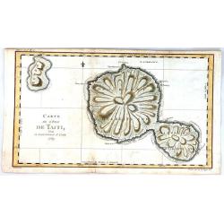
Carte de l'isle de Tahiti.
This chart of the islands of Tahiti is from James Cook’s first voyage, and is one of the earliest depicting the island.It is engraved to show the islands unique mountai...
Date: London, 1785
Selling price: ????
Please login to see price!
Sold in 2017
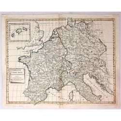
Imperium Caroli Magni Occidentis Imperatoris.
A detailed map of the Empire of Charlemagne covering Germany, France, Belgium, the Netherlands, Switzerland, Austria, Italy and Corsica. Issued as part of Antonio Zatta's...
Date: Venice, 1785
Selling price: ????
Please login to see price!
Sold in 2018
Sketch of the Typa and Macao.
A map of the environs of the Portuguese settlement of Macao in the Far East.
Date: London, 1785
Selling price: ????
Please login to see price!
Sold in 2018
Carte de la Tartarie Orientale Manchuria China.
A fine copperplate map of Manchuria China and parts of Siberia Russia by the cartographer Bellin in Paris in 1785. It is from the Italian edition.It features a decorative...
Date: Paris, 1785
Selling price: ????
Please login to see price!
Sold in 2019
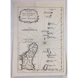
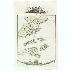
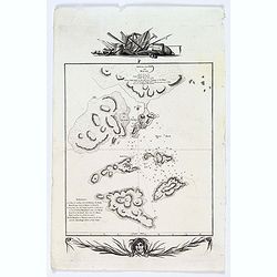
Carta Dell Arcipelago di s. Lazzaro ov. le Isole Marianne.
One of the oldest know maps of Guam and the Mariana Islands by the cartographer Bellin, published in Paris in 1785. It is from the Italian edition. It features a decorati...
Date: Paris, 1785
Selling price: ????
Please login to see price!
Sold in 2019
Plan de la Baye de l'Acul ( 5 plans on one sheet).
Revolutionary war sea chart with 5 plans of harbours at Santa Domingo in the Caribbean.Relief shown by hachures. Depths shown by soundings. Below engraved seal of Depot G...
Date: Paris, 1785
Selling price: ????
Please login to see price!
Sold in 2020
Carte de L' ile de Fogo à la Cote Orientale de Terre-Neuve. . .
Revolutionary war sea of Fogo Island, the largest of the offshore islands of Newfoundland and Labrador, Canada. It lies off the northeast coast of Newfoundland. Fogo Isl...
Date: Paris, 1785
Selling price: ????
Please login to see price!
Sold in 2018
A Map of the United States of America Agreeable to the Peace of 1783.
An unusual map of the United States issued shortly after the end of the American Revolutionary War. The map depicts the United States according to the 1783 Treaty of Pari...
Date: London, 1785
Selling price: ????
Please login to see price!
Sold in 2018
Unique world atlas by Louis Joseph Mondhare.
The atlas seems to be an attempt to publish a folio world atlas, maybe on Pierre Jean’s initiative. So far, it is the only known example of a folio world atlas publishe...
Date: Paris, ca. 1785
Selling price: ????
Please login to see price!
Sold in 2018
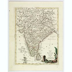
Stato del Mogol con l' Isole di Ceilan e Maldive.
A handsome map of India including Sri Lanka and the Maldives islands.
Date: Venice, 1785
Selling price: ????
Please login to see price!
Sold in 2018
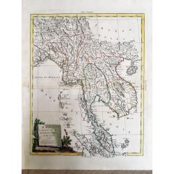
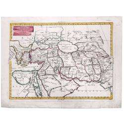
Regni D'Aracan Del Pegu Di Siam Di Camboge E Di Laos.
An elegant map with a decorative cartouche.
Date: Venice, 1785
Selling price: ????
Please login to see price!
Sold in 2019
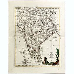
Stato del Mogol con l' Isole di Ceilan e Maldive.
A handsome map of India including Sri Lanka and the Maldives islands. With a nice decorative title cartouche in lower right corner. This lovely map incorporates plenty of...
Date: Venice, 1785
Selling price: ????
Please login to see price!
Sold in 2019
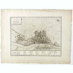
Varsovie.
Important early plan of Warsaw, based upon the 4-sheet plan of Warsaw by Pierre Ricaud de Tirregaille (1725-1770) who was a French Architect and Engineer. Tirregaille cam...
Date: Paris, ca. 1785
Selling price: ????
Please login to see price!
Sold in 2019
General Charte. In welcher alle Entdeckung welche der Captain Jacob Cook...
Very large and rare map of the world showing the tracks of Captain Cook on his three famous voyages. Centered on Australia and New Zealand, with many interesting notes an...
Date: Berlin, 1785
Selling price: ????
Please login to see price!
Sold in 2019
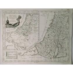
Terra di Canaan & Le Dodeci Tribu D'Isdraele.
An interesting Holy Land map with two parts, Israel with Canaan inserted to the top left. Filled with details of roads, towns and pictorial topography. The map features t...
Date: Venice, 1785
Selling price: ????
Please login to see price!
Sold in 2019
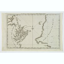
Chart of Cook's Strait in New Zealand.
An early and important map of Cook's Strait, which separates the North and South islands of New Zealand. Shows the area of present day Wellington, Marlborough Sounds, and...
Date: London, 1785
Selling price: ????
Please login to see price!
Sold in 2019
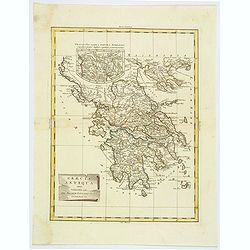
Graecia Antiqua.
A detailed map of Ancient Greece and contiguous Islands and countries. Issued as part of Zatta's Atlante Novissimo. Inset of northern Greece. Pretty title cartouche.
Date: Venice, 1785
Selling price: ????
Please login to see price!
Sold in 2019
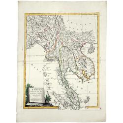
REGNI D'ARACAN DEL PEGU DI SIAM DI CAMBOGE E DI LAOS.
A striking engraved map of Burma, Thailand, Cambodia, Vietnam, Hainan, Straits of Malaca, the Malay Peninsula, and parts of Sumatra. Also with the Andaman, Nicobar, and M...
Date: Venice, 1785
Selling price: ????
Please login to see price!
Sold in 2019
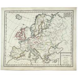
L'Europe Divissee en Ses Principales Parties et Leurs Capitales.
A striking, highly detailed, fine and unusual 1785 Mentelle copper engraved map of the whole European Continent. The map is filled with good topographic details as well a...
Date: Paris, 1785
Selling price: ????
Please login to see price!
Sold in 2019
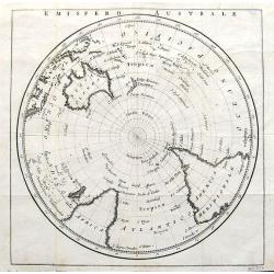
Emisfero Australe.
A rare Italian map of the Southern Hemisphere and South Pole. Apparently published shortly after the voyages of Captain Cook, as the coastlines of New Zealand are quite a...
Date: ca 1785
Selling price: ????
Please login to see price!
Sold in 2019
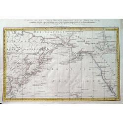
Carte de la partie septentrionale de la Mer du Sud, comprise entre la Californie, les Isles Sandwich, le Japon et le Détrt. de Behring.
An unusual map of the northern Pacific, based upon the explorations of James Cook during his third voyage. Hawaii (Sandwich Islands) are shown, as is the coasts of the No...
Date: Paris, ca 1785
Selling price: ????
Please login to see price!
Sold in 2019
ALEXANDER THE GREAT, Imperium ALEXANDRI MAGNI Per Europam, Asiam, et Africam.
A detailed map of the Empire of Alexander the Great, extending from Asia Minor and Greece to the regions around the Black Sea and Capian Sea, reaching the Indus River in ...
Date: Venice, 1785
Selling price: ????
Please login to see price!
Sold in 2022
(Russian World Map, Double Hemisphere, after Janvier).
A very rare, double hemisphere World map with Russian text/imprint. With a lovely decorative title cartouche.
Date: St. Petersburg, 1785
Selling price: ????
Please login to see price!
Sold in 2020
(Russian map showing UNITED STATES, after Janvier).
An exceptionally rare, Russian map showing the eastern portion of the United States, after the popular map by Janvier. Text/imprint in Russian.
Date: St. Petersburg, 1785
Selling price: ????
Please login to see price!
Sold in 2020
Planisphere Physique ou l'on du Pole Septentrional.
Uncommon world map on a north pole projection prepared by G.de l'Isle and published by Phil. Dezauche.This map is most notable for it's depiction of "Mer de L'Ouest&...
Date: Paris, 1785
Selling price: ????
Please login to see price!
Sold in 2020
Byzonder Ontwerp van zommige der Voornaamste Africaansche Eilanden zo in de Middellandsche als Atlantische en Ethiopische Zeeën
Uncommon map showing islands in the Midstream and Atlantic Ocean, from J. van Jagen and published in, "Atlas, tot opheldering der hedendaagsche historie, ... door W....
Date: Amsterdam, Matthijs Schalekamp, 1785
Selling price: ????
Please login to see price!
Sold in 2022
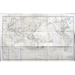
Carte générale offrant les découvertes faites par le capitaine Jacques Cook dans ce voyage et dans les deux voyages précédens, ainsi que la route des vaisseaux qu'il commandoit / Par Henri Robert, lieutenant de la Marine du Roi.
World map centered on the Pacific Ocean, from " A New, Authentic and Complete Collection of Voyages Round the World…Complete Historical Account of Captain Cook's F...
Date: Paris, 1785
Selling price: ????
Please login to see price!
Sold in 2020
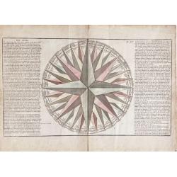
Des Vents (compass rose)
Very decorative compass rose. It includes 32 directional points and many vother details. Note that this is one of the largest compass rose images ever appeared in an atla...
Date: Paris, 1785
Selling price: ????
Please login to see price!
Sold in 2020
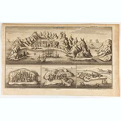
La Ville d'Aden. Mombaze. Quiloa. St. George de la Mine.
Eye-bird view of Aden city in Yemen, with Mombaze, Quiloa and St Georges Mine. Joseph-François Lafitau, born and died in Bordeaux, France, is a Jesuit missionary in New...
Date: Paris, 1785
Selling price: ????
Please login to see price!
Sold in 2020
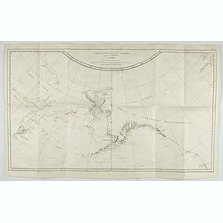
Carte de la Cote N.O. de l'Amerique et de la Cote N.E. de l'Asie, Reconnues en 1778 et 1779. Les parties de la Cote d'Asie qui ne sont pas ombrees sont tirees d'une Carte Manuscrite que nous donnerent les Russes.
Map of the North Pacific and contiguous coastlines of Alaska and Russia, published in the first French edition of the official account of James Cook's Third Voyage. The ...
Date: Paris, 1785
Selling price: ????
Please login to see price!
Sold in 2022

Temple of Baal.
Bible illustration from the "book of kings", engraved by Johan Galle, and edited by Spanoghe in 1785 at Antwerp.
Date: Antwerpen 1785
Selling price: ????
Please login to see price!
Sold
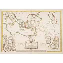
Carte des Régions et des Lieux dont il est parle..
Covers the region of the eastern Mediterranean through the Caspian Sea, showing the region described in the New Testament. Inset plans of Jerusalem and Judea. Three decor...
Date: Paris 1785
Selling price: ????
Please login to see price!
Sold
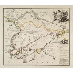
Kaart van het Noordlijk gedeelte van Bresil.
Uncommon and attractive map of most of Brazil. The directions of the trade winds are shown. Very nice detail of the river systems, mines, forts, missions, and villages. A...
Date: Amsterdam 1785
Selling price: ????
Please login to see price!
Sold
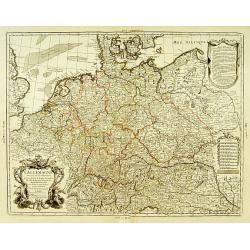
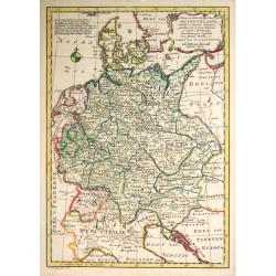
L'Allemagne dressée sur les observations..
Map of Germany, Low Countries, Poland, Switzerland, Northern Italy. Prepared by G.De L'Isle after observations by Kepler and Tycho Brahe.Engraved by Jean Batiste Liébaux...
Date: Paris, 1785
Selling price: ????
Please login to see price!
Sold in 2016
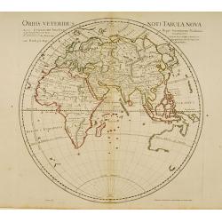
Orbis Veteribus Noti Tabula Nova.
Ancient map of the Eastern Hemisphere, with the outline of western Australia shown, Madagascar under its old name (Menuthias Island).On this map Hokkaido is even bigger d...
Date: Paris, 1785
Selling price: ????
Please login to see price!
Sold in 2018
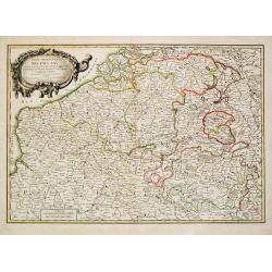
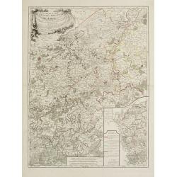
Partie Meridionale des Pays Bas Comprenant les provinces de brabant, Gueldre, Limbourg, Luxembourg, Haynaut, Namur, Flandre, Cambresis et Artois.
A map of Belgium and Luxembourg. Embellished with an attractive title-cartouche.
Date: Paris, 1785
Selling price: ????
Please login to see price!
Sold in 2010
Kaart van Duitschland
Willem Albert Bachiene (1712-1783), Dutch geographer in Maastricht. Most important work ' Heilige Geographie', a work on the Holy Land. Mathijs Schalenkamp published in 1...
Date: Amsterdam, 1785
Selling price: ????
Please login to see price!
Sold in 2013
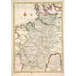
Kaart der Noord-westelijke deelen van Duitschland.
Willem Albert Bachiene (1712-1783), Dutch geographer in Maastricht. Most important work ' Heilige Geographie', a work on the Holy Land. Mathijs Schalenkamp published in 1...
Date: Amsterdam, 1785
Selling price: ????
Please login to see price!
Sold in 2013

Venerunt pastores.
Copper engraving, showing the birth of Christ. With decorative borders. Title page to the New Testament, edited by Spanoghe in Antwerp 1785.
Date: Antwerp 1785
Selling price: ????
Please login to see price!
Sold
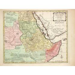
Nubie et Abissinie.
Willem Albert Bachiene (1712-1783), Dutch geographer in Maastricht. Most important work ' Heilige Geographie', a work on the Holy Land. Mathijs Schalenkamp published in 1...
Date: Amsterdam, 1785
Selling price: ????
Please login to see price!
Sold
LIEGE,
Map of the princedom of Liege and part of the Dutch province Limburg, with the cities of Maastricht and Liege in the centerpart of the map. An inset map represents the e...
Date: Paris 1785
Selling price: ????
Please login to see price!
Sold
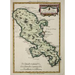
Kaart van het eiland Martinique.
Willem Albert Bachiene (1712-1783), Dutch geographer in Maastricht. Most important work ' Heilige Geographie', a work on the Holy Land. Mathijs Schalenkamp published in 1...
Date: Amsterdam, 1785
Selling price: ????
Please login to see price!
Sold
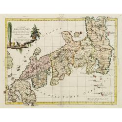
L'Impero del Giapon diviso in sette principali parti cive..
The map of the Japanese Empire published by Antonio Zatta (1757-97) continued to show most of the inaccuracies of earlier eighteenth-century maps.
Date: Venice 1785
Selling price: ????
Please login to see price!
Sold in 2008
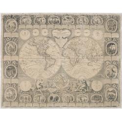
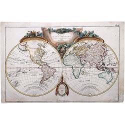
Carte Générale de la Terre ou Mappe Monde avec les quatre principaux sistemes.
Uncommon and dramatically composed world map, prepared by Clouet. Two mythological figures supporting the two hemispheres. With superb decoration including a wonderful ro...
Date: Paris, Mondhare, 1785
Selling price: ????
Please login to see price!
Sold
![[2 maps] Parte Occidentale del Regno di Boemia Di Nuova Projezione.. / Parte Occidentale del Regno di Boemia Di Nuova Projezione..](/uploads/cache/23642-250x250.jpg)
[2 maps] Parte Occidentale del Regno di Boemia Di Nuova Projezione.. / Parte Occidentale del Regno di Boemia Di Nuova Projezione..
Depicting what is now the Czech Republic as far East as Prague. Embellished with a title vignette lower left corner.Engraved by G. Zuliani after the drawing by G. Pitteri...
Date: Venice 1785
Selling price: ????
Please login to see price!
Sold
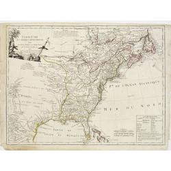
ETATS-UNIS / DE L'AMÉRIQUE SEPTENTRIONALE / Avec / LES ISLES ROYALE, DE TERRE NEUVE, / DE S.T JEAN, L'ACADIE, &c. / 1785. / Supplement a l'Atlas de M. Robert de Vaugondy. / a Paris Ches Boudet Ingenieur du Roi.
Rare early map of the newly created United States with the variant imprint of Boudet. The map is highly detailed, extending to the Rio Grande and including notes on the S...
Date: Paris 1785
Selling price: ????
Please login to see price!
Sold

The Toco.
Hand colored copper engraving representing a Toco Toucan carrying a fruit with his beak from General Synopsis of Birds by John A. Latham (1740?1837) who was the pre?emine...
Date: London 1781-1785
Selling price: ????
Please login to see price!
Sold in 2017
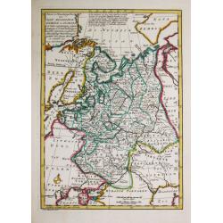
Het Russische gebied in Europa. 1778.
Willem Albert Bachiene (1712-1783), Dutch geographer in Maastricht. Most important work ' Heilige Geographie', a work on the Holy Land. Mathijs Schalenkamp published in 1...
Date: Amsterdam, 1785
Selling price: ????
Please login to see price!
Sold
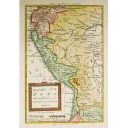
Kaart van Peru, Met een gedeelte van de Landen ten oosten gelegen.
Willem Albert Bachiene (1712-1783), Dutch geographer in Maastricht. Most important work ' Heilige Geographie', a work on the Holy Land. Mathijs Schalenkamp published in 1...
Date: Amsterdam, 1785
Selling price: ????
Please login to see price!
Sold in 2008
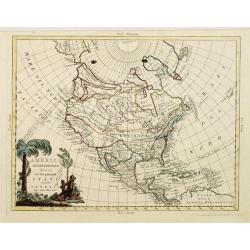
America settentrionale divisa ne'suoi principali stati.
Decorative and detailed map of North America, with some Contemp. manuscript notations in the Pacific.The map includes a notation of a Chinese Colony Fou Sang, based upon ...
Date: Venise, 1785
Selling price: ????
Please login to see price!
Sold in 2012
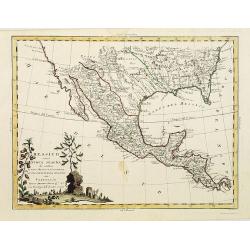
Messico ouvero Nuova Spagna che contiene Il Nuova Messico La California con una Parte de Paesi Adjacenti. . .
Decorative and detailed map of the southern part of the United States, Mexico and Central America. The map is filled with remarkable detail throughout, particularly in Te...
Date: Venise, 1785
Selling price: ????
Please login to see price!
Sold in 2019
Isole Filippine
Important large map of the Philippines by Zatta published in his "Atlante Novissimo". Very detailed with even tiny islands shown and named. Decorative title car...
Date: Venice, 1785
Selling price: ????
Please login to see price!
Sold in 2008
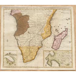
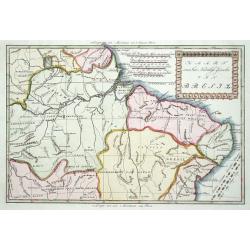
Carte de l'Afrique Méridionale, ou Pays entre la Ligne et le Cap de Bonne Espérance.
Africa south of the Equator, with insets of Table Mountain, Table Bay and the Cape of Good Hope (based on Valentyn). Originally the plate of De L'Isle of 1708, this image...
Date: Amsterdam, ca. 1785
Selling price: ????
Please login to see price!
Sold in 2008
Carte de la ville de constantinople et du Bosphore de thrace 1785.
Detailed plan of Istanbul and the river Bosporus till the Black Sea. Taken from a larger map published by P.F. Tardieu and engraved by J. B. L. Aubert.
Date: Paris, 1785
Selling price: ????
Please login to see price!
Sold in 2008
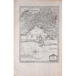
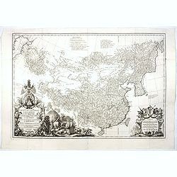
Carte de la Petite Tartarie Dresee par ordre de l'Imperatries de toutes las Russies.
Very rare first edition of De Leth's map of the southern part of Ukraine, with detailed annotations regarding the Cosaks and an explanatory key. Based on a Russian map, t...
Date: Amsterdam, ca. 1785
Selling price: ????
Please login to see price!
Sold in 2022
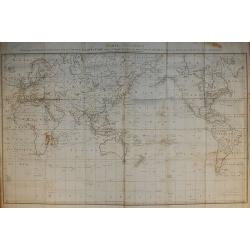
Carte Générale Offrant les Découvertes faites par le Capitaine Jacques Cook dans ce Voyage et dans les deux Voyages précédens ...
From the French edition of James Cook's third voyage entitled Troisième Voyage de Cook, ou Voyage à l'Océan Pacifique, ordonné par le Roi d'Angleterre, pour faire des...
Date: Paris, 1785
Selling price: ????
Please login to see price!
Sold in 2010
Carte de la Terre Van-Diemen.
From the French edition of James Cook's third voyage entitled Troisième Voyage de Cook, ou Voyage à l'Océan Pacifique, ordonné par le Roi d'Angleterre, pour faire des...
Date: Paris, 1785
Selling price: ????
Please login to see price!
Sold in 2010

Danse d'O-taïti.
From the French edition of James Cook's third voyage entitled Troisième Voyage de Cook, ou Voyage à l'Océan Pacifique, ordonné par le Roi d'Angleterre, pour faire des...
Date: Paris, 1785
Selling price: ????
Please login to see price!
Sold in 2010