Browse Listings
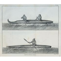
Canots d'Oonalashka.
From the French edition of James Cook's third voyage entitled Troisième Voyage de Cook, ou Voyage à l'Océan Pacifique, ordonné par le Roi d'Angleterre, pour faire des...
Date: Paris, 1785
Selling price: ????
Please login to see price!
Sold in 2010
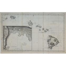
Carte des Isles Sandwich.
From the French edition of James Cook's third voyage entitled Troisième Voyage de Cook, ou Voyage à l'Océan Pacifique, ordonné par le Roi d'Angleterre, pour faire des...
Date: Paris, 1785
Selling price: ????
Please login to see price!
Sold in 2010
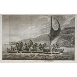
Pirogue des Isles Sandwich, avec les rameurs masqués.
From the French edition of James Cook's third voyage entitled Troisième Voyage de Cook, ou Voyage à l'Océan Pacifique, ordonné par le Roi d'Angleterre, pour faire des...
Date: Paris, 1785
Selling price: ????
Please login to see price!
Sold in 2010

Homme masqué de l'Isle Sandwich.
From the French edition of James Cook's third voyage entitled Troisième Voyage de Cook, ou Voyage à l'Océan Pacifique, ordonné par le Roi d'Angleterre, pour faire des...
Date: Paris, 1785
Selling price: ????
Please login to see price!
Sold in 2010
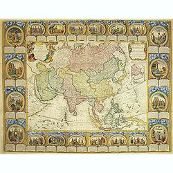
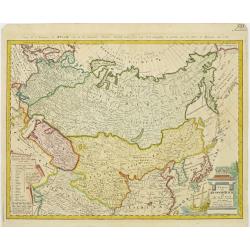
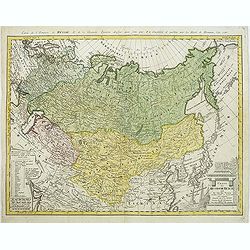
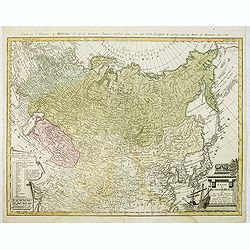
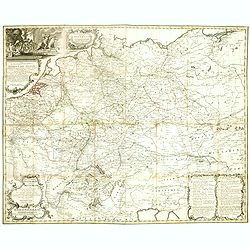
Carte D'Asie Divisée en ses Principaux Etats. . .
Uncommon and decorative "carte à figures" wall map, prepared by Cloued, with superb decoration. The map is interesting as it shows Korea in the d'Anville type ...
Date: Paris, 1785
Selling price: ????
Please login to see price!
Sold
Atlas de Toutes les Parties Connues du Globe Terrestre, dressé pour l'Histoire Philosophique & Politique des Etablissemens & du Commerce des Européens dans les deux Indes.
Illustrated with 50 fine uncolored copper plate maps and 23 fold out tables. All maps have centerfold, except for plate I ("L'Ancien Monde et le Nouveau en Deux Hemi...
Date: Geneve, J.L. Pellet, 1785
Selling price: ????
Please login to see price!
Sold in 2010
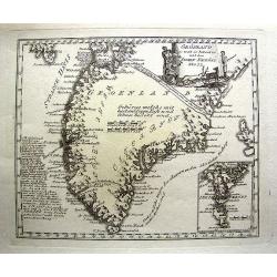
Grönland so weit es bekant ist mit den Inseln Faeröer No 77.
Unusual German map of Greenland, with parts of Iceland. A small inset map of the Faroe Islands. One of the most detailed map of Greenland at its time, with many place nam...
Date: Vienna, c1785
Selling price: ????
Please login to see price!
Sold in 2013
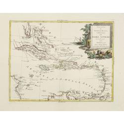
Stabilimenti de Francesi, Inglesi, E Spagnuoli nelle Isole Antille. . .
Scare map of Caribbean, including Florida, Bahamas and coast of Venezuela, including Curacao, Artiba I, Buenayre , etc. Engraved by G.Pitteri.
Date: Venice, 1785
Selling price: ????
Please login to see price!
Sold in 2011
America settentrionale divisa ne\'suoi principali stati.
Decorative and detailed map of North America, with some Contemp. manuscript notations in the Pacific.The map includes a notation of a Chinese Colony Fou Sang, based upon ...
Date: Venise, 1785
Selling price: ????
Please login to see price!
Sold in 2011
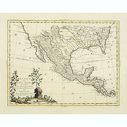
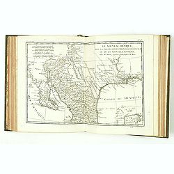
Messico ouvero Nuova Spagna che contiene Il Nuova Messico La California con una Parte de Paesi Adjacenti. . .
Decorative and detailed map of the southern part of the United States, Mexico and Central America. The map is filled with remarkable detail throughout, particularly in Te...
Date: Venise, 1785
Selling price: ????
Please login to see price!
Sold in 2011
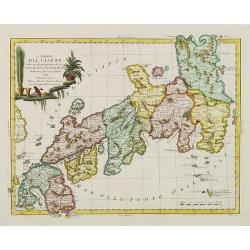
L'Impero del Giapon diviso in sette principali parti cive..
The map of the Japanese Empire published by Antonio Zatta (1757-97) continued to show most of the inaccuracies of earlier eighteenth-century maps.
Date: Venice, 1785
Selling price: ????
Please login to see price!
Sold in 2011

Planisphere Physique ou l'on du Pole Septentrional.
Uncommon world map on a north pole projection prepared by G.de l'Isle and published by Phil. Dezauche.This map is most notable for it's depiction of "Mer de L'Ouest&...
Date: Paris, 1785
Selling price: ????
Please login to see price!
Sold in 2011
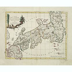
L' Impero del Giapon diviso in sette principali parti cioè Ochio Quanto Jetsegen Jetsen Jamaisoit, Xicoco e Xmo. . .
The map of the Japanese Empire published by Antonio Zatta (1757-97) continued to show most of the inaccuracies of earlier eighteenth-century maps.To the left the tip of S...
Date: Venice, 1785
Selling price: ????
Please login to see price!
Sold in 2015
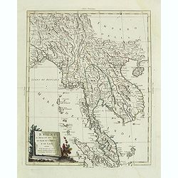
Regni D'Aracan Del Pegu Di Siam Di Camboge E Di Laos . . . 1785
Striking map of the region from the Gulf of Bengal to Hainan, centered on the Malay Peninsula, Straits of Malacca and most of Sumatra.The map was issued in Zatta's "...
Date: Venise, 1785
Selling price: ????
Please login to see price!
Sold in 2011
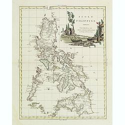
Isole Filippine.
One of the most decorative and sought after separate maps of the Philippines, based on the very rare map of Velarde. Covers all of the islands with remarkable detail. Dec...
Date: Venise, 1785
Selling price: ????
Please login to see price!
Sold in 2011
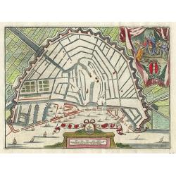
La ville D' Amsterdam.
Small bird's-eye plan of the city decorated with a vignette and title cartouche.
Date: Antwerp 1786
Selling price: ????
Please login to see price!
Sold
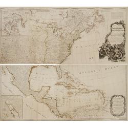
A new map of North America, with the West India Islands..
An important and grand map of the United States, printed on four joined sheets and at a very large-scale, extends to include all of known North America and the West Indie...
Date: London, 1763-1786
Selling price: ????
Please login to see price!
Sold

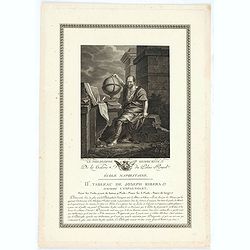
Casparus Barleus
Attractive portrait of the author of 'Rerum in Brasilia Gestarum Historia, 1647', with large scale map. Oversaw the maps in Herrera's Historia General, 1622.
Date: Amsterdam, 1786
Selling price: ????
Please login to see price!
Sold in 2008
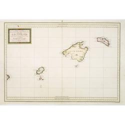
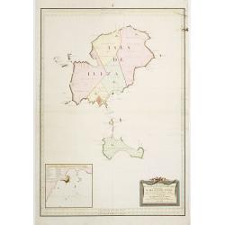
Carta Esferica de Las Yslas Baleares Y Pithyusas..
Rare chart of Majorca, Minorca and Ibiza. Prepared by Antonio Valdés. Engraved by Moreno Taxada. Detailed chart giving some soundings, place names and mountains.
Date: Madrid 1786
Selling price: ????
Please login to see price!
Sold
Carta Esferica de Las Islas de Iuizay.. (Ibiza)
Rare chart of Ibiza. Prepared by Antonio Valdés. Engraved by S.Brieva. Detailed chart giving soundings, place names and mountains. With inset plan Plano del Puerto de la...
Date: Madrid 1786
Selling price: ????
Please login to see price!
Sold
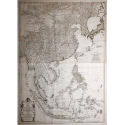
Zweiter Theil der Karte von Asien, welcher China, einen Theil der Taterei, Indien jenseits des Ganges, die Inseln Sumatra, Iava, Borneo, Moluken, Philippinen, und Iapon enthaelt.
In common large map of South East Asia, printed from 2 plates on 2 sheets joined, after d'Anville and other sources by F.A. Schraembl, Vienna "1786".
Date: Vienna, after 1786
Selling price: ????
Please login to see price!
Sold in 2013
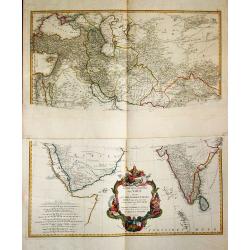
Erster Theil der Karte / von Asien / welche die Turkei, Arabien, Persien / Indien diesseits des Ganges / und einen Theil der Tartarei / anhalt.
A large and detailed map of the Middle East on two sheets. Embellished with a large decorative title-cartouche.
Date: Wien, 1786
Selling price: ????
Please login to see price!
Sold in 2019
A Map of Bengal, Bahar, Oude and Allahabad with Part of Agra and Delhi Exhibiting the Course of the Ganges from Hurdwar to the Sea..
Very large wall map extending from the Bay of Bengal in the South East as far as Tibet to the North and Gohud to the West.Engraved from the original drawing in the posses...
Date: London, 1786
Selling price: ????
Please login to see price!
Sold in 2022
Charte das Russische Reich und die von den Tatarn..
Map showing the 'Russian Tartary' and as well the 'Asian Tartary', with French title in top.Title cartouche in the lower right corner and a table of explanations relating...
Date: Nuremberg, 1786
Selling price: ????
Please login to see price!
Sold in 2009
Essai d'une nouvelle carte de la Mer Caspienne.
Map of the Caspian Sea including cities/towns and regions. Engraved by de master engraver Guill. De-la-Haye., dated "Novembre 1754". Jean Baptiste Bour...
Date: Paris, c. 1786
Selling price: ????
Please login to see price!
Sold in 2009
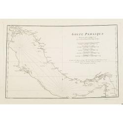
Golfe Persique Dressé en 1758 et publié en 76. . .
Map of the Persian Gulf including cities/towns and regions. Engraved by de master engraver Guill. De-la-Haye. Jean Baptiste Bourguignon d' Anville (1697-1782), French ca...
Date: Paris, c. 1786
Selling price: ????
Please login to see price!
Sold in 2009
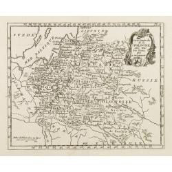
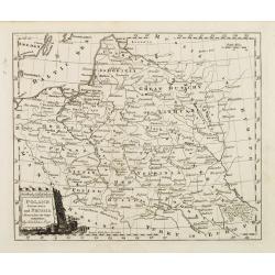
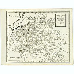
Carte de la Pologne avec tous les Etats, qui y son annexés.
Finely engraved small map of Poland. From Atlas Moderne ou Collection de Cartes sur Toutes les Parties du Globe Terrestre.
Date: Paris, 1786
Selling price: ????
Please login to see price!
Sold in 2008
Poland, Lithuania and Prussia Drawn from the latest Authorities by Thos. Kitchin Geogr.
Map showing the region along the Baltic Sea from Stettin to Riga. In the lower right is part of the course of the Dnieper river and part of Ukraine.To the right of the ti...
Date: Paris, 1786
Selling price: ????
Please login to see price!
Sold in 2008
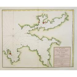
Carte Hidro-Topographique Des Entrées Et Ports du Férol Et De La Corogne..
Engraved by J. Dezauche.
Date: Paris, 1786
Selling price: ????
Please login to see price!
Sold in 2008
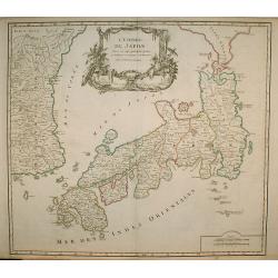
L' Empire Du Japon, divisé en sept principales . . .
Giles Didier Robert De Vaugondy's map of Japan in a second state, now with the date removed. Published by Charles Francois Delamarche, who acquired De Vaugondy's business...
Date: Paris, c. 1786
Selling price: ????
Please login to see price!
Sold in 2009
![[Untitled map of the Pacific and the Americas]](/uploads/cache/91430-250x250.jpg)
[Untitled map of the Pacific and the Americas]
Large German map of the Pacific Ocean, showing the tracks of the three voyages of Captain Cook in great detail. Seems to be the right part of a larger map. Engraved by H....
Date: Vienna, ca. 1786
Selling price: ????
Please login to see price!
Sold in 2010
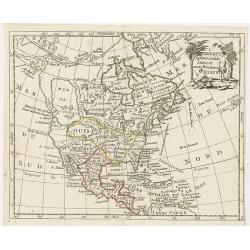
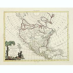
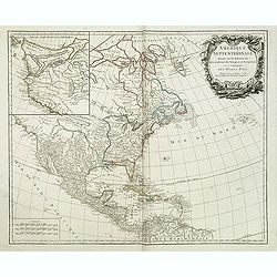
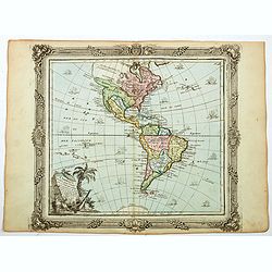
L'Amerique septentrionale divisee en ses principaux etats.
A scarce map of North America showing the principal American States and the possessions of Spain and France. Not in Mcguirk, Mer de l'OuestOf cartographic interest is the...
Date: Paris, 1786
Selling price: ????
Please login to see price!
Sold in 2021
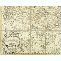
Neue und vollstaendige Postkarte durch ganz Deutschland. . . Carte des postes d'Allemagne partie du sud ouest. . .
The lower left part of a four sheet post road mapspost route map of Germany. Map showing the cities of Lyon, Chambery, Auxerre, Troyes, Luneville, Strasbourg, Basle, Bern...
Date: Nuremberg, 1786
Selling price: ????
Please login to see price!
Sold in 2017
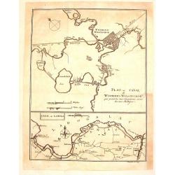
Plan du Canal de Wischnei-Wolotschok / Canal de Ladoga.
Two plans or maps on one page. The Canal Wischnei joins the Caspian and Baltic Seas. These canals are in European Russia.The map was engraved by Clauser and published by ...
Date: Geneva, 1786
Selling price: ????
Please login to see price!
Sold in 2015

1. Manakin à tête d'or. / 2. Manakin à tête blanche. / 3. Manakin rouge.
From Histoire naturelle des oiseaux.Drawn and engraved by Martinet from the bird section of Buffon's works.
Date: Paris, 1770-1786
Selling price: ????
Please login to see price!
Sold in 2011

Casoar, des Indes Orientales.
From Histoire naturelle des oiseaux.Drawn and engraved by Martinet from the bird section of Buffon's works.
Date: Paris, 1770-1786
Selling price: ????
Please login to see price!
Sold in 2011

Perruche à front jaune, de Cayenne.
From Histoire naturelle des oiseaux.Drawn and engraved by Martinet from the bird section of Buffon's works.
Date: Paris, 1770-1786
Selling price: ????
Please login to see price!
Sold in 2011
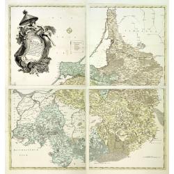
Magna mappa geographica Borrussiae Regnum exacte ehibens. . .
A scarce separately published wall map in 4 sheets of Prussia. Including the towns of Gdansk, Kaliningrad, Klaipeda, etc. Prepared by Gerhard and engraved by von Sauerbre...
Date: Berlin, c. 1772 - 1786
Selling price: ????
Please login to see price!
Sold in 2011
Charte das Russische Reich und die von den Tatarn. . .
Map showing the 'Russian Tartary' and as well the 'Asian Tartary', with French title in top.Title cartouche features a three-masted ship in the lower right corner and scr...
Date: Nuremberg, 1786
Selling price: ????
Please login to see price!
Sold in 2023
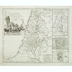
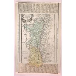
La Judée depuis le Retour de la Captivité, . . .
Decorative map of the Holy Land, with large insets of Ancient and Modern Jerusalem and the Holy Land at the time of the domination by the Turks. Large striking cartouche....
Date: Paris, Boudet, 1786
Selling price: ????
Please login to see price!
Sold in 2011
AMERIQUE SEPTENTRIONALE dressée sur les Relations les plus modernes des Voyageurs et Navigateurs ou se remarquent LES ETATS UNIS. . .
This large map of North America and the West Indies was originally published in 1750: however after the Treaty of Paris recognized the United States in 1783 the map was '...
Date: Paris, after 1786
Selling price: ????
Please login to see price!
Sold in 2011
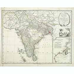
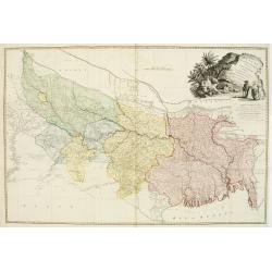
Presqu'Isle Des Indes Orientales, Comprenant l'Indostan ou l'Empire du Mogol. . .
Detailed map of India with inset map (220x155mm) of the mouth of the river Ganges. Identifies Delhi (or Jehan Abad), Agra (or Ekbar Abad), Bombay, Goa, Calcutta, Pondiche...
Date: Paris, Boudet, 1786
Selling price: ????
Please login to see price!
Sold in 2016
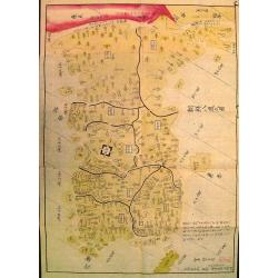
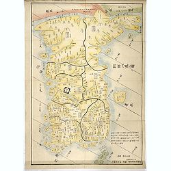
Chosen hachido no zu (or) Chosen koku zenzu (General map of korea)
Bold, beautifully colored road-map of Korea by the great Hayashi Shihei. Banned by the Edo government in 1792. A banned map !In 1785 Hayashi Shihei made the Sangoku Ts&am...
Date: Edo, Suharaya Shihei, in Temmei 5 or 1786
Selling price: ????
Please login to see price!
Sold
Charte das Russische Reich und die von den Tatarn. . .
Map showing the 'Russian Tartary' and the 'Asian Tartary', with the French title at the top. The title cartouche features a three-masted ship in the lower right corner,...
Date: Nuremberg, 1786
Selling price: ????
Please login to see price!
Sold in 2012
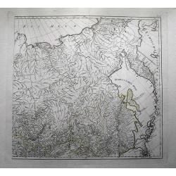
(untitled map of eastern Russia with Kamchatka )
Large and detailed map of eastern Russia with parts of Siberia including the lake Baikal by Franz Anton Schraembl (1751-1803). With a small part of today Mongolia and Chi...
Date: Vienna, c1786
Selling price: ????
Please login to see price!
Sold in 2012
Carte générale de la Pologne Avec tous les Etats qui y sont annexés.
Uncommon and detailed map of Poland prepared by C.Bertholon. Lithuania is shown and divided into Palatines. Plate No. 9 in: "Bibliotheque universelle des dames"...
Date: 1786
Selling price: ????
Please login to see price!
Sold in 2013
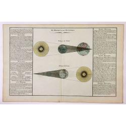
Du Zodiaque et de L'Eclyptique / Eclypse de Soleil / Eclypse de Lune.
A chart depicting the eclipse of the sun and moon with descriptive text on both sides. By De Mornas. Claude Buy de Mornas (d. 1783), was Géographe du roi (1764). He prod...
Date: Paris, 1786
Selling price: ????
Please login to see price!
Sold in 2019
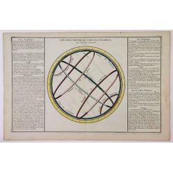
Colures, Tropiques, cercles Polaires, et Leurs Usages.
A chart depicting the tropics of cancer and capricorn, and the north and south poles with descriptive text on both sides. By De Mornas.Claude Buy de Mornas (d. 1783), was...
Date: Paris, 1786
Selling price: ????
Please login to see price!
Sold in 2019
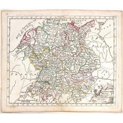
L'Allemagnedivissee par Cercles avec les Etats de Boheme et la Suisse.
A detailed map of the German states. Austria and Switzerland with Belgium part of Austria and Silesia as part of Prussia.
Date: Paris, 1786
Selling price: ????
Please login to see price!
Sold in 2016
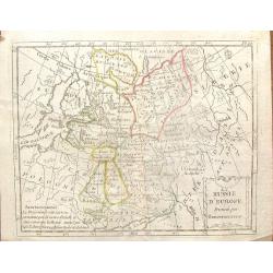
La Russie D'Europe, Divisee par Gouvernemens.
An interesting Russian map divided into its various provinces or oblasts. Note that Lapland was part of Russia at that time.The engraver was De La Porte and the map was p...
Date: Paris, 1786
Selling price: ????
Please login to see price!
Sold in 2016
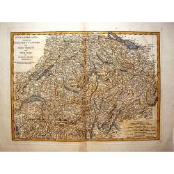
Switzerland Divided Into Thirteen Cantons.
A very detailed map of Switzerland by Samuel Dunn and published by Robert Sayer in London in 1786.
Date: London, 1786
Selling price: ????
Please login to see price!
Sold in 2016
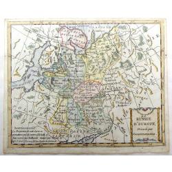
La Russie d'Europe, Divisee par Gouvernemens.
A map of Russia in Europe divided into its various provinces. Interestingly, the map shows Lapland as being governed by Russia. Includes Lithuania and Estonia.
Date: Paris, 1786
Selling price: ????
Please login to see price!
Sold in 2016
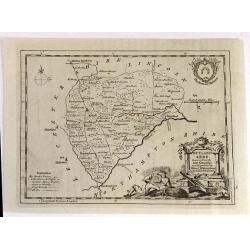
RUTLAND SHIRE, Drawn from the best Authorities
An attractive and neatly engraved 18th century map of Rutland, by Thomas Kitchin. It appeared in Henry Boswell's “Antiquities of England & Wales” in London publis...
Date: London, 1786
Selling price: ????
Please login to see price!
Sold in 2016
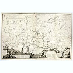
Carte Hydrographique des Etats de la Maison d'Autriche en deça du Rhin.
Rare wall map in four joined sheets which cover the Adriatic Sea north to Frankfurt and Dresden, from Dresden east to Prague and the Czech / Polish border and east from t...
Date: Vienna, ca.1786
Selling price: ????
Please login to see price!
Sold in 2016
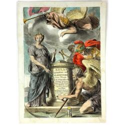
(Title page) Atlas General et Elementaire Pour L'Etude de la Geographie et de L'Histoire Moderne
A fine allegorical frontispiece from Sr. Desnos's "Atlas General et Elementaire Pour L'Etude de la Geographie et de L'Histoire Moderne." Published in Paris in 1...
Date: Paris, 1786
Selling price: ????
Please login to see price!
Sold in 2016
Neue und vollstaendige Postkarte durch ganz Deutschland. . . Carte des postes d'Allemagne partie du sud ouest. . .
A folding post route map of Germany, The Low Countries, Poland, Switzerland, Austria and Northern Italy. Typical for a post-route map the mail routes with distances and p...
Date: Nuremberg, 1786
Selling price: ????
Please login to see price!
Sold in 2020

Walvischvangst Te Firando in Japan.
A wonderful, rare and early copper engraving of Whaling in Hirado, Nagasaki, Japan. Published in "Nederlandsche Reizen" by Petrus Conradi in 1786.
Date: Amsterdam, 1786
Selling price: ????
Please login to see price!
Sold in 2016
Chosen hachido no zu (or) Chosen koku zenzu (General map of korea)
Bold, beautifully colored road-map of Korea by the great Hayashi Shihei. Banned by the Edo government in 1792. A banned map !In 1785 Hayashi Shihei made the Sangoku Tsura...
Date: Edo, Suharaya Shihei, in Temmei 5 or 1786
Selling price: ????
Please login to see price!
Sold in 2017
Der Ober Rheinische Kreis.
An antique map of The Oberrheinische Circle (Upper Rhine Germany Alsace France) the Holy Roman Empire with an inlaid map of Alsace, France, by F.L. Guessfeld (1744-1807, ...
Date: Nuremberg, 1786
Selling price: ????
Please login to see price!
Sold in 2017
![[Segment from] Neue und vollftaendige Postkarte durch ganz Deutschland. . . Carte des postes d'Allemagne partie du nord est.](/uploads/cache/30614-250x250.jpg)
[Segment from] Neue und vollftaendige Postkarte durch ganz Deutschland. . . Carte des postes d'Allemagne partie du nord est.
Upper right part of a post-map of Germany and Poland. This part largely covering part of Poland with Frankfurt, Danzig, Stettin, Cracow, Prague, Berlin, etc.More about po...
Date: Nuremberg, 1786
Selling price: ????
Please login to see price!
Sold in 2017
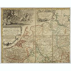
Nouvelle carte des postes d'Allemagne et des provinces limitrophes. . . Carte des postes d'Allemagne partie du nord est.
Upper left sheet of an important post route map of the Roman Empire with a dedication to Charles Anselme, prince de la Tour et Taxis (1733-1805). His section showing the ...
Date: Nuremberg, 1786
Selling price: ????
Please login to see price!
Sold in 2017
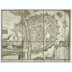
Plan de Wurtzburg résidence du prince évêque duc de Franconie.
Decorative plan of the fortified town of Wurzburg in Bavaria, adorned with a cartouche of 34 legends, topped with the coat of arms of the Prince-Bishop of Wurzburg and Du...
Date: Paris, 1786
Selling price: ????
Please login to see price!
Sold in 2019
Gouvernement D'Alsace avec les Grandes Routes.
An attractive and informative map of Alsace by French cartographer, Louis Brion de la Tour. It notes numerous towns, cities, rivers, forests, mountains and other topograp...
Date: Paris, 1786
Selling price: ????
Please login to see price!
Sold in 2018
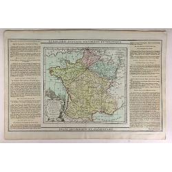
Carte Itineraire et Generaledes 18 Feuilles de l'Indicateur de France.
This is a striking 1786 Desnos and Brion map of France showing roads and the 18 administrative divisions. To the left and right of the map are paste downs of French text ...
Date: Paris, 1786
Selling price: ????
Please login to see price!
Sold in 2020
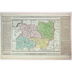
Carte des Departemens du Puy de Dome, du Cantel, du Rhone et Loire et de la Haute Loire.
This is a striking 1786 Desnos and Brion map of France showing four departments. To the left and right of the map are paste downs of French text with remarks and descript...
Date: Paris, 1786
Selling price: ????
Please login to see price!
Sold in 2018
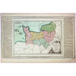
Carte des Departemensde la Manche, du Calvados de L'Orne, de L'Eure et de la Seine Inferieure.
This is a striking 1786 Desnos and Brion map of France showing five French departments. To the left and right of the map are paste downs of French text with remarks and d...
Date: Paris, 1786
Selling price: ????
Please login to see price!
Sold in 2017
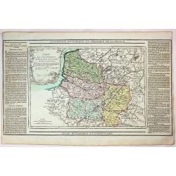
Carte des Deppartemens du Pas de Calais, de la Somme et de L'Oise dt de L'Aisne.
This is a striking 1786 Desnos and Brion map of three administrative divisions listed above. To the left and right of the map are paste downs of French text with remarks ...
Date: Paris, 1786
Selling price: ????
Please login to see price!
Sold in 2019
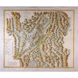
Carte de la Partie des Alpes Qui Avoisine le Mont Blanc.
A rare map featuring mountains in the Alps, mainly in Switzerland. This map is from the famous work by H. B. De Saussure "Voyages dans les Alpes" printed in Neu...
Date: Paris, 1786
Selling price: ????
Please login to see price!
Sold in 2017
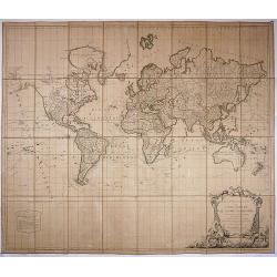
Mappe Monde ou carte générale du globe terrestre.
Extra large folding World map.
Date: Paris, 1786
Selling price: ????
Please login to see price!
Sold in 2017

Le Philosophe Democrite (Galerie du Palais Royal).
A fine copper engraving of Democritus,
Date: Paris, 1786
Selling price: ????
Please login to see price!
Sold in 2020
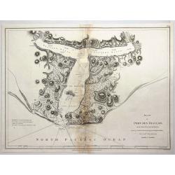
Plan of Port des Francais on the North West Coast of America in 58° 37' Latitude North and 139° 50 of Longitude West Discovered in July, 1786. . .
A fine copperplate chart of the 'Port des Francais' in Alaska. After reaching the northwest coast of America, at the height of Mount Saint-Elie, after one year of navigat...
Date: Paris, 1786
Selling price: ????
Please login to see price!
Sold in 2018
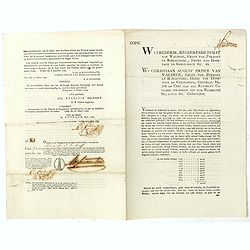
Bond and 9 coupons # 85 against a one year interest of 1000 Dutch Florins by Frederik ruler of Waldeck.
Bond for 10 years against one year interest of 1000 florins being 50 florins payable on January 1795 until 1804. With 9 pay-out coupons for one year interest of 1000 flor...
Date: The Hague / Amsterdam, 1786
Selling price: ????
Please login to see price!
Sold in 2020
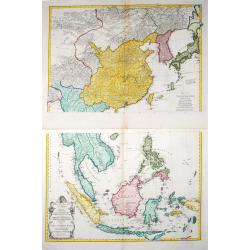
Zweiter Theil der Karte von Asien welcher China, einen Theil der Tartarei, Indien jenseits des Ganges, die Inseln Sumatra, Java . .
Two maps together depicting South East Asia / Zweiter Theil der Karte von Asien welcher China, einen Theil der Tartarei, Indien jenseits des Ganges, die Inseln Sumatra, ...
Date: Wien, 1786
Selling price: ????
Please login to see price!
Sold in 2021
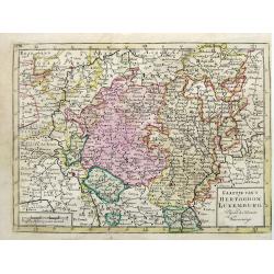
Kaartje van t Hertogdom Luxemburg, Volgens de Nieuwste Waarneminge.
An interesting map of Luxembourg after Isaac Tirion, engraved by Jacob Keizer and published by Elwe & Langeveld, in Amsterdam, 1786.
Date: Amsterdam, 1786
Selling price: ????
Please login to see price!
Sold in 2019
L'Amerique dressee pour l'etude de la geogrpahie. . .
A 1786 map of the North America and South America by French cartographer Louis Brion de la Tour. Showing the whole of North and South America with a number of interesting...
Date: Paris, 1786
Selling price: ????
Please login to see price!
Sold in 2021
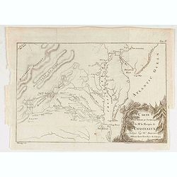
Carte Pour Servir Au Journal de Mr. Le Marquis de Chastellux Redigee par Mr. Dezoteux . . .
Chastellux's map of the Chesapeake region, including parts of Virginia, Maryland, Delaware & Pennsylvania. This map printed on thin paper shows Chastellux's route thr...
Date: Paris, 1786
Selling price: ????
Please login to see price!
Sold in 2021
Le Philosophe Democrite.
A copper engraving showing Democritus, sitting among ruins, the right hand placed on a globe, the left hand holding pair of compasses. Engraved by F.B. Lorieux after a pa...
Date: Paris, 1786
Selling price: ????
Please login to see price!
Sold in 2021
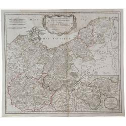
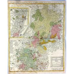
Partie Septentrionale de Cercle de la Haute Saxe.
A detailed map of northern Upper Saxony, in what is now Northeast Germany and Northwest Poland, by de Vaugondy. It includes the Duchy of Pomerania and Brandenburg, and ex...
Date: Paris, 1787
Selling price: ????
Please login to see price!
Sold in 2019
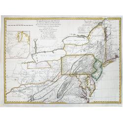
CARTE GENERALE DES ETATS de Virginie, Maryland, Delaware, Pensilvanie, Nouveau Jersey, New York, Connecticut et Isle de Rhodes. . .
A rare example of Louis Evans' important, first publication map of the Middle Colonies of 1755. Highlighted are Pensilvania and New Jersey. Engraved by Pierre Francois Ta...
Date: Paris, Tardieu, 1787
Selling price: ????
Please login to see price!
Sold in 2020
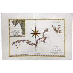
Carte de la Terre VAN DIEMEN.
A fine, engraved map of part of Tasmania focusing on the coastline surrounding Adventure Bay. Based on Captain James Cook's surveys. Engraved by Andre. Rigobert Bonne (17...
Date: Paris, 1787
Selling price: ????
Please login to see price!
Sold in 2020