Browse Listings
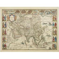
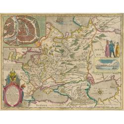
Asia noviter delineata.
With columns of figures on either side depicting the native manners of dress, and nine city plans and views at the top.Japan is shown accurately unusually with Korea as a...
Date: Amsterdam, 1663
Selling price: ????
Please login to see price!
Sold
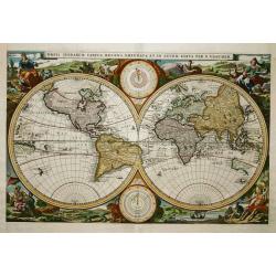
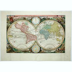
Orbis Terrarum Tabula Recens..
First state of this map from a Dutch Bible published by the renowned house of Elzevier. Superb double hemisphere world map, surrounded by engravings including allegorical...
Date: Amsterdam, 1663
Selling price: ????
Please login to see price!
Sold
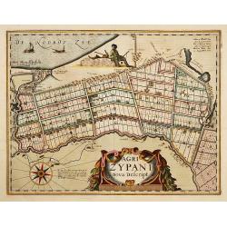
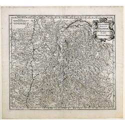
Agri Zypani Nova Descript.
Fine map of the region of the Zype. From a French text edition.The copperplate was originally by Petrus Kaerius, but was considerably revised by Joan Blaeu for his Atlas ...
Date: Amsterdam, 1663
Selling price: ????
Please login to see price!
Sold in 2019
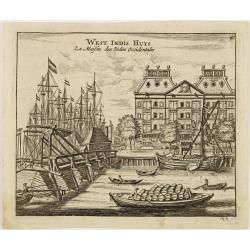
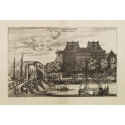
West Indis Huys - La Maison des Indes Occidentales.
A decorative print of the West Indian House , the headquarters of the W.I.C., a place for meeting, trading and storage of spices and ship equipment. The maps and charts w...
Date: Amsterdam, 1663
Selling price: ????
Please login to see price!
Sold in 2011
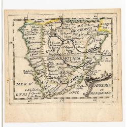
Cafrerie et Monomotapa.
Rare first state, 1663. While this map is generally well known from the 1676 edition, this first state, dated from the title page 1663 is rare. Table Bay isn\'t labeled,...
Date: Paris, 1663
Selling price: ????
Please login to see price!
Sold in 2008
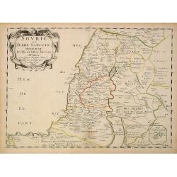
Sourie ou Terre Saincte moderne..
Decorative and detailed map of modern Palestine. Shows the political division under Turkish rule. Prepared by Philippe de La Rue. In lower right hand corner inset sketch ...
Date: Paris, 1663
Selling price: ????
Please login to see price!
Sold in 2013
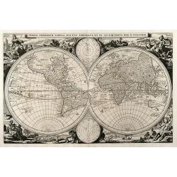
Orbis Terrarum Tabula Recens Emendata et in Lucem Edita per N. Visscher
Attractive worldmap in double hemisphere with two inset astronomical diagrams. From a dutch bible. Surround with allegorical representation of the continents. Visschers s...
Date: Amsterdam, 1663
Selling price: ????
Please login to see price!
Sold in 2010
Magazin de la Compagnie Occidentale. - Het West Indisch Huys.
A decorative print of the West Indian House , the headquarters of the W.I.C., a place for meeting, trading and storage of spices and ship equipment. The maps and charts w...
Date: Amsterdam, J. van Meurs, 1663
Selling price: ????
Please login to see price!
Sold in 2023

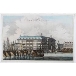
'T Oost Indisch Huys.
A decorative print of the East Indian House , the headquarters of the V.O.C., a place for meeting, trading and storage of spices and ship equipment.The maps and charts we...
Date: Amsterdam, J. van Meurs, 1663
Selling price: ????
Please login to see price!
Sold in 2015
Een ander gesicht van 'T LANDTS MAGAZYN.
A decorative print of the 'T Landts Magazyn, formerly the V.O.C. warehouse and arsenal for the Admiralty of Amsterdam, now-a-days the Scheepvaartmuseum (Maritime Museum)....
Date: Amsterdam, 1663
Selling price: ????
Please login to see price!
Sold in 2023
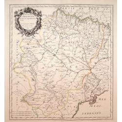
Royaume d'Arragon divisé, en sept dioeceses..
Map of Aragon, with original or early outline hand-color. Numerous place-names of counties, cities, towns, physical features. Prepared by N.Sanson.
Date: Paris, 1663
Selling price: ????
Please login to see price!
Sold in 2009
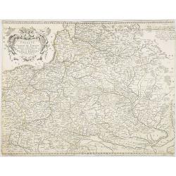
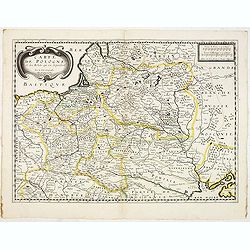
Etats de la couronne de Pologne ou sont les Royaume de Pologne, . . . De l'Ukanie &c.
A map of Poland, Dantzick (Gdansk) clearly marked on the coast and stretching down to the Black Sea. Numerous place-names of counties, cities, towns, physical features.
Date: Paris, 1663
Selling price: ????
Please login to see price!
Sold in 2009
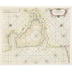
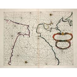
Pas-Caert van Archangel oste de rivier de Duina met.'t Nieuwe en't Oude diep.
Rare sea chart of th mouth of the Dwina River and the port town of Archangel, published by Jacob Theunisz (Lootsman). At first Jacob adopted his father Anthonie's name, b...
Date: Amsterdam, 1663
Selling price: ????
Please login to see price!
Sold in 2009
Tabula Russiae ex autographo, quod delineandum curavit Foedor filius Tzaris Boris desumta
Third state of a map by Hessel Gerritsz with an inset plan of Moscow and a view of Archangel. Without text on the back
Date: Amsterdam, c.1663
Selling price: ????
Please login to see price!
Sold in 2010
Le Gouvernement General Du Daufiné et des Pays circomuoisins ou sont La Savoye, La Bresse.
Map of central eastern France including Savoy and Bresse from Merian's atlas, "Topographia Galliae". Numerous cities and regions are noted including Lyon, Genev...
Date: Amsterdam, 1663
Selling price: ????
Please login to see price!
Sold in 2010
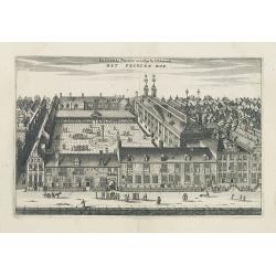
La Cour du Prince ou College de l'Admirauté. - HET PRINCEN HOF.
Decorative view of the "Prinsen Hof" in Amsterdam, now-a-days the "Hotel The Grand".Published in a French edition of "Historische Beschrijving de...
Date: Amsterdam, c.1663
Selling price: ????
Please login to see price!
Sold in 2020
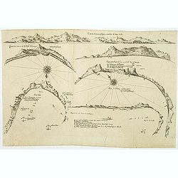
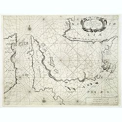
(6 coastal profiles)
A page with 6 coastal profiles of favorite anchor places and bays used by the Dutch and French vessels on their way to Asia : "Figure de la Terre de Saldagne",...
Date: Paris, 1663
Selling price: ????
Please login to see price!
Sold in 2011

Endhauptung deß Königs in Engelandt Ano 1649.
A fine copperplate engraving, unnamed from Theatrum Europaeum, Volume 6, printed by Daniel Fievet, Frankfurt 1663.King Charles I King of England, Scotland and Ireland who...
Date: Frankfurt,1663
Selling price: ????
Please login to see price!
Sold in 2011
Orbis Terrarum Tabula. . .
Magnificent double hemisphere Dutch Bible map. Surrounded by engravings of animals and four female allegorical representations of the continents. South America of 7inch, ...
Date: Amsterdam, 1663
Selling price: ????
Please login to see price!
Sold in 2013
Costa di Spagna del Riode Siviglia fino a Malaga et La Costa di Barbaria de Larache fino al Penon de Velez.
A sea-chart of the Strait of Gibraltar and the opposite coasts of Spain from the Rio Sevilla to Malaga and of North Africa. Embellished with a large title / distances car...
Date: Genoa, 1664
Selling price: ????
Please login to see price!
Sold
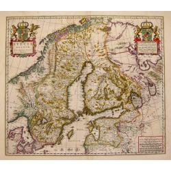
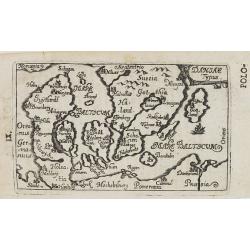
Sveciae Regnum.
An attractive map of the Kingdom of Sweden from the famous Blaeu company.
Date: Amsterdam, 1664
Selling price: ????
Please login to see price!
Sold
De Gelegenheyt van 't Paradys en 't Landt Canaan, mitsgaders de eerste bewoonde landen der Patriarchen? door Nicolaes Visscher.met Privilege vande Groot Mog: Heeren van Hollandt en West-Frieslandt voor 15 Jaaren. Broeck sculpsit.
Dutch so-called ' Staten' bibles, published between 1637 and c. 1760, contained 5 maps: The World, ' Paradise', The Perigrinations, The Promised Land Canaan, The Travels ...
Date: Amsterdam, 1664
Selling price: ????
Please login to see price!
Sold
Africa Descriptio.
Charming little map of Africa made by Gabriel Bucelin (1599-1681). Bucelin was a Swiss genealogist and an author of several books and a number of manuscript maps of Germa...
Date: Ulm, Johannes Görlin, 1658-1664
Selling price: ????
Please login to see price!
Sold in 2008
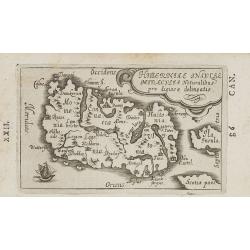
Hiberniae Insulae miraculis naturalibus pro digiosae delineatio.
Charming little map of Ireland made by Gabriel Bucelin (1599-1681). Bucelin was a Swiss genealogist and an author of several books and a number of manuscript maps of Germ...
Date: Ulm, Johannes Görlin, 1658-1664
Selling price: ????
Please login to see price!
Sold in 2008
Sabaudiae descriptio.
Charming little map of south east France, including Basel, Genève, Lyon, etc. made by Gabriel Bucelin (1599-1681). South to the top. Bucelin was a Swiss genealogist and ...
Date: Ulm, Johannes Görlin, 1658-1664
Selling price: ????
Please login to see price!
Sold in 2008
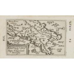
Neapolitani Regni Compendiosa Descriptio.
Charming little map of southern part of Italy, centered on Naples made by Gabriel Bucelin (1599-1681). Bucelin was a Swiss genealogist and an author of several books and ...
Date: Ulm, Johannes Görlin, 1658-1664
Selling price: ????
Please login to see price!
Sold in 2008
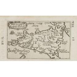
Siciliae. . .
Charming little map of Sicily made by Gabriel Bucelin (1599-1681). Bucelin was a Swiss genealogist and an author of several books and a number of manuscript maps of Germa...
Date: Ulm, Johannes Görlin, 1658-1664
Selling price: ????
Please login to see price!
Sold in 2008
![[ Malta ]](/uploads/cache/26001-250x250.jpg)
[ Malta ]
Charming little map of Malta made by Gabriel Bucelin (1599-1681). Bucelin was a Swiss genealogist and an author of several books and a number of manuscript maps of German...
Date: Ulm, Johannes Görlin, 1658-1664
Selling price: ????
Please login to see price!
Sold in 2008
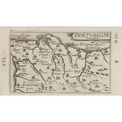
Portugalliae descriptio.
Charming little map of Portugal made by Gabriel Bucelin (1599-1681). Bucelin was a Swiss genealogist and an author of several books and a number of manuscript maps of Ger...
Date: Ulm, Johannes Görlin, 1658-1664
Selling price: ????
Please login to see price!
Sold in 2008
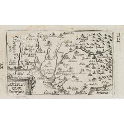
Andaluziae descriptio.
Charming little map of Andalusia made by Gabriel Bucelin (1599-1681). Bucelin was a Swiss genealogist and an author of several books and a number of manuscript maps of Ge...
Date: Ulm, Johannes Görlin, 1658-1664
Selling price: ????
Please login to see price!
Sold in 2008
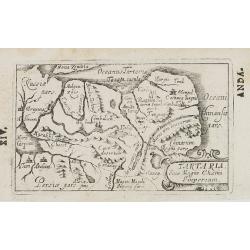
Tartaria Sive Magni Chami Imperium.
Charming little map of Tartary made by Gabriel Bucelin (1599-1681). Bucelin was a Swiss genealogist and an author of several books and a number of manuscript maps of Germ...
Date: Ulm, Johannes Görlin, 1658-1664
Selling price: ????
Please login to see price!
Sold in 2008
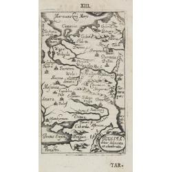
Russia obiter delineata et adunibrata.
Charming little map of Russia made by Gabriel Bucelin (1599-1681). Bucelin was a Swiss genealogist and an author of several books and a number of manuscript maps of Germa...
Date: Ulm, Johannes Görlin, 1658-1664
Selling price: ????
Please login to see price!
Sold in 2008
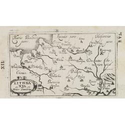
Lithuania obiter adumbrata.
Charming little map of Lithuania made by Gabriel Bucelin (1599-1681). Bucelin was a Swiss genealogist and an author of several books and a number of manuscript maps of Ge...
Date: Ulm, Johannes Görlin, 1658-1664
Selling price: ????
Please login to see price!
Sold in 2008
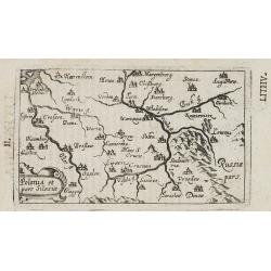
Polonia et pars Silesiae.
Charming little map of Poland made by Gabriel Bucelin (1599-1681). Bucelin was a Swiss genealogist and an author of several books and a number of manuscript maps of Germa...
Date: Ulm, Johannes Görlin, 1658-1664
Selling price: ????
Please login to see price!
Sold in 2008
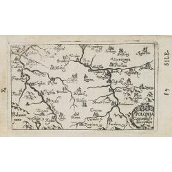
Polonia. . .
Charming little map of Poland made by Gabriel Bucelin (1599-1681). Bucelin was a Swiss genealogist and an author of several books and a number of manuscript maps of Germa...
Date: Ulm, Johannes Görlin, 1658-1664
Selling price: ????
Please login to see price!
Sold in 2008
Daniae Typus.
Charming little map of Denmark made by Gabriel Bucelin (1599-1681). Bucelin was a Swiss genealogist and an author of several books and a number of manuscript maps of Germ...
Date: Ulm, Johannes Görlin, 1658-1664
Selling price: ????
Please login to see price!
Sold in 2008

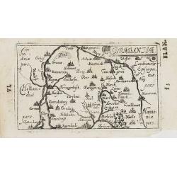
Hollandiae superficialis descriptio.
Charming little map of Holland made by Gabriel Bucelin (1599-1681). Bucelin was a Swiss genealogist and an author of several books and a number of manuscript maps of Germ...
Date: Ulm, Johannes Görlin, 1658-1664
Selling price: ????
Please login to see price!
Sold in 2008
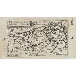
Flandriae. . .
Charming little map of Belgium made by Gabriel Bucelin (1599-1681). Bucelin was a Swiss genealogist and an author of several books and a number of manuscript maps of Germ...
Date: Ulm, Johannes Görlin, 1658-1664
Selling price: ????
Please login to see price!
Sold in 2008
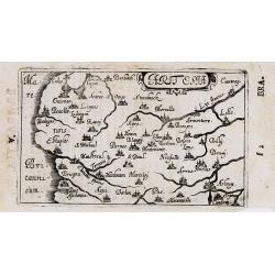
Brabantiae.
Charming little map of Brabant made by Gabriel Bucelin (1599-1681). Bucelin was a Swiss genealogist and an author of several books and a number of manuscript maps of Germ...
Date: Ulm, Johannes Görlin, 1658-1664
Selling price: ????
Please login to see price!
Sold in 2008
Artesia. . .
Charming little map of French province of Artois made by Gabriel Bucelin (1599-1681). Bucelin was a Swiss genealogist and an author of several books and a number of man...
Date: Ulm, Johannes Görlin, 1658-1664
Selling price: ????
Please login to see price!
Sold in 2008
Persarum. . .
Charming little map of Persia made by Gabriel Bucelin (1599-1681). Bucelin was a Swiss genealogist and an author of several books and a number of manuscript maps of Germa...
Date: Ulm, Johannes Görlin, 1658-1664
Selling price: ????
Please login to see price!
Sold in 2008
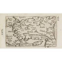
Natolia. . .
Charming little map of Turkey, with an oversized Cyprus, made by Gabriel Bucelin (1599-1681). Bucelin was a Swiss genealogist and an author of several books and a number ...
Date: Ulm, Johannes Görlin, 1658-1664
Selling price: ????
Please login to see price!
Sold in 2008
Turci Impery adumbratio.
Charming little map of Ottoman Empire, made by Gabriel Bucelin (1599-1681). Bucelin was a Swiss genealogist and an author of several books and a number of manuscript maps...
Date: Ulm, Johannes Görlin, 1658-1664
Selling price: ????
Please login to see price!
Sold in 2008
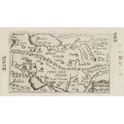
Asiae Superficialis descriptio.
Charming little map of Asia made by Gabriel Bucelin (1599-1681). Bucelin was a Swiss genealogist and an author of several books and a number of manuscript maps of Germany...
Date: Ulm, Johannes Görlin, 1658-1664
Selling price: ????
Please login to see price!
Sold in 2008
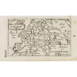
Europa.
Charming little map of Europe made by Gabriel Bucelin (1599-1681). Bucelin was a Swiss genealogist and an author of several books and a number of manuscript maps of Germa...
Date: Ulm, Johannes Görlin, 1658-1664
Selling price: ????
Please login to see price!
Sold in 2008

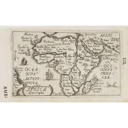
Americae nova Descriptio.
Charming little map of the North and South American continents, made by Gabriel Bucelin (1599-1681). In lower left corner part of the large southern continent "Terra...
Date: Ulm, Johannes Görlin, 1658-1664
Selling price: ????
Please login to see price!
Sold in 2008
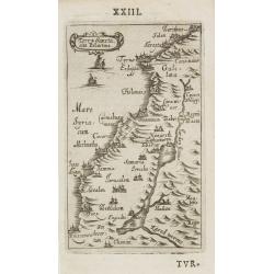
Terra Sancta sine Palestina.
Charming little map of the Holy Land made by Gabriel Bucelin (1599-1681). Bucelin was a Swiss genealogist and an author of several books and a number of manuscript maps o...
Date: Ulm, Johannes Görlin, 1658-1664
Selling price: ????
Please login to see price!
Sold in 2008
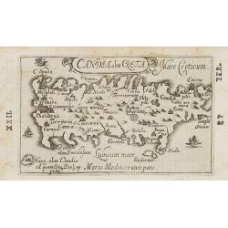
Candia olim Creta. . .
Charming little map of Crete made by Gabriel Bucelin (1599-1681). Bucelin was a Swiss genealogist and an author of several books and a number of manuscript maps of German...
Date: Ulm, Johannes Görlin, 1658-1664
Selling price: ????
Please login to see price!
Sold in 2008
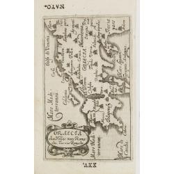
Graecia olim Hellas nunc Rome=ehi, Turris Romechi.
Charming little map of Greece, made by Gabriel Bucelin (1599-1681). Bucelin was a Swiss genealogist and an author of several books and a number of manuscript maps of Germ...
Date: Ulm, Johannes Görlin, 1658-1664
Selling price: ????
Please login to see price!
Sold in 2008
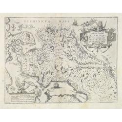
La Gran Penisola DELLA SCANDIA Madre d innumerabili Essercili e Regali Famiglie pertutta l'Europa diffuse.
Scarce map of Scandinavia with decorative cartouche and scale of miles, north orientated to the right. Engraved by Antonio de Piene for "Emmanuele Tesauro's Del Regn...
Date: Turin, 1664
Selling price: ????
Please login to see price!
Sold
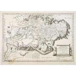
Principauté de Transilvanie tirée de W. Lazius, de I. Sambucus, et de G. Mercator. . .
Map of Hungary, based on map of Wolfgang Lazius. Belgrade in lower left corner. Numerous place-names of counties, cities, towns, physical features.
Date: Paris, 1664
Selling price: ????
Please login to see price!
Sold in 2010
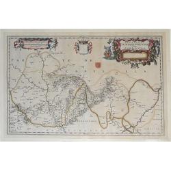
Episcopatus Turiassonensis Vulgo Tarracona. . .
Beautiful map of the Catalonia and Aragon region of northeastern Spain by Joan Blaeu. Shows the cities of Daroca, Calatajud, Borja, and Tarragona, along with the mountain...
Date: Amsterdam, 1664
Selling price: ????
Please login to see price!
Sold in 2010
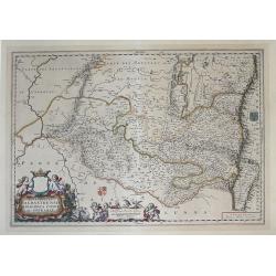
Episcopatus Balbastrensis, Ribagorca Comit. Et Sobrarbe. . .
Beautiful map of the Aragon and Catalonia regions of northeastern Spain, along the southern French border by Joan Blaeu. Shows the cities of Huesca and Lerida, along with...
Date: Amsterdam, 1664
Selling price: ????
Please login to see price!
Sold in 2010
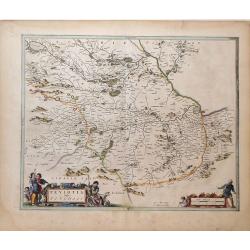
Teviotia Vulgo Tivedail
Beautiful map of Teviotdale, a region of Southeast Scotland, by Joan Blaeu. Shows the cities Selkirk and Kelso, along with the mountains, rivers and forests of the region...
Date: Amsterdam, 1664
Selling price: ????
Please login to see price!
Sold in 2010
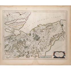
Moravia Scotiae provincial. . .
Beautiful map of Moray, a region of Northeast Scotland, by Joan Blaeu. Shows the towns of Inverness, Forres and Elgin, along with the mountains, rivers and forests of the...
Date: Amsterdam, 1664
Selling price: ????
Please login to see price!
Sold in 2010
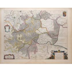
Regiones Inundata Infinibus comitatus Norfolcia, Suffolcia, Cantabrigia, Huntingtonia, Northhamtonia, et Lincolnia
Beautiful map of the East Anglia region of England, showing the counties of Norfolk, Suffolk, Cambridge, Huntington, Northampton and Lincoln, along with the mountains, ri...
Date: Amsterdam, 1664
Selling price: ????
Please login to see price!
Sold in 2010
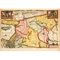
Tetrachia Ducatus Gelriae Rurmundensis.
East to the top. Covering northern part of Limburg, including the towns of Gennip, Geldern, Venlo, Roermond, Weert. In top coats of arms of 8 cities and the province. Rar...
Date: Amsterdam, 1664
Selling price: ????
Please login to see price!
Sold in 2018
Carta maritima del Golfo di Smirne com anche l'Isola Scio e come fra essa, e la terra ferma di Calaberno si possa veleggiar
Rare chart showing the Gulf of Smyrna (Izmir) and the east coast of the Greek island of Chios. From "Specchio del Mare", ("Mirror of the Sea"). Levant...
Date: Genoa, 1664
Selling price: ????
Please login to see price!
Sold in 2011
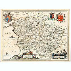
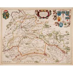
Montgomeria comitatus et comitatus Mervinia.
A beautifully engraved and presented map of the mid Welsh counties of Merionethshire and Montgomeryshire, as published in the Dutch edition of the Atlas Major.In addition...
Date: Amsterdam, ca 1664
Selling price: ????
Please login to see price!
Sold in 2020

Leogus et Haraia, insulae ex Aebudarum numero . . .
This is an uncommon and lovely map of Lewis and Harris in the Western Isles. The map is oriented with west at top and is richly embellished with decorative cartouches sur...
Date: Amsterdam, 1664
Selling price: ????
Please login to see price!
Sold in 2020
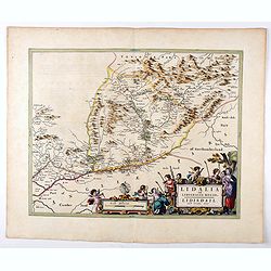
Lidalia el Lidisdalia Regio.
The region that this map covers is north-western England and the Scotland border. Solwat Forth is located in the lower left corner. The Hermitage Castle, built in 1244, i...
Date: Amsterdam, 1664
Selling price: ????
Please login to see price!
Sold in 2021
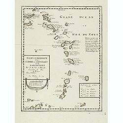
Isles d'Amerique dites Caribes ou Cannibales et de Barlovento. . .
Uncommon map of the Lesser Antilles from the Virgin Islands to Margarita Island off the coast of Venezuela. Navigational notes and a lettered key to European possessions ...
Date: Paris, 1664
Selling price: ????
Please login to see price!
Sold
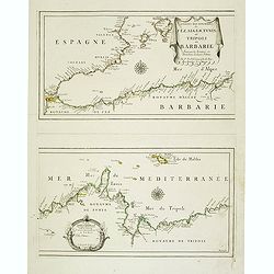
Les Costes Des Royaumes de Fez, Alger, Tunis et Tripoli en Barbarie suivant les Routiers et Portolans de divers Pilotes . . .
Two Uncommon maps on one sheet of the Mediterranean Sea with the coast of North Africa with the kingdoms of Tunis and Tripoli. Including the southeastern coast of Spain w...
Date: Paris, 1664
Selling price: ????
Please login to see price!
Sold in 2020
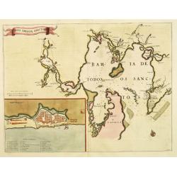
Sinus Omnium Sanctoru. Bahia de Todos os Sanctos.
First Atlas Major issue: originally issued by Blaeu in Casper van Baarle's 'Rerum per Octennium in Brasilia' (1647) dedicated to the former Governor of the Dutch colony, ...
Date: Amsterdam, 1664
Selling price: ????
Please login to see price!
Sold in 2012
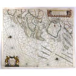
Nieuwe Pas Caert van de Witte Zee begrypende de custen van Laplandt, van Warsiga tot aen Kandalox, en de cust van Corelia tot aen de Riviere Dvina. . .
Beautifuland scarce chart from Nieuw Groot Stuermans Zee-Spiegel, Inhoudende De Zee-kusten van de Noorsche, Oostersche, en Westersche Schipvaert. Showing the White Sea.
Date: Amsterdam, 1664
Selling price: ????
Please login to see price!
Sold in 2014
![[No title] Hollandia Nova detecta 1644.](/uploads/cache/36150-250x250.jpg)
[No title] Hollandia Nova detecta 1644.
EXTREMELY RARE FIRST EDITION of Thevenot's map of Australia which is the first published large-scale map of Australia and the first French map to record Tasman's 1642-42 ...
Date: Paris, 1664
Selling price: ????
Please login to see price!
Sold in 2015
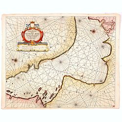
De Cust Van Zeelandt ....
A striking and highly detailed, beautiful copper engraved nautical chart of Zeeland, the westernmost province of Netherlands. Two beautiful compass roses radiating rhumb ...
Date: Amsterdam, 1664
Selling price: ????
Please login to see price!
Sold in 2016
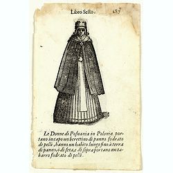
Libro Sesto - Le Donne di Posnania in Polonia . . . (double sided page)
On each side an wood cut engraving of an Polish lady. After Cesare Vecellio (Italian, Pieve di Cadore 1521–1601 Venice). Double sided portrait of Polish women, wood blo...
Date: Venice, Francesco Bodio, 1664
Selling price: ????
Please login to see price!
Sold in 2018
Lorn Wt the Yles and provinces bordering there-upon.
This is the lovely Blaeu map of Lorn, published in Amsterdam during the second half of the seventeenth century. The map is oriented to the west. Lorn is an area situated ...
Date: Amsterdam, ca 1664
Selling price: ????
Please login to see price!
Sold in 2019
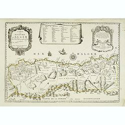
Carte du Royaume d'Alger . . .
Uncommon map of the Algerian coast, with fine title and scale cartouches in the top.
Date: Paris, 1665
Selling price: ????
Please login to see price!
Sold
l'Ordinum vulgo Staten Eyland.
Important map of Vaygach Island (Staten Eyland), decorated by a small scene of a polar bear attacking two Dutch explorers.
Date: Amsterdam, 1665
Selling price: ????
Please login to see price!
Sold in 2012
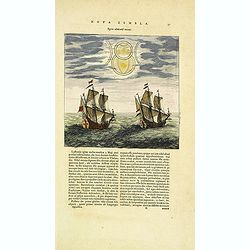
Figura admirandi meteori.
Two Dutch ships observe a "marvelous meteor" during their voyage. The witnesses said "the object moved slowly in the sky above them and seemed to be made o...
Date: Amsterdam, 1665
Selling price: ????
Please login to see price!
Sold in 2012
Carte de Pologne et des Estats qui en dépendent Par du Val. . .
Uncommon map of Poland, Lithuania, Latvia, Estonia and a portion of Russia, extending from the Oder to the Black Sea and Smolensk, centered on Wilma. Includes all of Pola...
Date: Paris, ca 1665
Selling price: ????
Please login to see price!
Sold in 2012
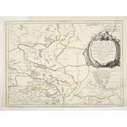
Partie de Lithuanie ou sonts les Palatinats de Minsk et Mseislaw.
Scarce and fine map of Lithuania. This edition carries the date 1666 and the publishers address "A Paris, chez l'Autheur". Engraved by A. Peyrounin . Nicolas Sa...
Date: Paris, 1665
Selling price: ????
Please login to see price!
Sold in 2013
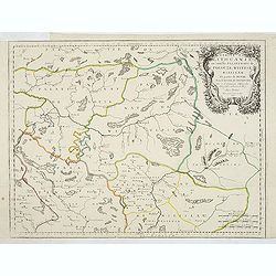
Partie de Lithuanie où sont les palatinats de Poloczk, Witepsk, Mseislaw, et partie de Minsk avec le duché de Smolensko.
Scarce and fine map of Belarus, including Smolensko in Russia and the region northeast of Minsk. This edition carries the date 1665 and the publishers address "A Par...
Date: Paris, 1665
Selling price: ????
Please login to see price!
Sold in 2013
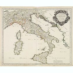
L'Italie et les Isles circomvoisines Sicile, Sardagne. . .
Map of Italy including the islands of Sicily, Sardinia and Corsica, with original or early outline hand-color. Numerous place-names of counties, cities, towns, physical f...
Date: Paris, 1665
Selling price: ????
Please login to see price!
Sold in 2016

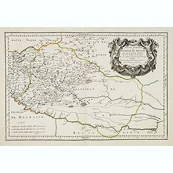
Basse Volhynie ou palatinat de Kiow, tiré entièrement de la grande Ukraine du Sieur le Vasseur de Beauplan / par le Sr. . .
Scarce and fine map after Guillaume Le Vasseur de Beauplan (c. 1600 — December 6 1673), who was a French cartographer, engineer and architect. Beauplan served as artill...
Date: Paris, 1665
Selling price: ????
Please login to see price!
Sold in 2013
Basse podolie, Palatinat de Braclaw tiré de la grande Ukraine du Sieur le Vasseur de Beauplan / par le Sr. . .
Scarce and fine map of Ukraine after Guillaume Le Vasseur de Beauplan (c. 1600 — December 6 1673), who was a French cartographer, engineer and architect. Beauplan serve...
Date: Paris, 1665
Selling price: ????
Please login to see price!
Sold in 2013
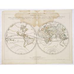
Orbis Vetus, et Orbis Veteris, utraque Continens, Terrarumq Tractus Arcticus, et Antarcticus ex Platone, Theopompo sive Aehano, Manilio . . . MDCLVII
Nicolas Sanson's map of the ancient world was also issued separately in 1657before being incorporated in the first formal edition of Sanson's world atlas in 1658. The map...
Date: Paris, 1665
Selling price: ????
Please login to see price!
Sold in 2013
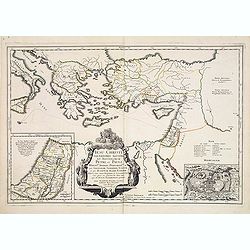
Jesu Christi Salvatoris Nostri et Apostolorum Petri et Pauli Mansiones, Itinera Pergrinationes. . .
Showing eastern part of the Mediterranean, including Cyprus, Italy. Lower right hand corner inset plan of Jerusalem. Lower left map of Palestine.
Date: Paris, 1665
Selling price: ????
Please login to see price!
Sold in 2015