Browse Listings
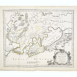
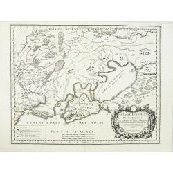
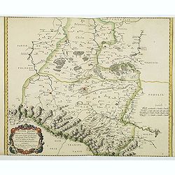
Cimmeria quae postea Scythia Europaea seu Parua Scythia / ex conatibus geographicis Gulielmi Sanson. . .
Ancient map of the region north of the Black Sea. Showing mountains, forests and cities and locates historical regions. The title cartouche includes a small vignette feat...
Date: Paris, 1665
Selling price: ????
Please login to see price!
Sold in 2013
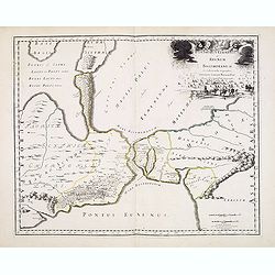
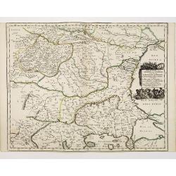
Bosphorus Cimmerius et regnum bosphoranum / ex collectionibus. . .
Historical map illustrating the Kerch Strait between the Sea of Azov in southern Ukraine and the Black Sea and not the Bosporus as indicated by the title. The map is fill...
Date: Paris, 1665
Selling price: ????
Please login to see price!
Sold in 2013
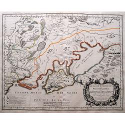
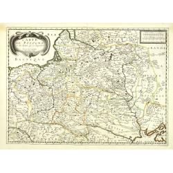
Tartarie Europeenne ou Petite Tartari ou sont Les Tartares, Du Crim, ou de Perecop; De Nogais, D'Oczacow, et de Budziak...
Detailed map of Ukraine, the Crimea, Sea of Azov, and the northern part of the Black Sea. Includes the cities of Kiev, Smolensk, Ryazan, Belgorod, and many more. With i...
Date: Paris, 1665
Selling price: ????
Please login to see price!
Sold in 2014
![[Two Bible Leaves.]](/uploads/cache/94020-250x250.jpg)
[Two Bible Leaves.]
Two hand colored copper engravings by Matthaus Merian, the younger,the Swiss engraver from the De Bry family. They are from an unidentified German bible from 1665.
Date: Frankfürt, 1665
Selling price: ????
Please login to see price!
Sold in 2014
![Typus Montis Aetnae... [Mt. Aetna]](/uploads/cache/94034-250x250.jpg)
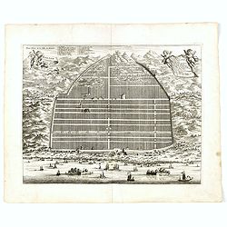
Typus Montis Aetnae... [Mt. Aetna]
Kircher witnessed the eruption of Etna and Stromboli, and had himself lowered into the active crater at Vesuvius. These adventures ignited an abiding interest in geograph...
Date: Amsterdam, Joannes Jansson and Eizeus Weyerstraten, 1665
Selling price: ????
Please login to see price!
Sold in 2014
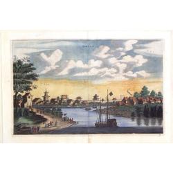
Xantsui.
Beautiful city view in China by John Nieuhoff, an explorer and Dutch diplomat. Published by Pieter van der Aa in his "L'AMBASSADE DE LA COMPAGNIE ORIENTALE" in ...
Date: Leiden, 1665
Selling price: ????
Please login to see price!
Sold in 2019
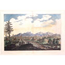
Single, China.
Beautiful city view in China by John Nieuhoff, an explorer and Dutch diplomat. Original copper engraving was published by Pieter van der Aa in his "L'AMBASSADE DE LA...
Date: Leiden, 1665
Selling price: ????
Please login to see price!
Sold in 2017
Peking, China.
Beautiful city view in China by John Nieuhoff, an explorer and Dutch diplomat. Original copper engraving was published by Pieter van der Aa in his "L'AMBASSADE DE LA...
Date: Leiden, 1665
Selling price: ????
Please login to see price!
Sold in 2016
![Gründlicher Bericht Von dem biß in den Februar. dieses 1665sten Jahrs am Himmel gestandenen importirlichen Cometen . . . [together with] Appendix vom neuen Cometen und dessen vermuthlichen Bedeutung. . .](/uploads/cache/34120-250x250.jpg)
Gründlicher Bericht Von dem biß in den Februar. dieses 1665sten Jahrs am Himmel gestandenen importirlichen Cometen . . . [together with] Appendix vom neuen Cometen und dessen vermuthlichen Bedeutung. . .
Christophori Nottnagels Mathem. Prof. Publ. zu Wittenberg/ Gründlicher Bericht/ Von dem biß in den Februar. dieses 1665sten Jahrs/ am Himmel gestandenen importirlichen ...
Date: Wittenberg, Henckel, 1665
Selling price: ????
Please login to see price!
Sold in 2015
Kanton in platte grondt / Plate forme de la ville de Kanton.
Bird’s-eye view of the city of Canton.From Olfert Dapper mission to China, 1662-1663. Printed by Jacob van Meurs, title of the book: Gedenckwaerdig bedrijf der Nederlan...
Date: Amsterdam, 1665
Selling price: ????
Please login to see price!
Sold in 2015
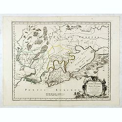
Cimmeria quae postea Scythia Europaea seu Parua Scythia / ex conatibus geographicis Gulielmi Sanson. . .
Ancient map of the region north of the Black Sea. Showing mountains, forests and cities and locates historical regions. The title cartouche includes a small vignette feat...
Date: Paris, 1665
Selling price: ????
Please login to see price!
Sold in 2017
Kanton in platte grondt / Plate forme de la ville de Kanton.
Bird’s-eye view of the city of Canton.From Olfert Dapper mission to China, 1662-1663. Printed by Jacob van Meurs, title of the book: Gedenckwaerdig bedrijf der Nederlan...
Date: Amsterdam, 1665
Selling price: ????
Please login to see price!
Sold in 2019
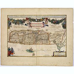
Situs Terrae Promissionis. . .
A truly superb, decorative map with north oriented to the left. It is finely engraved with numerous biblical scenes including the Exodus, the wandering of the Children of...
Date: Amsterdam, 1665
Selling price: ????
Please login to see price!
Sold in 2017
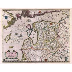
Livonia vulgo Lyefland.
Antique map of the Baltic States Estonia and Latvia.
Date: Amsterdam, 1662 - 1665
Selling price: ????
Please login to see price!
Sold in 2017
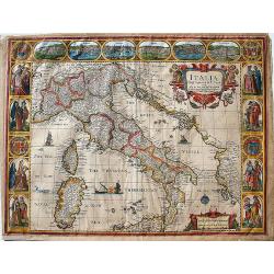
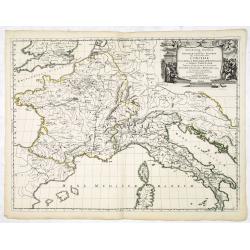
Italia Newly Augmented by J. Speede.
John Speed's map of Italy, from his famous atlas "Prospect of the Most Famous Parts of the World".This map is regarded as the most beautiful and decorative map ...
Date: London, Basset, 1662-1665
Selling price: ????
Please login to see price!
Sold in 2017
![[Set of 4 maps] Meklenburg Ducatus / Circulus Westphalicus / Thuringia Landgraviatus / Oldenburg Comitatus.](/uploads/cache/40529-250x250.jpg)
[Set of 4 maps] Meklenburg Ducatus / Circulus Westphalicus / Thuringia Landgraviatus / Oldenburg Comitatus.
The first map is of Mecklenburg, and it is a finely engraved map with a very decorative title cartouche adorned with a chain of fruits. A ship is sailing on the Baltic ne...
Date: Amsterdam, 1635 - 1665
Selling price: ????
Please login to see price!
Sold in 2017
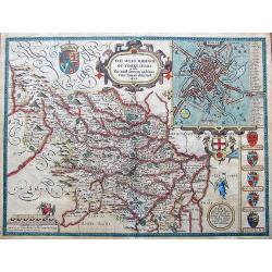
The West Ridinge of Yorkeshyre with The most famous and fayre Citie Yorke described 1610.
Speed's important and decorative map of Yorkshire. The county is shown with many place names, hundreds, rivers, hills, forests, and much more. It features several coats o...
Date: London, ca. 1665
Selling price: ????
Please login to see price!
Sold in 2017
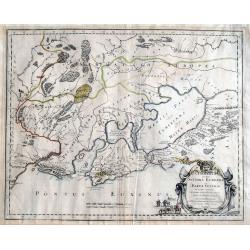
Cimmeria quae Postea Scythia Europaea Seu Parua Scythia. . .
A great map of Crimea, with parts of the Ukraine, and Russia. The map shows mountains, forests, regions and cities with their historical names. A strap work title cartouc...
Date: Paris, 1665
Selling price: ????
Please login to see price!
Sold in 2020
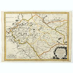
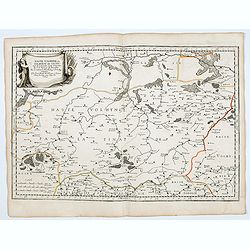
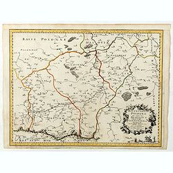
Basse ou Grande Pologne ou sont les Palatinats de Posna, Calisch, Strad, Lencici, Rava, Brest et Inowlocz.
Regional map of Poland, including Breslaw, Poznan, etc. Engraved by J.Sommer.Nicolas Sanson was to bring about the rise of French cartography, although the fierce competi...
Date: Paris, 1665
Selling price: ????
Please login to see price!
Sold in 2019
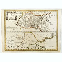
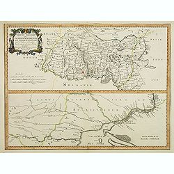
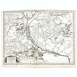
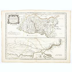
Haute Podolie ou palatinat de Kamieniec tirée entierement de la Gr. Vkraine . . .
Two maps on one sheet covering parts of Romania and Ukrania. Prepared by Guillaume Le Vasseur de Beauplan (1600-1685) , who was a French cartographer, engineer and archit...
Date: Paris, 1665
Selling price: ????
Please login to see price!
Sold in 2019
Basse Podolie, Palatinat de Braclaw tiré de la grande Ukraine du Sieur le Vasseur de Beauplan / par le Sr. . .
Scarce and fine map of Ukraine after Guillaume Le Vasseur de Beauplan (c. 1600 — December 6 1673), who was a French cartographer, engineer and architect. Beauplan serve...
Date: Paris, 1665
Selling price: ????
Please login to see price!
Sold in 2020
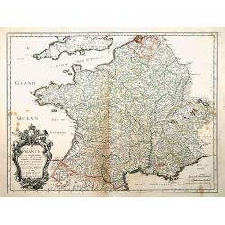
Le Royaume de France, et ses acquisitions..
"Fine map of France. The cartouche presents the address of Pierre Mariette; rue St.Jacques a L'Esperance"". Nicolas Sanson was to bring about the rise of F...
Date: Paris 1665
Selling price: ????
Please login to see price!
Sold
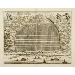
Kanton in platte grondt / Plate forme de la ville de Kanton.
Bird?s-eye view of the city of Canton.From Olfert Dapper mission to China, 1662-1663. Printed by Jacob van Meurs, title of the book: Gedenckwaerdig bedrijf der Nederlands...
Date: Amsterdam 1665
Selling price: ????
Please login to see price!
Sold
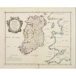
Irlande Royaume divisé en ses quatre provinces..
Covering Ireland. Nicolas Sanson was to bring about the rise of French cartography, although the fierce competition of the Dutch would last until the end of the century. ...
Date: Paris 1665
Selling price: ????
Please login to see price!
Sold
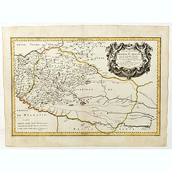
Tartarie Europeenne ou Petite Tartari où sont Les Tartares, Du Crim, ou de Perecop, De Nogais, D'Oczacow, et de Budziak . . .1665
Detailed map of Ukraine, the Crimea and the northern part of the Caspian Sea. Numerous place-names of counties, cities, towns, physical features.
Date: Paris, 1665
Selling price: ????
Please login to see price!
Sold in 2011
Cours du Danube, depuis Belgrade.. Transilvanie. . .
Eastern part of the River Danube, including parts of Macedonia, Bulgaria, Romania, Yugoslavia. Belgrade to the west. With original or early outline hand-color. Numerous p...
Date: Paris, 1665
Selling price: ????
Please login to see price!
Sold in 2010
Carte de Pologne et des Estats qui en dépendent Par du Val. . .
Uncommon map of Poland, Lithuania, Latvia, Estonia and a portion of Russia, extending from the Oder to the Black Sea and Smolensk, centered on Wilma. Includes all of Pola...
Date: Paris, ca 1665
Selling price: ????
Please login to see price!
Sold in 2010
Haute Podolie ou Palatinat de Kamieniec tirée entièrement de la Gr. Ukranie. . .
Two maps on one sheet covering parts of Romania. Prepared by Guillaume Le Vasseur de Beauplan (1600-1685).
Date: Paris, 1665
Selling price: ????
Please login to see price!
Sold in 2011
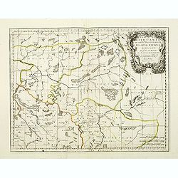
RUSSIE NOIRE. divisée en ses Palatinats. &c. tirée pour la plus grande partie de la grande Carte de l'Ukraine, du Sr. le Va??eur de Beauplan. Par le Sr SANSON d'Abbeville Geogrr ordre du Roy.
First state. Map of the Ukraine and centered on Lvov (Lemberg). The map was based on the map of Ukraine by Beauplan and Radziwill's map of Lithuania.
Date: Paris, 1665
Selling price: ????
Please login to see price!
Sold in 2011
Partie de Lithuanie ou sont les Palatinats de Poloczk, Witepsk...
Fine map of Lithuania. This edition carries the date 1665 and the publishers address "A Paris, chez l'Autheur". Nicolas Sanson was to bring about the rise of Fr...
Date: Paris, 1665
Selling price: ????
Please login to see price!
Sold in 2011
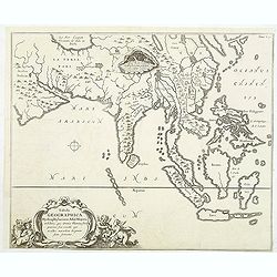
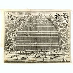
Tabula Geographica Hydrophylacium Asiae Majoris. . .
The Jesuit scholar Athanasius Kircher was one of the first compilers of semi-scientific knowledge about the physical features of the world. This very unusual map depicts ...
Date: Amsterdam, 1665
Selling price: ????
Please login to see price!
Sold in 2011
![RUSSIE NOIRE divisee en ses Palatinats &c. [Lviv]](/uploads/cache/83216-250x250.jpg)
RUSSIE NOIRE divisee en ses Palatinats &c. [Lviv]
A rare map of the so-called 'Black Russia' region in south-western Ukraine. With a cartouche and with mountains, forests and many names of cities, rivers and villages dep...
Date: Paris, 1665
Selling price: ????
Please login to see price!
Sold in 2020
Basse Volhynie ou palatinat de Kiow, tiré entièrement de la grande Ukraine du Sieur le Vasseur de Beauplan / par le Sr. . .
Scarce and fine map after Guillaume Le Vasseur de Beauplan (c. 1600 — December 6 1673), who was a French cartographer, engineer and architect. Beauplan served as artill...
Date: Paris, 1665
Selling price: ????
Please login to see price!
Sold in 2020
Haute Volhynie ou palatinat de Lusuc, tiré entièrement de la grande Ukraine du Sieur le Vasseur de Beauplan . . .
Scarce and fine map after Guillaume Le Vasseur de Beauplan (c. 1600 — December 6 1673), who was a French cartographer, engineer and architect. Beauplan served as artill...
Date: Paris, 1665
Selling price: ????
Please login to see price!
Sold in 2020
Haute Podolie ou palatinat de Kamieniec, tirée entièrement de la Gr. Ukraine du Sr Le Vaaseur de Beauplan / par le Sr Sanson. . .
Two maps on one sheet covering parts of Romania and Ukraine. Prepared by Guillaume Le Vasseur de Beauplan (1600-1685) , who was a French cartographer, engineer and archit...
Date: Paris, 1665
Selling price: ????
Please login to see price!
Sold in 2020
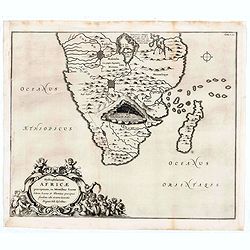
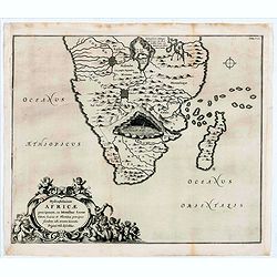
Hydrophylacium Africae precipuum, in montibus lunae situm.
Rare and Interesting map showing the sources of the Nile in a cavern beneath the Mountains of the Moon. From Kircher's "Mundus Subterranaeus". Top right Tomus I...
Date: Amsterdam, 1665
Selling price: ????
Please login to see price!
Sold in 2020
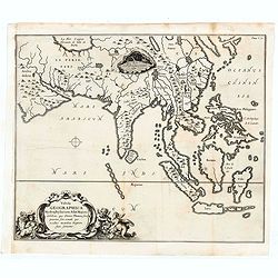
Tabula Geographica Hydrophylacium Asiae Majoris exhibens, quo Omnia Flumina sive proxime sive remote per occultos maeandros Originem suam Sortiuntur.
Rare and Interesting map showing Asia from Arabia in the west until China, Japan, Korea and Philippines with Indonesia. From Kircher's "Mundus Subterranaeus". T...
Date: Amsterdam, 1665
Selling price: ????
Please login to see price!
Sold in 2020
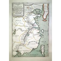
Carte du Voyage des Ambassadeurs de la Compagnie Orientale des Provinces Unies, vers le Tartare Empereur de la Chine. . .
A scarce map of China illustrating the Dutch expedition to China led by Johan Nieuhof in 1655-57.
Date: Paris, ca. 1665
Selling price: ????
Please login to see price!
Sold in 2020
Basse Podolie, Palatinat de Braclaw tiré de la grande Ukraine du Sieur le Vasseur de Beauplan / par le Sr. . .
Scarce and fine map of Ukraine after Guillaume Le Vasseur de Beauplan (c. 1600 — December 6 1673), who was a French cartographer, engineer and architect. Beauplan serve...
Date: Paris, 1665
Selling price: ????
Please login to see price!
Sold in 2025
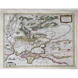
Taurica Chersonesus Nostra aetate Przecopsca et Gazara dicitur.
A map showing the area between the northern coast of the Black Sea, the present day Ukraine and part of Russia, with the Crimean including the mouth of the Danube River a...
Date: Amsterdam, 1662-1665
Selling price: ????
Please login to see price!
Sold in 2022
Hydrophylacium Africae precipuum, in montibus lunae situm.
Rare and Interesting map showing the sources of the Nile in a cavern beneath the Mountains of the Moon. From Kircher's "Mundus Subterranaeus". Top right Tomus ...
Date: Amsterdam, 1665
Selling price: ????
Please login to see price!
Sold in 2022
![Del Mina. St. Iago [with] Carmantyn [with] Cabo Verde ofte t. Eijlant Goeree.](/uploads/cache/48507-250x250.jpg)
Del Mina. St. Iago [with] Carmantyn [with] Cabo Verde ofte t. Eijlant Goeree.
Thee engravings on one sheet. View of Elmina, Cormante and the island of Goeree as happened July 1665. Above: the Dutch fleet under Admiral Michiel de Ruyter with three c...
Date: Amsterdam, 1665
Selling price: ????
Please login to see price!
Sold in 2023
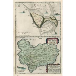
HELGELANDIA Helgelandt in annis Christi 800, 1300 & 1649
This map by Johannes Blaeu illustrates the impact of flooding on Helgelandia (modern day Heligoland), in the southeast corner of the North Sea. The area depicted is a sma...
Date: 1666
Selling price: ????
Please login to see price!
Sold in 2023
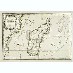
Carte de l'Isle Madagascar dite autrement Madecale et de S. Laurens et aujourd'hui l'Isle Dauphine avec les Coste de Cofala et du Mozambique en Afrique . . .
Uncommon map of the island Madagascar with the African coast countries Mozambique and Cofala. Numerous place names, soundings and sand banks are shown round the island an...
Date: Paris, 1666
Selling price: ????
Please login to see price!
Sold in 2013
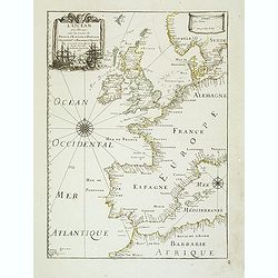
L'Ocean près d'Europe avec les Costes de France, d'Espagne, de Portugal, d'Angleterre, de Hollande, de Danemarc, & cie . . .
Attractive chart by Pierre Du Val shows the North Atlantic Ocean and the coast of Europe from Scandinavia and Great Britain down to France, Spain, the Mediterranean and N...
Date: Paris, 1666
Selling price: ????
Please login to see price!
Sold
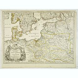
Les Royaumes du Nort ou Sont principalement les estats de la Couronne de Pologne. . .
Uncommon and detailed map of Poland. With decorative tittle cartouche lower left with a dedication to Jean-Jacques de Mesmes, comte d'Avaux (1640 – 9 January 1688) who ...
Date: Paris, c.1666
Selling price: ????
Please login to see price!
Sold in 2012
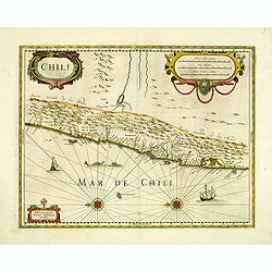
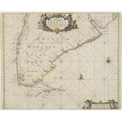
Chili.
Johannes Janssonius' very decorative map of Chili with two large and beautiful cartouches, a compass and ships. The modern cities of Santiago (identified on the map as &q...
Date: Amsterdam, 1666
Selling price: ????
Please login to see price!
Sold in 2012
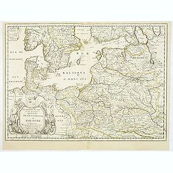
Les Royaumes du Nort ou Sont principalement les estats de la Couronne de Pologne. . .
Uncommon and detailed map of Poland. With decorative title cartouche lower left with a dedication to Jean-Jacques de Mesmes, comte d'Avaux (1640 – 9 January 1688) who w...
Date: Paris, c.1666
Selling price: ????
Please login to see price!
Sold in 2012
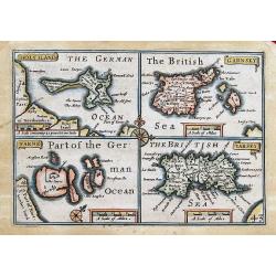
HOLYILAND; GARNSEY; FARNE; IARSEY;
"Miniature Speed" four maps one page: of Holy Island and Lindisfarne, the Channel Islands: Guernsey (including Herm & Sark) and Jersey. Very charming maps, ...
Date: London, 1666
Selling price: ????
Please login to see price!
Sold in 2013
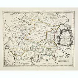
Illyricum Orientis In quo Partes II. Moesia et Thracia. Provinciae XI.
Attractive historical map of the area west of the Black Sea, today's Bulgaria, Rumania, etc. Based on the cartography of Nicolas Sanson and published by P.Mariette. With ...
Date: Paris, 1666
Selling price: ????
Please login to see price!
Sold in 2020
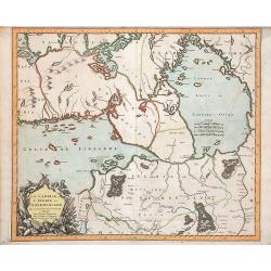
La Carelie et l'Ingrie, ou Ingermenland.
Depicts the gulf of Finland, Lake Ladoga and the River Neva. Pre-Saint Petersburg map.
Date: Paris, P.Mariette, 1666
Selling price: ????
Please login to see price!
Sold in 2018
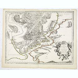
Anaplus Bosphori Thracii. . .
Detailed map of the Bosporus during ancient time. Lower left Istanbul. Prepared by Guillaume Sanson, the son of Nicolas.
Date: Paris, ca.1666
Selling price: ????
Please login to see price!
Sold in 2013
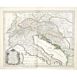
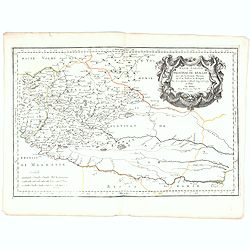
Illyricum Occidentis. Cuj Partes IV Rhaetia, Noricum Pannonia, et Illyris. . .
Attractive historical map of the area Balkans, Hungary, Austria, the Adriatic and the northern part of Italy. Engraved by Louis Cordier. Based on the cartography of Nicol...
Date: Paris, 1666
Selling price: ????
Please login to see price!
Sold in 2013
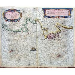
De Noordwest zyde van Yerlandt Beginnende van Capo de Hoorn; tot aen Schynes of Slyynhead . . .
A large, rare chart of part of the northwest coast of Ireland, including Achill Island, Donegal and Sligo.Originally produced by Theunisz Jacobsz for his Lichtende Colomn...
Date: Amsterdam, 1666
Selling price: ????
Please login to see price!
Sold in 2019
Geographia Synodica, Sive Regionum, Vrbium, et Locorum vbi Celebrata Sunt Concilia Oecumenica, Nationalia, Provincialia et Synodi Dioecesanae
Attractive historical map of Europe, the Mediterranean, and northern Africa. Extends to Cyprus and the Holy Land. Based on the cartography of Guillaume Samson and publish...
Date: Paris, 1666
Selling price: ????
Please login to see price!
Sold in 2020
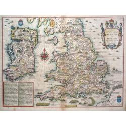
The Invasions of England and Ireland.
The Invasions of England and Ireland with all their Civill Wars since the Conquest.A finely engraved hand colored map with an attractive title cartouche that is surmounte...
Date: London, c 1666
Selling price: ????
Please login to see price!
Sold in 2014
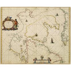
Paskaert Zynde de Noordelijckste Zeekusten van America van Groenland door de Straet Davis en de Straet Hudson tot Terra Neuf . . .
An eye-catching chart of North America, covering the approaches to Hudson Bay and the North West Passage. Including Greenland.Pieter Goos (ca. 1616-1675) was one of the m...
Date: Amsterdam, 1666
Selling price: ????
Please login to see price!
Sold in 2021
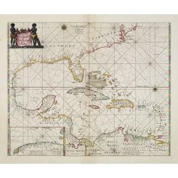
Pascaerte van Westindien de vaste kusten en de eylanden.
A general chart of the West Indies. In the lower left-hand corner an inset (184x96mm.) of the strait between Cuba and the southernmost tip of Florida. A rare and decorati...
Date: Amsterdam, 1666
Selling price: ????
Please login to see price!
Sold in 2013
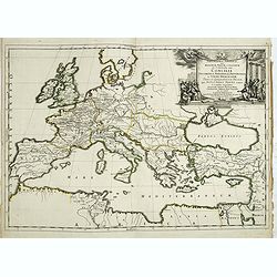
Geographia Synodica, Sive Regionum, Vrbium, et Locorum vbi Celebrata Sunt Concilia Oecumenica, Nationalia, Provincialia et Synodi Dioecesanae
Attractive historical map of Europe, the Mediterranean, and northern Africa. Extends to Cyprus and the Holy Land. Based on the cartography of Guillaume Samson and publish...
Date: Paris, 1666
Selling price: ????
Please login to see price!
Sold in 2016

Pascaart van Europa alsmede een gedeelte vande Kust van Africa. . .
An eye-catching chart of the entirety of Europe's coastline from northern Russia to Yugoslavia in the south. Also showing the West Coast of Africa as far as the Cape-Verd...
Date: Amsterdam, after 1666
Selling price: ????
Please login to see price!
Sold in 2023
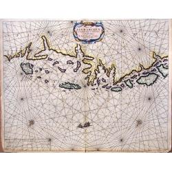
Caarte van Finmarcken van 't Eylandt Sanien tot Noordkyn...
Uncommon chart depicting the coast of Finnmark, in Norway.A decorative title cartouche, rhumb lines, three vessels and two compass roses. Published 1666 by J. Theunisz an...
Date: Amsterdam, 1666
Selling price: ????
Please login to see price!
Sold in 2018
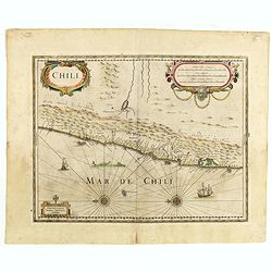
Chili.
Johannes Janssonius' very decorative map of Chili with two large and beautiful cartouches, a compass and ships. The modern cities of Santiago (identified on the map as &q...
Date: Amsterdam, 1666
Selling price: ????
Please login to see price!
Sold in 2015
Pascaert Vande Caribes Eylanden.
A fine seventeenth century sea chart of the islands of the Caribbean, including Puerto Rico, the Virgin Islands, Barbados, Guadeloupe, Trinidad, Tobago, the Lesser Antill...
Date: Amsterdam, 1666
Selling price: ????
Please login to see price!
Sold in 2016
![Finlande septentr[iona]le et Mérid[iona]le, Nylande, et Tavasthus. . .](/uploads/cache/36574-250x250.jpg)
Finlande septentr[iona]le et Mérid[iona]le, Nylande, et Tavasthus. . .
Map of the southern part of Finland, including Helsinki, Salo, Turku, etc.
Date: Paris, Mariette, 1666
Selling price: ????
Please login to see price!
Sold in 2017
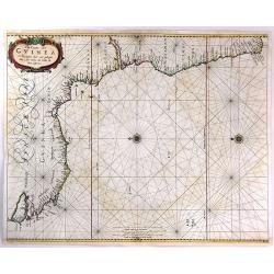
Pas-Caart van Guinea en de Custen daer aen gelegen Van Cabo verde tot Cabo de Bona Esperanca.
A rare sea chart of the southwest coast of Africa from the Guinea Coast down to the Cape of Good Hope, covering Guinea, Sierra Leone, Liberia, the Ivory Coast, Ghana, Nig...
Date: Amsterdam, 1666
Selling price: ????
Please login to see price!
Sold in 2016
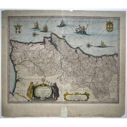
Portugallia et Algarbia quæ olim Lusitania. Auctore Vernando Alvero Secco.
An attractive map of Portugal, orientated with north to the right. The cartography is based on Fernando Alvarez Secco, a Portuguese chart maker whose 1560 map was used by...
Date: Amsterdam, 1666
Selling price: ????
Please login to see price!
Sold in 2016
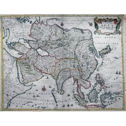
A New and Exact Map of Asia and the Islands there unto belonging.
SIGNIFICANTLY SCARCE map of Asia by Václav Hollar, also known as Hollar Wenceslaus, one of finest engravers of his time. Born in Bohemia, he moved to England to become a...
Date: London, ca. 1666
Selling price: ????
Please login to see price!
Sold in 2016
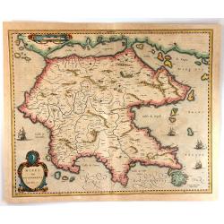
Morea Olim Peloponnesus
An attractive map of the Peloponnesos peninsula in southern Greece that was called Morea until well into the 19th century. The narrow isthmus between the mainland and the...
Date: Amsterdam, 1666
Selling price: ????
Please login to see price!
Sold in 2016
![Pascaerte van NOVA HISPANIA PERV en CHILI [California as an island].](/uploads/cache/97818-250x250.jpg)
Pascaerte van NOVA HISPANIA PERV en CHILI [California as an island].
California as an island on second Sanson model, with indented northern coast. Agubela de Cato is peninsula to its north.Possibly copied from Blaeu's map of 1648, as was D...
Date: Amsterdam, 1666
Selling price: ????
Please login to see price!
Sold in 2020

Abramo Ortellio.
Portrait of Abraham Ortelius (1528-1598) published in "Elogii D' Hvomini Letterati Scritti", by Lorenzo Crasso.Abraham Ortel, better known as Ortelius, was born...
Date: Venice, 1666
Selling price: ????
Please login to see price!
Sold in 2017

Francesco Baconi Baron di Verulamio.
Portrait of Francis Bacon, published in "Elogii D' Hvomini Letterati Scritti", by Lorenzo Crasso.Called the father of empiricism, Sir Francis Bacon is credited ...
Date: Venice, 1666
Selling price: ????
Please login to see price!
Sold in 2021
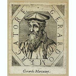
Gerado Mercatore.
Rare portrait of Gerard Mercator (1512-1594) published in "Elogii D' Hvomini Letterati Scritti", by Lorenzo Crasso.
Date: Venice, 1666
Selling price: ????
Please login to see price!
Sold in 2017

Nicola Copernico.
Portrait of Nicola Copernico. Rare portrait of the Polish astronomer Nicolaus Copernicus published in "Elogii D' Hvomini Letterati Scritti", by Lorenzo Crasso.A...
Date: Venice, 1666
Selling price: ????
Please login to see price!
Sold in 2020
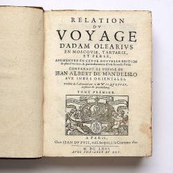
Relation du voyage en Moscovie, Tartarie, et Perse, augmentee en cette nouvelle edition... Le voyage de Jean Albert de Mandelslo aux Indes Orientales.
Complete title 'Relation du voyage en Moscovie, Tartarie, et Perse, augmentee en cette nouvelle edition... Le voyage de Jean Albert de Mandelslo aux Indes Orientales. Tra...
Date: Paris, 1666
Selling price: ????
Please login to see price!
Sold in 2017
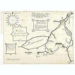
Plans des forts faicts par le régiment Carignan Salières sur la rivière de Richelieu dicte autrement des Iroquois en la Nouvelle France.
Published in François Le Mercier "Relation de ce qui s’est passé en la Nouvelle France, és années 1664 & 1665", Paris, Sébastien Cramoisy et Sébasti...
Date: Paris, Sebastien Cramoisy & Sebastien Mabre-Cramoisy, 1666
Selling price: ????
Please login to see price!
Sold in 2018
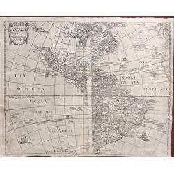
Americæ descriptio nova.
This map shows California as an island. A re-engraved version of a map previously published for Henri Seille in 1652. The map appears in Peter Heylyn's “Cosmography in ...
Date: London, 1666
Selling price: ????
Please login to see price!
Sold in 2018
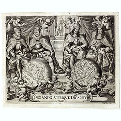
Ornando Vtrique Dicantur. (frontispiece with globes)
Very decorative frontispiece from "Historia Coelestis" (1666), by the German astronomer Albert Curtz (1600-1671), described the work carried out by the Danish a...
Date: Augustae Vindelicorum, Apud Simonem Utzschneiderum, 1666
Selling price: ????
Please login to see price!
Sold in 2019
Haute, ou Petite Pologne ou sont les Palatinats de Cracow, Sandomirie, et Lublin . . .
Regional map of a portion of Poland, including the Palatinats of Cracow, Sandomirie, and Lublin. Engraved by J.Sommer.Nicolas Sanson was to bring about the rise of French...
Date: Paris, 1666
Selling price: ????
Please login to see price!
Sold in 2019
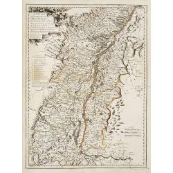
L'Alsace, ou Conquestes du Roy en Allemagne..
"Fine map of the French, German and Swiss region Alsace, engraved by R. Cordier d'Abbauil. Including the towns of Strasbourg, Basle, Colmar, etc. The cartouche is de...
Date: Paris 1666
Selling price: ????
Please login to see price!
Sold in 2009
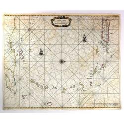
Paskaarte van Het Zuydelijckste van America..
A good copy of this scarce of the Southern tip of South America. The map also depicts a sailing ship at sea and a compass rose.
Date: Amsterdam, 1666
Selling price: ????
Please login to see price!
Sold in 2012