Browse Listings
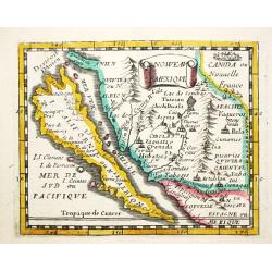
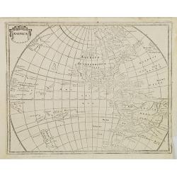
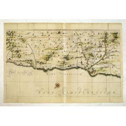
Nouveau Mexique.
Piere du Val (1618-83), Paris-based cartographer and publisher. Atlases a.o. 'Cartes de Géographie', 1654-88, 'La Géographie universelle', 1661-1712. After his death, h...
Date: Paris, 1661.Paris, 1661
Selling price: ????
Please login to see price!
Sold in 2008
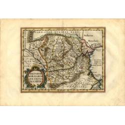
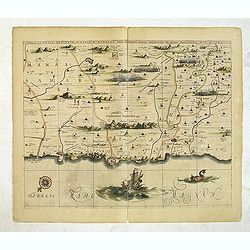
Daciarum Moesiarum que, Vetus Descriptio.
Handsome small map of the ancient region of Romania and Bulgaria based on Ortelius' map of the same title. Filled with old place names and embellished with a fine title c...
Date: Amsterdam, 1661
Selling price: ????
Please login to see price!
Sold in 2008
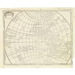
America.
Map of America with California as an island. Interesting map from a German edition of Philipp Clüver's famous Introductionis in Universam geographicam, first published i...
Date: Wolfenbüttel, ca. 1661
Selling price: ????
Please login to see price!
Sold in 2021

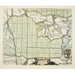
Agri Biemstrani Descriptio a L.I.S.
Detailed map of the polder Beemster in Noord Holland. Including the towns of Purmerend, De Ryp, Oudendijk, etc.
Date: Amsterdam, 1661
Selling price: ????
Please login to see price!
Sold in 2019
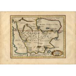
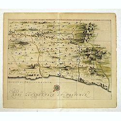
Arabia Eudaemon ex Plinio Lib VI Cap. 28. Orbis terrarum
Charming small map of the Arabian Peninsula is decorated with a strapwork title cartouche. Sparse detailing reflects the lack of knowledge of the geography other than the...
Date: Amsterdam, 1661
Selling price: ????
Please login to see price!
Sold in 2008
America.
Interesting map from a German edition of Philipp Clüver's famous Introductionis in Universam geographicam, first published in Leiden in 1624. Philipp Clüver (1580-1623)...
Date: Wolfenbüttel, ca. 1661
Selling price: ????
Please login to see price!
Sold in 2008
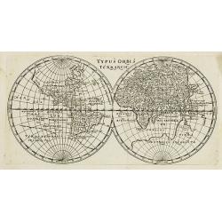
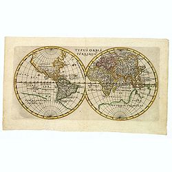
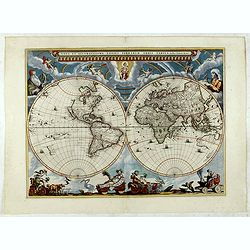
Typus Orbis Terrarum.
Interesting world map in two hemispheres from a German edition of Philipp Clüver\'s famous Introductionis in Universam geographicam, first published in Leiden in 1624. P...
Date: Wolfenbüttel, 1661
Selling price: ????
Please login to see price!
Sold in 2008
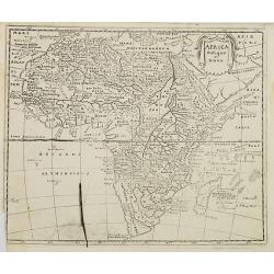
Africa antiqua et Nova.
Interesting map of Africa from a German edition of Philipp Clüver's famous Introductionis in Universam geographicam, first published in Leiden in 1624. Philipp Clüver (...
Date: Wolfenbüttel, later than 1661
Selling price: ????
Please login to see price!
Sold in 2008
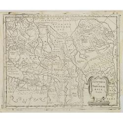
Scythia et Tartaria Asiatica.
Interesting map of Tartary and Scythia from a German edition of Philipp Clüver's famous Introductionis in Universam geographicam, first published in Leiden in 1624. Phil...
Date: Wolfenbüttel, 1661
Selling price: ????
Please login to see price!
Sold in 2009
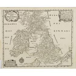
Veteris et nova Britannia descriptio.
Interesting map of the British islands from a German edition of Philipp Clüver's famous Introductionis in Universam geographicam, first published in Leiden in 1624. Phil...
Date: Wolfenbüttel, 1661
Selling price: ????
Please login to see price!
Sold in 2008
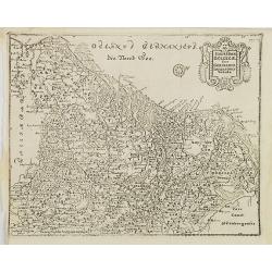
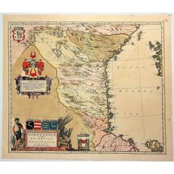
Hodiernae Belgicae sive Germaniae Infezrioris Tabula.
Interesting map of the Low Countries from a German edition of Philipp Clüver's famous Introductionis in Universam geographicam, first published in Leiden in 1624. Philip...
Date: Wolfenbüttel, 1661
Selling price: ????
Please login to see price!
Sold in 2008
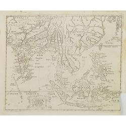
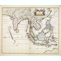
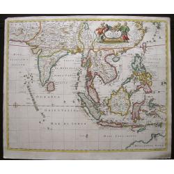
Indiae Orientalis et Insularum Antiqua et nova Descriptio.
Interesting map of South East Asia, including Indonesia, India, Taiwan from a German edition of Philipp Clüver's famous Introductionis in Universam geographicam, first p...
Date: Wolfenbüttel, 1661
Selling price: ????
Please login to see price!
Sold in 2009
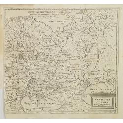
Sarmatia et Scythia Russia et Tartaria Europaa.
Interesting map of Scythia and Sarmatia from a German edition of Philipp Clüver's famous Introductionis in Universam geographicam, first published in Leiden in 1624. Phi...
Date: Wolfenbüttel, 1661
Selling price: ????
Please login to see price!
Sold in 2008
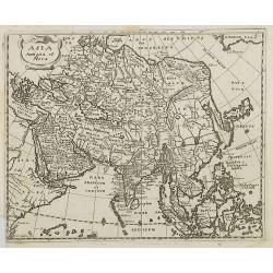
Asia Antiqua et Nova.
Interesting map of Asia from a German edition of Philipp Clüver\'s famous Introductionis in Universam geographicam, first published in Leiden in 1624. Philipp Clüver (1...
Date: Wolfenbüttel, 1661
Selling price: ????
Please login to see price!
Sold in 2008
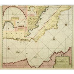
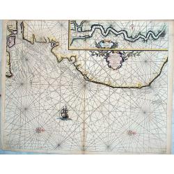
Pascaart van de Zee Kusten van Granada en Murcia..
Decorative and uncommon chart including the African and the Spanish coast. In top four insets of Almay, Buzema, Zasarinos Islands and Cartagena. A fifth large inset cover...
Date: Amsterdam, 1661
Selling price: ????
Please login to see price!
Sold in 2010
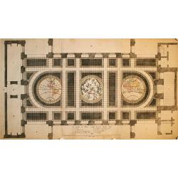
De Grondt en Vloer vande Groote Burger Sael
This unique sheet depicts three maps that were laid in the marble floor of Amsterdam Town Hall. At center is a celestial map of the northern sky with the Western and East...
Date: Amsterdam, 1661
Selling price: ????
Please login to see price!
Sold in 2009
Ultraiectum Dominium.
Based on the map by B.F.van Berckenrode (1620-21).
Date: Amsterdam, 1661
Selling price: ????
Please login to see price!
Sold in 2021
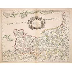
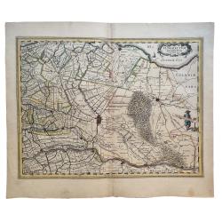
Duche et Gouvernement de Normandie. . .
Fine map of Normandy.This edition carries the date 1661, engraved by R.Cordier.Nicolas Sanson was to bring about the rise of French cartography, although the fierce compe...
Date: Paris, 1661
Selling price: ????
Please login to see price!
Sold
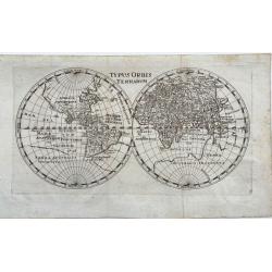
Typus Orbis Terrarum.
Nice, uncommon map of the world in two hemispheres by P. Cluver. Published in Wolfenbüttel by J. Buno, 1661. With title at the top. It shows a huge Antarctic region. Man...
Date: Wolfenbüttel, 1661
Selling price: ????
Please login to see price!
Sold in 2020
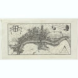
Londinum London.
A delightful and attractive small 17th century 'bird's-eye plan of London, by Rutger Hermannides; from his Britannia Magna sive Angliae, Scotiae, Hiberniae & Adjacent...
Date: Amsterdam, 1661
Selling price: ????
Please login to see price!
Sold in 2022
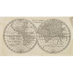
Typus Orbis Terrarum.
Interesting world map in two hemispheres from a German edition of Philipp Clüver's famous Introductionis in Universam geographicam, first published in Leiden in 1624. Ph...
Date: Wolfenbüttel, 1661
Selling price: ????
Please login to see price!
Sold in 2016
Caerte van de Scher-meer Alsoo deselve is Bedyckt, ende by Cavels van 15 Morgen suyver landt door lotinge uytgedelt, op den 25 October Anno 1635, ende aldus met groote verbeteringe int licht gegeven.
Attractive map of the polder Schermer near Alkmaar by Cornelis Ian allers Bogaert and published by Blaeu. At the lower right side a coat of arms of Schermer. In the lower...
Date: Amsterdam, 1661
Selling price: ????
Please login to see price!
Sold in 2019
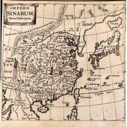
Imperii Sinarum Nova Descriptio.
Detailed small map of China engraved by Bertius.
Date: Amsterdam, 1661
Selling price: ????
Please login to see price!
Sold in 2012
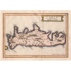
Creta
A small historical map of Crete with a simple strapwork title cartouche. The map is based on the cartography of Ubbo Emmius, who worked for Hondius and Jansson, and engra...
Date: Amsterdam 1661
Selling price: ????
Please login to see price!
Sold in 2014
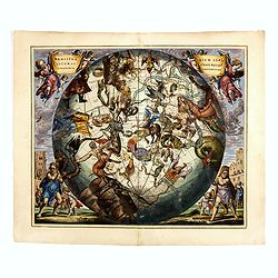
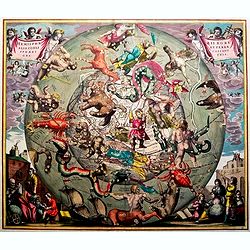
Haemisphaerium Stellatum Australe Cum Aequali Sphaerarum Proportione.
The very rare first edition, first state of this spectacular celestial chart showing the constellation of the southern hemisphere superimposed upon a globe depicting Amer...
Date: Amsterdam, J.Janssonius, 1661
Selling price: ????
Please login to see price!
Sold in 2014
Hemisphaerii Borealis Coeli et Terrae Sphaeri Cascenographia.
Andreas Cellarius (active from 1656-1702), Dutch mathematician and geographer, rector of the Latin School at Hoorn. He may have been of German or Polish origin, with the ...
Date: Amsterdam, 1661
Selling price: ????
Please login to see price!
Sold in 2016
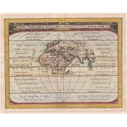
Orbis Terrarum Veteribus Cogniti Typus Geographicus.
This map of the classical World is based upon Abraham Ortelius' ancient map of the World, which was later re-issued by Jan Jansson. This is a reduced version of the map. ...
Date: Amsterdam, 1661
Selling price: ????
Please login to see price!
Sold in 2018
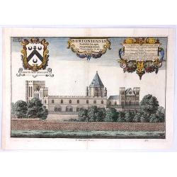
Burtoniensis ecclesiae, (in agro Staffordiensi)
A very decorative copper engraving of Burton-upon-Trent, England, engraved by Hollar, from Dugdale's book, published in London in 1661. Decorated with three beautiful car...
Date: London, 1661
Selling price: ????
Please login to see price!
Sold in 2016
![[Title page] ARCANO DEL MARE](/uploads/cache/81880-250x250.jpg)
[Title page] ARCANO DEL MARE
Decorative folio title page from Robert Dudley's "Dell’arcano del mare, an encyclopedic work on navigation with an atlas of maps drawn on the Mercator projection. ...
Date: Florence, 1661
Selling price: ????
Please login to see price!
Sold in 2018
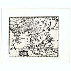
Indiae Orientalis et Insularum Antiqua et nova Descriptio.
Interesting map of South East Asia, including Indonesia, India, Taiwan, Philippines from Philipp Clüver's famous Introductionis in Universam geographicam, first publishe...
Date: Wolfenbüttel, 1661
Selling price: ????
Please login to see price!
Sold in 2020
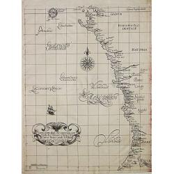
Carte particolare che comincia con l'Isole di S. Tomasso e Tome e c. d' S. Clara e finisce con il. c. d' Aldeas.
Chart of Gabon, Congo, Zaire and Angola] Carte particolare che comincia con l'Isole di S. Tomasso e Tome e c. d' S. Clara e finisce con il. c. d' Aldeas. Description: Rob...
Date: Florence, 1661
Selling price: ????
Please login to see price!
Sold in 2019
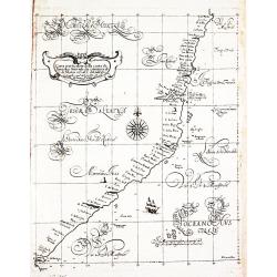
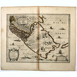
(The coast of Argentina from Cape S. Andreas to Golfo San Jorge.)
A chart from Robert Dudley's sea-atlas Arcano del Mare. It depicts the coast of Argentina from Cape S. Andreas in lattitude 39 o S. to Golfo San Jorge.Robert Dudley (1574...
Date: Florence, 1661
Selling price: ????
Please login to see price!
Sold in 2019
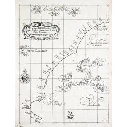
Carta particolare d'Argentina che comincia con il capo S. Andrea e¨ finisce con il capo Matas d'America.
Robert Dudley (1574-1649). English cartographer. The Arcano del Mare (Mystery of the Sea) is "ONE OF THE GREATEST ATLASES OF THE WORLD": it is the first sea-atl...
Date: Florence, 1661
Selling price: ????
Please login to see price!
Sold in 2019
![[Atlantic Ocean] Carta particolare dell mare Oceano fra la costa di Guinea e la Brasilia.](/uploads/cache/81883-250x250.jpg)
[Atlantic Ocean] Carta particolare dell mare Oceano fra la costa di Guinea e la Brasilia.
A large, small-scale, so-called cross-over chart of the Atlantic Ocean on two sheets. From Robert Dudley's atlas Arcano del Mare, with the coast of Africa and the eastern...
Date: Florence, 1661
Selling price: ????
Please login to see price!
Sold in 2019
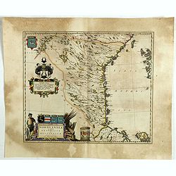
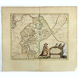
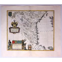
Nordlandiae et quibies Gestricia et Helsingicae regiones.
It shows the east central part of Sweden Gästrikland and Hälsingland). The body of water to the east is the Gulf of Bothnia.The map is enhanced by a number of decorativ...
Date: Amsterdam, 1661
Selling price: ????
Please login to see price!
Sold in 2019
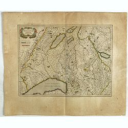
Das Wiflispurgergow.
A lovely detailed map of South-western Switzerland after Gerhard Mercator's map of the same. With an ornamental title cartouche and Dutch text on the verso. It shows Gene...
Date: Amsterdam, ca 1661
Selling price: ????
Please login to see price!
Sold in 2019
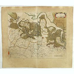
Kaerte van de vier ambachten.
Uncommon map of the ‘Vier Ambachten’ in Zeeuws-Vlaanderen. The map covers the area of IJzendijke, Biervliet, Sas van Gent, Axel, Hulst, Lillo and parts of Zuid-Bevela...
Date: Amsterdam, 1661
Selling price: ????
Please login to see price!
Sold in 2019
Kiangsi Imperii Sinarum provincia octava. (Kiangsi)
Prepared 1655 by Martino Martini and published by Joan Blaeu in his Atlas Maior. A fine map of Jiangxi (Kiangsi) Province in China. The map depicts the region from the Ya...
Date: Amsterdam, 1661
Selling price: ????
Please login to see price!
Sold in 2020
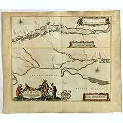
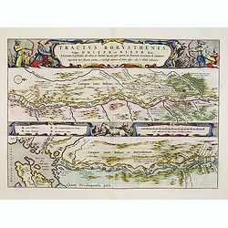
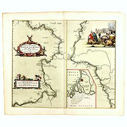
Tractus Borysthenis vulgo Dniepr et Niepr Dicti, à Kiovia ufque ad Bouzin.
This superb map shows the upper part of the Dnieper River in two horizontal strips, the upper map with a compass rose orienting the map, west to the top. It is richly emb...
Date: Amsterdam, 1661
Selling price: ????
Please login to see price!
Sold in 2020
![[Poland, region between Glogaw and Wartenberg] Baronatus Carolato Bethaniensis. . .](/uploads/cache/42503-250x250.jpg)
[Poland, region between Glogaw and Wartenberg] Baronatus Carolato Bethaniensis. . .
This superb map including the river Oder with Glogów, Nowa Sól and Wartenberg in southwestern Poland. Glogów County, in Lower Silesian Voivodeship, was previously in L...
Date: Amsterdam, 1661
Selling price: ????
Please login to see price!
Sold in 2021
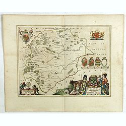
Rutlandia Comitatus. Rutland Shire.
One of the most decorative maps of the county Rutlandshire, with armorials, a scale cartouche and a rustic title cartouche It is richly embellished with an elaborate titl...
Date: Amsterdam, 1661
Selling price: ????
Please login to see price!
Sold in 2020
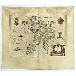
Comitatus Caernarvoniensis, Vernacule Carnarvon-Shire et Mona Insula Vulgo Anglesey.
One of the most decorative maps of Caernarvonshire and Anglesey with present-day Gwynedd and Mon. The map is embellished with the Royal Arms, the crest and feathered crow...
Date: Amsterdam, 1661
Selling price: ????
Please login to see price!
Sold in 2020
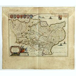
Cantium Vernacule Kent.
of the county of Kent. The map is embellished with the Royal Arms, the crest and feathered crown of the Prince of Wales. The decorative title and scale cartouche features...
Date: Amsterdam, 1661
Selling price: ????
Please login to see price!
Sold in 2020
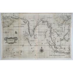
Carta prima Generale dell' Asia.
A rare sea chart of India and Indonesia, in a first state. The chart appeared in Dudley's Arcano del Mare, one of the rarest and most highly sought after sea atlases of t...
Date: Florence, 1641/1661
Selling price: ????
Please login to see price!
Sold in 2019
Typus Orbis Terrarum.
An interesting world map in two hemispheres from a German edition of Philipp Clüver's famous Introductionis in Universam geographicam, first published in Leiden in 1624....
Date: Wolfenbüttel, 1661
Selling price: ????
Please login to see price!
Sold in 2020
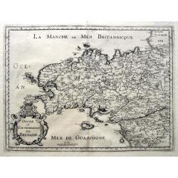
Duche et Gouvernement de Bretagne.
An unusual map published shortly after the very similar map by Sanson. Very detailed, filled with place names, rivers, woods, islands, etc. From Martin Zeiller's Topograp...
Date: Frankfurt, ca 1661
Selling price: ????
Please login to see price!
Sold in 2019
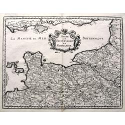
Duche et Gouvernement de Normandie.
A fine map published in Martin Zeiller's Topographia Galliae. Very detailed, filled with place names, rivers, woods, islands, etc. Extends just until Paris, includes the ...
Date: Frankfurt, ca 1661
Selling price: ????
Please login to see price!
Sold in 2019
Dimidia Tribus Manasse Ultra Iordanem, Tribus Neptalim et partes orientales tribuum Zabulon et Isachar.
One sheet of the six sheet map by Georgius Hornius map of the Holy Land. Each of the maps is embellished with countless vignettes and other images drawn from Biblical tra...
Date: Amsterdam, Janssonius, 1662
Selling price: ????
Please login to see price!
Sold in 2013
Tribus Aser, et partes occidentales tribuum Zabulon et Isachar.
One sheet of the six sheet map by Georgius Hornius map of the Holy Land. Each of the maps is embellished with countless vignettes and other images drawn from Biblical tra...
Date: Amsterdam, Janssonius, 1662
Selling price: ????
Please login to see price!
Sold in 2014
Tribuum Ephraim, Beniamin, et Dimidiae Manasse intra Iordanem partes occidentales, et partes septentrionales Dan et Iuda.
One sheet of the six sheet map by Georgius Hornius map of the Holy Land. Each of the maps is embellished with countless vignettes and other images drawn from Biblical tra...
Date: Amsterdam, Janssonius, 1662
Selling price: ????
Please login to see price!
Sold in 2013
Tribus Simeon et pars meridionalis Tribus Dan, et orientalis Tribus Idua.
One sheet of the six sheet map by Georgius Hornius map of the Holy Land. Each of the maps is embellished with countless vignettes and other images drawn from Biblical tra...
Date: Amsterdam, Janssonius, 1662
Selling price: ????
Please login to see price!
Sold in 2014
Hornius Map of the Holy Land, Israel, and Palestine.
A fine example of the six sheet map by Georgius Hornius map of the Holy Land. Each of the maps is embellished with countless vignettes and other images drawn from Biblica...
Date: Amsterdam, Janssonius, 1662
Selling price: ????
Please login to see price!
Sold in 2018
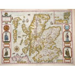
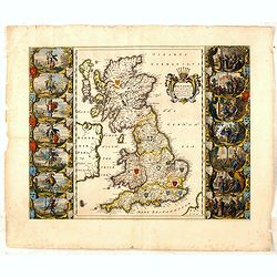
The Kingdome of Scotland.
Attractive rare "carte à figures"- map of Scotland embellished with the portraits of A Scotch man, A Highland Man, A Scotch Woman, and a Highland Woman.English...
Date: London, 1662
Selling price: ????
Please login to see price!
Sold in 2012
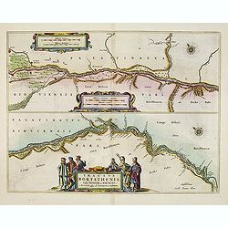
Tractus Borysthenis vulgo Dniepr et Niepr Dicti, à Bovzin . . .
This superb map shows the lower part of the Dniepr River, extending to the Black Sea in two horizontal strips, the upper map with a compass rose orienting the map, west t...
Date: Amsterdam, 1662
Selling price: ????
Please login to see price!
Sold in 2012

Tractus Borysthenis vulgo Dniepr et Niepr Dicti, à Kiovia ufque ad Bouzin.
This superb map shows the upper part of the Dnieper River in two horizontal strips, the upper map with a compass rose orienting the map, west to the top. It is richly emb...
Date: Amsterdam, 1662
Selling price: ????
Please login to see price!
Sold in 2012
Tractus Borysthenis vulgo Dniepr et Niepr Dicti, à Bovzin . . .
This superb map shows the upper part of the Dnieper River in two horizontal strips, the upper map with a compass rose orienting the map, west to the top. It is richly emb...
Date: Amsterdam, 1662
Selling price: ????
Please login to see price!
Sold in 2012
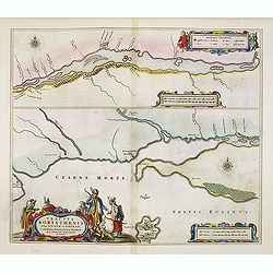
Tractus Borysthenis vulgo Dniepr et Niepr Dicti, à Chortika Ostro ad Urbem Oczakow . . .
This superb map shows the upper part of the Dnieper River in two horizontal strips, the upper map with a compass rose orienting the map, west to the top. It is richly emb...
Date: Amsterdam, 1662
Selling price: ????
Please login to see price!
Sold in 2012
Pascaerte van Engelant vant Voorland tot aen Blakeney, waer in te sien is de mont vande Teemse. . .
Rare chart showing the West coast of England and the mouth of the River Thames. The upper right inset shows the Thames from London into the North Sea. With decorative flo...
Date: Amsterdam, 1662
Selling price: ????
Please login to see price!
Sold in 2018

Effigies Tychonis Brahe O.F. Aedificii et Instrumentorum Astronomicorum structoris. A°. Domini 1587, Aetatis Sue 40.
Showing Tycho Brahe in his observatory on the Danish island of Hven.From volume one of the great "Atlas Major" published by Joan Blaeu. This volume contained al...
Date: Amsterdam, 1662
Selling price: ????
Please login to see price!
Sold in 2013
Tabula Indiae Orientalis.
An attractive and decorative map covering all South East Asia engraved by Johannes Lhuilier. The map encompasses the region from India to Southern China, Taiwan and the P...
Date: Amsterdam, 1662
Selling price: ????
Please login to see price!
Sold in 2015
Nova & accurata Wolgae fluminis, olim Rha dicti, delineatio / auctore Adamo Oleario.
Joan Blaeu's copper plate showing a map of the Volga River in three parts based on the travels of Adam Olearius. The left side of the map begins at Nazhniy Novgorod and e...
Date: Amsterdam, 1662
Selling price: ????
Please login to see price!
Sold in 2014
![[Title page]: Europa.](/uploads/cache/35606-250x250.jpg)
[Title page]: Europa.
Attractive title page of Blaeu's Atlas Major volume on Europe. Very decorative, and finely engraved print of the familiar legend of the maiden Europa witch depict a woman...
Date: Amsterdam, 1662
Selling price: ????
Please login to see price!
Sold in 2015
Britannia prout divisa suit temporibus Anglo-Saxonum, præsertim durante illorum Heptarchia.
Blaeu's decorative map shows the British Isles at the time of the Anglo-Saxon Heptarchy; the seven ancient kingdoms of Kent, the South Saxons, West Saxons, East Saxons, N...
Date: Amsterdam, 1645-1662
Selling price: ????
Please login to see price!
Sold in 2015
Nova et Accuratissima Totius Terrarum Orbis Tabula.
Since its appearance as an Appendix in 1630, the atlas launched by Willem Blaeu and continued by his son Joan had expanded greatly. But in spite of many new regional maps...
Date: Amsterdam, 1662
Selling price: ????
Please login to see price!
Sold in 2015
Tabula Indiae Orientalis
An attractive and decorative map covering all South East Asia engraved by Johannes Lhuilier. The map encompasses the region from India to Southern China, Taiwan, and the ...
Date: Amsterdam, 1662
Selling price: ????
Please login to see price!
Sold in 2016
Freti Magellanici ac novi Freti vulgo Le Maire..
A fine map of Tierra del Fuego. With a Dutch translation of the explanatory text of the passage by Barent Jansz. Potgieter who accompanied captain Sebald de Weert to the ...
Date: Amsterdam, ca. 1662
Selling price: ????
Please login to see price!
Sold in 2016
![Nobilibus Amplissimis Q. Dominis D. Georgio De La Faille Toparchae Deneuele &c. Praetori Totiq. Colllegio Supremae Curiae Feudalis Regiae Veteris Burgi Gandensis [Gent]](/uploads/cache/38732-250x250.jpg)
Nobilibus Amplissimis Q. Dominis D. Georgio De La Faille Toparchae Deneuele &c. Praetori Totiq. Colllegio Supremae Curiae Feudalis Regiae Veteris Burgi Gandensis [Gent]
Fine map centered on Gent in Flandres with inset "Graven Kasteel". From Blaeu's Atlas Major.
Date: Amsterdam, 1662
Selling price: ????
Please login to see price!
Sold in 2019
Norlandiae et Quibies Gestricia et Helsingicae Regiones.
A striking, rare map with a cartouche dedicated to Gabriel Bengtsson Oxenstierna. The 'Atlas Maior' is the epitome of decades of achievement by the famous Blaeu family. P...
Date: Amsterdam, 1662
Selling price: ????
Please login to see price!
Sold in 2017
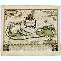
Mappa Aestivarum Insularum alias Barmudas.
Blaeu based his work on John Speed's remarkably accurate map of 1626-1627. It shows the island divided into tribes and lots, and below the map itself appear the names of ...
Date: Amsterdam, 1662
Selling price: ????
Please login to see price!
Sold in 2017
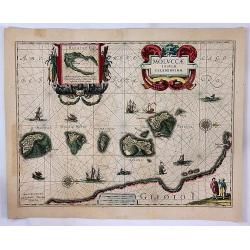
Moluccae Insulae Celeberrimae.
A striking map of the famous Spice Islands, originally described by Van Linschoten. This map was the first large-scale map of the region and depicts the islands that prov...
Date: Amsterdam, 1662
Selling price: ????
Please login to see price!
Sold in 2017

Geographia Blaviana.
Title page from "Geographia Blaviana" An attractive title page of Johan Blaeu's 'Atlas Major'. Very decorative, and finely engraved with allegorical representat...
Date: Amsterdam, 1662
Selling price: ????
Please login to see price!
Sold in 2017
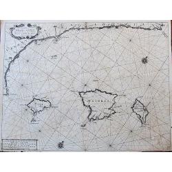
De Custen van Valencia en Catalonia van C. de S. Martyn tot C. Dragonis, als meede de Eylanden van Majorca, Minorca en Yvica.
Important early Dutch sea chart by Goos from his important Atlas Zee-spiegel. Includes the northeastern coast of Spain with Valencia, Tarragona, and Barcelona. With the B...
Date: Amsterdam, ca. 1662
Selling price: ????
Please login to see price!
Sold in 2017
Leodiensis Dioecesis.
A map of Liege, a province in Belgium. A splendidly decorative map of the Muese River and valley, including Namur and Liege, with west oriented at top of map. Franchimo...
Date: Amsterdam, 1662
Selling price: ????
Please login to see price!
Sold in 2018
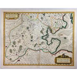
Oldenburg Comitatus.
An attractive map of the region of Oldenburg and Bremen, showing the Jadebusen, and the estuary of the Weser. The topography and towns are beautifully detailed with nice ...
Date: Amsterdam, 1662
Selling price: ????
Please login to see price!
Sold in 2018
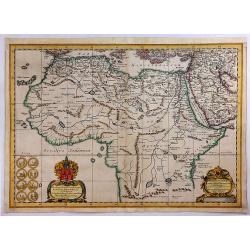
Africae Antiquae, et quarundam Europae Asiaeque Adiacentium Regionum.
A striking map of the northern and central portion of the African continent. The source of the Nile, on the Ptolemaic model, begins from the lakes Zaire and Zaflan, near ...
Date: Amsterdam, 1662
Selling price: ????
Please login to see price!
Sold in 2018
Nordlandiae et Quibies Gestricia et Helsingicae Regiones.
A fine antique map of Sweden or Norrland, with two originally colored cartouches, a figured title cartouche and a heraldic cartouche, with a total of six coats-of-arms in...
Date: Amsterdam, 1662
Selling price: ????
Please login to see price!
Sold in 2018
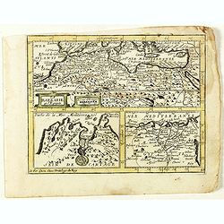
La Barbarie et l'Egypte.
Scarce map of the African coastline of the Mediterranean, with two inset maps Egypt and Carthage published by Antoine de Fer in 1661 or 1662 in "Cartes de géographi...
Date: Paris, Antoine de Fer, 1657 but 1661 or 1662
Selling price: ????
Please login to see price!
Sold in 2020
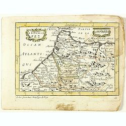
Le Royaume de Fez. (11).
Scarce map of the kingdom of Fes in Morocco published by Antoine de Fer in 1661 or 1662 in "Cartes de géographie revues et augmentées". With Antoine de Fer's ...
Date: Paris, Antoine de Fer, 1657 but 1661 or 1662
Selling price: ????
Please login to see price!
Sold in 2020
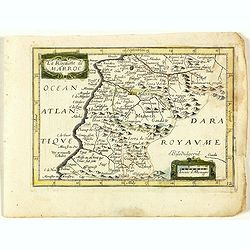
Le Royaume de Maroc. (12).
Scarce map of Morocco published by Antoine de Fer in 1661 or 1662 in "Cartes de géographie revues et augmentées". With number 12 in lower right bottom of the ...
Date: Paris, Antoine de Fer, 1657 but 1661 or 1662
Selling price: ????
Please login to see price!
Sold in 2020
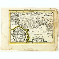
Guinee. (13).
Scarce map of Guinea published by Antoine de Fer in 1661 or 1662 in "Cartes de géographie revues et augmentées". With number 13 in lower right bottom of the m...
Date: Paris, Antoine de Fer, 1657 but 1661 or 1662
Selling price: ????
Please login to see price!
Sold in 2020