Browse Listings
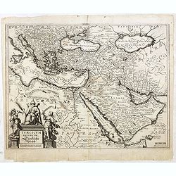
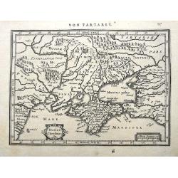
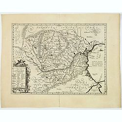
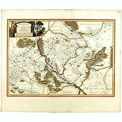
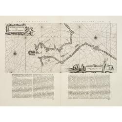
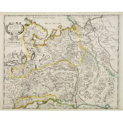
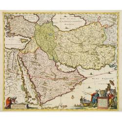
Turcicum Imperium. Türckische Reijch.
A reduced version of Blaeu's map of the Middle East. The map extends from the Mediterranean to Arabia and is notable for the fine title cartouche bottom left surmounted b...
Date: Frankfurt, 1660
Selling price: ????
Please login to see price!
Sold in 2015
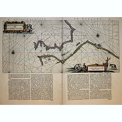
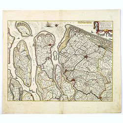
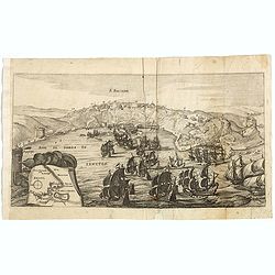
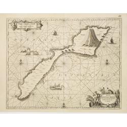
Fretum Nassovium vulgo de Straet Nassou.
Decorative map of the Nassau Strait, from the Atlas Major. Includes 2 compass roses, sailing ship.
Date: Amsterdam, 1660
Selling price: ????
Please login to see price!
Sold in 2018
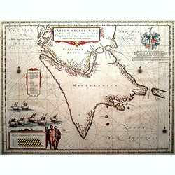
Tabula Magellanica, qua Tierra del fuego. . .
A map with Willem Blaeu's signature, but published by his son Joan, of South America's extremity with the Strait of Magellan and Le Maire Strait.The coastlines are depict...
Date: Amsterdam, 1660
Selling price: ????
Please login to see price!
Sold in 2016

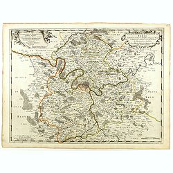
Patriae Antiuae Inter Iuly et Caroli Magni Caesarium Romanorum Tempora Descriptio
An iInteresting map by Jan Janssonius of the “Low Countries and Northern Germany”. The compass rose orients this map with north to the right. The map describes the p...
Date: Amsterdam, 1660
Selling price: ????
Please login to see price!
Sold in 2016
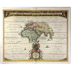
Orbis Terrarum Veteribus Cogniti Typus Geographicus.
A beautifully engraved classic map of the ancient world, based on an earlier chart by Ortelius. Africa, Asia and Europe as far south as Northern Madagascar are placed at ...
Date: Amsterdam, 1660
Selling price: ????
Please login to see price!
Sold in 2016
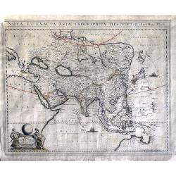
Nova et Exacta Asiae Geographica Descriptio Auct Hugo Allardt
A very rare, large map depicting Asia and an early northern part of Australia.Among the peculiarities of the map are a fine representation of the Philippines, while Korea...
Date: Amsterdam, ca. 1660
Selling price: ????
Please login to see price!
Sold in 2016
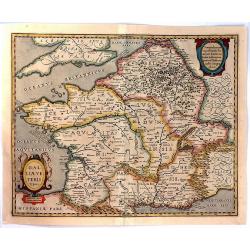
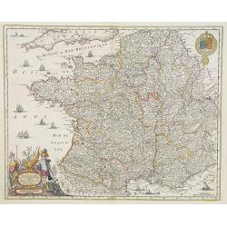
Galliae Veteris Typus.
A pleasing Latin map of France during Roman times, based on Ortelius' map, which in turn was based on ancient geographical sources. The map is filled with detail and anci...
Date: Amsterdam, 1660
Selling price: ????
Please login to see price!
Sold in 2016
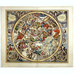
Coeli Stellati Christiani Haemisphaerium Posterius.
Rare first issue. This spectacular celestial chart presents the constellations according to Christian symbolism. The view of the constellations is based on the work of th...
Date: Amsterdam, 1660
Selling price: ????
Please login to see price!
Sold
Ukrainae pars quae Pokutia Vulgo dicitur.
This is a scarce map of the western parts of Ukraine and vicinity, covering the Carpathian Mountains and extending eastward along the Dniester River to Moldova. Includes ...
Date: Amsterdam, ca. 1660
Selling price: ????
Please login to see price!
Sold in 2017

(Three plates showing tigers, leopards, lion, etc, etc.)
Two pages from the first and only but very important Dutch edition of this curious and comprehensive zoological work, richly illustrated with excellent copper engravings,...
Date: Amsterdam, 1660
Selling price: ????
Please login to see price!
Sold in 2017
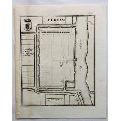
Leerdam.
Small map of fortified Leerdam, located in Gelderland, Holland.
Date: Frankfurt, ca. 1660
Selling price: ????
Please login to see price!
Sold in 2017
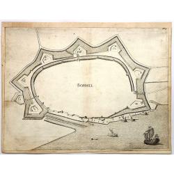
Bommel.
Den Bommel is a village in the Dutch province of South Holland. It is a part of the municipality of Goeree-Overflakkee. This town view is detailed especially in regard to...
Date: Frankfurt, 1660
Selling price: ????
Please login to see price!
Sold in 2018
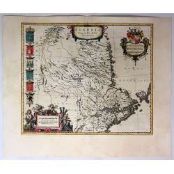
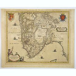
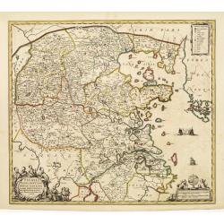
Sueonia Proprie Sie Dicta.
A very decorative map of eastern Sweden. Several beautiful cartouches are displayed. The left side is adorned with six municipal code of arms. There are a total of six pu...
Date: Amsterdam, 1660
Selling price: ????
Please login to see price!
Sold in 2019
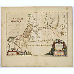
Tabula Itineraria Patriarcharum Abrahami, Isaaci et Jacobi.
The Holy Land and Egypt in left hand part of the map. Showing travels of Abraham, Isaac and Jacob. With some nice decorative cartouches.
Date: Amsterdam, 1660
Selling price: ????
Please login to see price!
Sold in 2017
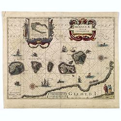
MOLUCCAE Insulae Celeberrimae.
A highly decorative map of the "Spice Islands".
Date: Amsterdam, ca. 1660
Selling price: ????
Please login to see price!
Sold in 2018
Comitatuum Boloniae et Guines Descriptio. / Bolonia & Guines Comitatus. / Territorium Metense . .
[Three maps] The first of this handsome set of maps has west is orientated to the top. Very fine copper engraved map by one of the acknowledged masters of seventeenth cen...
Date: Amsterdam, ca. 1620 - 1660
Selling price: ????
Please login to see price!
Sold in 2018
Delflandia, Schielandia. . .
This detailed road map shows the estuary of the River Maas and extends.
Date: Amsterdam, ca. 1660
Selling price: ????
Please login to see price!
Sold in 2017
Pars Flandriae Teutonicae.
A fine map of Flemish Flanders with the city of Dunkerque shown and a huge fleet of 39 ships. The interior is well engraved with forests and towns, and extends to the Lys...
Date: Amsterdam, 1660
Selling price: ????
Please login to see price!
Sold in 2018
Taurica Chersonesus.
A copper engraved map of the central Ukraine from the "Atlas Minor" (Gerhard Mercator / Jodocus Hondius). Extends from Cherkassy to Crimea and the Sea of Azov. ...
Date: Amsterdam, ca. 1609 -1660
Selling price: ????
Please login to see price!
Sold in 2018
Diocese, Prevoste, et Eslection de Paris . . .
A good engraved map of Ile de France region, centered on Paris.
Date: Paris, 1660
Selling price: ????
Please login to see price!
Sold in 2020
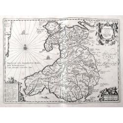
Cambriae Typus Auctore Humfredo Lhuydo.
Fantastic early map of Wales with sailing ships, a sea monster, compass rose, several putti, and an ornamental title cartouche. The map shows numerous towns, rivers, hill...
Date: Amsterdam, ca. 1660
Selling price: ????
Please login to see price!
Sold in 2018
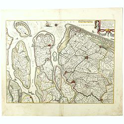
Delflandia, Schielandia. . .
This detailed road map shows the estuary of the River Maas and extends from 's-Gravenhage to Gouda in the north and from Ouddorp to Steenbergen in the south. Cities, such...
Date: Amsterdam, ca. 1660
Selling price: ????
Please login to see price!
Sold in 2018
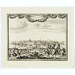
Stockholm.
An excellent and rare copperplate view of the Swedish capitol from the Afbeeldinghe der voornaemste steden van Europa.It shows a group of wealthy noblemen in the foregrou...
Date: Amsterdam, ca 1660
Selling price: ????
Please login to see price!
Sold in 2018
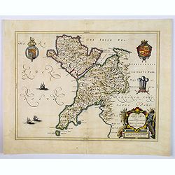
Comitatus Caernarvoniensis, Vernacule Carnarvonshire. Et Mona insula Vulgo Anglessey.
The detailed and decorative Blaeu double-page map of Caernarvon & Anglesey, with a decorative title cartouche depicting a farmer with his harvest, royal armorials and...
Date: Amsterdam, ca 1660
Selling price: ????
Please login to see price!
Sold in 2019
Dioecensis Stavangriensis. . .
A fine and decorative map of southern Norway from 61 deg. N. with Oslo, Stavanger and Bergen prominently shown. The map presents a vivid view of the fjords and mountains ...
Date: Amsterdam, ca 1660
Selling price: ????
Please login to see price!
Sold in 2019
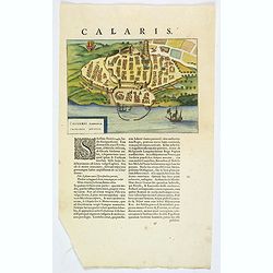
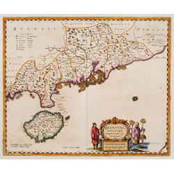
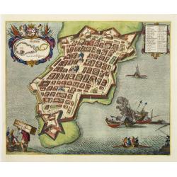
Caliaris Sardiniae. Primaria Civitas.
A delightful small town plan of the Sardinian capital city of Cagliari by Blaeu, published in the mid-seventeenth century. The plan shows inner and outer fortified city w...
Date: Amsterdam, ca 1660
Selling price: ????
Please login to see price!
Sold in 2019
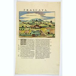
Citta di Frascate.
A delightful small town view of the central Italian city of Frascati by Blaeu, published in the mid-seventeenth century. The view shows a small walled town, with building...
Date: Amsterdam, ca 1660
Selling price: ????
Please login to see price!
Sold in 2021

La Place de Loüis le grand ou des conquestes.
View of "La Place de Loüis le grand ou des conquestes" in Paris, published by I. Mariette. Showing the statue of Louis XIV in the center.
Date: Paris, 1660
Selling price: ????
Please login to see price!
Sold
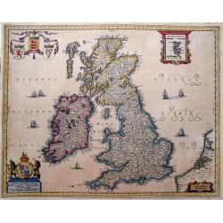
Nieuwe en Perfeckte Caerte van Engelandt Schotlandt en Yerlandt. . .
A fine and decorative map of the British Isles. Embellished with sailing ships, coats of arms, and an inset map of the Orkney Islands.Hugo Allard (1625-1691) was a capabl...
Date: Amsterdam, ca 1660
Selling price: ????
Please login to see price!
Sold in 2019
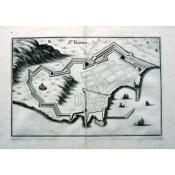
St. Tropez.
An early copper engraved plan of Saint-Tropez. Shows a few buildings, the layout of the streets, the city walls, and the harbour with sailing ships.
Date: Frankfurt, ca 1660
Selling price: ????
Please login to see price!
Sold in 2019
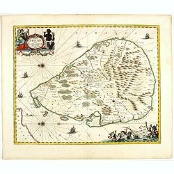
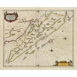
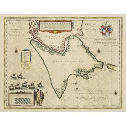
Insula Zeilan olim Taprobana nunc incolis tenarisim.
Janssonius' map of Sri Lanka. Including many VOC settlements and forts, several major town marked with a crown. Very decorative item, with two large title and scale carto...
Date: Amsterdam, 1660
Selling price: ????
Please login to see price!
Sold in 2019
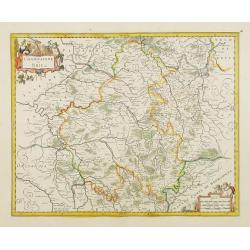
Vetus Descriptio Daciarum Nec non Moesiarum. . .
A decorative map of ancient Dacia and Moesia, namely today's Romania, with Serbia and part of Bulgaria, With a beautiful cartouche. Signed lower part: Petrus Kaerius Cael...
Date: Amsterdam, ca 1660
Selling price: ????
Please login to see price!
Sold in 2020
S. SALVADOR.
Charming view of Salvador de Bahia, in Brazil, seen from the ocean. In lower left inset map of Baia de todos os Sanctos.
Date: Frankfurt, 1660
Selling price: ????
Please login to see price!
Sold in 2020
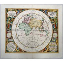
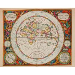
Hemisphaerium Orbis Antiqui Cumzonis Circulis et Situ Populorum Diverso.
A wonderfully colored example of Andreas Cellarius's map of the Eastern Hemisphere, illustrating the climatic zones ranging from Frigida Borealis to Torrida, with planeta...
Date: Amsterdam, 1660
Selling price: ????
Please login to see price!
Sold in 2019
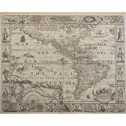
A New Plaine and Exact Map of America.
A very rare map with portraits and views on all sides, published by Robert Walton (1618-1688), London, ca. 1660. Second State.Robert Walton was one of a handful of map pu...
Date: London, 1660
Selling price: ????
Please login to see price!
Sold in 2020

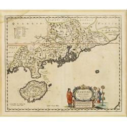
Xantung, sinarum imperii provincia quatra.
A map of the northern province ‘Xantung’ of China after the Jesuit Martino Martini.Shows the Great Wall and is centered on the Bohai Sea, and the Shandong and Liaonin...
Date: Amsterdam, ca 1660
Ukrainae pars quae Kiovia Palatinatus.
This is a scarce Joan Blaeu first edition of the map of the Kiev region of Ukraine and vicinity. Signature of Joan Blaeu in the lower part of the map. This map was origin...
Date: Amsterdam, ca. 1660
Selling price: ????
Please login to see price!
Sold
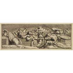
Rome and soldiers.
Engraving by Pietro (di) Santo Bartoli, showing a frieze with Roman soldiers. After a drawing by Julio Romano. Iacintus Paribenius Pistorien formis Romae.
Date: Rome, c.1660
Selling price: ????
Please login to see price!
Sold
Champaigne et Brie etc.
A good engraved map of Champagne-Ardennes area, embellished with decorative title cartouche and scale cartouche with putti and surveying instruments. Paris, Metz, Reims, ...
Date: Amsterdam, 1660
Selling price: ????
Please login to see price!
Sold in 2011
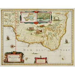
Accuratissima Brasiliae Tabula..
A decorative map with a title cartouche of two natives: the interior features scenes of native life, among napping in a hammock, warfare, cannibalism and indigenous wild ...
Date: Amsterdam 1660
Selling price: ????
Please login to see price!
Sold
![Harlemum vulgo Haerlem. [Haarlem]](/uploads/cache/15745-250x250.jpg)
Harlemum vulgo Haerlem. [Haarlem]
Fine plan of Haarlem. Lower left a numbered key (1-67).From JANSSONIUS RARE town book of the Netherlands. Copied after the plan of Blaeu, but much rarer.
Date: Amsterdam 1660
Selling price: ????
Please login to see price!
Sold
Quantung Imperii Sinarum Provincia duodecima.
A beautifully engraved map of Southern China covering Hainan and the Pearl River Delta with Macao and the islands around present-day Hong Kong.
Date: Amsterdam 1660
Selling price: ????
Please login to see price!
Sold
Gallia. Nova et accurata descriptio vulgo Royaume de France.
Fine map of France with in upper right corner the coats of arms of France.
Date: Amsterdam, 1660
Selling price: ????
Please login to see price!
Sold in 2011
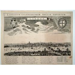
London. Londinum celeberrimum Angliae Emporium.
A rare panoramic view of London with over the whole length of the lower part 3 columns of poems in Latin, Dutch and French and a numbered key 1-43 to the principal buildi...
Date: Amsterdam, 1660
Selling price: ????
Please login to see price!
Sold
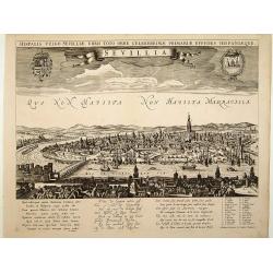
Sevillia.
A rare panoramic view of Seville with over the whole length of the lower part 3 columns of poems in Latin, Dutch and French and a numbered key 1-28 to the principal build...
Date: Amsterdam, 1660
Selling price: ????
Please login to see price!
Sold
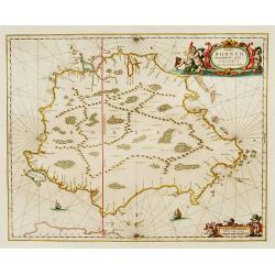
Insula BORNEO et occidentalis pars celibis cum adjacentibus Insulis.
An elegant map of Borneo. The map includes only coastal detail.The beautiful map is richly embellished with two fine cartouches featuring mermaids surrounding the scale o...
Date: Amsterdam 1660
Selling price: ????
Please login to see price!
Sold
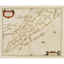
Sumatrae et insularum Locorumque nonnullorum circumiacentium
Fine chart depicting the Island of Sumatra and the southern coasts of Malaysia from Quedo to Johore. North is orientated to the left of the page. Singapore is probably id...
Date: Amsterdam 1660
Selling price: ????
Please login to see price!
Sold
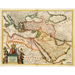
Turcicum Imperium. Türckische Reijch.
A reduced version of Blaeu's map of the Middle East.The map extends from the Mediterranean to Arabia and is notable for the fine title cartouche bottom left surmounted by...
Date: Frankfurt 1660
Selling price: ????
Please login to see price!
Sold
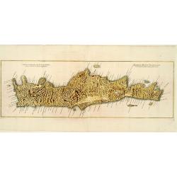
Genuina delineatio insulae Cretae..
A beautifully engraved map of Crete.
Date: Frankfurt 1660
Selling price: ????
Please login to see price!
Sold
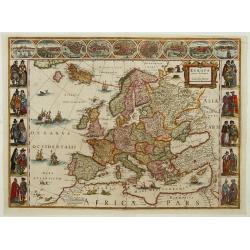
Europa recens descripta a Guilielmo Blaeuw.
On either side columns depicting the manner of dress in the major countries of Europe, surmounted by nine city views and plans. For European mapmakers their own continent...
Date: Amsterdam, 1660
Selling price: ????
Please login to see price!
Sold
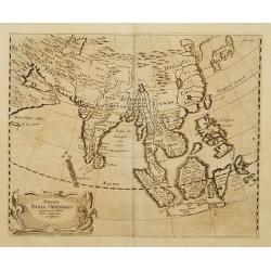
Delineatio Indiae Orientalis quaelumen dabit huie itinerario et historijs.
Uncommon map of Asia from a German edition of Olearius' travels.
Date: Germany c.1660
Selling price: ????
Please login to see price!
Sold
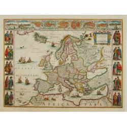
Europa recens descripta a Guilielmo Blaeuw.
On either side columns depicting the manner of dress in the major countries of Europe, surmounted by nine city views and plans. For European mapmakers their own continent...
Date: Amsterdam 1660
Selling price: ????
Please login to see price!
Sold
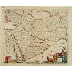
Nova Persiae, Armeniae, Natoliae et Arabiae.
East from Cyprus to Iran with numerous place names and ornamental cartouches below. There are vignettes of sailing ships in sea areas and the land divisions of the time a...
Date: Amsterdam 1660
Selling price: ????
Please login to see price!
Sold
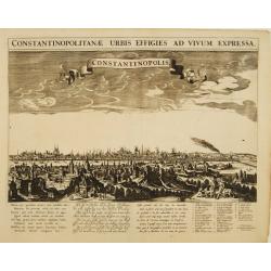
Constantinopolitanae urbis effigies ad vivum expressa.
A rare panoramic view of Istanbul with over the whole length of the lower part 3 columns of poems in Latin, Dutch and French and a numbered key 1-29 to the principal buil...
Date: Amsterdam, 1660
Selling price: ????
Please login to see price!
Sold
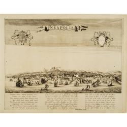
Neapolis.
A rare panoramic view of Naples with over the whole length of the lower part 3 columns of poems in Latin, Dutch and French.Published by Dancker Danckerts (1634-1666)Colle...
Date: Amsterdam, 1660
Selling price: ????
Please login to see price!
Sold
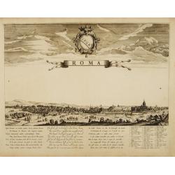
Roma.
A rare panoramic view of Rome with over the whole length of the lower part 3 columns of poems in Latin, Dutch and French and a numbered key 1-42 to the principal building...
Date: Amsterdam, 1660
Selling price: ????
Please login to see price!
Sold
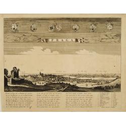
Praga.
A rare panoramic view of Prague with over the whole length of the lower part 3 columns of poems in Latin, Dutch and French and a numbered key 1-34 to the principal buildi...
Date: Amsterdam, 1660
Selling price: ????
Please login to see price!
Sold
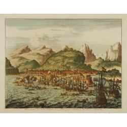
Het veroveren der stadt Allegona in 't eylandt groot Canaria, in den Jaere MDXCIX.
The town Las Palmas on Gran Canaries taken by a Dutch fleet in 1649
Date: Netherlands c.1660
Selling price: ????
Please login to see price!
Sold
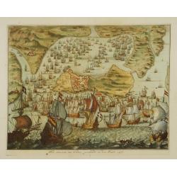
Het innemen van Cadix, geschiedt in den Jaere 1596.
Engraving of the capture and sacking of Cadiz by an English fleet under the Earl of Essex, Lord Howard of Effingham and Francis Vere. The harbour is literally filled with...
Date: Netherlands c.1660
Selling price: ????
Please login to see price!
Sold
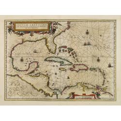
Insulae Americanae in oceano septentrionali..
Finely engraved map, showing the Gulf of Mexico and the West Indian Islands, and the adjacent North and South American coastlines.The cartography is based on the rare Ger...
Date: Amsterdam 1660
Selling price: ????
Please login to see price!
Sold
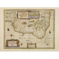
Accuratissima Brasiliae Tabula.
A decorative map of Brazil with a title cartouche of two natives: the interior features scenes of native life, among napping in a hammock, warfare, cannibalism and indige...
Date: Amsterdam 1660
Selling price: ????
Please login to see price!
Sold
Fretum Nassovium vulgo de Straet Nassou.
Decorative map of the Nassau Strait, from the Atlas Major. Includes 2 compass roses, sailing ships, rhumb lines and 2 elaborate cartouches. Latin text below and on verso.
Date: Amsterdam 1660
Selling price: ????
Please login to see price!
Sold
Insulae Joannis Mayen cum universo situ Sinuum et Promontoriorum.
From the Atlas Major.
Date: Amsterdam 1660
Selling price: ????
Please login to see price!
Sold
Hemispherium Orbis Antiqui, Cumzonis Circulis, Et Sity populorum Diverso.
The magnificent celestial atlas produced by Andreas Cellarius ?Atlas Coelestis seu Harmonia Macrocosmica? is the only celestial atlas published in the heydays of Dutch ca...
Date: Amsterdam, Johannes Janssonius, 1660
Selling price: ????
Please login to see price!
Sold
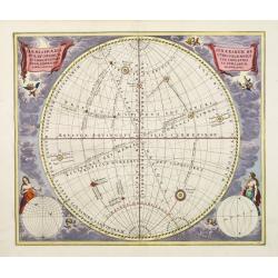
Haemisphaeria sphaerarum rectae et oblique utriusque motus..
A celestial chart depicting the location of the planets and stars according to ecliptic co-ordination and celestial-equator co-ordination. Two planispheres in lower corne...
Date: Amsterdam 1660
Selling price: ????
Please login to see price!
Sold
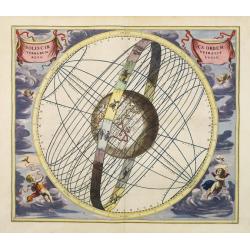
Soliscirca orbem terrarum spiralis revolutio.
A most decorative, uncommon chart, showing the Eastern Hemisphere in the centre, including part of Australia and Japan and with the equatorial circle, the tropical circle...
Date: Amsterdam 1660
Selling price: ????
Please login to see price!
Sold
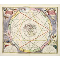
Typus aspectuum, oppositionum et conjunctionum..
A celestial chart with a circular projection map of the earth, centred in the North Pole, concentrating upon the opposition and conjunction of the planets. With two diagr...
Date: Amsterdam 1660
Selling price: ????
Please login to see price!
Sold
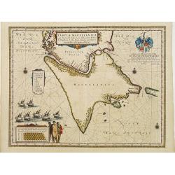
Tabula Magellanica.
A map with Willem Blaeu's signature, but published by his son Joan, of South America's extremity. A dedication to Constantijn Huygens.
Date: Amsterdam 1660
Selling price: ????
Please login to see price!
Sold
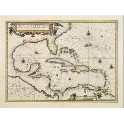
Insulae Americanae in oceano septentrionali..
Finely engraved map, showing the Gulf of Mexico and the West Indian Islands, and the adjacent North and South American coastlines.The cartography is based on the rare Ger...
Date: Amsterdam 1660
Selling price: ????
Please login to see price!
Sold
Carte de la grande Russie ou Moscovie..
Uncommon map centred on Moscow from the first folio French produced world atlas. Prepared by P.du Val and engraved by A.Peyrounin.Pierre Mariette purchased in 1644 the bu...
Date: Paris 1660
Selling price: ????
Please login to see price!
Sold
Valetta Civitas Nova Maltae olim Millitae.
A beautifully engraved and richly detailed birds-eye plan of the harbour and city of Valletta seen from the northwest. Left hand corner map of Malta and Gozo with decorat...
Date: Amsterdam, ca. 1660
Selling price: ????
Please login to see price!
Sold in 2020
Sumatrae et insularum Locorumque nonnullorum circumiacentium..
Fine chart depicting the Island of Sumatra and the southern coasts of Malaysia from Quedo to Johore.North is orientated to the left of the page.Singapore is probably iden...
Date: Amsterdam 1660
Selling price: ????
Please login to see price!
Sold
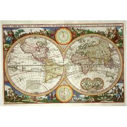
Orbis Terrarum Typus..
This map is a direct derivative of Nicolas Visscher's first world map designed for inclusion in Dutch Bibles. It has been re-engraved, is nominally larger, and this examp...
Date: Amsterdam c.1660
Selling price: ????
Please login to see price!
Sold
Nova Persiae, Armeniae, Natoliae et Arabiae.
East from Cyprus to Iran with numerous place names and ornamental cartouches below. There are vignettes of sailing ships in sea areas and the land divisions of the time a...
Date: Amsterdam, 1660
Selling price: ????
Please login to see price!
Sold in 2013
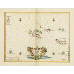
Insulae Açores delineante Ludovico Teisera.
Detailed map of the Azores, dedicated to L.Teisera. A later impression after which the copper plated suffered from several cracks, clearly visible on this strike. Includi...
Date: Amsterdam 1660
Selling price: ????
Please login to see price!
Sold
Tabula Magellanica..
A map with Willem Blaeu's signature, but published by his son Joan, of South America's extremity with the Strait of Magellan and Le Maire Strait.The coastlines are depict...
Date: Amsterdam 1660
Selling price: ????
Please login to see price!
Sold
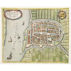
Schoonhoven.
A bird's eye view of the town of Schoonhoven. With short key list inside the title cartouche.Latin text on verso.
Date: Amsterdam, 1660
Selling price: ????
Please login to see price!
Sold in 2010
Pecheli, Xansi, Xantung, Honan, Nanking, In plaga Regni Sinensis..
A map of the northern provinces of China after the Jesuit Martino Martini, Beijing, Shandong, Hanan and Jiangsu.Shows the Great Wall and covers northeastern China includi...
Date: Amsterdam ca 1660
Selling price: ????
Please login to see price!
Sold
Quantung Imperii Sinarum Provincia duodecima.
A beautifully engraved map of Southern China covering Hainan and the Pearl River Delta with Macao and the islands around present-day Hong Kong.
Date: Amsterdam 1660
Selling price: ????
Please login to see price!
Sold
BIBLIA, dat is de gantsche H. Schrifture, vervattende alle de canonijcke boecken des Ouden en des Nieuwen Testaments.
Richly bound copy of the official Dutch 'Staten-Bijbel' after the Synod from Dordrecht. With engraved general title, 2 separate titles, 6 double-page engraved maps by Nic...
Date: Amsterdam, 1660
Selling price: ????
Please login to see price!
Sold