Browse Listings
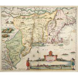
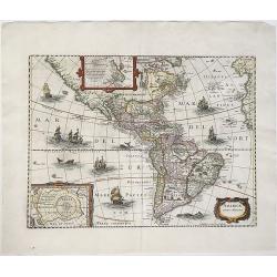
Novi Belgii novae que Angliae nec non partis Virginiae..
The very rare second state: with Fort Kassimier, but without Philadelphia. A classic Dutch map of the east coast from the Chesapeake Bay north to Canada with the famous v...
Date: Amsterdam 1652
Selling price: ????
Please login to see price!
Sold
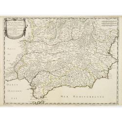
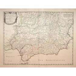
Les Etats de la couronne de Castille.. Andalousie..
Map of Andalusia, with original or early outline hand-color. Numerous place-names of counties, cities, towns, physical features. Prepared by N.Sanson and engraved by Somm...
Date: Paris 1652
Selling price: ????
Please login to see price!
Sold
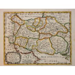
L'Empire du Sophy des Perses. A. Peyrounin Scu.
Nicolas Sanson (1600-67), "father of the French cartography" and founder of the Sanson firm. Atlas "Cartes générales de toutes les parties du Monde"...
Date: Paris, 1652
Selling price: ????
Please login to see price!
Sold in 2010
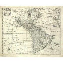
AMERICAE / Descriptio Nova/ Impensis/ Henrici seile/ Will: Trevethen. Sculp/ 1652.
The first state of Henry Seile's map of the Americas, from Peter Heylin's ' Cosmographie '. Reference: Burden, North America, entry and plate 308.
Date: London, 1652
Selling price: ????
Please login to see price!
Sold in 2010
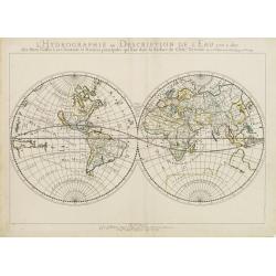
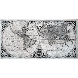
L'Hydrographie ..la Surface du Globe Terrestre.
An unusual double hemisphere hydrological map of the world - the earliest of the world prepared by the great French mapmaker Nicolas Sanson. Of particular interest is the...
Date: Paris 1652
Selling price: ????
Please login to see price!
Sold
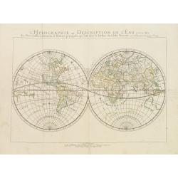
L'Hydrographie ou Description de L'Eau..
An unusual double hemisphere hydrological map of the world, with California as an Island - the earliest of the world prepared by the great French mapmaker Nicolas Sanson....
Date: Paris 1652
Selling price: ????
Please login to see price!
Sold
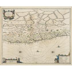
![[Cartouche cutting from ] Insulae Iavae Cum parte insularum Borneo Sumatrae. . .](/uploads/cache/30306-250x250.jpg)
[Cartouche cutting from ] Insulae Iavae Cum parte insularum Borneo Sumatrae. . .
A cut-out of the elegant sea chart of the island of Java with parts of Sumatra, Borneo and Bali. The title cartouche featuring natives and merchants.
Date: Amsterdam, 1652
Selling price: ????
Please login to see price!
Sold in 2013
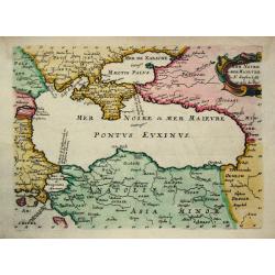
Mer Noire ou Mer Maievre.
Nicolas Sanson (1600-67), ' father of the French cartography' and founder of the Sanson firm. Atlas ' Cartes générales de toutes les parties du Monde', 1658-70 and a po...
Date: Paris, c. 1652
Selling price: ????
Please login to see price!
Sold
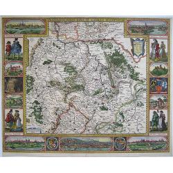
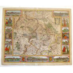
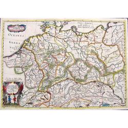
Palatinatus Rheni Nova et Accurata Descriptio
Showing the Rheinland-Pfalz region. With city views of Metz and Frankfurt-am-Main, Worms, Speyer and Heidelberg, and partial views of Heidelberg Castle, the wolf fountain...
Date: Amsterdam, 1652
Selling price: ????
Please login to see price!
Sold in 2008
Les Etats de la couronne de Castille.. Andalousie..
Map of Andalusia, with original or early outline hand-color. Numerous place-names of counties, cities, towns, physical features. Prepared by N.Sanson.
Date: Paris, 1652
Selling price: ????
Please login to see price!
Sold in 2021
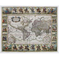
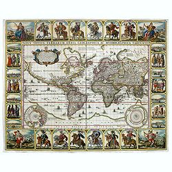
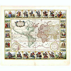
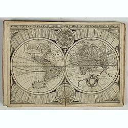
Nova Totius Terrarum Orbis Geographica...
This stunning carte-a-figures world map on Mercator's projection is one of the most richly decorated maps from the Dutch period of pre-eminence in cartography.
Date: Amsterdam 1652
Selling price: ????
Please login to see price!
Sold in 2016
Capitaniarum de Phernambuca, Itama Raca, Paraiba, et Pio Grande Nova Delineatio.
Rare map of part of the coast of Brazil. From Janssonius' 'Atlas Novus'. Rare. Title in cartouche at upper left, scale bars in frame at lower left, and legend in frame at...
Date: Amsterdam, 1652
Selling price: ????
Please login to see price!
Sold in 2009
Nova Totius Terrarum Orbis Geographica. . .
This stunning "carte à figures" world map on Mercator's projection is one of the most richly decorated maps from the Dutch period of pre-eminence in cartograph...
Date: Amsterdam, 1652
Selling price: ????
Please login to see price!
Sold in 2009
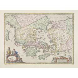
Hellas Seu Graecia Sophiani.
A decorative detailed map of Ancient Greece and the western part of Turkey and Macedonia.
Date: Amsterdam, 1652
Selling price: ????
Please login to see price!
Sold in 2009
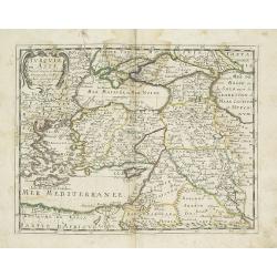
Turquie d'Asie.
Map of Turkey, Greece, Georgia, Black Sea, Cyprus, etc. °
Date: Paris, 1652
Selling price: ????
Please login to see price!
Sold in 2010
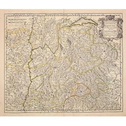
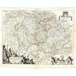
Le gouvernement general du Daufine, et.. La Savoye. . .
Fine map of south eastern part of France and part of Switzerland. Centered on Basle and the Alps.With manuscript number in upper right corner.Nicolas Sanson was to bring ...
Date: Paris, 1652
Selling price: ????
Please login to see price!
Sold
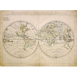
L'Hydrographie ou Description de L'Eau. . .
An unusual double hemisphere hydrological map of the world, with California as an Island - the earliest of the world prepared by the great French mapmaker Nicolaes Sanson...
Date: Paris, 1652
Selling price: ????
Please login to see price!
Sold in 2011
America noviter delineata.
Johannes Janssonius's map of North, Middle and South America. Title in a cartouche at bottom right; beneath it the impressum: 'Amstekodami, Excudit Ioannes Ianssonius'.Sh...
Date: Amsterdam, ca 1652
Selling price: ????
Please login to see price!
Sold in 2020
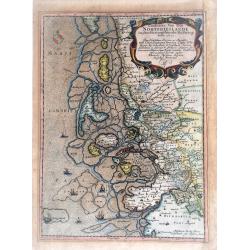
Landtcarte Von dem Nortfrieslande in dem Hertzogthumbe Sleßwig Anno 1651.
A very decorative, rare map showing part of the coastal area of the German North Sea (Nordfriesland). It includes the island of Sylt. From the rare atlas of Mejer Danckwe...
Date: Husum, 1652
Selling price: ????
Please login to see price!
Sold in 2021
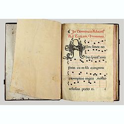
Manuscript Antiphonal on Vellum in Latin.
Manuscript Antiphonal on Vellum in Latin. Folio. Brown suede binding on wooden boards, covers decorated with a double frame of thin gilt dentelles and gilt fleurons, cent...
Date: Toledo, 1652
Selling price: ????
Please login to see price!
Sold in 2022
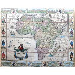
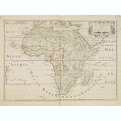
Africae Nova Descr.
Offered is a large, extremely decorativem very rare state of Pieter van den Keere's map of Africa, which was first published in 1614 and was the first folio-sized map of ...
Date: Amsterdam, 1652
Selling price: ????
Please login to see price!
Sold in 2023
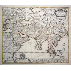
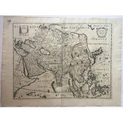
L'Asie.
Map of Asia, from the first edition of the atlas L'Asie en plusieurs cartes nouvelles, et exactes & en divers traittés de Géographie, et d'Histoire.Nicolas Sanson w...
Date: Paris, 1652
Selling price: ????
Please login to see price!
Sold in 2014
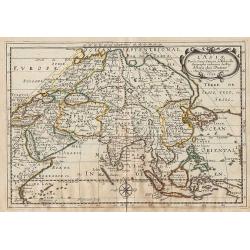
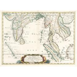
Partie de l'Inde au-delà du Gange. / Presqu'Isle de l'Inde au-delà du Gange.
Two maps together on one sheet. The first depicts north-east India from the gulf of Bengal to the border of China. The second depicts the Malaya Peninsular and Sumatra. F...
Date: Paris, 1652
Selling price: ????
Please login to see price!
Sold in 2012
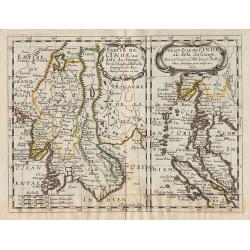
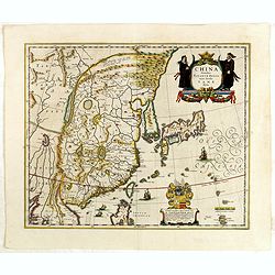
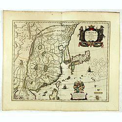
Royaume de la Chine.
Map of the eastern part of China, with Korea shown as an island, from the first edition of the atlas L'Asie en plusieurs cartes nouvelles, et exactes & en divers trai...
Date: Paris, 1652
Selling price: ????
Please login to see price!
Sold in 2014
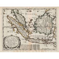
Les Isles de la Sonde. entre lesquelles sont Sumatra, Java, Borneo, &c.
A map covering Indonesia, from the first edition of the atlas L'Asie en plusieurs cartes nouvelles, et exactes & en divers traittés de Géographie, et d'Histoire.Nic...
Date: Paris, 1652
Selling price: ????
Please login to see price!
Sold in 2012
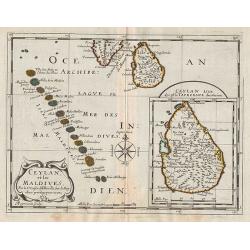
Ceylan, et les Maldives.
Map of the Maldive Islands, with an inset picturing Sri Lanka, from the first edition of the atlas L'Asie en plusieurs cartes nouvelles, et exactes & en divers traitt...
Date: Paris, 1652
Selling price: ????
Please login to see price!
Sold in 2012
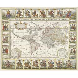
Nova Totius Terrarum Orbis Geographica ac. . .
This stunning carte-a-figures world map on Mercator's projection is one of the most richly decorated maps from the Dutch period of pre-eminence in cartography. While the ...
Date: Amsterdam, 1652
Selling price: ????
Please login to see price!
Sold in 2018
Afrique Par N. Sanson d'Abbevile,
According to Betz, this is a landmark map of Africa, It is the first French map to depict significantly new information. The map is known in one state. The map was prepar...
Date: Paris, ca. 1652
Selling price: ????
Please login to see price!
Sold
TYPUS ORBIS TERRARUM.
Scarce Brunswick edition of Cluvers double hemisphere map of the world! Shirley gives dimensions of 140x280mm for the 1641 edition, our map is slightly larger, so this co...
Date: Brunswick, c1652
Selling price: ????
Please login to see price!
Sold in 2014
Palatinatus Rheni Nova et Accurata Descriptio.
Fine copper engraved map of the Rheinland-Pfalz region of Germany. With city views of Metz, Frankfurt-am-Main, Spier, Heidelberg and Worms. Smaller views of Heidelberg Ca...
Date: Amsterdam, 1652
Selling price: ????
Please login to see price!
Sold in 2014
Asia Antiqua Cum Finitimis Africae Et Europae Regionibus Nicolaus Blancardus Belga Leidensus, Ad Lucem Aevi Vereris Delineabat
An elegant map of ancient Asia. Prepared by Nicolaas Blankaart.
Date: Amsterdam, 1652
Selling price: ????
Please login to see price!
Sold in 2013
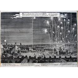
Abriß des Kayserlichen Fewerwercks Schlosses: und Barraquen. . .
Curious view of the fireworks in Nuremberg in 1650 to celebrate the peace after the Thirty Years' War. Shows the barracks and the large square with the city in the backgr...
Date: Frankfurt, 1652
Selling price: ????
Please login to see price!
Sold in 2013
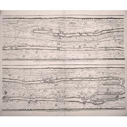
TABVLAE PEVTINGERIANAE SEGMENTVM III. à Marcomannis ad Sarmatas vsque. "Segmentvm IV. à Sarmatis vsque ad Hamaxobios
Sheet 2 of 4 from Peutinger Table, or a Roman road map of the world, "TABVLAE PEVTINGERIANAE SEGMENTVM III. à Marcomannis ad Sarmatas vsque", Segmentvm IV. a&a...
Date: Amsterdam, 1652
Selling price: ????
Please login to see price!
Sold in 2014
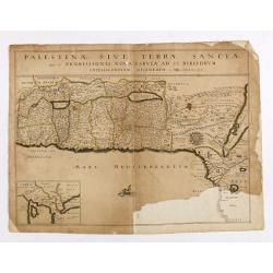
Palestinae sive terrae Sanctae quae et promissionis nova..
Map of the Holy Land, unfortunately with a teared lower corner.Nicolas Sanson was to bring about the rise of French cartography, although the fierce competition of the Du...
Date: Paris, 1652
Selling price: ????
Please login to see price!
Sold in 2014
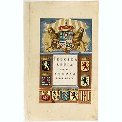
Belgica regia quae est Europae liber nonus.
In top an imposing Spanish royal arms girdled by the Golden Fleece and with a crown surmounted by a cross and orb.
Date: Amsterdam, 1652
Selling price: ????
Please login to see price!
Sold in 2015
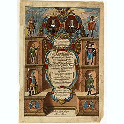
(Title page) Neue Landesbeschreibung der zwei Herzogtümer Schleswig und Holstein. . .
Decorative title page from the earliest printed atlas in Denmark which covers the area Schleswig Holstein from Hamburg up to Kolding in North.
Date: Hüssen, 1652
Selling price: ????
Please login to see price!
Sold in 2018
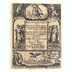
(Title page) Bellum scythico-cosacicu¯ seu, De conjuratione Tartarorum, Cosacorum et plebis russicæ contra regnum Poloniæ, ab invictissimo Poloniæ et Sveciæ rege Ioanne Casimiro profligata^, narratio, plenioris historiæ operi præmissa. . .
Decorative title page engraved by Willem n5wilhelmus) Hondius, who was a Dutch engraver born in The Hague and active in Danzig. Engraver for Guillaume Levasseur de Beaupl...
Date: Dantzig, Georgii Fo¨rsteri, 1652
Selling price: ????
Please login to see price!
Sold in 2018
![Anatolie. [With Cyprus]](/uploads/cache/35962-250x250.jpg)
Anatolie. [With Cyprus]
Attractive scrolled title cartouche to top right corner. Nicolas Sanson (1600-67), "father of the French cartography" and founder of the Sanson firm. Atlas 'Car...
Date: Paris, 1652
Selling price: ????
Please login to see price!
Sold in 2015
![(Chorographia orginis Nili juxta obervationem Odardi Lopez Fol 55. [together with] Chorographia Originis Nili... ex Arabum Geographis deprobpta. Fol. 53 [and] Vera et ...](/uploads/cache/36419-250x250.jpg)
(Chorographia orginis Nili juxta obervationem Odardi Lopez Fol 55. [together with] Chorographia Originis Nili... ex Arabum Geographis deprobpta. Fol. 53 [and] Vera et ...
(Chorographia orginis Nili juxta obervationem Odardi Lopez Fol 55. [together with] Chorographia Originis Nili... ex Arabum Geographis deprobpta. Fol. 53 [and] Vera et Gen...
Date: Amsterdam, 1652
Selling price: ????
Please login to see price!
Sold in 2015
Nova Totius Terrarum Orbis Geographica ac Hydrographica tabula.
This stunning carte-a-figures world map on Mercator's projection is one of the most richly decorated maps from the Dutch period of pre-eminence in cartography. While the ...
Date: Amsterdam, 1652
Selling price: ????
Please login to see price!
Sold in 2016
![[Title page] Belgica regia quae est Europae liber nonus.](/uploads/cache/38397-250x250.jpg)
[Title page] Belgica regia quae est Europae liber nonus.
In top an imposing Spanish royal arms girdled by the Golden Fleece and with a crown surmounted by a cross and orb. The whole is supported by two uncrowned lions. From his...
Date: Amsterdam, 1652
Selling price: ????
Please login to see price!
Sold in 2019
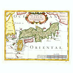
Les Isles du Iapon.
A very pleasant map of the island of Japan as seen in the mid-seventeenth century by the important and influential French cartographer, Nicolas Sanson. The map also shows...
Date: Paris, ca. 1652
Selling price: ????
Please login to see price!
Sold in 2019
L'Asie En Plusieurs Cartes Nouvelles. . .
Apparently an unknown variant, maybe a state between 1652 and 1662. The title-page bears the date of the first edition (1652), the address of the second edition (B) missp...
Date: Paris, l'Autheur, 1652
Selling price: ????
Please login to see price!
Sold in 2017
Lumen Historiarum per Occidentem. . . / Lumen Historiarum per Oreintem. . . Lumen Historiarum per Occidentem. . . / Lumen Historiarum per Orientem. . .
A pair of interesting seventeenth-century maps. The first map is an unusual 1652 map of Europe as known to the ancients by Jan Jansson. Centered on Italy, this map covers...
Date: Amsterdam, 1652
Selling price: ????
Please login to see price!
Sold in 2018
Germania Antiqua Australis...
A scarce map of central Europe with the ancient place names. Extends from modern day France until Poland, and from Denmark until Switzerland. Includes two decorative titl...
Date: Unknown, ca. 1652
Selling price: ????
Please login to see price!
Sold in 2018
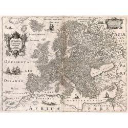
Europa exactissime descripta.
A fine map, embellished with two cartouches, several ships and a sea-monster, polar bears and lions. With French text on verso.
Date: Amsterdam, 1652
Selling price: ????
Please login to see price!
Sold in 2017
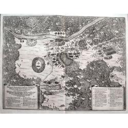
Delineatio Memorabilis Conflictus et Victoriae Lithuanorum Duce Radivilio de Cricevio et Triginta. . .
A fantastic illustration of the Battle of Loyew during the Khmelnytsky uprising in 1649. Near the site of the present-day town of Loyew in Belarus, a numerically superior...
Date: Frankfurt, ca 1652
Selling price: ????
Please login to see price!
Sold in 2018
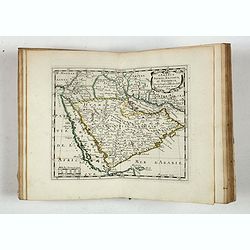
![[Rare map centered on the Arabian Peninsular and India reaching till Malysia.]](/uploads/cache/42886-250x250.jpg)
[Rare map centered on the Arabian Peninsular and India reaching till Malysia.]
Early map of the Indian Ocean region, from the Eastern Mediterranean (Alexandria) to Malaysia and Sumatra. Shows The passage of Nimrod and The passage of Ophir en Hauilah...
Date: London, John Saywell in 1652
Selling price: ????
Please login to see price!
Sold in 2025
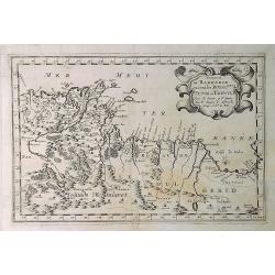
Partie de Barbarie ou Sont les Royaumes de Tunis et Tripoli. . .
A coastal map of Tunisia and Libya prepared by N.Sanson and published by Pierre Mariette. Published in an early edition of the small Sanson atlas L'Europe Dediée a Monse...
Date: Paris, 1652
Selling price: ????
Please login to see price!
Sold in 2019
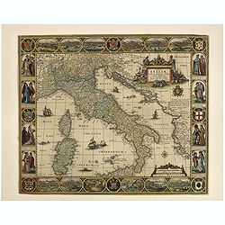
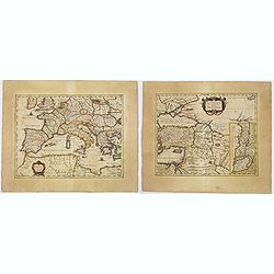
Tabula Italiae, Corsicae, Sardiniae et adjacentium Regnorum. A°1652.
This beautiful old colored engraved map is signed on plate by Nicolas Iohannis Visscher, and by the engraver Abraham Goos on lower left. The border is decorated with 12 v...
Date: Amsterdam, 1652
Selling price: ????
Please login to see price!
Sold in 2019
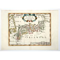
LES ISLES DU IAPON (Japan.)
A very pleasant map of the island of Japan as seen in the mid-seventeenth century by the important and influential French cartographer, Nicolas Sanson. The map also shows...
Date: Paris, ca 1652
Selling price: ????
Please login to see price!
Sold in 2019
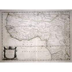
Carte De Nigritie Et Guinee.
Copper engraving map of Nigeria and Guinea, Western Africa, from Mauritania to Zaire. The map has an attractive water mark and a Decorative title cartouche. A highly deta...
Date: Paris, 1653
Selling price: ????
Please login to see price!
Sold in 2015
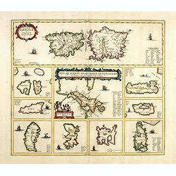
Insularum Sardiniae et Corsicae Antiqua descriptio/ Insular Aliquot Aegaei Maris Antiqua descrip.
Map showing Sardinia, Corsica and Aegean Islands including Chios, Rosi, Lemnos and Lesbos. From an historical atlas by Georgius Hornius,"Accuratissima orbis antiqui ...
Date: Amsterdam, 1653
Selling price: ????
Please login to see price!
Sold in 2014
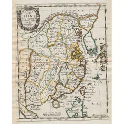
China Veteribus Sinarum Regio.
This was the first of Blaeu's maps of China. In 1655 he was to publish the famous map of Father Martini, with many of the earlier inaccuracies present on this map correct...
Date: Amsterdam, 1653
Selling price: ????
Please login to see price!
Sold in 2021
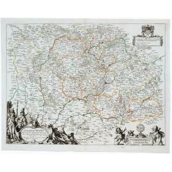
Diocese du Mans...
Published by Mariette en la Rue S. Iacques a l'Enseigne de l'Esperance. With a dedication of Mr. Christophle Justel Conseiller et Secretaire du Roy… Engraved by Michel ...
Date: Paris, 1653
Selling price: ????
Please login to see price!
Sold in 2017
China Veteribus Sinarum Regio.
This was the first of Blaeu's maps of China. In 1655 he was to publish the famous map of Father Martini, with many of the earlier inaccuracies present on this map correct...
Date: Amsterdam, 1653
Selling price: ????
Please login to see price!
Sold in 2016
Sarmatiae Europae ae delineatio.
Scarce map of Poland, Lithuania, Russia, with inset map of Crimea. (550x670mm.)From his "Parallela geographiae veteris et novae."
Date: Paris, 1653
Selling price: ????
Please login to see price!
Sold in 2015
Asia Recens Summa Cura Delineata
After the map by Hondius, from "Théâtre géographique". A rare separately issued map of Asia, by Pierre Mariette, based upon Hondius' map of Asia. The map has...
Date: Paris, 1653
Selling price: ????
Please login to see price!
Sold in 2016
Insularum Sardiniae et Corsicae Antiqua descriptio/ Insular Aliquot Aegaei Maris Antiqua descrip.
A striking map showing Sardinia, Corsica and many of the Aegean Islands, including Chios, Rosi, Lemnos and Lesbos.From an historical / geographical Atlas by Georgius Horn...
Date: Amsterdam, 1653
Selling price: ????
Please login to see price!
Sold in 2017
Les Etats de la couronne d'Arragon en Espagne..
"Fine map of Aragon, including Majorca, Minorca and Ibiza.This edition carries the date 1653.Nicolas Sanson was to bring about the rise of French cartography, althou...
Date: Paris 1653
Selling price: ????
Please login to see price!
Sold
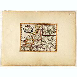
Armenia Vetus In Quatuor Partes..
Uncommon map of ancient Armenia.
Date: Paris 1653
Selling price: ????
Please login to see price!
Sold
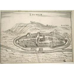
Lochem.
Nice bird's-eye view of the town of Lochem in central part of the province of Gelderland.Very detailed engraving, with the Lochemer berg in the background.Made by Nicolaa...
Date: Arnhem 1653
Selling price: ????
Please login to see price!
Sold
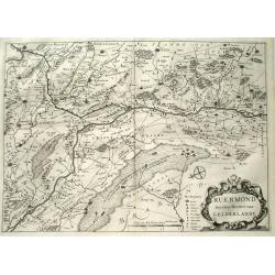
Ruermond, Het Over Vierdeel van Gelderlandt
Rare map of the southern part of the former duchy of Gelre, now a part of the Dutch province of Limburg. The map shows the area of Northern Limburg and the eastern part o...
Date: Arnhem 1653
Selling price: ????
Please login to see price!
Sold
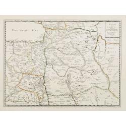
Armenia Vetus In Quatuor Partes..
Uncommon map of ancient Armenia.
Date: Paris, 1653
Selling price: ????
Please login to see price!
Sold in 2008
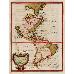
La division de Locean du Nouveau Monde.
California is shown as a large island with nearly flat northern coast with two place names, C.de Mondouno and C.S. Luc. Blank to the north.From "Parallela geographia...
Date: Paris, 1653
Selling price: ????
Please login to see price!
Sold in 2017
Theatre Geographiqiue de L'Europe. . .
Atlas illustrated with 57 double-page maps (of 60). Maps 24 (Bourgogne), 25 (Bresse) and 49 (Allemagne) are missing. The maps are numbered in ink in the upper right-hand ...
Date: Paris, 1653
Selling price: ????
Please login to see price!
Sold in 2019
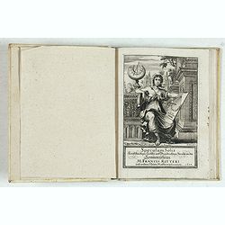
Speculum Solis künststandiger Leichter und Gründrichtiger Bericht
This beautiful engraving is a horological diagram with at bottom a 32-point wind rose and signed underneath "M:Franciscus Ritter N fac A° 1640".Remarkable for...
Date: Nuremberg 1653
Selling price: ????
Please login to see price!
Sold in 2023
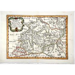
ROYAUME de MAROC divise en sept-Provinces &c.
A very fine, old color, decorative map of Morocco, first published by Nicholas Sanson in 1654. The map is based in part on the maps in the atlas of Livio Sanuto.
Date: Paris 1654
Selling price: ????
Please login to see price!
Sold in 2019
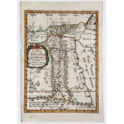
EGYPTE divisee en ses DOUZE CASSILIFS, ou GOUVERNEMENS.
A very fine, detailed map of Egypt, first issued by Nicolas Sanson in 1654. Extends from the Red Sea and Israel to the Nile River Valley.
Date: Paris 1654
Selling price: ????
Please login to see price!
Sold in 2019
Diocese du Mans Divisee Par Doyennes Ruraux ...
Detailed fine 1654 Nicolas Sanson & Pierre Mariette's copper engraved map of the area around Le Mans in France. The map is filled with excellent topographic detail on...
Date: Paris, 1654
Selling price: ????
Please login to see price!
Sold in 2023
Abbildung der 4. Waldtstätten See.
View of Lake Lucerne and the surrounding land. Detailed indications of all the places and castles present in the region. Representation of mountainous terrain.. Printed f...
Date: Frankfurt, 1654
Selling price: ????
Please login to see price!
Sold in 2021
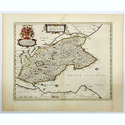
Fifae Vicecomitatus. The Sherifdome of Fyfe.
A decorative Scottish county map by Blaeu. It shows the whole Fife peninsula with Edinburgh at bottom of the map. Published in his Atlas Novus Vol. 5 in 1654, The map is ...
Date: Amsterdam, 1654
Selling price: ????
Please login to see price!
Sold in 2023
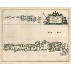
Vistus Insula, vulgo VII ST, cum aliis minoribus
This scarce map of Barra and North and South Uist in the Outer Hebrides of Scotland by Joan Blaeu was based on the surveys done by Timothy Pont some half-century earlier....
Date: Amsterdam, 1654
Selling price: ????
Please login to see price!
Sold in 2023
Partie meridionale de L'Inde En deux Presqu'Isles l'une deca et l'autre Gange
A superb example of Sanson's map of the Indian subcontinent and Southeast Asia. With the Dutch and English East India Companies being founded at the turn of the 17th maps...
Date: Paris, 1654
Selling price: ????
Please login to see price!
Sold in 2023
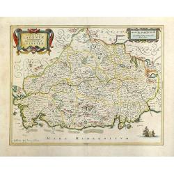
Lagenia; Anglis Leinster / The countie of Leinster.
An elegant map which includes the area westward from Dublin to the Shannon and from Waterford in the north to Drogheda. A decorative map with galleons in full sail in the...
Date: Amsterdam, 1654
Selling price: ????
Please login to see price!
Sold in 2018
Carte du Diocese de l'Evesche d'Eureux en Normandie . . .
Uncommon map of the French region Normandy with fine title cartouche upper left and dedication cartouche to Bishop Gilles Boutault, bishop of Evreux.River Seine in upper ...
Date: Paris, 1654
Selling price: ????
Please login to see price!
Sold
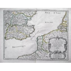
Anciens Royaumes de Kent, d'Essex, et de Sussex: ou sont Aujourdhuy les Comtés de Kent, d'Essex, Middlessex, et Hartford de Sussex, et Surrey. Avecq le Pas de Calais, et Partie des Cotes du Pays Bas, de Picardie, et Normandie.
Interesting map of the Strait of Dover / Pas de Calais. Shows the French coast from Fecamp, Dieppe, Boulogne, Calais; the Belgian Coast with Oostende, and the Dutch Coast...
Date: Paris, 1654
Selling price: ????
Please login to see price!
Sold in 2012
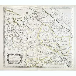
Sarmatia Utraque Europaea et Asiatica. . .
The ancient map of the European part of Russia with the Ukraine. Dated 1654.Nicolas Sanson was to bring about the rise of French cartography, although the fierce competit...
Date: Paris, 1654
Selling price: ????
Please login to see price!
Sold in 2014
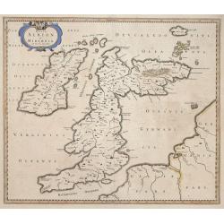
Insulae Albion et Hibernia cum minoribus adjacentibus.
This map of the British Isles during ancient times is based on the cartography of Mercator’s Ptolemaic presentation of the British Isles and Ireland, The map delineates...
Date: Amsterdam, 1654
Selling price: ????
Please login to see price!
Sold in 2014
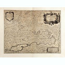
Moscoviae pars australis...
Fine example of this early map of the southern part of Russia, showing the region centered on Moscow. Prepared by Isaac Massa, a Dutch map-maker who travelled to Russia, ...
Date: Amsterdam, ca. 1654
Selling price: ????
Please login to see price!
Sold in 2015