Browse Listings
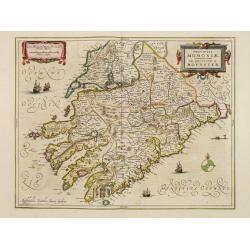
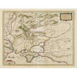
Provincia Momoniae. The province of Mounster.
Fine map of southern part of Ireland. Adorned with vessels, sea monsters, a compass rose and two very decorative cartouches.
Date: Amsterdam 1645
Selling price: ????
Please login to see price!
Sold
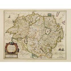
Provincia Ultoniae. The province of Ulster.
Finely engraved map of Ulster. Adorned with vessels and a decorative title cartouche. Relief shown pictorially. Illustrated topography shows towns, river systems and indi...
Date: Amsterdam 1645
Selling price: ????
Please login to see price!
Sold
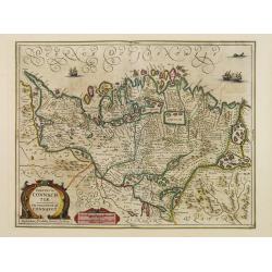
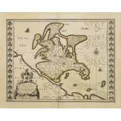
Provincia Connachtiae. The province of Connaught.
Finely engraved map of the north-western part of Ireland. Adorned with vessels, sea monsters and two very decorative cartouches. Relief shown pictorially. Illustrated top...
Date: Amsterdam 1645
Selling price: ????
Please login to see price!
Sold
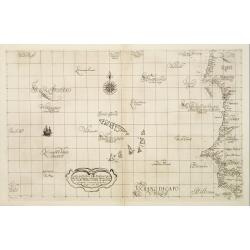
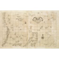
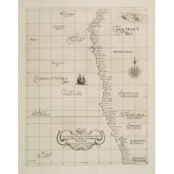
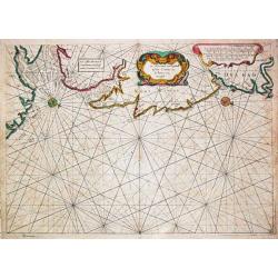
Carta Particolare della Barberia Australe che comincia con il capo Matas è Finiscie con ilc Himilas con l'Isole di capo Verde.
First state of Dudley?s magnificent chart showing the west coast of Africa including the Cape Verde Islands. Include a sailing ship, notes on prevailing winds and current...
Date: Florence 1645
Selling price: ????
Please login to see price!
Sold
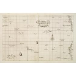
Carta Particolare della parte Tramontana dell Isola di San Lorenzo con la costa diripetto sino à Monbazza con l'Isole è Seccagne int.. Carta XIII I.
First state of Dudley?s magnificent chart showing the east coast of Africa including the northern half of Madagascar. Include a sailing ship, compass card, notes on preva...
Date: Florence 1645
Selling price: ????
Please login to see price!
Sold
Carta Particolare del mare di Etthiopia con l'Idola di S:Elena è parte della Costa .. Carta VIIII.
First state of Dudley's magnificent showing the west coast of Africa. Include sailing ships, compass card, notes on prevailing winds and currents and more stylized calli...
Date: Florence, 1645
Selling price: ????
Please login to see price!
Sold in 2008
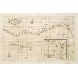
Carta Particolare che commincia con il fiu me Iuntas nella Guinea è finisce con il capo di S.Dara è con l'Isola d'S:Thmaso. . Carta VI.
First state of Dudley?s magnificent chart showing the coast of New Guinea. Include a sailing ship, compass card, notes on prevailing winds and currents and more stylized ...
Date: Florence 1645
Selling price: ????
Please login to see price!
Sold
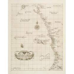
Carta Particolare che comincia con l'Isola di S:Tomaso o Tome è d S. Clara è finisce con il c: d' Aldeas .. Carta VII.
Dudley?s magnificent chart shows the Gulf of Guinea with the Island São Tomé. One of the smaller scale, more specific (?Carta Particolare?) maps and include sailing shi...
Date: Florence 1645
Selling price: ????
Please login to see price!
Sold
Carta Particolare che comincia con l'Isola di S:Tomaso o Tome è d S. Clara è finisce con il c: d' Aldeas .. Carta VII.
Dudley?s magnificent chart shows the Gulf of Guinea. One of the smaller scale, more specific (?Carta Particolare?) maps and include sailing ships, notes on prevailing win...
Date: Florence 1645
Selling price: ????
Please login to see price!
Sold
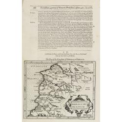
Marocchi Regnum.
Samuel Purchas' edition of the Mercator/Hondius "Atlas Minor". Early map of Morocco published in his famous collection of voyages "His Pilgrimes". Wit...
Date: London, 1645
Selling price: ????
Please login to see price!
Sold in 2020
Aegyptus.
Samuel Purchas' edition of the Mercator/Hondius "Atlas Minor". Early map of the Nile delta with swash lettering and title cartouche with strapwork surrounds, pu...
Date: London 1645
Selling price: ????
Please login to see price!
Sold in 2011
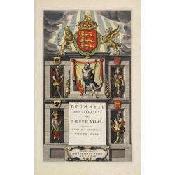
Title page from "Toonneel des Aerdeycx, oft Nieuwe atlas..".
Attractive title page of Blaeu's Atlas of England and Wales. Very decorative, and finely engraved architectural façade, with figures of a Briton, Roman, Saxon, Dane and ...
Date: Amsterdam 1645
Selling price: ????
Please login to see price!
Sold
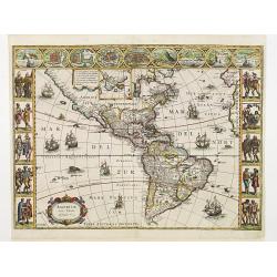
Americae Nova Tabula.
One of the best known and sought after seventeenth century maps of America. Blaeu's famous carte a figure map of America is regarded as a high point in Dutch cartography....
Date: Amsterdam, 1645
Selling price: ????
Please login to see price!
Sold
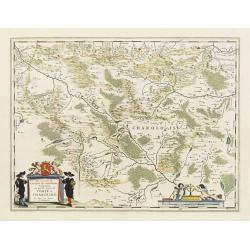
Les environs de L'Estang de Longpendu,.. Charolois.
A very decorative map with beautiful cartouches of Charolois in the Bourgogne by one of the most famous map publishers.
Date: Amsterdam, 1645
Selling price: ????
Please login to see price!
Sold in 2017
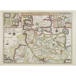
Ducatus Holsatiae nova tabula.
Beautiful map of Schleswich Holstein covering the region from Hussum till Hamburg, with numerous place-names of cities, towns, villages, forests and castles.With two inse...
Date: Amsterdam, 1645
Selling price: ????
Please login to see price!
Sold in 2017
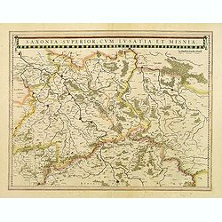
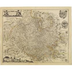
Saxonia superior, cum Lusatia et Misnia.
Detailed map of Saxen, Meissen and Dresden in the middle of the map.
Date: Amsterdam, 1645
Selling price: ????
Please login to see price!
Sold in 2021
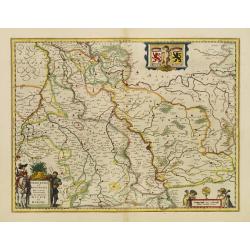
Comitatus Bentheim et Steinfurt.
Text on verso. An excellent and early map of Bentheim and Steinfurt in Germany. Very decorative title cartouche surrounded by two coats of arms. The scale cartouche is em...
Date: Amsterdam, 1645
Selling price: ????
Please login to see price!
Sold in 2013
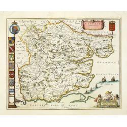
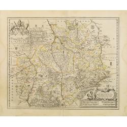
Essexia Comitatus.
Double-page attractive map of the country of Essex. Showing London in the lower left corner, and other towns such as West Ham, East Ham, Waltham stow, South end on Sea, H...
Date: Amsterdam, 1645
Selling price: ????
Please login to see price!
Sold in 2011
Iuliacensis et Montensis Ducatus. De Hertoghdomen Gulick en Berghe.
Finely engraved map depicts the Duchies of Jülich and Berg on the Rhine River.It is richly embellished with cartouches, figures and coats of arms.
Date: Amsterdam 1645
Selling price: ????
Please login to see price!
Sold
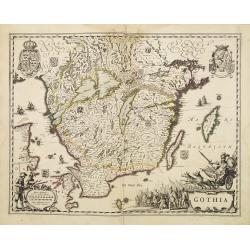
Gothia.
Very decorative map of the southern part of Sweden. The forested topography and lakes are well depicted.The main feature of the engraving is the large title cartouche sur...
Date: Amsterdam 1645
Selling price: ????
Please login to see price!
Sold
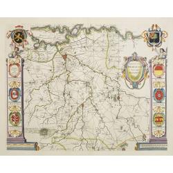
Palatinatus ad rhenum.
Detailed map of a province of Germany by one of the most famous map publisher.Covering southern part of the river Rhine. Including the towns of Frankfurt, Heidelberg.Uppe...
Date: Amsterdam 1645
Selling price: ????
Please login to see price!
Sold
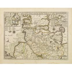
Ducatus Holsatiae nova tabula.
Finely engraved map centered on the area north of Hamburg and Lubeck with two insets.This is a second state of a map initially made by Jodocus Hondius.
Date: Amsterdam 1645
Selling price: ????
Please login to see price!
Sold
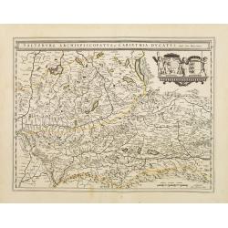
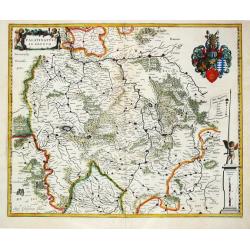
Saltzburg Archiepiscopatus, et Carinthia Ducatus
Handsome map of the archbishopry of Salzburg and the Duchy of Carinthia.Title in banner form with two coats of arms and three cherubs decorating the map.
Date: Amsterdam 1645
Selling price: ????
Please login to see price!
Sold
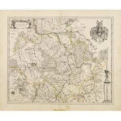
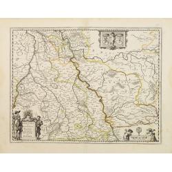
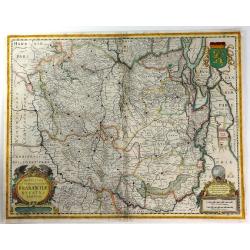
Alsatia Landgraviatus cum Suntgoia et Brisgoia
Large map of Alsace based on the work of Gerard Mercator. Covers the region including the Rhine from Granville to Sarburg in the north and from Basel to Landaw in the sou...
Date: Amsterdam 1645
Selling price: ????
Please login to see price!
Sold
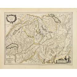
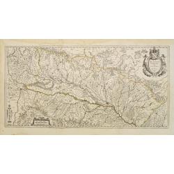
Helvetia cum finitimis regionibus confoederatis.
Detailed map of Switzerland, based on Gerard Mercator's map of the same title.Densely engraved to illustrate the mountainous topography with information including even th...
Date: Amsterdam 1645
Selling price: ????
Please login to see price!
Sold
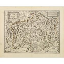
Argow cum parte merid. Zurichgow.
Nice map of Canton Aargau and parts of the Cantons Schwyz, Zurich and Glarus. Includes the cities of Bern and Lucern.Based on the cartography of Gerard Mercator and very ...
Date: Amsterdam 1645
Selling price: ????
Please login to see price!
Sold
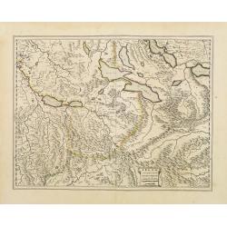
Alpinae seu Foederatae Rhaetiae subditarumque..
Detailed map Graubünden Canton in Switzerland. Including Chur, Davos, St.Moritz, etc. Engraved by Simon Hamersveldt.Originally engraved for Jodocus Hondius, at his death...
Date: Amsterdam 1645
Selling price: ????
Please login to see price!
Sold
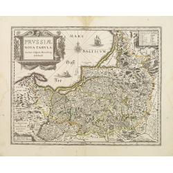
Prussiae nova tabula.
As indicated in the title cartouche, the map was prepared by the German cartographer Gaspher Henneberg of Erlich.
Date: Amsterdam 1645
Selling price: ????
Please login to see price!
Sold
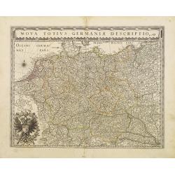
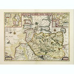
Nova Totius Germaniae Descriptio.
As indication in the title cartouche, the map was prepared by the German cartographer Gaspar Henneberg of Erlich.
Date: Amsterdam 1645
Selling price: ????
Please login to see price!
Sold
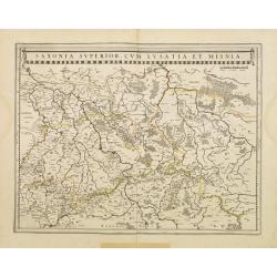
Saxonia Superior, cum Lusatia et Misnia.
Finely engraved and detailed map of Saxony including Halle, Leipzig, Meissen, and Dresden. Filled with forests and tiny villages. It presents Prague close to the center o...
Date: Amsterdam, 1645
Selling price: ????
Please login to see price!
Sold in 2011
Rugia Insula ac ducatus..
Willem Blaeu's highly decorative map of the island of Rugen. Embellished with a title-cartouches, and 30 coats-of-arms in the borders. From the Latin edition of Willem Bl...
Date: Amsterdam 1645
Selling price: ????
Please login to see price!
Sold
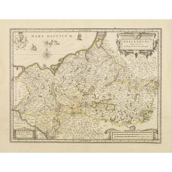
Meklenburg Ducatus.
Finely engraved map with a very decorative title cartouche adorned with a chain of fruits. A ship is sailing on the Baltic near a wind rose. In the left-hand upper part, ...
Date: Amsterdam 1645
Selling price: ????
Please login to see price!
Sold
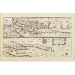
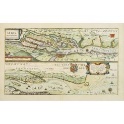
Celeberrimi Fluvis Albis nova delineatio.
Beautiful map of the river Elbe and Hamburg. Latin text on verso.Originally engraved for Jodocus Hondius, at his death on August 18, 1629, this among 39 other Hondius cop...
Date: Amsterdam 1645
Selling price: ????
Please login to see price!
Sold
Episcopatus Hildesiensis descriptio novissima..
A fine and attractive mid-17th century folio sheet copper engraved map of the region around Hildesheim, in Lower Saxony. Includes numerous cities and corresponding coat o...
Date: Amsterdam 1645
Selling price: ????
Please login to see price!
Sold
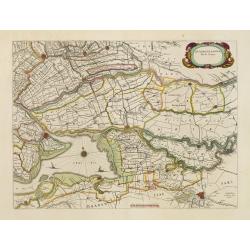
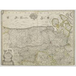
Circulus Westphalicus sive Germaniae Inferioris.
West to the top. Detailed map of the northern part of Germany far south to Düsseldorf, Waldeck and Paderborn.Lower right imposing title cartouche with inset map of Hambu...
Date: Amsterdam 1645
Selling price: ????
Please login to see price!
Sold
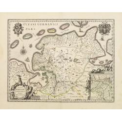
Typus Frisiae Orientalis.
Decorative map of east Frisia in Germany with the Watten islands. With inset map of the area south of Emden.Prepared by Ubbo Emmius (1547-1625).
Date: Amsterdam 1645
Selling price: ????
Please login to see price!
Sold
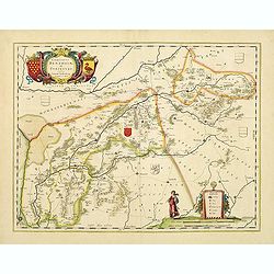
Juliacensis et Montensis Ducatus/ De Hertoghdomen Gulick..
Map of the area to both sides of the Rhine between Bonn and Wesel, centred on Düsseldorf and reaching to Maastricht in the west and Altena/Westfalen in the east.Decorati...
Date: Amsterdam 1645
Selling price: ????
Please login to see price!
Sold

Franconia vulgo Franckenlandt.
Wide margins centered on Bamberg, Nuremberg, Wurzburg, and Nuremberg. Latin text on verso.With scale of longitude and latitude, and decorative cartouches.
Date: Amsterdam 1645
Selling price: ????
Please login to see price!
Sold
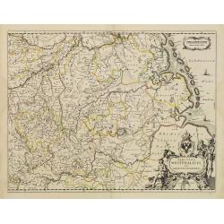
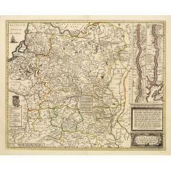
Hassia Landgraviatus.
Centered on the town of Kassel. With decorative title cartouche. Latin text on verso.With scale of longitude and latitude, and decorative cartouches.
Date: Amsterdam 1645
Selling price: ????
Please login to see price!
Sold
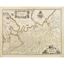
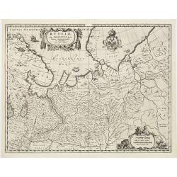
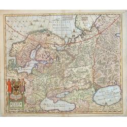
Russiae vulgo Moscovia dictae, Partes Septentionalis et Orientalis.
Covers the northern part of Russia from Finland to just beyond the Jenisej River and south to the Volga River. Includes the cities of Jaroslavl, Niznij Novgorod, and Kaza...
Date: Amsterdam 1645
Selling price: ????
Please login to see price!
Sold
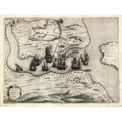
Áfbeeldinge vande Cabo St. Augustin Met haer forten.
The taking of the Portuguese settlement at Cape St. Augustin by a Dutch fleet. From I. Commelin's work on the history of the Dutch in Brasil.
Date: Amsterdam, c. 1645
Selling price: ????
Please login to see price!
Sold
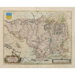
Zuydhollandia stricte sumta.
The countship of Holland was subdivided into a number of bailiwicks. The most southerly bailiwick, bordering on Brabant was named Zuid-Holland. Many floods changed the ap...
Date: Amsterdam 1645
Selling price: ????
Please login to see price!
Sold in 2019
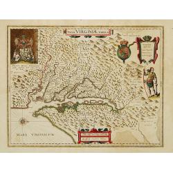
Nova Virginiae Tabula.
The map is based on the first state of Smith's map, 1612, and is slightly larger and more expertly engraved. In 1629 the Hondius plate was purchased by Blaeu who deleted ...
Date: Amsterdam 1645
Selling price: ????
Please login to see price!
Sold
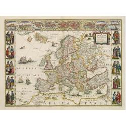
Europa recens descripta à Guilielmo Blaeuw.
On either side columns depicting the manner of dress in the major countries of Europe, surmounted by nine city views and plans.For European mapmakers their own continent ...
Date: Amsterdam 1645
Selling price: ????
Please login to see price!
Sold
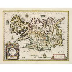
Tabula Islandiae..
This handsome map of Iceland was based on information from a Dutch navigator named Joris Carolus in about 1620. The map shows the influence of both versions of bishop Gud...
Date: Amsterdam 1645
Selling price: ????
Please login to see price!
Sold
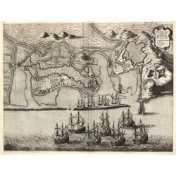
t' Neemen van de Suyker Prysen in de Bay de Tode los Santos Anno 1627.
Nice copper engraving of the Dutch fleet under command of Piet Heyn capturing the fort at the entrance to the Baia de Todos os Santos, in northeastern Brazil. Large inset...
Date: Amsterdam, c. 1645
Selling price: ????
Please login to see price!
Sold
Magni Ducatus Lithuaniae..
Highly detailed map of Poland and part of Russia up to the River Dnepr. No text on the verso.Sailing ship, cartouche and coat of arms, plus an elaborate mounted battle sc...
Date: Amsterdam 1645
Selling price: ????
Please login to see price!
Sold
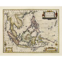
Indiae Orientalis nova descriptio.
An important map of South East Asia, noteworthy for being amongst the first maps to include any information on the discoveries made by the Dutch vessel Duyfkens in New Gu...
Date: Amsterdam 1645
Selling price: ????
Please login to see price!
Sold
Russiae vulgo Moscovia dictae, Partes Septentionalis et Orientalis.
Covers the northern part of Russia from Finland to just beyond the Jenisej River and south to the Volga River. Includes the cities of Jaroslavl, Niznij Novgorod, and Kaza...
Date: Amsterdam 1645
Selling price: ????
Please login to see price!
Sold

Tabula Russiae.
A re-issue, by Willem Blaeu, of Hessel Gerritsz' rare and influential map of Russia.This fine map was compiled from manuscripts brought back from Russia, by Isaac Massa t...
Date: Amsterdam, 1645
Selling price: ????
Please login to see price!
Sold
Taurica Chersonesus,..Prezecopsca, et Gazara..
Part of Russia with in the north Smolensk and Moscow and in the south the Black Sea.
Date: Amsterdam, 1645
Selling price: ????
Please login to see price!
Sold
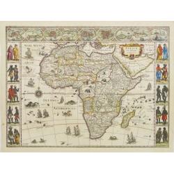
Africae nova descriptio.
Much of the geographical information is still based on the Ptolemaic maps, with the Nile shown with its source in the Lakes Zaire and Zaflan. Also included are various ot...
Date: Amsterdam, 1645
Selling price: ????
Please login to see price!
Sold

Nova Totius Germaniae Descriptio.
As indication in the title cartouche, the map was prepared by the German cartographer Gaspher Henneberg of Erlich. Showing central Europe, including the Netherlands, Belg...
Date: Amsterdam, 1645
Selling price: ????
Please login to see price!
Sold
De Noort Cust van Engelandt / tusschen Crammer en / de Revier van / Nicastle. 12
Father Jacob (1600-73) and son Arnold Colom (1624-68) were highly successful publishers of nautical charts. ' Vyerige Colom', in Dutch, French and English editions, sea-a...
Date: Amsterdam, 1645
Selling price: ????
Please login to see price!
Sold in 2011
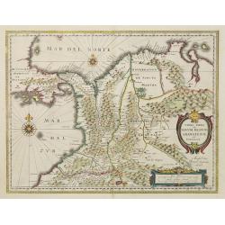
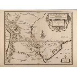
Terra Firma et Novum regnum Granatense et Propayan.
Fine copy, with wide margins of this handsome map of the Isthmus of Panama and northwestern South America including most of present day Columbia and part of Venezuela. Te...
Date: Amsterdam, 1645
Selling price: ????
Please login to see price!
Sold in 2008
Celeberrimi Fluvis Albis nova delineatio.
Beautiful map of the river Elbe and Hamburg. Latin text on verso.Originally engraved for Jodocus Hondius, at his death on August 18, 1629, this among 39 other Hondius cop...
Date: Amsterdam, 1645
Selling price: ????
Please login to see price!
Sold in 2020
Ducatus Holsatiae nova tabula.
Finely engraved map centered on the area north of Hamburg and Lubeck with two insets.This is a second state of a map initially made by Jodocus Hondius.
Date: Amsterdam, 1645
Selling price: ????
Please login to see price!
Sold in 2019
Novissima et Accuratissima Brabantiae Ducatus Tabula.
A fine map of The Netherlands that encloses the area between the rivers Rhine, Maas and Schelde, with Namur as the most southern town. North is shown to the right.On the ...
Date: Amsterdam, 1645
Selling price: ????
Please login to see price!
Sold in 2016
Quarta pars Brabantiae cujus caput Sylvaducis.
A good and dark impression in strong original colors.The third state. The coat of arms of Brabant and 's-Hertogenbosch appears on the map. The municipal arms in the colum...
Date: Amsterdam, 1645
Selling price: ????
Please login to see price!
Sold in 2008
Palatinatus ad Rhenum.
Willem Blaeu, founder of the famous publishing firm. Originally publishing pilot-guides, he issued his first atlas, 'Atlantis Appendix', in 1630, followed by his "Th...
Date: Amsterdam, 1645
Selling price: ????
Please login to see price!
Sold in 2019
Lusatia Superior . . .
Attractive map of the region straddling present-day southwestern Poland, Saxony and the Czech Republic.Old city names including Lieba, Gorlitz, Dresden, Pirnaw, and Prybu...
Date: Amsterdam, ca. 1645
Selling price: ????
Please login to see price!
Sold in 2015
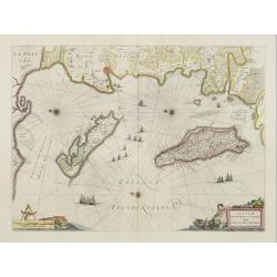
Insulae divi Martini et Uliarus, Vulgo l' Isle de Ré et Oléron.
Map of Ré and Oléron islands. Depicting the west coast of France, showing La Rochelle. Several vessels and sailing ships dot the Atlantic ocean.Three wind roses indicat...
Date: Amsterdam, 1645
Selling price: ????
Please login to see price!
Sold in 2015
Novissima Russiae Tabula.
Detailed map of Russia including Scandinavia. Bottom left title cartouche and dedication. Prepared by Isaac Massa.
Date: Amsterdam, 1645
Selling price: ????
Please login to see price!
Sold in 2013
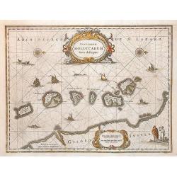
Insularum Moluccarum Nova descriptio - Amstelodami, Apud Ioannem Ianßonium.
Shows the islands Moluccas of Indonesia. Very decorative map.
Date: Amsterdam, 1645
Selling price: ????
Please login to see price!
Sold in 2013
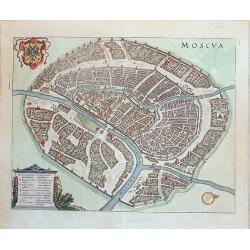
Moscva
Bird's-eye plan of Moscow situated at the junction of the Moskva and Neglinnaya Rivers. The map shows the Kremlin and old city, Kitay-gorod, in the center, surrounded by ...
Date: Frankfurt, ca. 1645
Selling price: ????
Please login to see price!
Sold in 2013
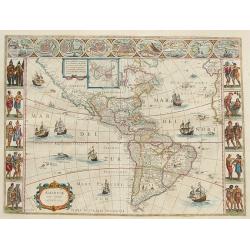
Americae Nova Tabula.
Blaeu's America, with extensive gold highlights. Blaeu's famous map of America is flanked by panels on three sides. People of Virginia, Florida, California, and South Am...
Date: Amsterdam, ca. 1645
Selling price: ????
Please login to see price!
Sold in 2008
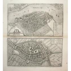
Dordracum (Dordrecht) and Briela (Briele)
Nice city plan of Dordrecht and Brielle, detailed with buildings houses, walls and gardens.
Date: Frankfurt, ca. 1645
Selling price: ????
Please login to see price!
Sold in 2008
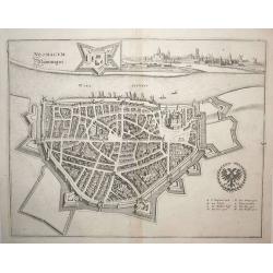
Neomagum (Nijmegen)
Nice city plan of Nijmegen at the Waal river. Detailed with buildings houses, walls and gardens and a view of the city in the right upper corner.
Date: Frankfurt, ca. 1645
Selling price: ????
Please login to see price!
Sold in 2008
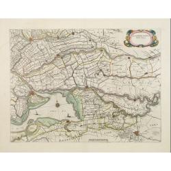
Zuydhollandia stricte sumta.
The count ship of Holland was subdivided into a number of bailiwicks. The most southerly bailiwick, bordering on Brabant was named Zuid-Holland. Many floods changed the a...
Date: Amsterdam, 1645
Selling price: ????
Please login to see price!
Sold in 2008
Paraguay, o Prov. de Rio de la Plata cum regionibus adiacentibus Tucuman et S.ta Cruz de la Sierra
Attractive map of Paraguay. With 2 cartouche and a sea monster.
Date: Amsterdam, 1645
Selling price: ????
Please login to see price!
Sold in 2009

Regnorum Hispaniae nova descriptio.
A fine copy of this impressive map of the whole Iberian Peninsula. Decorated with the Spanish Royal Coat of Arms. With Dutch text on verso.
Date: Amsterdam, 1645
Selling price: ????
Please login to see price!
Sold in 2010
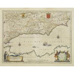
Granata et Murcia Regna.
A fine copy decorated with the Arms of both States and the figure of a surveyor. Extending from the Straits of Gibraltar to Alicante as far inland as the Guadalquivir val...
Date: Amsterdam, 1645
Selling price: ????
Please login to see price!
Sold in 2013
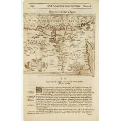
Barbaria / Egypt / Tunesia.
An illustrated page with three maps describing the coastal region in Northern Africa extending from Egypt to the Atlantic Ocean.The lower right map is of the Nile delta.T...
Date: London, 1645
Selling price: ????
Please login to see price!
Sold in 2020
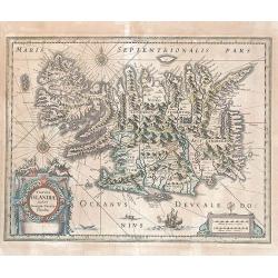
Tabula Islandiae.
Based on information from Joris Carolus collected around 1620. Huge mountains and volcanoes in a labyrinth of fiords. It is embellished by title and distance cartouches, ...
Date: Amsterdam, 1645
Selling price: ????
Please login to see price!
Sold in 2017
Comitatus Flandriae Nova Tabula.
Map of Flanders prepared by Henricus Hondius, the famous mapmaker.A beautiful ornamental title cartouche located on the lower left corner. Dedicated to Dr. Ionni d'Hondt.
Date: Amsterdam, 1645
Selling price: ????
Please login to see price!
Sold in 2009
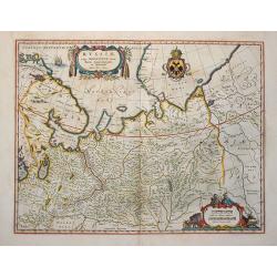
Russiae vulgo Moscovia dictae, Partes Septentionalis et Orientalis.
Covers the northern part of Russia from Finland to just beyond the Jenisej River and south to the Volga River. Includes the cities of Jaroslavl, Niznij Novgorod, and Kaza...
Date: Amsterdam, 1645
Selling price: ????
Please login to see price!
Sold in 2009
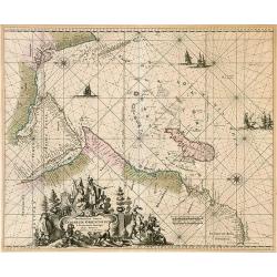
Occidentalior Tractus Indiarum Orientalium à Promotorio Bonae Spei ad C. Comorin.
Rare sea chart by Ottens of showing the coastlines of the Arabian peninsula and Africa up to Cape Town, with a splendid cartouche of royal figures and animals.
Date: Amsterdam, 1645
Selling price: ????
Please login to see price!
Sold in 2009
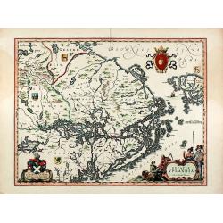
Ducatus Uplandia. Joh. et Cornelius Blaeu exc
Original old colored map of central Sweden showing the area around Stockholm. With a Swedish coat of arms, a figural cartouche with rural people and a knight in amour, a ...
Date: Amsterdam, 1645
Selling price: ????
Please login to see price!
Sold in 2009
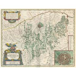
Territorio Norimbergense.
Decorative map with inset cityplan of Nurnberg. Latin text on verso.
Date: Amsterdam, c. 1645
Selling price: ????
Please login to see price!
Sold in 2010
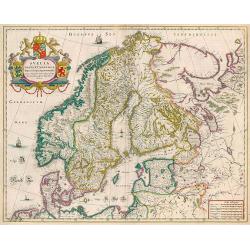
Suecia, Dania et Norvegia, Regna Europae Septentrionalia.
Decorative map of Scandinavia. Latin text on verso.
Date: Amsterdam, 1644-1645
Selling price: ????
Please login to see price!
Sold in 2010