Search Listings matching "cyprus"
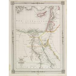
Égypte Palestine et Phénicie.
Detailed map of Egypt, Cyprus and the Holy Land, prepared by Auguste Henri Dufour (1798-1865). Published by Basset, rue de Seine 33, Paris. The engraver of the map was Ch...
Date: Paris 1846
Selling price: ????
Please login to see price!
Sold
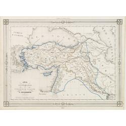
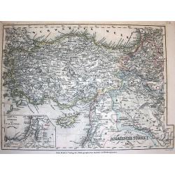
Asie Ottomane ou Turquie d'Asie..
Decorative map of Turkey and Cyprus, prepared by J.G.Barbié du Bocage.Engraved by Ch.Smith, published by Basset who was established in Paris, rue de Seine 33. From atlas...
Date: Paris, 1846
Selling price: ????
Please login to see price!
Sold in 2009
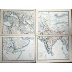
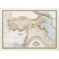
Map of the Countries lying between Turkey & Birmah, comprising Asia Minor, Persia, India, Egypt & Arabia, and including the Black, Caspian & Red seas by James Wyld, Geographer to the Queen, Charing Cross East. Model of the Earth, Leicester Square, London.
Map of the Countries lying between Turkey & Birmah, comprising Asia Minor, Persia, India, Egypt & Arabia, and including the Black, Caspian & Red seas by James...
Date: London, 1855
Selling price: ????
Please login to see price!
Sold in 2013
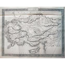
Asia Minor.
Very detailed and up-to-date map of Turkey including Cyprus. With numerous place names, roads connecting the towns, rivers, mountains, and regions. This is the uncommon ...
Date: London, c1855
Selling price: ????
Please login to see price!
Sold in 2013
Cyprus Insula ad Stadiasmum Maris Magni S. 297-317
Delicate map of ancient Crete according to the "Stadiasmus Maris Magni", prepared by Karl Wilhelm Ludwig Muller (1813-1894) and published in "Geographi Gra...
Date: Paris, Ambrosio Firmin Didot, 1855
Selling price: ????
Please login to see price!
Sold in 2017
Die Asiatische Türkey 1854.
A superbly steel-engraved map from the rare German Atlas: Meyer's Zeitungs-Atlas, considered to be the finest German Atlas of the mid 19th century! Revised edition for th...
Date: Hildburghausen, 1857
Selling price: ????
Please login to see price!
Sold
Turquie D'Asie Syrie, Liban. Region du Caucase.
Very detailed map from Atlas Sphérodïdal & Universel de géographie , Prepared by F.A.Garnier and edited by Jules Renouard, rue de Tournon, Paris. Uncommon map with...
Date: Paris, 1861
Selling price: ????
Please login to see price!
Sold in 2008
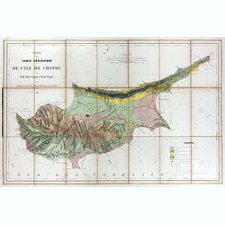
Essai d'une carte géologique de l'Ile de Chypre.
Geological map of Cyprus prepared by Albert Gaudry (1827-1908), professor at Muséum d'histoire naturelle and member of the London Royal society of Sciences.A color key i...
Date: Paris, 1862
Selling price: ????
Please login to see price!
Sold in 2017
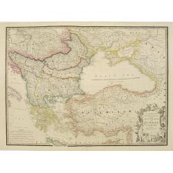
European Dominions of the Ottomans or Turkey in Europe..
Very detailed map of Turkey, Greece and the Black Sea. Northern part of Cyprus is included. Railways indicated.James Wyld (the younger) was geographer to the Queen and H....
Date: London, 1855/1864
Selling price: ????
Please login to see price!
Sold in 2009
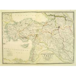
Map of the Ottoman Dominions in Asia. . .
Very detailed map of Turkey, Palestine, Azerbijan, Kurdistan, Georgia and Cyprus.James Wyld (the younger) was geographer to the Queen and H.R.H. Prince Albert. Joined his...
Date: London, 1855/1864
Selling price: ????
Please login to see price!
Sold in 2009
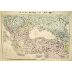
Carte du théatre de la guerre.
Very detailed map centered on the Black Sea and Cremea, including Turkey, Greece, Cyprus, etc. The map is hand colored according to the color key in the lower left. Uncom...
Date: Paris, ca. 1877
Selling price: ????
Please login to see price!
Sold in 2010
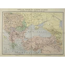
Carte du Théatre de la Guerre en Orient supplement au journal Le Temps du 30 avril 1877.
Map of the 1877 Russo-Turkish war. Drawn and engraved by R. Hausermann, 27 Rue St Andre des Arts Paris.The Russo-Turkish War of 1877-1878 had its origins in a rise in nat...
Date: Paris, after 1877
Selling price: ????
Please login to see price!
Sold in 2009
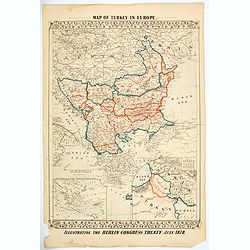
Map of Turkey in Europe. Illustrating the Berlin CongressTtreaty, July 1878.
An unusual map of Turkey, Greece, the Balkans, Austria and a part of the Ukraine, illustrating the nations created under the Berlin Congress Treaty, as well as the lands ...
Date: Philadelphia, 1878
Selling price: ????
Please login to see price!
Sold in 2021
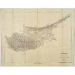
Cyprus. / London Atlas map of Cyprus.
With decorative cover title: LONDON ATLAS MAP OF CYPRUS. LONDON EDWARD STANFORD Ltd. Cartographer to the King, / 12, 13 & 14, LONG ACRE, W.C. and 29 & 30 Charing ...
Date: London, 1887
Selling price: ????
Please login to see price!
Sold in 2009
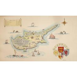
A Pictorial Map of Cyprus.
An attractive hand painted map of Cyprus a scroll cartouche has the Historical dates of the Islands occupation, the map centers on Nicosia. The sea has galleons, sea mons...
Date: ca. 1950
Selling price: ????
Please login to see price!
Sold in 2014
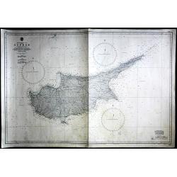
Cyprus
Large Admiralty sea chart of Cyprus.
Date: London, 1964
Selling price: ????
Please login to see price!
Sold in 2017
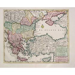
Nieuwe Kaart van Europisch Turkyen.
Izaak Tirion (d.1769) Amsterdam publisher. His Nieuwe en beknopte handatlas saw 6 editions between before 1740 and after 1784. Also Tegenwoordige staat van alle volkeren,...
Date: Amsterdam, 1733.
Selling price: ????
Please login to see price!
Sold
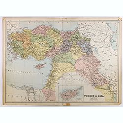
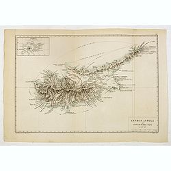
Turkey in Asia.
Very detailed map of Turkey. Inset of Cyprus. The map was printed from lithographic stones taken from a hand-engraved steel plate. The cartographer John Bartholomew of Ed...
Date: Edinburg
Selling price: ????
Please login to see price!
Sold in 2017