Search Listings matching "cyprus"
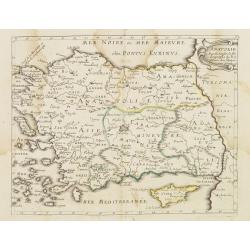
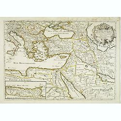
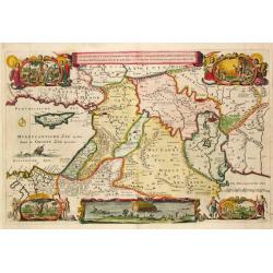
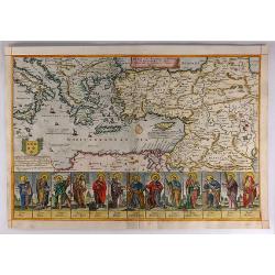
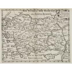
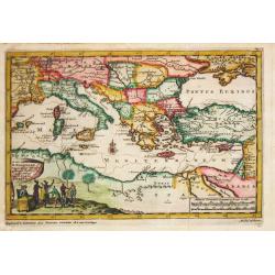
Mer Noire ou Mer Maievre . . .
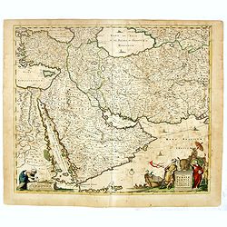
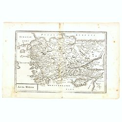
Map encompassing part of the Near East and the area comprehended between the Black Sea and the Caspian Sea. Centered on Turkey and Cyprus prepared by N.Sanson and publish...
Date: Paris, P. Mariette, 1667
Selling price: ????
Please login to see price!
Sold in 2011
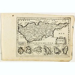
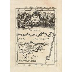
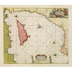
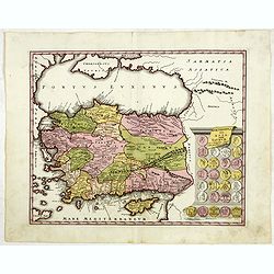
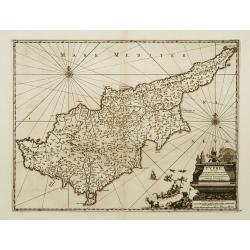
Cypre.
Rare map of Cyprus with decorative title cartouche. Below six small inset maps of Greek islands at bottom of page published by Jollain in 1667. Published in "Trésor...
Date: Paris, 1667
Selling price: ????
Please login to see price!
Sold in 2018
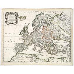
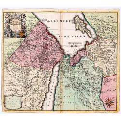
Europa Vetus.
Attractive historical map of Europe, the Mediterranean, and northern Africa. Extends to Cyprus and the Holy Land. Based on the cartography of Guillaume Samson and publish...
Date: Paris, 1668
Selling price: ????
Please login to see price!
Sold in 2013
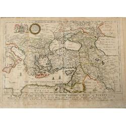
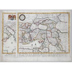
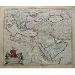
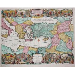
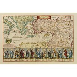
A MAPP of THE ESTATES of the TURKISH EMPIRE in ASIA, and EUROPE.
Uncommon antique map of the Eastern Mediterranean, Italy, Sicily, Cyprus, Turkey, the Black Sea & Caucasus, the Holy Land and Iraq, published in Blome's 'A Geographic...
Date: London, 1669
Selling price: ????
Please login to see price!
Sold in 2014
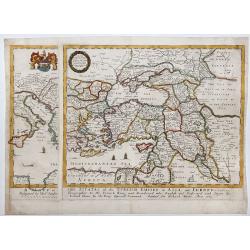
A MAPP of THE ESTATES of the TURKISH EMPIRE in ASIA, and EUROPE, 1669
A rare map of Turkey, Asia Minor, Cyprus, North Africa, Crimea, Southern part of Italy and Eastern Europe . This rare example is the earliest folio sized map of the regio...
Date: London, 1669
Selling price: ????
Please login to see price!
Sold in 2020
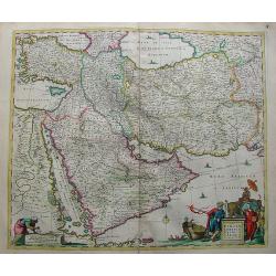
A MAPP of THE ESTATES of the TURKISH EMPIRE in ASIA, and EUROPE, 1669.
A copperplate partly colored map showing Arabie, Asia Minor & Cyprus. This rare example is the earliest folio sized map of the region to be engraved in England by Ric...
Date: London, 1669
Selling price: ????
Please login to see price!
Sold in 2019
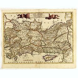
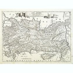
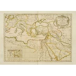
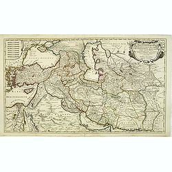
Nova Persiae Armeniae Natoliae et Arabiae.
Decorative map of Persia with Cyprus.
Date: Amsterdam, 1670
Selling price: ????
Please login to see price!
Sold in 2010
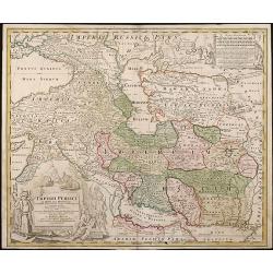
Turicum Imperium.
Attractive map of Turkey, Arabia, Persia and the east Mediterranean region, including Cyprus.
Date: Amsterdam, 1670
Selling price: ????
Please login to see price!
Sold in 2010
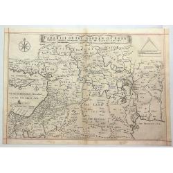
Paradise or the Garden of Eden with the Countries Circumjacent Inhabited by the Patriarchs.
An attractive, detailed map of the middle East region around the Paradise and Garden of Eden, extending from Cyprus to the Persian Sea. The Garden of Eden is located in t...
Date: Amsterdam, ca. 1670
Selling price: ????
Please login to see price!
Sold in 2020
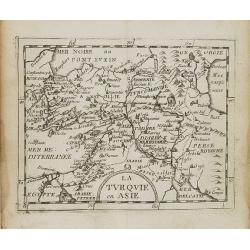
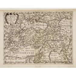
La Turquie en Asie.
Uncommon miniature map of Turkey, Cyprus, Palestine, Iran and Iraq. From Pierre Duval's La Geographie Universeille dated 1676. Following his Cartes de geographie in 1657,...
Date: Paris, 1676
Selling price: ????
Please login to see price!
Sold in 2008
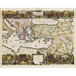
L'empire des Turcs, en Europe, en Asie, et en Afrique, avec les principales routes qu'y tiennent les Caravanes . . .
Scarce map of Turkey widened to the Mediterranean basin with fine title cartouche upper right. Insert map of African coasts (85x193) with a descriptions of caravans main ...
Date: Paris, 1676
Selling price: ????
Please login to see price!
Sold in 2016
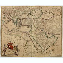
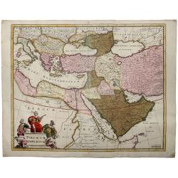
Turcicum Imperium.
Detailed map of the Turkish Empire by Holland's leading mapmaker at the end of the seventeenth century. The cartouche shows an Ottoman administrator or possibly the Sulta...
Date: Amsterdam, 1680
Selling price: ????
Please login to see price!
Sold in 2016
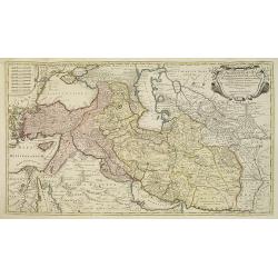
Nova Persiae Armeniae Natoliae et Arabiae.
East from Cyprus to Iran with numerous place names and ornamental cartouches below. There are vignettes of sailing ships in sea areas and the land divisions of the time a...
Date: Amsterdam, 1680
Selling price: ????
Please login to see price!
Sold in 2016
Nova Persiae Armeniae Natoliae et Arabiae.
East from Cyprus to Iran with numerous place names and ornamental cartouches below. There are vignettes of sailing ships in sea areas and the land divisions of the time a...
Date: Amsterdam, 1680
Selling price: ????
Please login to see price!
Sold in 2016
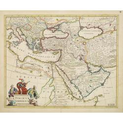
TURCICUM IMPERIUM.
A detailed map of the Turkish Empire by Holland's leading mapmaker at the end of the seventeenth century. The cartouche shows an Ottoman administrator ,or possibly the S...
Date: Amsterdam, 1680
Selling price: ????
Please login to see price!
Sold in 2019
Turcicum Imperium.
Detailed map of the Turkish Empire by Holland's leading mapmaker at the end of the seventeenth century. The cartouche shows an Ottoman administrator or possibly the Sulta...
Date: Amsterdam, 1680
Selling price: ????
Please login to see price!
Sold in 2011
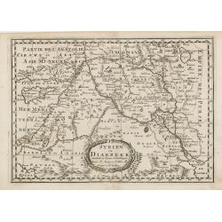
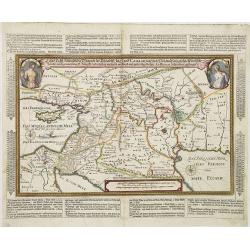
Syrien en Diarbeek verdeelt in hunne Scheidingen.
Engraved map of the Near East, including Cyprus, Palestine, Syria, Iraq, bordered by Greece, Turkey and Iran. The map shows great detail of towns, cities and topography, ...
Date: Utrecht, 1680
Selling price: ????
Please login to see price!
Sold in 2016
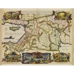
De gelegentheyt van 't Paradys en de 't Landt Canaan..
A finely engraved map of the Middle East from the Mediterranean, including Cyprus, eastwards to Syria and Iraq.At the four corners are insets showing the temptation of Ev...
Date: Amsterdam 1682
Selling price: ????
Please login to see price!
Sold
De Beschrijvingh van de Reysen Pauli..
Decorative map with 8 insets depicting the wanders of Paulus and the Apostles. Dutch text on verso. Covers the territory from Sicily in the Mediterranean Sea to the Persi...
Date: Amsterdam 1682
Selling price: ????
Please login to see price!
Sold
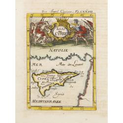
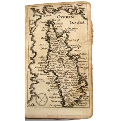
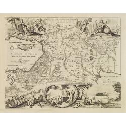
Isles de Cypre.
A charming late 17th century French map of Cyprus with a large pictorial cartouche depicting an infantry combat.By Allain Manneson Mallet (1630-1706), a well traveled mil...
Date: Franckfurt 1684
Selling price: ????
Please login to see price!
Sold
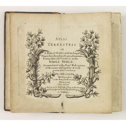
Atlas Terrestris: or a Book of Mapps of all the Empires, Monarchies, Kingdoms, Regions, . . . in the whole World.
One of a series of composite world atlases of varying contents published by John Seller (fl.1658-1698) from 1676 onwards and among one of the very earliest English world ...
Date: London: John Seller, [no date] c. 1684
Selling price: ????
Please login to see price!
Sold in 2010
Kurtze Beschreibung von dem Ursprung, Aufnehmen, Gebiete und Regierung der Weltberühmten Republick Venedig.
Short description of the origin, recording, and government areas of the world-famous “Venice Republick.” The first and only edition of this rare work. The copper eng...
Date: Nuremberg, 1686
Selling price: ????
Please login to see price!
Sold in 2015

Asiae Minoris lacobi cantelly vineolensis...
Giacomo Rossi's fine late 17th century map of Turkey and Cyprus. Issued in Il Mercurio geografico
Date: Rome, 1686
Selling price: ????
Please login to see price!
Sold in 2015
Asiae Minoris lacobi cantelly vineolensis...
Giacomo Rossi's fine late 17th century map of Turkey and Cyprus. Issued in Il Mercurio geografico In upper center a tittle cartouche.The cartographer was Giacomo Cantelli...
Date: Rome, 1686
Selling price: ????
Please login to see price!
Sold in 2016
De Beschryving van de Reysen Pauli en Van de Andere Apostelen.
The Dutch so-called ' Staten' bibles published between 1637 and c. 1760, contained 5 maps: The World, ' Paradise', The Perigrinations, The Promised Land Canaan, The Trave...
Date: Dordrecht-Amsterdam, H. Keur en M. Doornik, 1686
Selling price: ????
Please login to see price!
Sold
Die Insel Cypern / Isles de Cypre
Decorative engraved map of Cyprus from Alain Manesson Mallet. With a interesting battle scene.
Date: Frankfurt, 1686
Selling price: ????
Please login to see price!
Sold in 2009
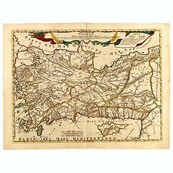
Asia minoris, . . .
Detailed map of Turkey with Cyprus, by Giacomo Cantelli da Vignola (1643-1695). Map Turkey's cities and political divisions as they existed during the Roman Empire.Engrav...
Date: Rome, 1686
Selling price: ????
Please login to see price!
Sold in 2011
Beschryvinge van den Oorsprong der Volkeren, Uit de drie..
A very decorative map of the region from the Mediterranean through to the Persian Gulf, including Cyprus.The map depicts the Garden of Eden, Abraham's route from Ur, and ...
Date: Amsterdam, 1687
Selling price: ????
Please login to see price!
Sold
A mapp of the travels and voyages of the apostles..
The engraver of this map was Richard Palmer.Finely engraved detailed map covering the whole of the eastern Mediterranean. Showing the travels of the apostles after the de...
Date: London 1687
Selling price: ????
Please login to see price!
Sold
De Gelegentheyt van t' Paradys en t' Landt Canaan, mitsgaders d' eerst bewoonde Landen der Patriarchen.
Dutch so-called ' Staten' bibles, published between 1637 and c. 1760, contained 5 maps: The World, ' Paradise', The Perigrinations, The Promised Land Canaan, The Travels ...
Date: Amsterdam, Hendrik Keur en Marcus Doornick, 1688
Selling price: ????
Please login to see price!
Sold in 2009
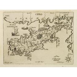
CIPRO
Rare map of the island of Cyprus from Francesco Piacenza's : L'Egeo Redivivo o'sia Chrorographia dell'Arcipelago, e dello stato primiero, & attuale di quell'isole, re...
Date: Modena, 1688
Selling price: ????
Please login to see price!
Sold
Natolia detta anticamente Asia minore...
Giacomo Rossi's fine late 17th century map of Ancient Turkey, with Cyprus. Issued in Il Mercurio geografico In upper center title cartouche.
Date: Rome, 1686-1688
Selling price: ????
Please login to see price!
Sold in 2015
Stato del Gran Turco diviso ne suoi Beglierbati, . . .
Rossi's scarce map of Turkish Empire with the Eastern Mediterranean, Cyprus, Turkey, Arabia, the Black Sea, Asia Minor and neighboring regions.
Date: Rome, 1679-1688
Selling price: ????
Please login to see price!
Sold in 2015
A Mapp of the Travels and Voyages of the Apostales in Their Mission and in Particular of Saint Paul.
Beautiful Holy Land figural map of the travels of St. Paul and the Apostles by Richard Blome and engraved by Jan Kip. A series of thirteen border vignettes featuring the ...
Date: London, 1689
Selling price: ????
Please login to see price!
Sold in 2017
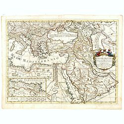
Geographiae Sacrae .. Totius Orbis Partes..
Standard map of the ancient world. Centred on Cyprus. With inset map of Egypt.This edition carries the date 1690.Nicolas Sanson was to bring about the rise of French cart...
Date: Paris 1690
Selling price: ????
Please login to see price!
Sold
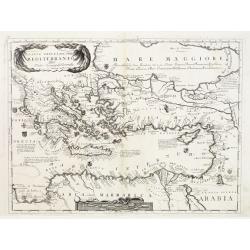
Parte Orientale del Mediterraneo..
A beautiful map depicting the eastern part of the Mediterranean Basin, including a nice representation of Cyprus. With decorative title cartouche and scale cartouche.Hist...
Date: Venice 1690
Selling price: ????
Please login to see price!
Sold
![Parte orientale dell' Europa . . . [Eastern part of Europe with Russia and map of Iceland on verso]](/uploads/cache/39638-250x250.jpg)
Parte orientale dell' Europa . . . [Eastern part of Europe with Russia and map of Iceland on verso]
Eastern part of Europe of a two sheet map. On the verso a map of Iceland "Isola d'Islanda". The Europe map extends from the Turkey (with Cyprus) and the Black s...
Date: Venice, 1695
Selling price: ????
Please login to see price!
Sold in 2020
![Parte orientale dell' Europa . . . [Russia]](/uploads/cache/29452-250x250.jpg)
Parte orientale dell' Europa . . . [Russia]
Eastern part of Europe. The map extends from the Turkey (with Cyprus) and the Black sea, Ukraine and part of the Caspian Sea, up till Nova Zembla. Only the west coast of ...
Date: Venice, 1695
Selling price: ????
Please login to see price!
Sold in 2010
![[Globe gore of the Black Sea, with Russia, Georgia, Cyprus and Gulf of Bassora]](/uploads/cache/29159-250x250.jpg)
[Globe gore of the Black Sea, with Russia, Georgia, Cyprus and Gulf of Bassora]
Half-gore from his 110 centimetres in diameter globe of 1688 with Cyprus, part of Egypt, Saudi Arabia, Crimea, Russia including Ukraine and Moscow. Some of the half-gores...
Date: Venice, 1696
Selling price: ????
Please login to see price!
Sold in 2010
Chersonesi Quae Hodie Natolia Descripto.
Decorative map of Asia Minor extending from Armenia Minor to Hardianopolis and Crete to Cyprus. It was created by Philip Cluverius in 1697.
Date: Leiden, 1697
Selling price: ????
Please login to see price!
Sold in 2018
Ierusalem.
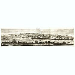
Panoramic view of Jerusalem as viewed from Mount of Olives with several figures in the foreground. Cornelis de Bruyn (1652-1726) was a painter who traveled through the Ho...
Date: Delft, Henrik van Krooneveld, 1698
Selling price: ????
Please login to see price!
Sold in 2018
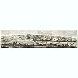
Ierusalem.
Panoramic view of Jerusalem as viewed from Mount of Olives with several figures in the foreground. Cornelis de Bruyn (1652-1726) was a painter who traveled through the Ho...
Date: Delft, Henrik van Krooneveld, 1698
Selling price: ????
Please login to see price!
Sold in 2011
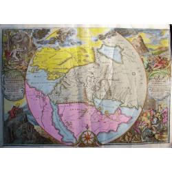
ORBIS PER CREATIONEM INSTITUTUS; ORBIS PER DILUVIUM DESTITIUTUS
Attractive and rare map centered on the Garden Eden. Shows the Near East with Holy Land Israel, Syria, Jordania, Palestine, Arabia, Yemen, the Emirates, Egypt, Turkey, C...
Date: Amsterdam, c 1700
Selling price: ????
Please login to see price!
Sold in 2008
Persia sive Sophorum regnum cum Armenia Assyria Mesopotamia et Babylonia.
Uncommon map of the Near East, including Cyprus, Holy Land, Armenia, etc.
Date: Amsterdam, 1700
Selling price: ????
Please login to see price!
Sold in 2008
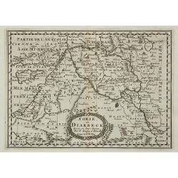
Sorie, et Diarbeck.
An attractive miniature prepared by N.Sanson. Covering the Syrian desert, Lebanon, and the mouth of the Tigris in the Persian Gulf. Including Babylon, Tripoli, Palestine,...
Date: Paris, c.1700
Selling price: ????
Please login to see price!
Sold in 2011
Land Tafel darinnen die gegendt des Paradijs das land Canaan. . .
Beautiful and rare map showing the Holy Land, Syria, Cyprus, Iran, Iraq, etc. With inset portraits showing Adam and Eve. Scale in lower part, with little cartouche giving...
Date: Germany, ca. 1700
Selling price: ????
Please login to see price!
Sold in 2010
![[Title page] Voyage de C. de Brun.](/uploads/cache/31056-250x250.jpg)
[Title page] Voyage de C. de Brun.
Title pages from Cornelis de Bruijn's first travel book, engraved by J.Mulder.Cornelis de Bruijn (c.1652-1727) was a Dutch artist and traveler. He is best known for his d...
Date: Delft, H. de Krooneveld, 1700
Selling price: ????
Please login to see price!
Sold in 2011
Terra Sancta Christi et Deiparae patria ..
A map from the series of maps by the Jesuit mathematician. A general map of eastern part of Medeteranean with Holy Land and Cyprus, produced by Scherer to show the spread...
Date: Munich c.1702
Selling price: ????
Please login to see price!
Sold
Patriarchatus Ierosolymitanus comprehendebat tres provincias..
A map from the series of maps by the Jesuit mathematician. A general map of the Holy Land and Cyprus (only listing town of Constantia, produced by Scherer to show the spr...
Date: Munich c.1702
Selling price: ????
Please login to see price!
Sold
Asia Minor.
A fascinating and detailed map of Asia Minor, from an English edition of Cellarius' Geographia Antiqua. Cyprus prominent, as are many of the Greek Islands
Date: Germany, 1703
Selling price: ????
Please login to see price!
Sold in 2015
Turkyen in Asia.
Attractive general map of the Middle East, including Turkey, Cyprus, Palestine, etc.
Date: Amsterdam 1705
Selling price: ????
Please login to see price!
Sold
Theatrum Historicum.. Tu Imperii Romani.. Pars Orientalis..
Showing the Eastern part of the Roman Empire, extending from Greece and Cyprus to India and centered on Armenia and the Black and Caspian Seas. Prepared by G. de l'Isle, ...
Date: Paris, 1705
Selling price: ????
Please login to see price!
Sold in 2009
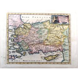
Anatolien. (with Cyprus)
A Dutch edition of Sanson Jr.'s map of Turkey. In the lower right corner is an oversized Cyprus. Engraved by Anthony d'Winter.
Date: Amsterdam, 1705
Selling price: ????
Please login to see price!
Sold in 2022
M. Heberers Ongelukige Voyagie gedaan in Verscheyde gedeeltens van Asia en Africa.
Pieter van der Aa was a prolific publisher. He published a.o. ' Naaukeurige versameling der gedenkwaardigste zee- en land-reysen', a series of accounts of voyages (1706-0...
Date: Leiden, 1707
Selling price: ????
Please login to see price!
Sold
Paskaart van 't Oosterste deel vande Middellantsche Zee Vervattende de Zee-kusten van Caramania Cyprus Soria en Aegiptia.
This sea chart represents Cyprus as well as the eastern coasts of the Mediterranean Sea.From van Keulen's "De Nieuwe Groote Lichtende Zee-Fackel, part III.3.3. The a...
Date: Amsterdam, 1708
Selling price: ????
Please login to see price!
Sold
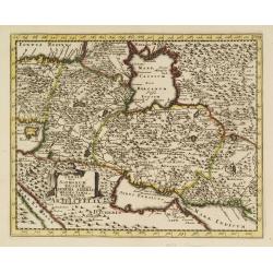
Carte de Geographie des Differents Etats de la Republique de Venise. . .
An attractive and detailed engraving of the Gulf of Venice and adjacent Italian and Dalmatian coastlines. The main map runs diagonally across the sheet with inset detail ...
Date: Amsterdam, 1710
Selling price: ????
Please login to see price!
Sold in 2019
Asia Minor..
Rare map of Turkey and Cyprus, published by Pierre Moullart-Sanson, who was the grandson of Nicolas the elder.The two title cartouches are printed from different copperpl...
Date: Paris 1710
Selling price: ????
Please login to see price!
Sold
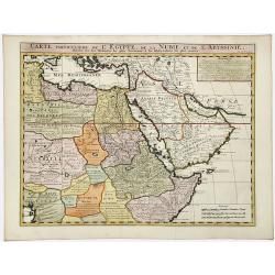
CARTE Particuliere de L' EGYPTE, de la NUBIE, et de L' ABYYSSINIE.
Detailed map of Cyprus, Asia Minor, the Middle East and North Africa, colored by regions.
Date: Amsterdam, 1711
Selling price: ????
Please login to see price!
Sold in 2020
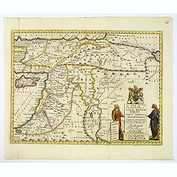
A New Map of The Eastern Parts of Asia Minor. . .
A very pleasant map showing eastern Turkey, Cyprus, the Holy Land, Armenia, Lebanon, Syria, and Iraq. Map features a decorative title cartouche, and the heraldic arms of ...
Date: Oxford, ca. 1712
Selling price: ????
Please login to see price!
Sold in 2018
Die Gelegenheit des Paradeis und des Landes Canaan, sambt den erst Bewohnten Lõnderen der Patriarchen aus H. Schrift u anderen Auctoren zusamen getragen
Very rare anonymous map of the Middle East. Based on the "Paradise Map" of Visscher. Showing the Eastern Mediterranean with Cyprus up to today Iraq / Iran in th...
Date: Minden, 1716
Selling price: ????
Please login to see price!
Sold in 2009
Syriae Sive Soriae Nova et Accurata Desctiptio.
Striking copper engraved map of Syria and Lebanon with a slice of Turkey, including Cyprus. Embellished with decorative, figured title and scale cartouches including four...
Date: 1717
Selling price: ????
Please login to see price!
Sold in 2014
Asia peninsula sive Asia intra Taurum. . . (with Cyprus)
Striking map the Black Sea, Cyprus and Asia Minor, featuring the geographical features known to the ancients and decorated with a vignette and 27 medallions.From "De...
Date: Nuremberg, 1718
Selling price: ????
Please login to see price!
Sold in 2015
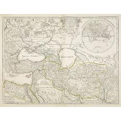
Regnum Persicum Imperium Turcicum in In Asia Russorum Provinciae ad Mare Caspium . . .
Striking map of the region bounded by Cyprus and the Eastern Mediterranean, the Nile, Medina, the Persian Gulf and the Indus River in the south and the Black Sea, Circass...
Date: Amsterdam, 1720
Selling price: ????
Please login to see price!
Sold in 2012
Imperii Persici In Omnes Suas Provincias
Hand colored copper engraving by J.B. Homann, showing Persia between Astrakhan, Kabul, Arabic Sea and Cyprus.
Date: Nuremberg, 1720
Selling price: ????
Please login to see price!
Sold in 2008
Regnum Persicum Imperium Turcicum in In Asia Russorum Provinciae ad Mare Caspium. . .
Striking and rare map of the region bounded by Cyprus and the Eastern Mediterranean, the Nile, Medina, the Persian Gulf and the Indus River in the south and the Black Sea...
Date: Amsterdam, 1720
Selling price: ????
Please login to see price!
Sold in 2010
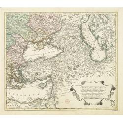
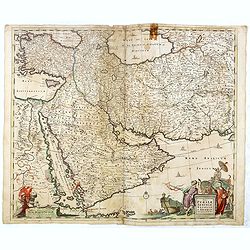
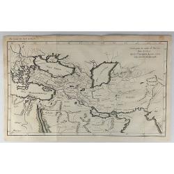
Area between the Black Sea and the Caspian Sea.
Nice and scarce map encompassing part of the Near East and the area comprehended between the Black Sea and the Caspian Sea.Centered on Turkey, with an oversized Cyprus. I...
Date: Nuremberg, ca 1720
Selling price: ????
Please login to see price!
Sold in 2016
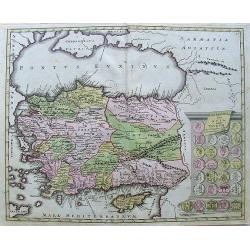
Asia Peninsula sive Asia Intra Taurum
Nice Handcolored map of Turkey and Cyprus. There is an inset with coins from that time.
Date: Nurnberg, 1720
Selling price: ????
Please login to see price!
Sold in 2010
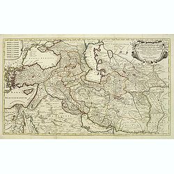
Regnum Persicum Imperium Turcicum in In Asia Russorum Provinciae ad Mare Caspium. . .
Striking and rare map of the region bounded by Cyprus and the Eastern Mediterranean, the Nile, Medina, the Persian Gulf and the Indus River in the south and the Black Sea...
Date: Amsterdam, 1720
Selling price: ????
Please login to see price!
Sold in 2011
Imperii Orientalis Circumjacenttium..Constantiono..
Including Greece, Cyprus, Ukraine, Moldavia and the Black Sea.
Date: Paris, 1722
Selling price: ????
Please login to see price!
Sold in 2008
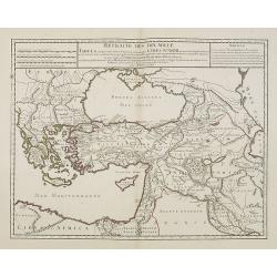
Retraite des Dix Mille Tabula conspectum exhibens Regionum omnium quas Cyrus Junior, Artaxerxi fratibellum illaturus ac Cyro in acie caeso. . .
Depicting ancient Turkey and Greece, including Cyprus, Black Sea, Iraq and Persia.
Date: Paris, 1723
Selling price: ????
Please login to see price!
Sold in 2008
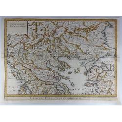
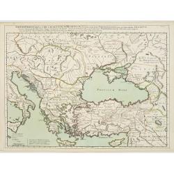
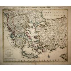
Graeciae Pars Septentrionalis.
A large and dramatic map by de L'Isle of the northern Greece, the Balkans, and Macedonia. Map extent covers from Dalmatia east to the Black Sea (Pontus Euxinus) and south...
Date: London, 1725
Selling price: ????
Please login to see price!
Sold in 2018
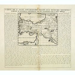
Carte De L'Asie Inferieure Selon Les Auteurs Anciens, Enrichie de Remarques Historiques sur les Changemens qui y sont arrivez (shows Cyprus)
Text page with inset map (220x269.mm.) of Turkey, including Cyprus. From Chatelain's Atlas Historique, 1732-1739. In upper right margin: 'Tom. V. No 3. Pag: 16.'
Date: Amsterdam, 1728
Selling price: ????
Please login to see price!
Sold in 2012
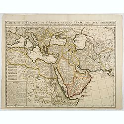
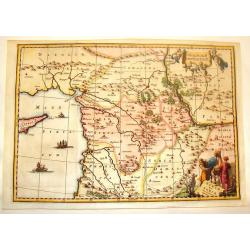
Carte de la Turquie, de la L'Arabie et de la Perse..
Including the Arabian Peninsular, Egypt, Persia, Caspian Sea, north eastern part of Africa, Cyprus and Mediterranean. From Chatelain's monumental 7 volume "Atlas His...
Date: Amsterdam, 1728
Selling price: ????
Please login to see price!
Sold in 2017
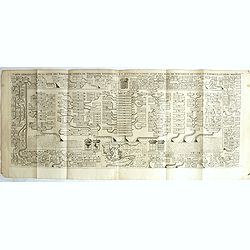
Carte genealogique de la suite des empereurs d'orient de Trebisonde, d'Andrinople et Ottomans. . .
With a small inset map at the lower center, this grand genealogical table displays the Kings of the Orient and the Ottomans, with those of Jerusalem, Cyprus and Armenia.H...
Date: Amsterdam, 1728
Selling price: ????
Please login to see price!
Sold in 2019
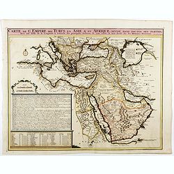
Carte de L'Empire des Turcs en Asie & en Afrique..
Including the Arabian Peninsula, Egypt, Cyprus, and part of the Mediterranean. In the upper right corner is a large Caspian Sea, filled with notes. To the right, the Rive...
Date: Amsterdam, 1728
Selling price: ????
Please login to see price!
Sold in 2025
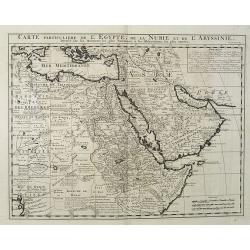
Carte Particuliere De L'Egypte, De La Nubie et de L'Abyssinie, Dressee sur les Memoires les plus Nouveaux & les Observation les plus exactes.
Including the Arabian Peninsular, Egypt, north eastern part of Africa, Cyprus and part of the Mediterranean.Based on the work of Guillaume Delisle. It is a very detailed ...
Date: Amsterdam, 1728
Selling price: ????
Please login to see price!
Sold in 2016
Carte pour la Route de Xerxes dans la Grece et Pour l'Expedition du Jeune Cyprus et la Retraite des Dix Mille.
A striking map of Greece. The map for the Route of Xerxes in Greece and For the Expedition of the Young Cyprus, and the Retreat of the Ten Thousand. It is from “METHODE...
Date: Paris, 1729
Selling price: ????
Please login to see price!
Sold in 2020
Deserta Aegypti Thebaidies Arabiae Syriae etc. ubi accurate notata sunt loca inhabitata per Sanctos Patres Anachoreatas.
Original engraved map of Egypt, Northern Arabia, the Holy Land, Syria and Cyprus, with original hand coloring. Verso blank. An attractive map of Egypt, northern Arabia, t...
Date: Augsburg, 1730
Selling price: ????
Please login to see price!
Sold in 2020
Cypre, île de la Méditerrannée.
This map by van der Aa copies the Cyprus map of Willem Blaeu . It is smaller in size and Blaeu's exquisite decorative treatment has been replaced by a cartouche and new p...
Date: Leiden 1730
Selling price: ????
Please login to see price!
Sold
Carte de la Grece.
A striking, large map detailing Greece, the western part of Turkey and extending to show Albania, Macedonia and part of Cyprus. Latin title at top "Accurata Totius A...
Date: Amsterdam, 1730
Selling price: ????
Please login to see price!
Sold in 2008