Browse Listings in Europe > Switzerland
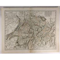
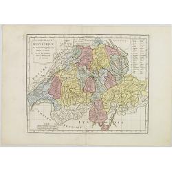
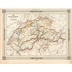
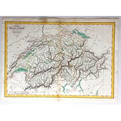
Carte Physique et Politique de la Suisse.
A finely engraved map of Switzerland issued in an “Atlas Universel de Géographie Physique et Politique, Ancienne et Moderne”, which was published in by Mentelle and...
Date: Paris, 1798
Selling price: ????
Please login to see price!
Sold in 2017
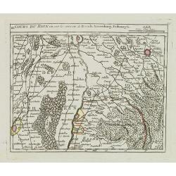
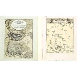
III. Cours du Rhin où sont les environs de Brisach, Newenburg, Fribourg &c.
Small detailed map illustrating the stretch of the Rhine which flows between Nuremburg and Breisach am Rhein.From Atlas Portatif Universel, by Robert de Vaugondy.Page 34c...
Date: Paris, 1799
Selling price: ????
Please login to see price!
Sold in 2021
Charte von Helvetien und Wallis.
A pleasing map of Switzerland and Northern Italy. Detailed topography with mountains, rivers and lakes. The mapmaker was Goetze from Weimar in 1803. Four informational i...
Date: Weimar, 1803
Selling price: ????
Please login to see price!
Sold in 2016
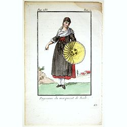
Paysane du marquisat de Bade.
Originally hand-colored mezzotint from 'Costumes civils actuels de tous les peuples connus'. After Jacques Grasset de Saint-Sauveur. As an etcher, drawer and writer, Gras...
Date: Paris,1805
Selling price: ????
Please login to see price!
Sold in 2017
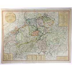
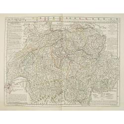
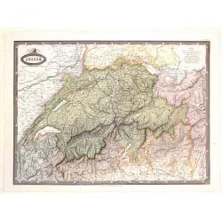
La République Helvétique en ses 19 Cantons.
Map of Switzerland. By C. F. Delamarche, successor of Robert de Vaugondy, Geographer.
Date: Paris, 1794 - 1806
Selling price: ????
Please login to see price!
Sold in 2019
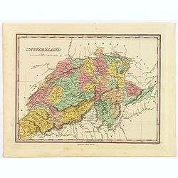
Swisserland
A fine map of Switzerland by John Thomson in 1817. It is divided into two parts, the top part of the sheet covers the Helvetic Confederation of Switzerland, as divided in...
Date: Edinbourgh, 1817
Selling price: ????
Please login to see price!
Sold in 2019
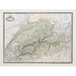
Carte de Suise ou sont les Cantos de Zurich Berne . . .
Very interesting map of Switzerland, colored in outline. Along the top 26 coats of arms of the diverent cantons. Buache drew heavenly on the work of Delisle. This edition...
Date: Paris, 1818
Selling price: ????
Please login to see price!
Sold
Bern gegen das Ende des dreyzehnten j./ Kriegs-Schauplatz..
Lot of 2 prints showing Bern in ancient times.
Date: Austria 1813/1821
Selling price: ????
Please login to see price!
Sold in 2008
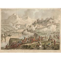
Napoleon & Massena Defeating The Austrian Army, At The Terrible Battle of Roveredo.
Napoleon & Massena defeating The Austrian Army, at The Terrible Battle of Roveredo, engraved by George Cruikshank from the original design of C. Vernet, executed at P...
Date: London, 1823
Selling price: ????
Please login to see price!
Sold in 2020
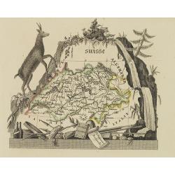
Suisse
Attractive map of Switzerland with decorative borders depicting typical artifacts and produce of the continent. Published in Les jeunes voyageurs en Europe.. . Engraved b...
Date: Brussels, 1824
Selling price: ????
Please login to see price!
Sold in 2020
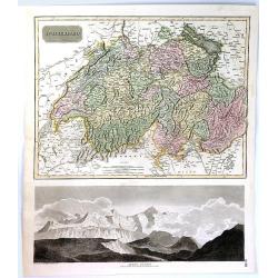
Switzerland.
A beautiful example of Finley's 1827 map of Switzerland. With Finley's classic minimalist style, this map identifies cities, forests, river systems, swamps and mountains....
Date: Philadelphia, 1827
Selling price: ????
Please login to see price!
Sold in 2019
Carte routière de la Suisse . . .
Road map of Switzerland, prepared by A. H. Basset, rue Saint-Jacques, no. 64, Paris and published in Atlas classique et Universel de Géographie . . . .The engraver of th...
Date: Paris, A.H. Basset, 1828
Selling price: ????
Please login to see price!
Sold
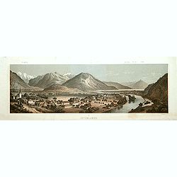
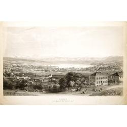
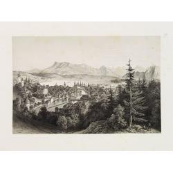
Interlaken.
Decorative panoramic view of the town of Interlaken, with in left hand corner the mountain Jung-Frau.Lithographed by Deroy.
Date: Paris, ca. 1840
Selling price: ????
Please login to see price!
Sold
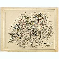
Schweiz gezeichnet von G.Asbach.
Fine manuscript map of Switzerland.
Date: Germany, ca. 1843
Selling price: ????
Please login to see price!
Sold in 2018
Switzerland (Die Schweiz ; La Suisse)
Large striking map of Switzerland by W & A.K. Johnston in Edinburgh in 1843. It definitely shows the high level of mountains in the country. It features an insert of ...
Date: Edinburgh, 1843
Selling price: ????
Please login to see price!
Sold in 2017
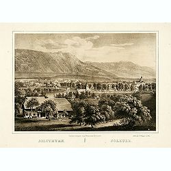
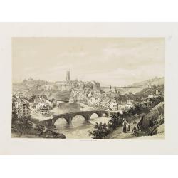
Solothurn.
"The lithography is made after a Daguerreotype by Franziska Möllinger. Lithographed by J. P. Wagner."
Date: Bern, 1845
Selling price: ????
Please login to see price!
Sold
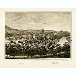
Bern.
The lithography is made after a Daguerreotype by Franziska Möllinger. Lithographed by J. P. Wagner.
Date: Bern, 1845
Selling price: ????
Please login to see price!
Sold in 2013
Carte de la Suisse..
Decorative map of Switzerland, prepared by J.G.Barbié du Bocage.Engraved by Ch.Smith, published by Basset who was established in Paris, rue de Seine 33. From atlas Illus...
Date: Paris, 1846
Selling price: ????
Please login to see price!
Sold in 2009
ZURICH prise depuis la Weid Coté du Nord.
Very decorative bird's-eye view of Zürich, engraved by Hurlimann and published by H.F.Leuthold. After a design by Burri.
Date: Zürich c.1850
Selling price: ????
Please login to see price!
Sold
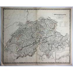
Switzerland.
A very decorative steel-engraved map of Switzerland. Very detailed with numerous place names, mountains, rivers, hills, lakes, etc. Locates the Mount Blanc, Lake Como, an...
Date: London, 1851
Selling price: ????
Please login to see price!
Sold in 2016
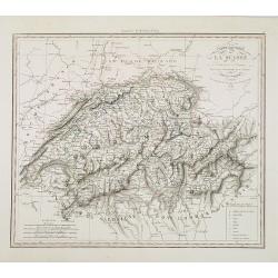
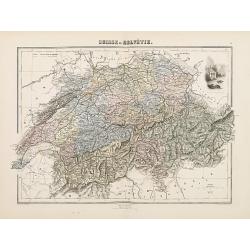
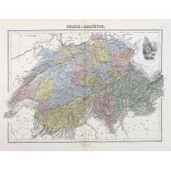
Carte de la Suisse, or Helvetie, par Delamarche, 1858.
Unusual map of Switzerland that has been boldly engraved to feature the remarkable mountainous topography of Switzerland. Charles-François Delamarche (1740 - 1817) was a...
Date: Paris , 1858
Selling price: ????
Please login to see price!
Sold in 2017
Lucerne.
Uncommon and decorative lithography of Lucerne, published by Carl Johan Billmark and printed by Lemercier in Paris, 55 rue de Seine, the leading firm in Europe at that ti...
Date: Paris, c.1859
Selling price: ????
Please login to see price!
Sold
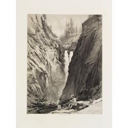
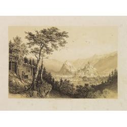
Cascade de Handeck.
Uncommon and decorative lithography published by Carl Johan Billmark and printed by Lemercier in Paris, 55 rue de Seine, the leading firm in Europe at that time. From: It...
Date: Paris, c.1859
Selling price: ????
Please login to see price!
Sold
Vallée d'Interlacken.
Uncommon and decorative lithography published by Carl Johan Billmark and printed by Lemercier in Paris, 55 rue de Seine, the leading firm in Europe at that time. From: It...
Date: Paris, c.1859
Selling price: ????
Please login to see price!
Sold
Fribourg.
Uncommon and decorative lithography of Freiburg, published by Carl Johan Billmark and printed by Lemercier in Paris, 55 rue de Seine, the leading firm in Europe. From: It...
Date: Paris, c.1859
Selling price: ????
Please login to see price!
Sold
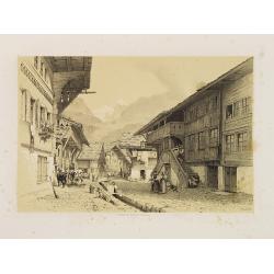
Rue à Meyringen, Vallée de Hasli.
Uncommon and decorative lithography published by Carl Johan Billmark and printed by Lemercier in Paris, 55 rue de Seine, the leading firm in Europe at that time. From: It...
Date: Paris, c.1859
Selling price: ????
Please login to see price!
Sold in 2015
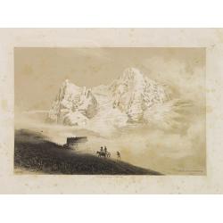
Auberge sur le Wengern-Alp.
Uncommon and decorative lithography published by Carl Johan Billmark and printed by Lemercier in Paris, 55 rue de Seine, the leading firm in Europe at that time. From: It...
Date: Paris, c.1859
Selling price: ????
Please login to see price!
Sold in 2014
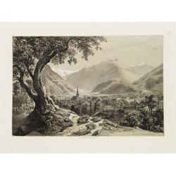
Sion.
Uncommon and decorative lithography published by Carl Johan Billmark and printed by Lemercier in Paris, 55 rue de Seine, the leading firm in Europe at that time. From: It...
Date: Paris, c.1859
Selling price: ????
Please login to see price!
Sold in 2014
Zwitseland en het Vorstendom Lichtenstein.
Uncommon map of Switzerland and Lichtenstein. Lithography by J.H. van Weijer, published in Atlas der geheele Aarde [?] in 24 kaarten.
Date: Groningen, ca. 1860
Selling price: ????
Please login to see price!
Sold in 2008
Suisse.
Detailed map of Switzerland and surrounding regions. It comes from "ATLAS SPHEROIDAL & UNIVERSEL DE GEOGRAPHIE". published in Paris by Jules Renouard in 186...
Date: Paris, 1860
Selling price: ????
Please login to see price!
Sold in 2017
Suisse.
Very detailed map from Atlas Sphéroïdal & Universel de géographie , Prepared by F.A.Garnier and edited by Jules Renouard, rue de To...
Date: Paris, 1861
Selling price: ????
Please login to see price!
Sold in 2010
Suisse et Nord de l'Italie.
Large and very detailed lithographed map of Switzerland. Includes also Austria until Innsbruck, Italy until Modena, France until Grenoble, and Germany until Munich. V...
Date: Paris, 1865
Selling price: ????
Please login to see price!
Sold in 2013
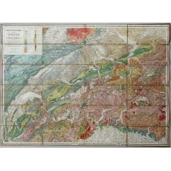
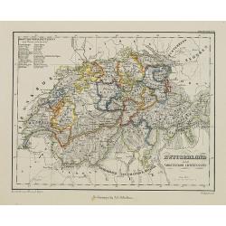
Carte Geologique de la Suisse de M.M.B. Studer et A. Escher von der Linth. 2nd Edition revue et corrigée d'après les publications récentes et les communications des auteurs et de M.M. v. Fritsch, Gilleron, Jaccard, Kaufmann, Mösch, Müller, Stoppani, Théob
Lithographic map, dissected and laid on linen as issued. When folded the map is protected by two contemporary "leather" covers with the title imprinted in gold....
Date: Winterthur, 1869
Selling price: ????
Please login to see price!
Sold in 2020
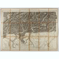
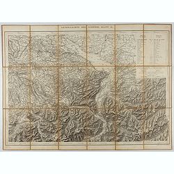
Generalkarte der Schweiz. Blatt IV.
Folding map showing the area from Mainz in the north to Bergamo and Como in the south. The map, engraved by Müllhaupt, is probably part of the 'Topographical Atlas of th...
Date: Bern, 1873
Selling price: ????
Please login to see price!
Sold in 2023
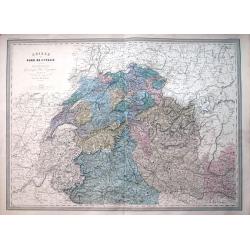
Suisse ou Helvétie.
Decorative map of Switzerland from Géographie Universelle, Atlas Migeon. published by J. Migeon. Very nice engraving of view of the Chapel of Willem Tell. Engraving by S...
Date: Paris, 1874
Selling price: ????
Please login to see price!
Sold in 2011
Suisse ou Helvétie.
A decorative map of Switzerland from Géographie Universelle, Atlas Migeon, published by J. Migeon. With an engraving of William Tell's Chapel in the upper right corner. ...
Date: Paris, 1874
Selling price: ????
Please login to see price!
Sold in 2012
Generalkarte der Schweiz. Blatt II.
Folding map showing Lake Constance and surroundings. The map, engraved by Müllhaupt, is probably part of the 'Topographical Atlas of the Federal General Staff reduced un...
Date: Bern, 1875
Selling price: ????
Please login to see price!
Sold in 2021
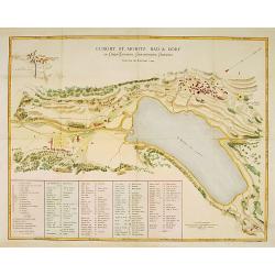
Curort St.Moritz Bad & Dorf in Ober-Engadin. . .
A detailed plan of St.Moritz, with extensive key to the principal places of interest.
Date: Zürich 1876
Selling price: ????
Please login to see price!
Sold
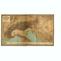
Wandkarte der Alpen nach dem Entwurfe & unter der Leitung des Vinzenz von Haardt ausgeführt in Ed. Holzel's geographischem Institut in Wien...
Large folding map of French and Swiss Alps. Hölzels' masterpiece of cartography, edited by Vincent von Haardt. Eduard Hölzel opened in 1844 a bookstore in Olomouc (now...
Date: Vienna, 1885
Selling price: ????
Please login to see price!
Sold in 2019
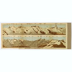
Panorama vom Gornergrat.
The Gornergrat is situated in Switzerland, between the Gornergletscher and Findelgletscher and offers views of more than 20 four-thousand metre peaks, whose highest are t...
Date: London, ca 1893
Selling price: ????
Please login to see price!
Sold in 2019
![[Mont-Blanc].](/uploads/cache/46165-250x250.jpg)
[Mont-Blanc].
A detailed map cantered on the Mont Blanc and its vicinities published by the very successful St. Petersburg publisher "Cartographic institution A.Ilina".Alexey...
Date: St. Petersburg, 1899
Selling price: ????
Please login to see price!
Sold in 2022
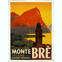
Funicolare Monte Brè Lugano Suisse. Cassarate-Catagnola.
Rare and authentic poster of Lake Lugano, situated in the Switzerland mountains, with a view of the Funicolare of Monte Brè.Designed by Otto Ernst and printed and publis...
Date: Lugano, ca. 1930
Selling price: ????
Please login to see price!
Sold in 2024
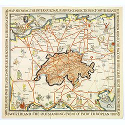
Switzerland The very Heart of Europe / and her International Railway Connections.
A fun map of a centrally positioned Switzerland, mapped in some detail, surrounded by all her many connecting train routes with her neighboring countries. Cities outside ...
Date: Zurich, 1933
Selling price: ????
Please login to see price!
Sold in 2018
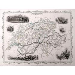
Map of the Republic Switzerland, describing its 22 cantons.
Very detailed map of Switzerland. Upper right hand corner geographical notes, lower left, explanations of the signs.James Wyld (the younger) was geographer to the Queen a...
Date: London 1855/64
Selling price: ????
Please login to see price!
Sold
Die Eydtgnoschafft,oder das Schwytzerlandt. . .
An antique map of Switzerland and the source of the Rhine, by Sebastian Munster.One of the Earliest Modern Maps of Switzerland. This map is also the first of the 3 sheets...
Date: Basel, ca 1550
Selling price: ????
Please login to see price!
Sold in 2020
![L'effigie de la ville de Saleurre. . . [Solothurn]](/uploads/cache/85032-250x250.jpg)
L'effigie de la ville de Saleurre. . . [Solothurn]
A fine (woodcut) panoramic town-view of Solothum with the River Aar in the foreground. In lower right CS. There is no information available for the monogamist CS, however...
Date: Basel, ca 1550
Selling price: ????
Please login to see price!
Sold in 2021
![LA VILLE DE CHOURES. . .[Chur]](/uploads/cache/85033-250x250.jpg)
LA VILLE DE CHOURES. . .[Chur]
A fine woodcut panoramic view of Chur, by Sebastian Muenster, ca. 1550. Chur is the oldest town in Switzerland and the capital of the Canton of Graubünden/Grisons. Chur ...
Date: Basel, ca 1550
Selling price: ????
Please login to see price!
Sold in 2021
![Baden im Argow. Baden Argoiae. [Baden]](/uploads/cache/84274-250x250.jpg)
Baden im Argow. Baden Argoiae. [Baden]
A map of Baden in Switzerland, published by Merian and his heirs in various works, including the Archontologia cosmica, Theatrum Europaeum and the Topographia Germaniae. ...
Date: Frankfurt, 1646 ca
Selling price: ????
Please login to see price!
Sold in 2020
