Browse Listings in Europe > Scandinavia > Denmark
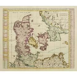
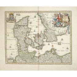
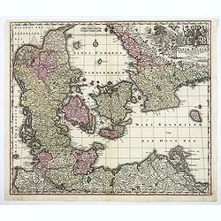
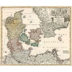
![[ Lot of 9 maps and plans] Novissima nec non Perfectissima Scandinaviae Tabula](/uploads/cache/18177-(3)-250x250.jpg)
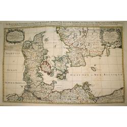
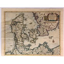
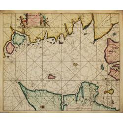
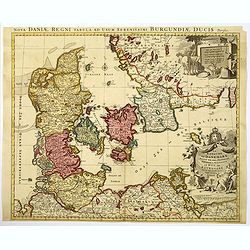
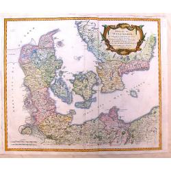
[ Lot of 9 maps and plans] Novissima nec non Perfectissima Scandinaviae Tabula
Frederick de Wit's large and detailled map of Scandinavia. Embellished with a large, decorative title-cartouche.From Frederick de Wit's' Atlas Maior'. Frederik de Wit (16...
Date: Amsterdam, 1690
Selling price: ????
Please login to see price!
Sold in 2022
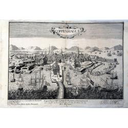
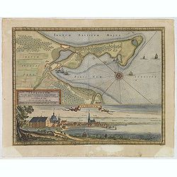
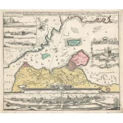
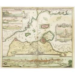
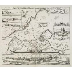
Coppenhague Ville Capitale du Royaume de Danemarck est située en Zeelande qui est une des Isles de la Mer BALTIQUE
Very rare, large decorative view of Copenhagen. The view shows an elaborate waterfront image, with wharves, windmills, shipbuilding, etc. 7 major sites are identified in ...
Date: Paris?, ca 1690
Selling price: ????
Please login to see price!
Sold in 2023
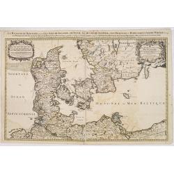
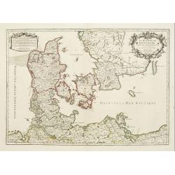
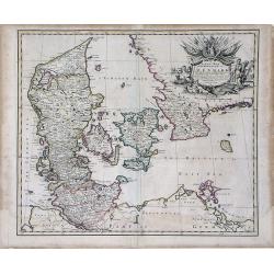
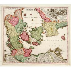
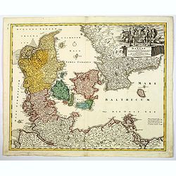
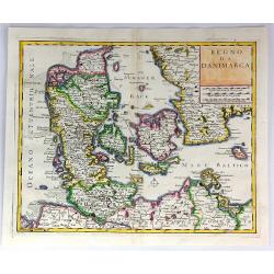
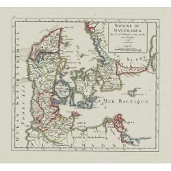
Le royaume de Danemark.
Fine map of Denmark with a decorative title and scale cartouche.Alexis-Hubert Jaillot (1632-1712), was a French cartographer. He joined the Sanson heirs and redrew Nicola...
Date: Amsterdam, 1692
Selling price: ????
Please login to see price!
Sold in 2013
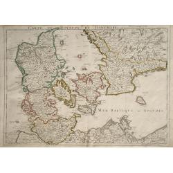
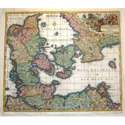
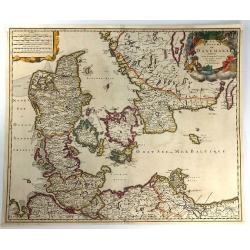
Le Royaume de Danmark.
Large scale map of Denmark. Prepared by Sanson and published by Jaillot.Very large and decorative piece.
Date: Paris 1692
Selling price: ????
Please login to see price!
Sold
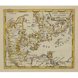
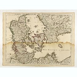
Danemarq et Sud-Gothlande.
Lovely small map of Denmark.
Date: Antwerp, 1692
Selling price: ????
Please login to see price!
Sold in 2011
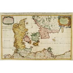
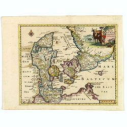
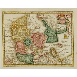
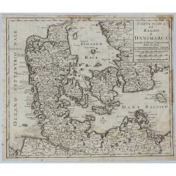
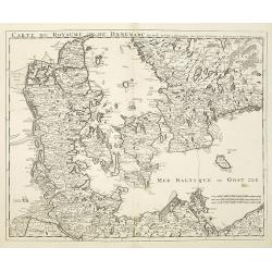
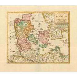
Le Royaume de Danemark subdivisé en ses Principales Provinces..
Handsome map of Denmark and part of Sweden.
Date: Paris, 1692
Selling price: ????
Please login to see price!
Sold in 2009
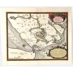
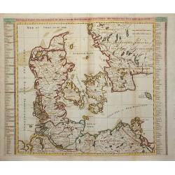
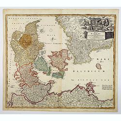
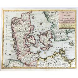
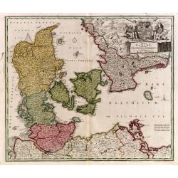
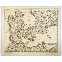
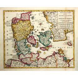
![[Lot of 8 maps of Denmark and Scandinavia] Le Royaume de / Danemark / subdicise en ses principales provences.via](/uploads/cache/18385-(4)-250x250.jpg)
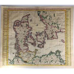
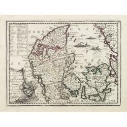
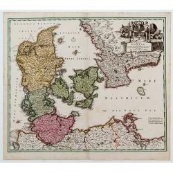
[Lot of 8 maps of Denmark and Scandinavia] Le Royaume de / Danemark / subdicise en ses principales provences.via
Alexis-Hubert Jaillot (1632-1712), French cartographer. He joined the Sanson heirs and redrew Nicolas Sanson's maps on a larger scale. 'Atlas Nouveau' (1674), sea-atlas '...
Date: 1692
Selling price: ????
Please login to see price!
Sold in 2022
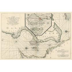
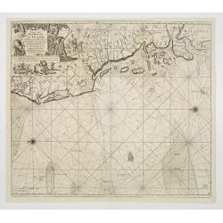
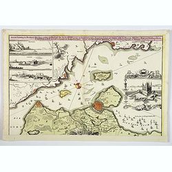
Carte de Detroit du Sond Contenant les Costes de L'Isle de Zélande Comprises ente Nicopen et L'Isle de Meun, et Celles du Schonen Depuis la Pointe de Kol, jusqu'a Valsterbon.
This is a lovely nautical chart of the sound between Sweden and Denmark produced during the golden age of map making. This sea chart was part of Pierre Mortier's 'Le Nept...
Date: Amsterdam 1693
Selling price: ????
Please login to see price!
Sold in 2023
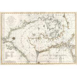
Carte de la Mer de Dannemark et des Entrees dans la Mer Baltique
This magnificent, important sea chart is the work of French statesman Alexis-Hubert Jaillot. It is from the first edition of a French sea atlas entitled Neptune François...
Date: 1693
Selling price: ????
Please login to see price!
Sold in 2023
Accurata Delineatio Castrorum Suecicorum ut et Haffniae
A bird’s-eye view of an important battle for the defending of Copenhagen, Denmark. With very attractive decorative cartouches, a compass rose, and a border and featurin...
Date: Nuremburg, 1696
Selling price: ????
Please login to see price!
Sold in 2016
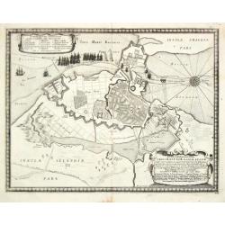
Accurata Delineatio Oppugnatae a Federatis, Caesareis, Polonicis, Danicis...
This beautiful bird’s-eye map shows part of the Danish island of Fyn and Jutland with Swedish, Polish and Danish forces in the Baltic. A lettered key identifies 12 loca...
Date: Nuremburg, 1696
Selling price: ????
Please login to see price!
Sold in 2016
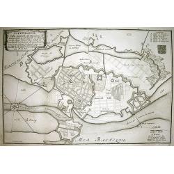
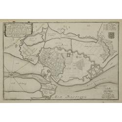
Delineatio Geometrica Urbis Haffniae Daniae Regum.
A bird's-eye plan of the important fort defending Copenhagen. The Danish navy fills the sea, and the map is adorned with decorative title and key cartouches and a detaile...
Date: Stockholm, 1696
Selling price: ????
Please login to see price!
Sold in 2020
Delineatio Geometrica Urbis Haffniæ, Daniæ Regum ...
Detailed copper engraved map featuring a panoramic view of Copenhagen, Capital of Denmark, besieged by Swedish forces from 11th (21st) August 1658. This time instead of c...
Date: Nuremburg, 1696
Selling price: ????
Please login to see price!
Sold in 2020
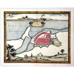
Ichnographia Areis et Oppidi Nicoplae.
A striking city map of Nykobilg, Denmark by Pufendorf in 1696. Freiherr Samuel von Pufendorf (1632–1694) was a German jurist, political philosopher, economist and histo...
Date: Stockholm, 1696
Selling price: ????
Please login to see price!
Sold in 2023
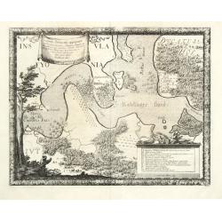
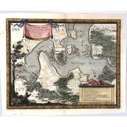
Baltus minor / Koldinger fiord.
From Pufendorf's famous chronicle on the Baltic area, ' Histoire du règne de Charles Gustave, roy de Suède'A map of the Lille Belt near Kolding.
Date: Nürnberg, C. Riegel, 1697
Selling price: ????
Please login to see price!
Sold in 2008
Typus Solemnitatum quibus Tabula pacis inter regna Sueciae et Daniae.
From Pufendorf's famous chronicle on the Baltic area, ' Histoire du règne de Charles Gustave, roy de Suède'
Date: Nürnberg, C. Riegel, 1697
Selling price: ????
Please login to see price!
Sold in 2008
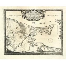
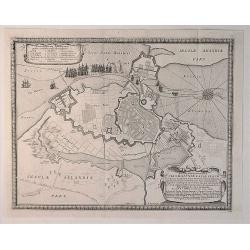
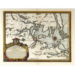
Situs locorum circa neoburgum in Fionia
From Pufendorf's famous chronicle on the Baltic area, ' Histoire du règne de Charles Gustave, roy de Suède'A map of Nyborg and vincinity on the island of Funen.
Date: Nürnberg, C. Riegel, 1697
Selling price: ????
Please login to see price!
Sold in 2010
Delineatio Geometrica Urbis Haffniae Daniae Regnum.
From Pufendorf's famous chronicle on the Baltic area, ' Histoire du règne de Charles Gustave, roy de Suède'
Date: Nürnberg, C. Riegel, 1697
Selling price: ????
Please login to see price!
Sold
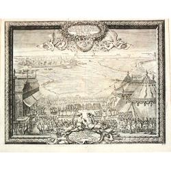
Neoburgum Fioniae oppidum. . .
Decorative plan and panoramic view of the town of Nyborg in Denmark at the coast of Baltic Sea in Fyn. Prepared by Count Erik Jönsson Dahlberg[h] (1625-1703). Military e...
Date: Stockholm, 1697
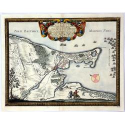
Nackschouia Lalandia Oppidium.
Old map of the Nakskov area of Denmark - Nakscoviae - by Pufendorf/ Dahlberg 1697. It is in Lolland municipality in Region Sjælland on the western coast of the island of...
Date: Sweden, 1697
Selling price: ????
Please login to see price!
Sold in 2017
Ichnogrphia Nakscoviae.
Fine decorative map from Samuel Pufendorfs large description of the Swedish King Karl X Gustav's campaign in Poland, Germany and Denmark in the years 1655-1660. Erik Dahl...
Date: Sweden, 1697
Selling price: ????
Please login to see price!
Sold in 2018
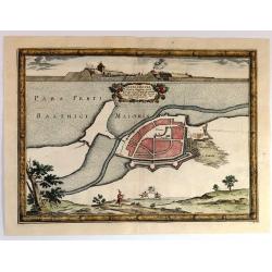
Ichnographia Rutcopiae Langelandice Oppidi
A beautifully engraved plan of the fortified town of Rutkioping on the Danish island of Langeland. Fully engraved sea with two large rowboats filled with sailors engaged ...
Date: Stockholm, 1697
Selling price: ????
Please login to see price!
Sold in 2018
Nackschovia lulandiae Oppidum
A beautiful engraved plan of the fortified town of Nakskov Lolland Island in Demnark. Engraved on copper with a view of the fortress. With a floral title cartouche and pi...
Date: Stockholm, 1697
Selling price: ????
Please login to see price!
Sold in 2016
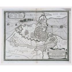
Situs Iocorum Circa Neoburgum in Fiona
A beautiful engraved plan of Nybirg Fyn in Demnark. Engraved on copper with a view of two men on horseback. With a decorative title cartouche and picture frame borders. A...
Date: Stockholm, 1697
Selling price: ????
Please login to see price!
Sold in 2018
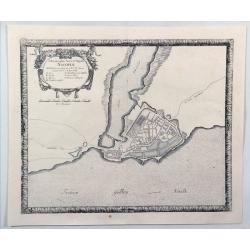
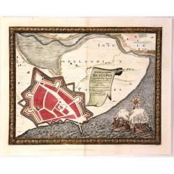
Accurata Delineatio Geometrica in Luthia Friderici Oddae
A striking map of Fredericia in Demnark. Engraved on copper with a view of three ships in the sea. With a decorative drapery title cartouche and picture frame borders. A...
Date: Stockholm, 1697
Selling price: ????
Please login to see price!
Sold in 2018
Regni Daniae Novissima et Accuratissima Tabula.
An uncommon issue of the magnificent map of all of Denmark and the tip of Sweden. The land is fully engraved with mountains, forests and cities, while the sea is filled w...
Date: Amsterdam 1698
Selling price: ????
Please login to see price!
Sold
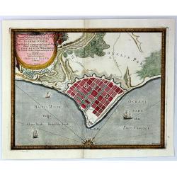
COPENHAGUE Ville Capitale du Royaume de Dannemarq...
Very detailed plan of Copenhagen with a letter key (A-F) identifying important buildings. Shows the city and surrounding area with great detail such as the fortifications...
Date: Paris, 1700
Selling price: ????
Please login to see price!
Sold in 2010
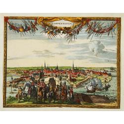
Coppenhaven.
Attractive view of the city and the port of Copenhagen. Very decorative title cartouche on the upper part.
Date: Amsterdam 1702
Selling price: ????
Please login to see price!
Sold
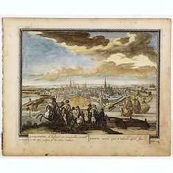
Koppenhaven, de hooftsadt van Denemarken. .
Nice panoramic view of Copenhagen. From Schenk's "Hecatompolis sive Totius Terrarum Oppida Nobiliora Centrum...", a collection of 100 views, dedicated to the 14...
Date: Amsterdam, 1702
Selling price: ????
Please login to see price!
Sold in 2016
Copenhague ...
Charming bird's-eye plan of the fortification of the city of Copenhagen.Nicolas de Fer held the title of Geographer at Louis XIV's court. He was one of the most prolific ...
Date: Paris, 1705
Selling price: ????
Please login to see price!
Sold in 2011
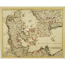
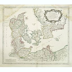
Le Royaume de Danemark subdivisé en ses Principales Provinces..
Handsome map of Denmark and part of Sweden. The map is extremely detailed with rivers, forests, cities and villages. The map is adorned with a striking cartouche flanked ...
Date: Paris, 1709
Selling price: ????
Please login to see price!
Sold in 2008
Carte du Royaume de Danemarc
Detailed map of Denmark, also including southern Sweden and northern Germany, showing the city of Copenhagen (Copenhague).
Date: Paris, 1710
Selling price: ????
Please login to see price!
Sold in 2010
Carte du Royaume de Danemarc.
Guillaume de l'Isle's (1675-1726) well deserved reputation as one of the foremost geographers of the 18th century meant that his maps were influential for many years afte...
Date: Paris, 1710
Selling price: ????
Please login to see price!
Sold in 2022
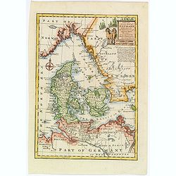
Regni Daniae accuratissima delineatio.
A delightful, attractive small map of Denmark by Philipp Cluver, published in the early years of the eighteenth century. The map has nice, eye catching coloring, enhanced...
Date: London, 1711
Selling price: ????
Please login to see price!
Sold in 2018
Le Royaume de Danemark Avec Une Partie de la Suede.
A detailed map of Denmark and southwestern Sweden, published by Van der Aa in his “Le Nouveau Theatre du Monde . . . .” This bold map of Denmark and southern Sweden s...
Date: Leiden, 1713
Selling price: ????
Please login to see price!
Sold in 2018
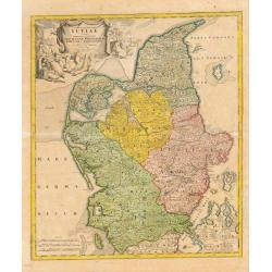
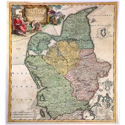
Tabula Generalis Jutiae.
Johan Baptist Homann (1663-1724). Outstanding German cartographer. Founder of the Homann publishing house. After the death of the son Johann Christoph, the firm continued...
Date: Nurnberg, 1714
Selling price: ????
Please login to see price!
Sold
Nouvelle Carte Geographique du Royaume de Dannemarck avec une Table des Villes les Plus Remarquables.
An impressive engraving from Chatelain’s celebrated encyclopedia, “Atlas Historique”. This is a lovely impression of Chatelain’s large map of Denmark. The map cov...
Date: Amsterdam, 1714
Selling price: ????
Please login to see price!
Sold in 2017
Paskaart vande West Kust van Jutland Van Busem tot aen 't Jutlandsche Riff.
A fine chart of the west coast of Schleswig-Holstein with the North Frisian Islands, Pelworm to Sylt and the west coast of Jutland. With a very large title-cartouche.From...
Date: Amsterdam 1715
Selling price: ????
Please login to see price!
Sold
Paskaart van t' Schager-Rak Soo 't by de Oost-vaerende Zee Luyden gemeenlyk bezylt wordt.
The successful van Keulen firm published charts, pilot guides and sea-atlases for over 2 centuries. Founded by Johannes van Keulen, his son Gerard led the firm to its zen...
Date: Amsterdam, 1715
Selling price: ????
Please login to see price!
Sold
Der Nordischen Konigreiche Sud-West Theil.
An attractive map of the southwest portion of the Nordic kingdom, showing southern Sweden and Denmark, a tiny tip of southern Norway, plus some of the northern German and...
Date: Augsberg, 1716
Selling price: ????
Please login to see price!
Sold in 2021
Carte de l'Etat du Royaume de Dannemarck...
Views of the Kingdom of Denmark and various observations about the history and government of this Kingdom.The map shows three views: Friderichsbourg, Copenhagen and Berge...
Date: Amsterdam, 1718
Selling price: ????
Please login to see price!
Sold in 2017
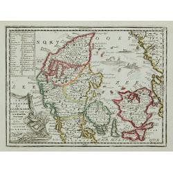
Le Royaume de Danemark Subdivisée en ses quatre Dioceses..
Lovely small map of Denmark, with decorative title cartouche.It shows a text table in the upper left corner containing the names of local rulers.From Le Nouveau et Curieu...
Date: Paris 1719
Selling price: ????
Please login to see price!
Sold
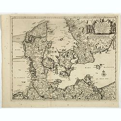
Le Royaume de Danemark Subdivisée en ses quatre Dioceses ...
Lovely small map of Denmark, with decorative title cartouche.It shows a text table in the upper left corner containing the names of local rulers.From Le Nouveau et Curieu...
Date: Paris, 1719
Selling price: ????
Please login to see price!
Sold in 2011
A New Map of the Kingdom of Denmark with the Dutchy of Holstein & c. According to the Newest Observations. . .
A finely detailed map of Denmark with lower Sweden by John Senex. Shows the rivers, marshes, lakes, cities, villages and mountains of the region. A beautiful, illustrated...
Date: London, 1719
Selling price: ????
Please login to see price!
Sold in 2010
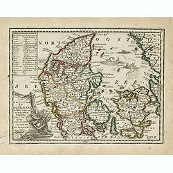
Le Royaume de Danemark Subdivisée en ses quatre Dioceses..
Lovely small map of Denmark, with decorative title cartouche.It shows a text table in the upper left corner containing the names of local rulers.From Le Nouveau et Curieu...
Date: Paris, 1719
Selling price: ????
Please login to see price!
Sold in 2015
Le Royaume de Danermark . . .
Decorative map of Denmark. This well executed engraving was published in 1729 and 1727 by Pieter van der AA, in Leiden in "Les Voyages tres-curieux et tres-renommez ...
Date: Leiden, 1719
Selling price: ????
Please login to see price!
Sold in 2019
Nouvelle Carte Geographique du Royaume de Dannemarck avec une table des villes les plus remarquables.
Map of Denmark with a key table to the towns on both sides.Zacharie Chatelain (d.1723) was the father of Henri Abraham (1684-1743) and Zacharie Junior (1690-1754).They wo...
Date: Amsterdam, ca. 1720
Selling price: ????
Please login to see price!
Sold
Nouvelle Carte Geographique du Royaume de Dannemarck avec une table des villes les plus remarquables.
Map of Denmark with a key table to the towns on both sides.Zacharie Chatelain (d.1723) was the father of Henri Abraham (1684-1743) and Zacharie Junior (1690-1754).They wo...
Date: Amsterdam, ca. 1720
Selling price: ????
Please login to see price!
Sold in 2011
Tabula Generalis Iutiae.
A spectacular and historically important map of the northern part of Denmark, that is called Jutland.It features a wonderful, oversized, decorative drape title cartouche ...
Date: Nuremberg, 1720
Selling price: ????
Please login to see price!
Sold in 2018
Accurate Vorstellung der Beruhmten Enge Zwischen der Nord und Ost See dur Sund Genant. . .Copenhagen. . .
A striking and a lovely copper engraved map of Copenhagen and the sound of Sund from Johann Bapt. Homann's "Grosser Atlas.", with original color to map, the vig...
Date: Nuremberg, ca 1720
Selling price: ????
Please login to see price!
Sold in 2019
Le Royaume de Danemark divise en ses Provinces. . .
This bold, striking map of Denmark and southern Sweden is engraved to highlight marshes, rivers, cities and towns, shoals and forests. The map is decorated with beautiful...
Date: Amsterdam, ca 1720
Selling price: ????
Please login to see price!
Sold in 2019
Regni Daniae- in quo sunt Ducatus Holsatia et Slesvicum Insulae Danicae provinciae Iutia Scania Bleringia.
Original hand-colored engraved map. (sheet size 53 x 62 cm.)
Date: Nuremberg, 1720
Selling price: ????
Please login to see price!
Sold in 2020
Copenhagen
This map by Johann Homann depicts the city of Copenhagen and its environs from differing perspectives, as the city appeared in the early 18th century.There is evidence of...
Date: Nuremberg, 1720
Selling price: ????
Please login to see price!
Sold in 2023
Daniae cum Serie Insularum?
Uncommon map of Denmark. The originally colored title cartouche is surrounded by mythological figures. From Atlas Portatif.
Date: Nuremberg 1724
Selling price: ????
Please login to see price!
Sold
Dania Jutia Holsatia, Scandia...
An attractive map of Denmark and adjacent coastlines. Includes elaborate cartouche and 2 coats of arms.Nice old coloring, drawn and engraved by Michael Kauffer.(inscripti...
Date: Nuremberg, 1724
Selling price: ????
Please login to see price!
Sold in 2012
Daniae Regnum.
No text on verso.
Date: Nuremberg 1730
Selling price: ????
Please login to see price!
Sold
Accurate Vorstellung der Beruhmten... der Königlich Dähnischen..
A map of the Sond between Sweden and Denmark and its approach into Copenhagen. With a bird's eye-view of the Danish capital at the bottom.Surrounding the map are three in...
Date: Nuremberg , ca. 1730
Selling price: ????
Please login to see price!
Sold
Daniae Regnum cum Ducatu Holstiae et Slesvici.
Fine copper engraved map, hand-colored in outline & wash, featuring Denmark, with its neighbouring counties around the Baltic Sea and Schagerack. Map has a decorative...
Date: Augsburg, 1730
Selling price: ????
Please login to see price!
Sold in 2013
Accurate Vorstellung der Beruhmten ? der Königlich Dähnischen ?
A map of the Sond between Sweden and Denmark and its approach into Copenhagen. With a bird's eye-view of the Danish capital at the bottom.Surrounding the map are three in...
Date: Nuremberg , ca. 1730
Selling price: ????
Please login to see price!
Sold in 2009
Daniae Regnum cum Ducatu Holsatiae et Slevici. . .
A decorative and detailed map of Denmark, enhanced by a lovely title cartouche in the top right corner, contains the Danish coat of arms, animals, cherubs and the bounty ...
Date: Nuremberg, 1730
Selling price: ????
Please login to see price!
Sold in 2020
Regni Daniae in que sunt. . .
A nice colored map of Denmark, Schleswig-Holstein and Mecklenburg in Germany, extending from Hamburg in the south to southern Sweden in the north. Embellished with an att...
Date: Nurnberg, ca 1730
Selling price: ????
Please login to see price!
Sold in 2021
Regni Daniae in quo sunt. . .
A beautifully detailed c. 1730 J. B. Homann map of Denmark, that depicts both the Danish peninsular together with some parts of northern Germany and southern Sweden. The ...
Date: Nuremberg, 1730
Selling price: ????
Please login to see price!
Sold in 2021
Regno Di Danimarca.
A fine map of Denmark from "Atlante Novissimo Che Contiene Tutte Le Parti Del Mondo...." This atlas was published in Venice, and was based on the work of Isaak ...
Date: Venice, 1740
Selling price: ????
Please login to see price!
Sold in 2019
Carta Nuova del Regno di Danimarca.
A very pleasing map of Denmark that includes both Schleswig and Holstein, however, these regions are part of modern Germany today. Included in "Atlante Novissimo che...
Date: Venice, 1740
Selling price: ????
Please login to see price!
Sold in 2018
Le Royaume de Danemark Subdivisé en ses Principales Provinces...
A very attractive map of Denmark. From Schenk’s atlas “Contractus sive Mapparum Geographicarum Sansoniarum auctarum et correctarum Nova Congeries” published in Amst...
Date: Amsterdam, 1740
Selling price: ????
Please login to see price!
Sold in 2018
Carta Nuovo del Regno di Danimarca.
A detailed map of Denmark and the southern part of Sweden. With title in block style.The map appeared in "Novissimo Atlas published by Giovanni Albrizzi, a work base...
Date: Venice, 1740
Selling price: ????
Please login to see price!
Sold in 2021
Regni Daniae in quo funt ducatus holsatia et slesvicum insulae danicae provinciae Iutia scania blekingia nova tabula
Denmark by Homann
Date: Nurnberg, 1742
Selling price: ????
Please login to see price!
Sold in 2010
Regni Daniae, in quo sunt Ducatus Holsatia..
Johann Baptist Homann's well-engraved map of Denmark, Schleswig-Holstein and Mecklenburg in Germany. With fine decorative title cartouche.Johann Baptist Homann (1663-1724...
Date: Neurenberg 1744
Selling price: ????
Please login to see price!
Sold in 2009
Dania Regnum In quo sunt Ducatus Holsatia et Slesvicum Iutia, et Insule, dictae Danicae. . .
An attractive map centered on Denmark and including southern tip of Sweden. Very ornamented title cartouche in the upper right-hand corner.Originally published by Frederi...
Date: Amsterdam c. 1744
Selling price: ????
Please login to see price!
Sold in 2015
Regni Daniae.
Johann Baptist Homann's well-engraved map of Denmark, Schleswig-Holstein and Mecklenburg in Germany. With a fine decorative title cartouche featuring animals and two men ...
Date: Nuremberg, 1744
Selling price: ????
Please login to see price!
Sold in 2018
Carte Du Royaume De Danemarc..
Beautifully engraved, highly decorative map showing all of Denmark and southern Sweden, extending north to Warberg.The map is from a Dutch edition of De L'Isle's work ent...
Date: Amsterdam c. 1745
Selling price: ????
Please login to see price!
Sold
Carte Du Royaume de Danemarc.
Beautifully engraved, highly decorative map showing all of Denmark and southern Sweden, extending north to Warberg.The map is from a Dutch edition of De L'Isle's work ent...
Date: Amsterdam, c. 1745
Selling price: ????
Please login to see price!
Sold in 2011
Carte Du Royaume De Danemarc.
A beautifully engraved, highly decorative map showing all of Denmark and southern Sweden, extending north to Warberg, with excellent map detail throughout. Major cities a...
Date: Amsterdam, ca 1745
Selling price: ????
Please login to see price!
Sold in 2020

Vue du Chateau Royal de Frederichsberg Vers la Cour.
A striking view of Fredericksberg Castle in Copenhagen. From "Den Danske Vitruvius", a richly illustrated 18th-century architectural work on Danish monumental b...
Date: Germany, 1746
Selling price: ????
Please login to see price!
Sold in 2020
A New and Accurate map of Denmark.
This is the beautiful 1747 map of Denmark by the British cartographer Emanuel Bowen. It covers all of Jutland and the islands of Zealand, Funen and Lolland. Parts of sout...
Date: London, 1747
Selling price: ????
Please login to see price!
Sold in 2020
Royaume de Danemark.
Detailed map of Denmark, centered on Själland. Showing also the southernmost tip of the Scandinavian peninsula, Scania. Dated 1748.From Atlas Portatif Universel, by Robe...
Date: Paris, 1748
Selling price: ????
Please login to see price!
Sold
Nieuwe Kaart van het Koninkryk van Deenemarken. 1734.
Izaak Tirion (d. 1769) Amsterdam publisher. His ' Nieuwe en beknopte handatlas' saw 6 editions between before 1740 and after 1784. Also ' Tegenwoordige staat van alle vol...
Date: Amsterdam, c. 1750
Selling price: ????
Please login to see price!
Sold
Nieuwe Kaart van het Koninkryk van Deenemarken. 1734
Izaak Tirion (d. 1769) Amsterdam publisher. His ' Nieuwe en beknopte handatlas' saw 6 editions between before 1740 and after 1784. Also ' Tegenwoordige staat van alle vol...
Date: Amsterdam, c. 1750
Selling price: ????
Please login to see price!
Sold
Royaume de Danemark. . .
Detailed map of Denmark, including the Baltic Sea and part of Sweden. Showing towns, rivers, mountains, ports, islands, etc. Large title cartouche, with erased date and p...
Date: Paris, c.1750
Selling price: ????
Please login to see price!
Sold in 2013
Royaume de Danemarck
Lovely map of Denmark that includes Schleswig-Holstein, the Pomeranian coast and Southern Sweden. Includes a fancy ribboned title cartouche.Gilles Robert de Vaugondy (168...
Date: Paris, 1750
Selling price: ????
Please login to see price!
Sold in 2014
