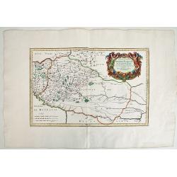
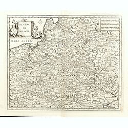
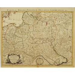
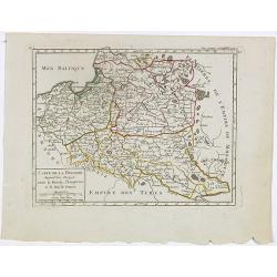
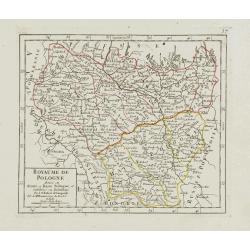
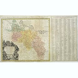
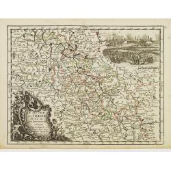
BASSE PODOLIE ou PALATINAT DE BRACLAW ,tiré de la Grande Ukraine de S. le Vasseur de Beauplan.
Fine map of Podolia ,a region actually in North West Ukraine ,but that time territory of Poland Confederation. This map by Robert ( de Vaugondy ) has been based in the pr...
Date: Paris, 1730
Selling price: ????
Please login to see price!
Sold in 2019
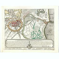
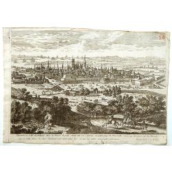
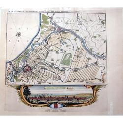
Plan de la Ville, Faubourg et environs de Dantzick, dédié et présenté à la Reine. (Gdansk )
Decorative and rare plan of Gdansk and the castle Weichselmunde by Jean de Beaurain (1696-1771). With a dedication to Marie Leszczynska (Queen of France). At the bottom o...
Date: Paris, 1732
Selling price: ????
Please login to see price!
Sold in 2020
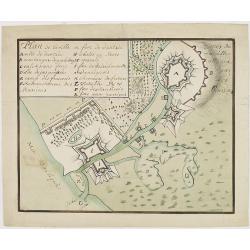
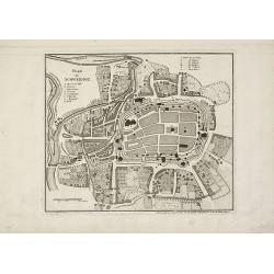
Plan de la ville er fort de Dantzie.
A charming manuscript town-plan of Dantzig, showing the siege of 1734, with a lettered key in upper left corner. The French (E), Russian (F) and Danish (P) positions are ...
Date: Circa, 1734
Selling price: ????
Please login to see price!
Sold in 2013
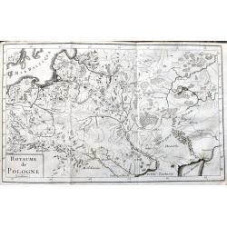
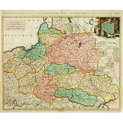
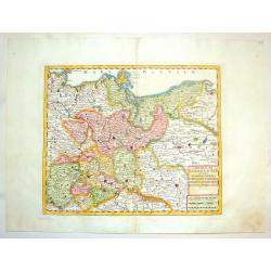
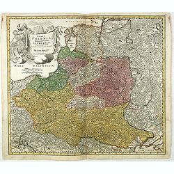
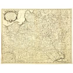
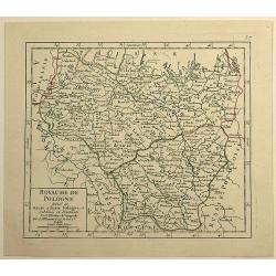
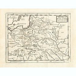
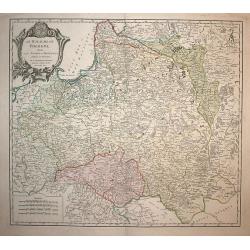
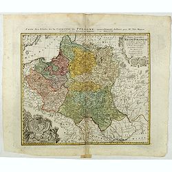
Royaume de Pologne
Rare copper engraved map of Poland, including parts of Lithuania, Latvia, Belarus and the Ukraine. It shows the area from Wroclaw until Moscow and the Black Sea. Names re...
Date: Paris, 1734
Selling price: ????
Please login to see price!
Sold in 2021
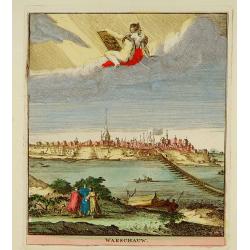
Warschauw
Attractive panoramic view of Warschau and published in the rare first edition of Kleyne en Beknopte Atlas, of Tooneel des Oorlogs in Europa.. .The atlas was published by ...
Date: Amsterdam, 1735
Selling price: ????
Please login to see price!
Sold

Wratislavia Antiquissima et Celeberrima Ducat. Silesiaci Metropolis ... / Breslau due Uhralte u Hochberuhmte Haupt Statt des Herzogth. Schleisien.
Large, old colored engraved town-plan of Wroclaw by Matthaus Seutter. The overall perspective plan with determination of individual buildings as well as detailed explanat...
Date: Augsburg, 1735
Selling price: ????
Please login to see price!
Sold
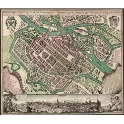
Wratislavia Antiquissima et Celeberrima Ducat. Silesiaci Metropolis ... / Breslau due Uhralte u Hochberuhmte Haupt Statt des Herzogth. Schleisien.
Large, old colored engraved town-plan of Wroclaw by Matthaus Seutter. The overall perspective plan with determination of individual buildings as well as detailed explanat...
Date: Augsburg, 1735
Selling price: ????
Please login to see price!
Sold in 2015
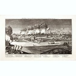
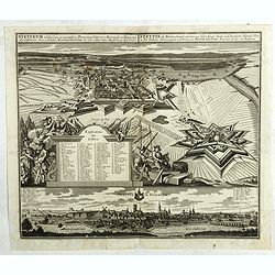
Danzig, im Prospect der Weichselseite unter der russisch-sächsischen Belagerung 1734.
Fine engraving of the Russian and Saksonian siege of Danzig in 1734. With a burning town and a numbered key (1-30) below.Engraved by Georg Paul Busch after Daniel Schultz...
Date: Cologne, H.P. Merian, 1735
Selling price: ????
Please login to see price!
Sold in 2014
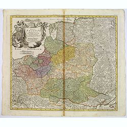
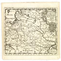
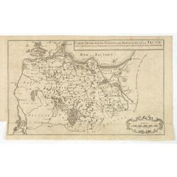
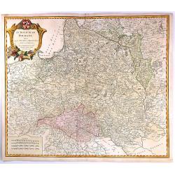
Les Etats de la couronne de Pologne. . .
Rare 1736 edition of De Fer's map of Poland, Lithuania and the Ukraine.The map is bounded by the Baltic, Muscovy, the Dniester and the Oder Rivers and extends to the Pala...
Date: Paris, 1736
Selling price: ????
Please login to see price!
Sold in 2011
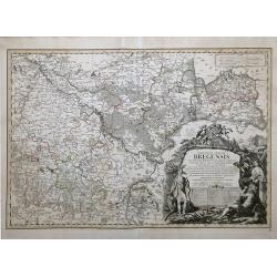
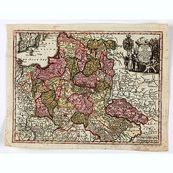
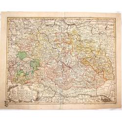
PRINCIPATUS SILESIAE BREGENSIS exactissima Tabula Geographica exhibens Circulos BRIEG, OHLAU, STREHLEN, NIMBTSCH, CREUTZBURG et PITSCHEN. . .
Map done during the reign of Karl VI (1711–1740), and a detailed survey of Silesia that was undertaken by the engineer Lieutenant Johann Wolfgang Wieland, which was com...
Date: Nuremberg, 1736
Selling price: ????
Please login to see price!
Sold in 2020
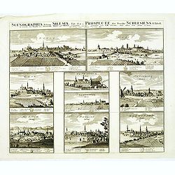
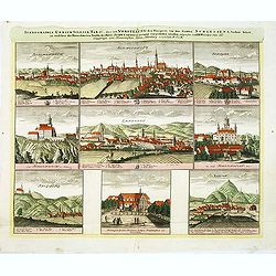
Scenographia Urbium Silesiae, Tab I. / Prospect der Stadte Schlesiens I. Tabell. . . Oels und Brieg. . .
Eight panoramic town-views of Oels and Brieg on one sheet. After a design by the Prussian artist Friedrich Bernhard Werner (1690-1778) and published by Homann's heirs. Un...
Date: Nuremberg, c. 1738
Selling price: ????
Please login to see price!
Sold in 2012
Scenographia Urbium Silesiae, Tab III. / Prospect der Stadte Schlesiens III. Tabell. . . Fürstenth Wohlau. . .
Seven panoramic town-views of Wohlau on one sheet. After a design by the Prussian artist Friedrich Bernhard Werner (1690-1778) and published by Homann's heirs. Underneath...
Date: Nuremberg, c. 1738
Selling price: ????
Please login to see price!
Sold in 2012
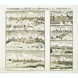
Scenographia Urbium Silesiae, Tab II. / Prospect der Stadte Schlesiens II. Tabell. . . Breslaw und Sagan. . .
Seven panoramic town-views of Breslau and Sagan on one sheet. After a design by the Prussian artist Friedrich Bernhard Werner (1690-1778) and published by Homann's heirs....
Date: Nuremberg, c. 1738
Selling price: ????
Please login to see price!
Sold in 2012
Scenographia Urbium Silesiae, Tab IV. / Prospect der Stadte Schlesiens Vierte Tabell. . . Neise. . .
Eight panoramic town-views of Neise on one sheet. After a design by the Prussian artist Friedrich Bernhard Werner (1690-1778) and published by Homann's heirs. Underneath ...
Date: Nuremberg, c. 1738
Selling price: ????
Please login to see price!
Sold in 2012
Scenographia Urbium Silesiae, Tab V. / Vorstellung der Prospecte . . . Liegnitz und Teschen . . .
Seven panoramic town-views of Liegnitz and Teschen on one sheet. After a design by the Prussian artist Friedrich Bernhard Werner (1690-1778) and published by Homann's hei...
Date: Nuremberg, c. 1738
Selling price: ????
Please login to see price!
Sold in 2012
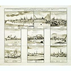
Scenographia Urbium Silesiae, Tab IV. / Prospect der Stadte Schlesiens Sechste Tabell. . . Schweidnitz. . .
Eight panoramic town-views of Schweidnitz on one sheet. After a design by the Prussian artist Friedrich Bernhard Werner (1690-1778) and published by Homann's heirs. Under...
Date: Nuremberg, c. 1738
Selling price: ????
Please login to see price!
Sold in 2012
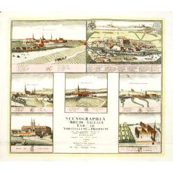
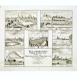
Scenographia Urbium Silesiae, Tab VII. / Vorstellung der Prospecte . . . Munsterb Jaegerend . . .
Seven panoramic town-views of Liegnitz and Munsterb Jaegerend on one sheet. After a design by the Prussian artist Friedrich Bernhard Werner (1690-1778) and published by H...
Date: Nuremberg, c. 1738
Selling price: ????
Please login to see price!
Sold in 2012
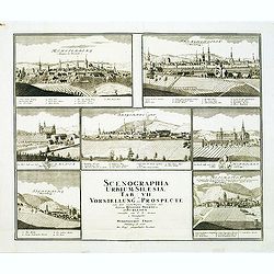
![Scenographia Urbium Silesiae, Tab [V] II. / Vorstellung der Prospecte . . . Munsterb Jaegerend . . .](/uploads/cache/33747-250x250.jpg)
Scenographia Urbium Silesiae, Tab [V] II. / Vorstellung der Prospecte . . . Munsterb Jaegerend . . .
Seven panoramic town-views of Liegnitz and Munsterb Jaegerend on one sheet. After a design by the Prussian artist Friedrich Bernhard Werner (1690-1778) and published by H...
Date: Nuremberg, after 1738
Selling price: ????
Please login to see price!
Sold in 2014
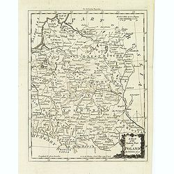
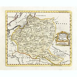
A map of the eastern map of Poland. . .
Drawn by Thomas Kitchin and published in the London Magazine. Cities, towns and geographical features are all shown. Department boundaries within Poland are marked with d...
Date: London, 1739
Selling price: ????
Please login to see price!
Sold in 2012
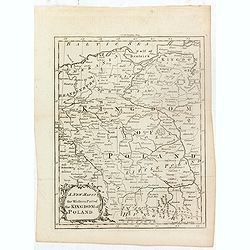
A new map of the western part of the Kingdom of Poland.
Drawn by Thomas Kitchin and published in the London Magazine. Cities, towns and geographical features are all shown. Department boundaries within Poland are marked with d...
Date: London, 1739
Selling price: ????
Please login to see price!
Sold in 2016

Stanislao Leczinski Re di Polonia, Gran Duca di Lituania.
Portrait of Stanislaw I Leszczynski ( 20 October 1677 – 23 February 1766) was King of Poland, Grand Duke of Lithuania, Duke of Lorraine and a count of the Holy Roman Em...
Date: Venice, 1739
Selling price: ????
Please login to see price!
Sold in 2022
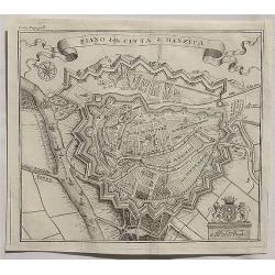
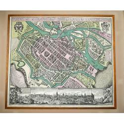
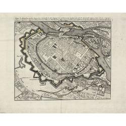
Piano della Citta di Danzica._
A fine copper engraved bird’s eye view shows Gdansk in Poland. From T. Salmon's "Lo stato presente di tutti i paesi e popoli del mondo ...". Published in Ven...
Date: Venice, 1739
Selling price: ????
Please login to see price!
Sold in 2020
Estats de Pologne subdivises suivants les..
Decorative and detailed map of Poland, with tip of the Black Sea lower right. Prepared by Sanson, but published in Amsterdam by Petrus Schenk.
Date: Amsterdam 1740
Selling price: ????
Please login to see price!
Sold
![[Attractive Manuscript Plan of the Village of Prusy (Prauss), Strzelin (Strehlen) County, near Wrocław (Breslau)]](/uploads/cache/35784-250x250.jpg)
[Attractive Manuscript Plan of the Village of Prusy (Prauss), Strzelin (Strehlen) County, near Wrocław (Breslau)]
Attractive manuscript map of the village of Prusy (Prauss), Strzelin (Strehlen) County, near Wrocław (Breslau) and coat of arms of Graf Zierotin - Freiherr von L...
Date: c.1740
Selling price: ????
Please login to see price!
Sold in 2015
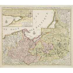
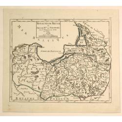
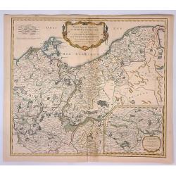
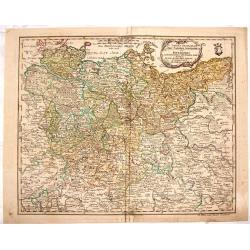
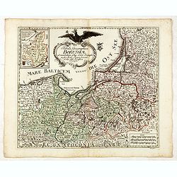
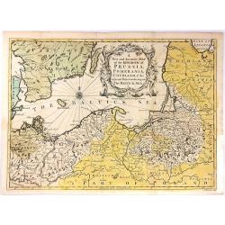
Regni Borussiae.. Royaume de Prusse. . .
Rare map of Prussia, with inset map of the area around Kaliningrad (Koningsberg), the capital of Kaliningrad region, and an exclave of White European Russia, on the Prego...
Date: Amsterdam, 1740
Selling price: ????
Please login to see price!
Sold in 2010
Wratislavia Antiquissima et Celeberrima Ducat. Silesiaci Metropolis ... / Breslau due Uhralte u Hochberuhmte Haupt Statt des Herzogth. Schleisien.
Large, old colored engraved town-plan of Wroclaw by Matthaus Seutter. The plan has great detailed views of individual buildings as well as explanations.In the upper corne...
Date: Augsburg, 1740
Selling price: ????
Please login to see price!
Sold in 2012
Circolo di Sassonia Superiore ovvero Sassonia, Misnia, Voigtland, Turingia, Anhalt, Lusazia, Brandenburg e Pomerania
Interesting copper engraved map featuring the Saxony region of Germany & Poland. Decorated with a block design cartouche. Isaak Tirion (1705-1765) Dutch cartographer...
Date: Amsterdam, 1740
Selling price: ????
Please login to see price!
Sold in 2015
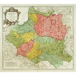
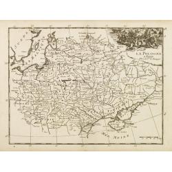
Regno di Polonia.
Detailled map of Poland, Lithuania and the Ukraine. At that time Poland covered the whole of eastern Europe from the Baltic to the Black Sea. There is very good detail th...
Date: Venice, 1740
Selling price: ????
Please login to see price!
Sold in 2015
Regni Poloniae Magnique Ducatus Lithuaniae Nova et exacta tabula ad memtem Starovolcy descripta.
Fine map of Poland and Lithuania, with decorative title cartouche. Johann Baptist Homann born in Kammlach (1663). He was engraver, map-seller and geographer to the Kaiser...
Date: Nuremberg, 1740
Selling price: ????
Please login to see price!
Sold in 2016
Regni Poloniae magnique ducatus Lithuaniae. . .
A fine map of Poland, Lithuania, Latvia, Estonia, and the western part of Russia, with decorative title cartouche.Johann Baptist Homann was born in Kammlach (1663). He wa...
Date: Nurenberg, 1740
Selling price: ????
Please login to see price!
Sold in 2017
Stetinum celeberima et munitissima Pomeranice Citerioris Metropolis . . .
Birds-eye plan view of Stettin in Poland.Matthaus Seutter the elder first published his "Atlas Geographicus" in 1720 and added to the contents in subsequent edi...
Date: Augsburg, ca. 1740
Selling price: ????
Please login to see price!
Sold in 2018
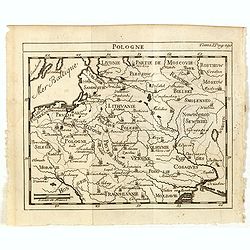
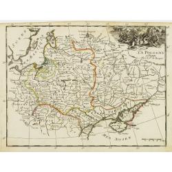
La Pologne.
Fine map of Poland with a battle scene cartouche upper right. From : "Théâtre Général de la Guerre en Europe".G.-L. Le Rouge, who was lieutenant in the regi...
Date: Paris, 1743
Selling price: ????
Please login to see price!
Sold in 2010
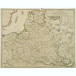
La Pologne dressee sur ce qu'en ont donne Starovolst, Beauplan, Hartnoch..
Large map of Poland, Lithuania, Belarus and part of Ukraine. The map is filled with detail and decorated with a title cartouche flanked by mythological figures. Latin tit...
Date: Amsterdam c. 1744
Selling price: ????
Please login to see price!
Sold
Dantzick Ville de Pologne dans la Prusse Royale.
A very RARE panoramic view of the town of Danzig in Poland.The plate is numbered in red pencil in upper right corner.Engraved by Pierre Aveline (Paris, c.1656 - 23 May 17...
Date: Paris, 1744
Selling price: ????
Please login to see price!
Sold in 2009
Le Royaume de Pologne, Le Grand Duché de Lithuanie suivant les nouvelles Observations.
Rare map of Poland. Le Rouge, who was lieutenant in the regiment of Saxe before establishing himself as publisher, compiler and editor of maps at the rue des Grands Augus...
Date: Paris, 1745
Selling price: ????
Please login to see price!
Sold in 2010
![Die Wahlstadt beij Güntersdorff woselbst des Königs in Preussen Mafestaet den 4ten Junij 1745. . . [Battle of Hohenfriedberg]](/uploads/cache/39375-250x250.jpg)
Die Wahlstadt beij Güntersdorff woselbst des Königs in Preussen Mafestaet den 4ten Junij 1745. . . [Battle of Hohenfriedberg]
A scarce separately issued plan of the Battle of Hohenfriedberg, one of Frederick the Great’s most estimable victories, engraved by the Polish master Bartlomiej Stracho...
Date: Breslau (Wroclaw), Johann Jacob Korn, 1745
Selling price: ????
Please login to see price!
Sold in 2018
Estats de la Couronne de Pologne.
An interesting small map of the Poland by Nicolas de Fer. From Jacques Robbe’s "Methode pour Apprendre Facilement la Geographie". The map has a scale to 20 ho...
Date: Paris,1746
Selling price: ????
Please login to see price!
Sold in 2011
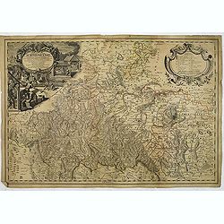
![[2 maps] Novissimum Silesiae Theatrum id est Exactissimus Superioris et Inferioris Silesiae.. (2 maps)](/uploads/cache/21439-250x250.jpg)
[2 maps] Novissimum Silesiae Theatrum id est Exactissimus Superioris et Inferioris Silesiae.. (2 maps)
Impressive, highly detailed map of Silesia adorned with 2 large superb cartouches on 2 opposite corners of the map. The title cartouche is decorated with little angels an...
Date: Amsterdam, c. 1748
Selling price: ????
Please login to see price!
Sold in 2008
Carte de la Pologne. Aujourd'hui Partagée entre la Russie, l'Empereur et le Roi de Prusse.
Small detailed map showing Poland, Lithuania, the Kaliningrad Oblast, Belarus and part of Ukraine.From Atlas Portatif Universel, by Robert de Vaugondy. Page 35 and Tom. P...
Date: Paris, later than 1748
Selling price: ????
Please login to see price!
Sold in 2020
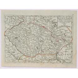
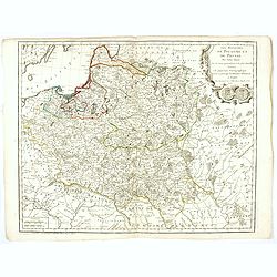
Royaume de Pologne Divisee en Haute et Basse Pologne ...
Fine example of De Vaugondy's map of the Kindgom of Poland, from his “Atlas Portatif. . . ,” first published in Paris in 1748.Gilles Robert de Vaugondy (1688–1766),...
Date: Paris, 1748
Selling price: ????
Please login to see price!
Sold in 2019
Royaume de Prusse et Prusse Rle. ou Ponolaise.
This is a pleasing map of Prussia by Robert de Vaugondy. It covers the northeastern part of Poland and extends from Grodno and the Spirding-See in Poland north to Klaiped...
Date: Paris, 1748
Selling price: ????
Please login to see price!
Sold in 2019
Royaume de Boheme, Marqui de Moravie et Silesie Autrichienne.
A fine 1748 map of Bohemia, Moravia and Silesia by Robert de Vaugondy. It covers modern day Czech Republic as well as parts of Germany and Poland. It extends from Leipzig...
Date: Paris, 1748
Selling price: ????
Please login to see price!
Sold in 2019
Royaume de Pologne divisé en Haute et Basse Pologne..
Small detailed map showing the southern part of Poland. From Atlas Portatif Universel, by Robert de Vaugondy.Unrecorded state with erased date. Page 37 outside border top...
Date: Paris, later than 1749
Selling price: ????
Please login to see price!
Sold in 2017
A New map of Poland from the lastest observe.
Map of Poland, Lithuania. Uncolored copper-engraved map, printed in 1749. No cartographer's name was given, possibly by Senex. Shows the Polish kingdom (including Lithuan...
Date: London, 1749
Selling price: ????
Please login to see price!
Sold in 2015
PLAN EN PROFIL DER BEROEMDE STADT DANTZIG derselver WERDERS, en omleggende Landen,...
SCARCE map of Danzig (Gdansk) in Poland. Superbly engraved and very detailed map of the city and its surroundings, showing small towns with single buildings, fields, woo...
Date: Amsterdam, ca. 1750
Selling price: ????
Please login to see price!
Sold in 2010
Plan de Schweidniz.
A rare plan of Schweidnitz (today Swidnicaat) in Silesia by Le Rouge. Showing the fortified city. With a key from A to H. We only could locate one copy of this plan in th...
Date: Paris, 1750
Selling price: ????
Please login to see price!
Sold in 2015
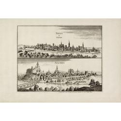
Neiss en Silesia / Teschen.
Very rare city views of Neisse (today Nysa) and Teschen (today Cieszyn) in Silesia after Merian by Le Rouge. Showing the prospects of both cities on one sheet. We only co...
Date: Paris, 1750
Selling price: ????
Please login to see price!
Sold in 2010
Principatus silesiae Schwidnicencis. . .
Detailed map centered on Swidnica, south-west of Breslau (Wroclaw). Published in Atlas Silesiae Id Est Ducatus Silesiae Generaliter Quatuor Mappis Nec Non Specialiter XVI...
Date: Nuremberg, 1750
Selling price: ????
Please login to see price!
Sold in 2011
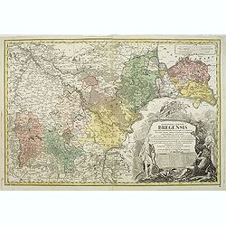
Principatus silesiae Bregensis. . .
Detailed map centered on Brzeg, south east of Breslau (Wroclaw). Published in Atlas Silesiae Id Est Ducatus Silesiae Generaliter Quatuor Mappis Nec Non Specialiter XVI Ma...
Date: Nuremberg, 1750
Selling price: ????
Please login to see price!
Sold in 2011
Principatus Silesiae Wratislaviensis exactissima tabula geographica. . .
Beautiful large scale map of Silesia, centered around Breslau (Wroclaw) with the River Oder. Published in Atlas Silesiae Id Est Ducatus Silesiae Generaliter Quatuor Mappi...
Date: Nuremberg, 1750
Selling price: ????
Please login to see price!
Sold in 2011
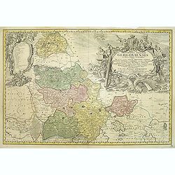
Principatus Silesiae GLOGOVIENSIS novissima Tabula Geographica sistens VI ejusdem Circulos Glogau Freystadt Guhrau Sprottau Grünberg et Schwiebus cum Districtu Polckwitz nee non Liberam Dynastiam Beuthen et Carolath. . .
Detailed map of principality of Grünberg, with an impressive oversized title cartouche depicting the principal coat of arms, gun, spear and game hinting on an area of am...
Date: Nuremberg, 1750
Selling price: ????
Please login to see price!
Sold in 2011
Carte du Diocese de Breslau avec fes IV Arcbidiaco- riats, subdivises en fes cercles archipresbyteriales. . .
Detailed map centered on Breslau (Wroclaw). Beautiful title cartouche in the lower left corner. With a key to the right. Number 4 in left and right lower corners.Publishe...
Date: Nuremberg, 1750
Selling price: ????
Please login to see price!
Sold in 2011
Silesiae Iavoriensis in IV Circulos, Iaver, Hirschberg, Lemberg und Buntzlau divisi ac. . .
Detailed map centered on Jelenia Góra ( Hirschberg), in southwestern Poland. The Sudeten (Sudety) mountains near the Czech border, pictorarily shown.Published in Atlas S...
Date: Nuremberg, 1750
Selling price: ????
Please login to see price!
Sold in 2011
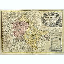
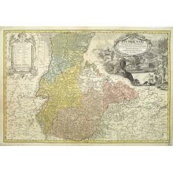
Schlesien Oppeln- 'Principatus Silesiae Oppoliensis exactissima Tabula geographica, sistens Circulos Oppoliensem, Ober-Glogau Gros Strehliz, Cosel, Tost, Rosenberg, Falckenberg & Lubleniz. . .
Detailed map of Southern Poland region of Oppeln. Published in Atlas Silesiae Id Est Ducatus Silesiae Generaliter Quatuor Mappis Nec Non Specialiter XVI Mappis Tot Princi...
Date: Nuremberg 1736 / 1750
Selling price: ????
Please login to see price!
Sold
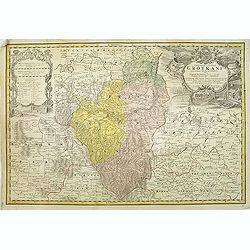
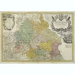
Principatus Silesiae Grotkani exactissima tabula geographica exhibens terram Nissensem simul. . .
Detailed map centered on the region Neisse (Nysa), Grottkau, Ottmachau and Ziegenhals in Poland. Published in Atlas Silesiae Id Est Ducatus Silesiae Generaliter Quatuor M...
Date: Nuremberg, 1736 / 1750
Selling price: ????
Please login to see price!
Sold
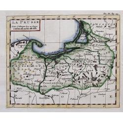
LA PRUSSE.
Interesting small map with parts of today Poland, Kaliningrad Oblast, and Lithuania. Detailed map, includes the cities of Gdansk, Konigsberg (Kaliningrad), Memel (Klaiped...
Date: ca. 1750
Selling price: ????
Please login to see price!
Sold in 2012
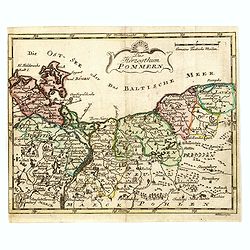
Das Hertzogthum Pommern.
Very rare map of Pomerania engraved by Johann David Schleuen (1711-1771) who was an publisher and engraver active in Berlin. He is known for his "General-Carte des g...
Date: Berlin, ca. 1750
Selling price: ????
Please login to see price!
Sold in 2026
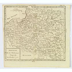
Pologne.
A compact small map of Poland, including Lithuania and Belarus, as they appeared in 1750. Dense detail provided, with topography, place names, rivers and lakes. A nice sm...
Date: Paris, 1750
Selling price: ????
Please login to see price!
Sold in 2019
Poloniae Regnum ut et Magni Ducatus Lithuaniae . . .
Detailed map of Poland and the Baltic regions, extending in the south to Ukraine and northern Hungary.Matthaus Seutter the elder first published his "Atlas Geographi...
Date: Augsburg, 1740-1750
Selling price: ????
Please login to see price!
Sold in 2020
![Carte Generale Inserviente al Teatro della Guerra [...]a Lusazia, la Silesia divisa. . .](/uploads/cache/84695-250x250.jpg)
Carte Generale Inserviente al Teatro della Guerra [...]a Lusazia, la Silesia divisa. . .
A very rare map of the area around Wroclaw and Glatz, extending until Prague, Dresden, and Olomouc. With a title cartouche showing a small view. Further two putti holding...
Date: Venice, ca 1750
Selling price: ????
Please login to see price!
Sold in 2020
Carte generale des Villes et des Bailliages de la Prusse avec une partie de la Pologne et de la Vistule depuis Fantzig jusque à Warsovie.
Scarce map of northern part of Poland, including Gdansk and Warschaw. Engraved by Jacobus van der Schley (1715 - 1779).From "Memoires Pour Servir A L'Histoire De La ...
Date: The Hague, Berlin, Jean Neaulme, 1751
Selling price: ????
Please login to see price!
Sold in 2013
Partie Septentrionale du Cercle de Haute Saxe qui contient le Duche de Pomeranie et le Marquisat de Brandebourg...
A stunning map of the northern portion of Upper Saxony, in what is now northeast Germany and Northwest Poland. It includes the Duchy of Pomerania and Brandenburg, and ext...
Date: Paris, 1751
Selling price: ????
Please login to see price!
Sold in 2018
![Partie septentrionale du cercle de Haute Saxe [...] Brandebourg.](/uploads/cache/44152-250x250.jpg)
Partie septentrionale du cercle de Haute Saxe [...] Brandebourg.
Finely and crisply engraved map of north eastern part of Germany, including part of Poland. With inset map of Brandenburg. Map by Robert De Vaugondy with an ornamental ti...
Date: Paris, ca 1751
Selling price: ????
Please login to see price!
Sold in 2020
Le Royaume de Pologne..
Detailed map of Poland, including Lithuania, Ukraine, East Prussia, etc.
Date: Paris 1752
Selling price: ????
Please login to see price!
Sold
Le Royaume de Pologne,
Detailed map of Poland. The map is filled with towns and topographic details like the river systems. An exquisite cartouche surrounds the title at the top.
Date: Paris, 1752
Selling price: ????
Please login to see price!
Sold in 2008
Pologne.
Scarce small map of Poland based on cartography of Guillaume Delisle (. Published in "Nouveau traité de geographie par M**** ", published by La veuve Lottin &a...
Date: Paris, 1752
Selling price: ????
Please login to see price!
Sold in 2015
Le Royaume de Pologne, divise en ses duches et Provinces, et subdivise en Palatinats
A fine map of the Kingdom of Poland by Vaugondy. It features Poland, Lithuania and parts of the Russian Empire, Transylvania and Latvia. The map details both topographica...
Date: Paris, 1752
Selling price: ????
Please login to see price!
Sold in 2016
Tabula Geographica Circ. Saconiae Superioris et Inferioris.
Fine map featuring Poland and Saxony Germany. From the atlas "Atlas Geographicus Omnes Orbis Terrarum Regiones in XLI Tabulis".CARTOGRAPHER: Leonhard Euler (170...
Date: Berlin, 1753
Selling price: ????
Please login to see price!
Sold in 2015
Tab. Geogr. Circ. Franconiae dimid Saxoniae Superioris.
Fine map featuring part of Poland, Germany and the Czech Republic. From the atlas "Atlas Geographicus Omnes Orbis Terrarum Regiones in XLI Tabulis".CARTOGRAPHER...
Date: Berlin, 1753
Selling price: ????
Please login to see price!
Sold in 2015
Tabula Geographica Borussiae ad emendatiora adhuc edita exempla iussu Acad. Regiae Scient. et eleg. Litt. Borussicae descripta.
Interesting map of Poland with a decorative title cartouche, and a Prussian duty stamp in the higher cartouche as usually for the Euler maps.Engraved by Nikolaus Friedric...
Date: Berlin, Michaelis, 1753
Selling price: ????
Please login to see price!
Sold in 2015
Poland Lithuania and Prussia.
Nice example of Bowen's map of Poland and Lithuania.
Date: London, 1752-1754
Selling price: ????
Please login to see price!
Sold in 2015
La Pologne.
Fine map of Poland. George Louis Le Rouge was active from 1740- till 1780 as a publisher, and was appointed engineer for the King of France. From his Atlas Nouveau Portat...
Date: Paris 1756
Selling price: ????
Please login to see price!
Sold
Le Duché de Silesie..
Fine map of Silesia. With title cartouche and decorative cartouche on upper right corner. George Louis Le Rouge was active from 1740- till 1780 as a publisher, and was ap...
Date: Paris 1756
Selling price: ????
Please login to see price!
Sold
La Pologne.
Fine map of Poland. George Louis Le Rouge was active from 1740- till 1780 as a publisher, and was appointed engineer for the King of France.From his Atlas Nouveau Portati...
Date: Paris, 1756
Selling price: ????
Please login to see price!
Sold in 2008
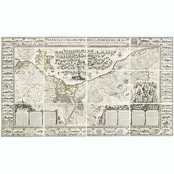
Nova illustrissimi principatus Pomeraniae descrptio.. .
"Only a small number of copies were printed and so this edition is a very rare object today" (Scharfe). THE MOST IMPORTANT EARLY MAP OF POMERANIA, the region on...
Date: Amsterdam, 1618-1757
Selling price: ????
Please login to see price!
Sold in 2015
Plan de Breslau et du Siége de S.M. le R. de Pr. depuis le commencem. iusqu'au 18. de decemb. 1757. jour de la capitul
A rare plan of Breslau (today Wroclaw) during the siege 1757. It shows the day of the capitulation 18. December 1757. Engraved by J.C. Back. With a key below the title.
Date: 1757
Selling price: ????
Please login to see price!
Sold in 2011
Mappa Geographica Regni Poloniae ex novissimis quotquot sunt mappis specialibus composita et al L.L. Stereographicae projectionis revocata a Tob. Mayero. . . .
Decorative map of Poland after Tobias Mayer who was based on Barnikel's map of Curland (1747) and Jan Nieprzecki's map of Lithuania (1749).Poland extends from Glogau and ...
Date: Nuremberg, 1757
Selling price: ????
Please login to see price!
Sold in 2020
A New and Accurate Map of the Kingdom of Prussia,...
A pleasing and a detailed map of the Kingdom of Prussia
Date: London, 1757
Selling price: ????
Please login to see price!
Sold in 2016
Les Royaumes De Pologne Et De Prusse Par Tobias Mayer . . . Chez Daumont . . . 1757
Rare map of Poland, Prussia, Russia and surrounding regions, based upon the map of Tobias Mayer.Published by Jean-Francois Daumont, who was active in Paris between approx...
Date: Paris, 1757
Selling price: ????
Please login to see price!
Sold
![[detail from] Nova illustrissimi principatus Pomeraniae descrptio.. .](/uploads/cache/41152-250x250.jpg)
[detail from] Nova illustrissimi principatus Pomeraniae descrptio.. .
"only a small number of copies were printed and so this edition is a very rare object today" (Scharfe).
Date: Amsterdam, 1618-1757
Selling price: ????
Please login to see price!
Sold in 2018
