Browse Listings in Europe > Netherlands > Holland > Holland maps
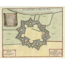
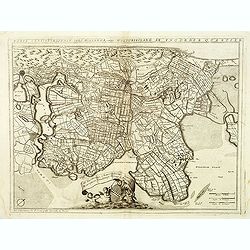
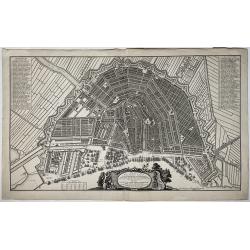
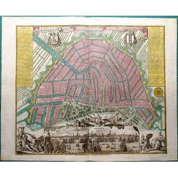
Naerden.
Nice plan of Naarden.
Date: Paris 1696
Selling price: ????
Please login to see price!
Sold
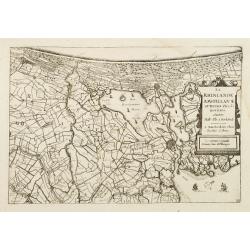
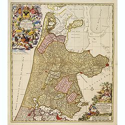
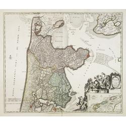
La Rhinlande Amstellande et Terres Circovosines..
Attractive map of the province of Holland, from the atlas "de Vyerighe Colom".
Date: Amsterdam, 1696
Selling price: ????
Please login to see price!
Sold
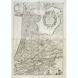
Contado d'Ollanda parte settentrionale / Contado d'ollanda parte meridionale. . .
A beautifully engraved two-sheet map of Holland locating the cities of Leiden, The Hague, Delft, Rotterdam, Breda, Utrecht, Amersfoort, s'Hertogenbosch, etc. The region i...
Date: Venice, ca. 1696
Selling price: ????
Please login to see price!
Sold in 2012
![Contado d'Ollanda parte settentrionale / Contado d'ollanda parte meridionale. . . [two sheet map]](/uploads/cache/34725-250x250.jpg)
Contado d'Ollanda parte settentrionale / Contado d'ollanda parte meridionale. . . [two sheet map]
A beautifully engraved two-sheet map of Holland locating the cities of Leiden, The Hague, Delft, Rotterdam, Breda, Utrecht, Amersfoort, s'Hertogenbosch, etc. The region i...
Date: Venice, ca. 1696
Selling price: ????
Please login to see price!
Sold in 2020
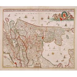
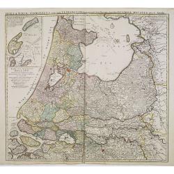
Comitatus Hollandiae tabula pluribus..
West to the top. Lower left inset of the Wadden Islands, Texel, Vlieland, Terschelling and part of Ameland.
Date: Amsterdam 1698
Selling price: ????
Please login to see price!
Sold
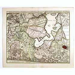
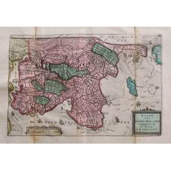
Parte septtentrionale dell' Hollanda, vulgo Westuriesland en Tnoorder Quartier. . .
A beautifully engraved map of northern Netherlands or "West Friesland", including the towns of Amsterdam, Hoorn, Haerlem, t'Huys, Edam, etc. The region is fille...
Date: Venice, 1698
Selling price: ????
Please login to see price!
Sold
Kennemaria et Westfrisia vulgo et vernacule Noord Holland.
A most decorative map, in bright full original colors, of the northern part of Holland. At that time practically all polders -with the exception of the IJ-polder- had alr...
Date: Amsterdam, 1698
Selling price: ????
Please login to see price!
Sold in 2012
Nieuwe Kaerte van t'Baljuwschap van Kennemerland met de Bannen van Westsaanen, Assendelft, Heemskerk . . .
Rare map prepared by Elisabeth Visscher who was the widow of Nicolas Visscher and republished by Petrus Schenk. East to the top. Including Haarlem, Heemskerk, Velsen, etc...
Date: Amsterdam, 1715
Selling price: ????
Please login to see price!
Sold in 2017
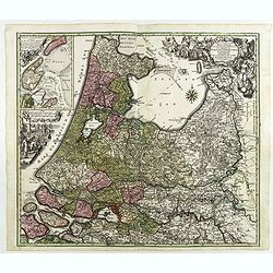
Tabula Comitatus Hollandiae in Praefecturas sua distributa, cui adjuncta est Provinc. Ultraiectina et maxima pars Geldriae summo studio delin. . .
Fine map of the provinces of North and South Holland. In upper left hand corner an inset with the islands of Texel and Vlieland. Just below the inset map a harbour scene ...
Date: Augsburg 1730
Selling price: ????
Please login to see price!
Sold in 2018
Plan de la grande & fameuse ville marchande d'Amsterdam / Plan de la grande & fameuse ville marchande d'Amsterdam
A very large size city map of Amsterdam within its fortifications is seen from the IJ, with main buildings depicted in bird's eye view, and many ships moored or in the ha...
Date: Amsterdam, ca. 1725/1735
Selling price: ????
Please login to see price!
Sold in 2022
Hollandiae Septentrionalis & Frisiae Occidentalis. . .
Map of the Dutch region of North Holland between Amsterdam, Enkhuizen and Texel island. Large figurative cartouche and inset map of the islands Texel, Vlieland and Tersch...
Date: Amsterdam, ca. 1737
Selling price: ????
Please login to see price!
Sold in 2009
Hollandiae comitatus una cum Ultrajectino Dominio nec non maximis partibus Geldriae Ducatus / per C. Specht. . .
Scarce map of the center of the Low Countries, with the provinces North and South Holland in full contemporary body colors, with inset map of Texel and Vlieland in upper ...
Date: Amsterdam, 1740
Selling price: ????
Please login to see price!
Sold in 2020
Kaart van Noord-Holland...
Interesting map of the northern part of the Netherlands. Oriented to the west. It extends from Amsterdam northward as far as Texel and southward as far as Enkhuizen. With...
Date: Amsterdam, c1745
Selling price: ????
Please login to see price!
Sold in 2014
Amsterdam, die weltberuhmte Haupt - und Handel Statt in Holland (..)
A copper engraved map with original hand coloring. Overall size 55 x 68 cm. A beautifully engraved map of Amsterdam, with 2 coat-of-arms, 2 vignettes in the lower corner,...
Date: Augsburg, ca. 1745
Selling price: ????
Please login to see price!
Sold in 2017
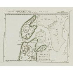
I. Carte du Comté de Hollande où se trouve l'Isle de Texel.
Attractive small map illustrating the northernmost tip of Noord-Holland and Texel. From Atlas Portatif Universel, by Robert de Vaugondy.Unrecorded state with erased date....
Date: Paris, later than 1748
Selling price: ????
Please login to see price!
Sold
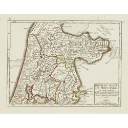
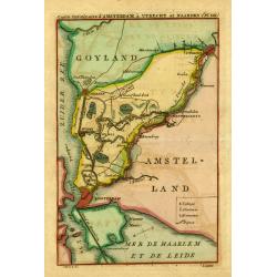
II. Partie du Comté de Hollande.. Edam &c.
Attractive small map illustrating the central part of Noord-Holland, between West Friesland and the IJ bay.From Atlas Portatif Universel, by Robert de Vaugondy. Unrecorde...
Date: Paris, later than 1748
Selling price: ????
Please login to see price!
Sold in 2020
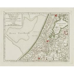
IV. Partie du Comté de Hollande.. Haarlem, Leyden, la Haye..
Attractive small map centered on Zuid Holland, including Leiden, Delft extending northwards as far as Haarlem.From Atlas Portatif Universel, by Robert de Vaugondy. Unreco...
Date: Paris, later than 1748
Selling price: ????
Please login to see price!
Sold in 2017
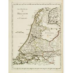
Les Provinces de Hollande et d'Utrecht.
Fine map of Holland and Utrecht. George Louis Le Rouge was active from 1740- till 1780 as a publisher, and was appointed engineer for the King of France. From his Atlas N...
Date: Paris 1756
Selling price: ????
Please login to see price!
Sold

Tabula comitatus Hollandiae. . .
Fine map of the provinces of North and South Holland. In upper left hand corner an inset with the islands of Texel and Vlieland.
Date: Augsburg 1760
Selling price: ????
Please login to see price!
Sold in 2024
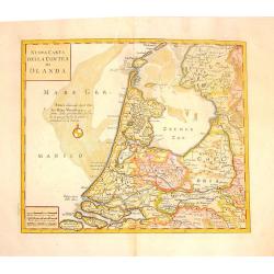
Nuova Carta della Contea de Olanda.
Fine copper engraved map of Holland. Two block cartouches. Giambattista Albrizzi (1698-1777) was a Venetian publisher and journalist. Among books published, was a monume...
Date: venice, 1740-1762
Selling price: ????
Please login to see price!
Sold in 2015
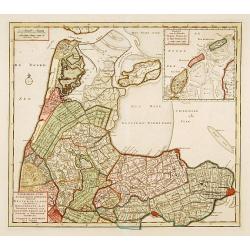
NoordHollands..WestFriesland..Dregterland..Koggen enz.
A very detailed map of North Holland also showing the famous cities Enkhuizen, Hoorn and Alkmaar. With an inset of the islands Texel, Vlieland and Terschelling.
Date: Amsterdam 1769
Selling price: ????
Please login to see price!
Sold
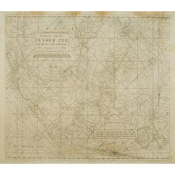
Paskaarte van de Zuyder zee met alle des Zelfs inkoomende Gaaten A° 1771.
Latitude scale, compass rose and system of rhumb lines, soundings, anchorage's, etc. A wealth of cities and information appear in the chart. This is an update of an older...
Date: Amsterdam 1753/1771
Selling price: ????
Please login to see price!
Sold
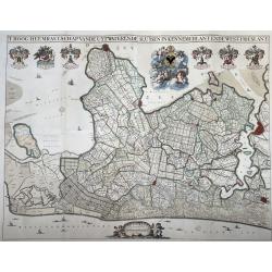
T Hoogh-Heemraetschap van de Uytwaterende Sluysen in Kennemerlant ende West-Frieslant’
A very large format wall map of the province of North Holland made and published for the district water board of Kennemerland and West Friesland, on four leaves, combined...
Date: Amsterdam, 1781
Selling price: ????
Please login to see price!
Sold in 2021
" Carte.. Amsterdam, á Utrecht et Naarden."
Uncommon map showing the road and river Vecht from Amsterdam to Utrecht. Including Naarden, Muiden, Weesp, Loenen, Maarsen, etc.
Date: Amsterdam 1821
Selling price: ????
Please login to see price!
Sold
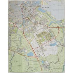
Nederland 1 : 25.000 Blad 25D Amstelveen.
Folding-map of southern part of Amsterdam, Amsterdam Zuid-Oost , Ouderkerk aan de Amstel, Abcoude and part of Amstelveen. First edition in 1977, then corrected in 1981 by...
Date: Netherlands, 1977, revised 1981
Selling price: ????
Please login to see price!
Sold in 2009
