Browse Listings in Europe > Netherlands
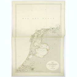
Mar de la Norte, Carta de la Costa de Holanda. . .
A large sea chart, published in Madrid of part of the coast of Holland. The chart extends from Borkum in Lower Saxony in Germany in the north, south to Brouwershaven in Z...
Date: Madrid, 1866
Selling price: ????
Please login to see price!
Sold in 2019
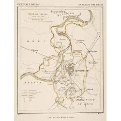
Gemeente Roermond.
From: J.Kuyper Gemeente-Atlas van Nederland naar officieele bronnen bewerkt. He was one of the most important Dutch atlas editors of the second half of the 19th century. ...
Date: Leeuwarden 1867
Selling price: ????
Please login to see price!
Sold in 2025
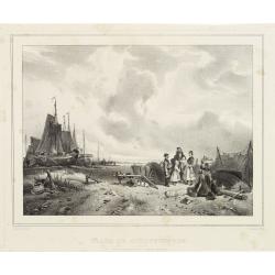
Plage de Scheveningen.
Attractive lithography showing a typical Dutch beach scene at Scheveningen in the middle of the 19th century, lithographed by Cleman after a painting by Nuyen. Published ...
Date: The Hague, c.1867
Selling price: ????
Please login to see price!
Sold
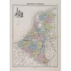
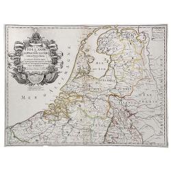
Hollande et Belgique.
A decorative map of Holland and Belgium from Géographie Universelle, Atlas Migeon, published by J. Migeon. With an engraving of the Antwerp Cathedral upper left corner.F...
Date: Paris, 1874
Selling price: ????
Please login to see price!
Sold in 2011
![[ University building Leiden. ]](/uploads/cache/26985-250x250.jpg)
[ University building Leiden. ]
Etching by G.C.Haverkamp (1872-1926) showing the building of Leiden University on the Rapenburg, seen from beyond the canal.Signed with pencil under bottom-right by the a...
Date: Netherlands ca. 1900
Selling price: ????
Please login to see price!
Sold in 2014
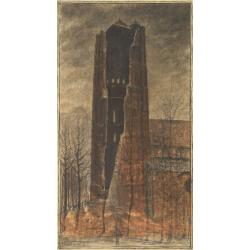
Church of Oirschot after a lightning stroke of 1904.
Fine pastel drawing by Piet Panhuizen of the church of Oirschot after it was hit by a lightning stoke in 1904. Piet Panhuizen was born in Helmond and started as designer ...
Date: Oirschot, 1904
Selling price: ????
Please login to see price!
Sold in 2009
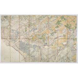
Stafkaart Steenwijk, Kwartblad 2 Schaal 1 : 50.000.
Map of the city of Steenwijk and vicinities of Blokzijl, Wolvega, Diever, Munikeburen, etc… Scale 1 : 50,000.More about folding maps. [+]
Date: Steenwijk, 1904
Selling price: ????
Please login to see price!
Sold in 2013
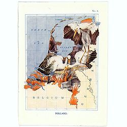
Holland.
A fun and unusual map of Holland, in the shape the Stork story of Deft. Map No.8, in good printed color, shows some cities and towns. Lines of longitude and latitude. Fro...
Date: London, 1912
Selling price: ????
Please login to see price!
Sold in 2017
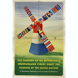
The soldiers of the Netherlands Underground Forces greet the Soldiers of the United Nations.
A poster in English and Dutch designed by Frederick Henri Kay Henrion and printed in lithography right after the liberation. Bi-langual poster: "The soldiers of the ...
Date: Smeets, Weert, 1945
Selling price: ????
Please login to see price!
Sold in 2017
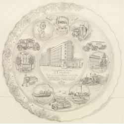
Shell : 9 Februari 1911-1951.
Decorative design-drawing in lead pencil offered to mr. J.E. Talens for his 40 years jubilee at the Shell foundation : Aangeboden aan J. E. Talens ter gelegenheid van zij...
Date: Gouda, ca. 1951
Selling price: ????
Please login to see price!
Sold in 2025
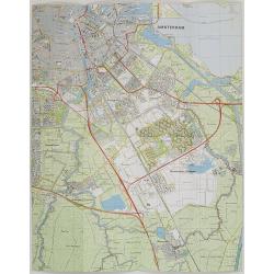
Nederland 1 : 25.000 Blad 25D Amstelveen.
Folding-map of southern part of Amsterdam, Amsterdam Zuid-Oost , Ouderkerk aan de Amstel, Abcoude and part of Amstelveen. First edition in 1977, then corrected in 1981 by...
Date: Netherlands, 1977, revised 1981
Selling price: ????
Please login to see price!
Sold in 2009
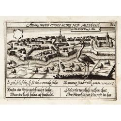
Helmond.
"View of the town with in the foreground a large stork. With a verse in two languages underneath the picture.The poet Daniel Meisner from Komotau started his Thesaur...
Date: Frankfurt 1623-78
Selling price: ????
Please login to see price!
Sold
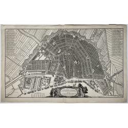
Plan de la grande & fameuse ville marchande d'Amsterdam / Plan de la grande & fameuse ville marchande d'Amsterdam
A very large size city map of Amsterdam within its fortifications is seen from the IJ, with main buildings depicted in bird's eye view, and many ships moored or in the ha...
Date: Amsterdam, ca. 1725/35
Selling price: ????
Please login to see price!
Sold in 2022
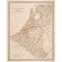
Belgium and Holland, late the Km. of the Netherlands.
"Very detailed map of the Netherlands, Belgium and Luxembourg. Indicated are railways, canals and battlefields by date.James Wyld (the younger) was geographer to the...
Date: London 1855/64
Selling price: ????
Please login to see price!
Sold
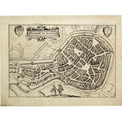
Berge op Zoom.
From Ludovico Guicciardini.'s description of the Netherlands ' Beschrijvinghe van alle de Nederlanden anderssins ghenoemt Neder-Duytslandt ', published by Willem Blaeu.A ...
Date: Amsterdam, W.Blaeu, 1612.
Selling price: ????
Please login to see price!
Sold
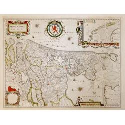
Hollandia Comitatus.
French text verso. Highly detailed regional map of Holland, showing the area around Amsterdam, Utrecht, Rotterdam, with an inset upper right corner of the Dutch Islands o...
Date: Amsterdam, 1647
Selling price: ????
Please login to see price!
Sold in 2016
La Hollande ou les Provinces Unies des Pays Bas.
A copperplate border colored map of Holland. A scarce map of the 7 Provinces as published in Paris by Danet. Includes 7 coats of arms in the title cartouche.
Date: Paris, ca. 1720
Selling price: ????
Please login to see price!
Sold in 2019
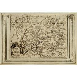
La Frise, suivant les nouvelles observations..
With decorative title cartouche lower left corner.This example is unusual in having the additional separately engraved decorative framework border around the map, the res...
Date: Amsterdam 1728.
Selling price: ????
Please login to see price!
Sold
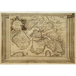
La Zelande, suivant les nouvelles observations..
With decorative title cartouche upper left corner.This example is unusual in having the additional separately engraved decorative framework border around the map, the res...
Date: Amsterdam 1728.
Selling price: ????
Please login to see price!
Sold
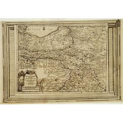
La Gueldre, suivant les nouvelles observations..
With decorative title cartouche lower left corner.This example is unusual in having the additional separately engraved decorative framework border around the map, the res...
Date: Amsterdam 1728.
Selling price: ????
Please login to see price!
Sold
