Browse Listings in Europe > Mediterranean & Islands > Majorca / Minorca
(Balearic Islands: Majorca, Minorca, Ibiza, Formentera)
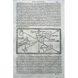
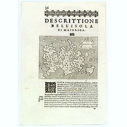
The first separate printed maps of the Balearics, and the first regional map to name "Catalunya" (Catalonia) on the Spanish mainland! A wood cut page with Ital...
Date: Venice, 1528-1547
Selling price: ????
Please login to see price!
Sold in 2015
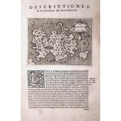
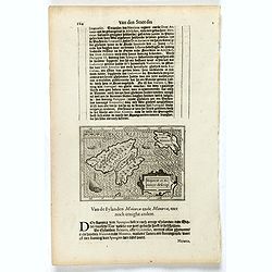
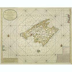
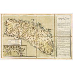
MAIORCA.
One of the earliest separate maps of Majorca (Mallorca)! First issue from 1572. The map shows major cities and several sea monsters. A compass rose orients the map with s...
Date: Venice, c1572
Selling price: ????
Please login to see price!
Sold in 2013
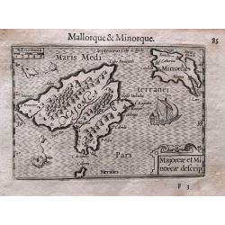
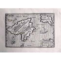
Majorcae et Minorcae descrip.
Superb miniature map of the Balearics. Including a sailing ship, sea monsters, and the title cartouche. With French text on verso.Published in his "Caert-Thresoor&qu...
Date: Amsterdam, c. 1600
Selling price: ????
Please login to see price!
Sold in 2017
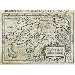
Majorcae et Minorcae descrip.
Superb miniature map of the Balearics. Including a sailing ship, sea monsters, and the title cartouche.Hondius map from Bertius "Tabularum geographicarum"! Rare...
Date: Amsterdam, 1618
Selling price: ????
Please login to see price!
Sold in 2013
Maiorica.
A delightful small map of Majorca, the largest of the Balearic Islands. First published in 1572, this is the later edition of 1620. The place names of Palma, Cala Figera,...
Date: Venice, 1620
Selling price: ????
Please login to see price!
Sold in 2020
Majorcae et Minorcae descrip.
Small map depicting 2 of the Balearic Islands, surrounded by text in Dutch. Embellished with a sailing boat and 2 sea monsters.Nicolaes de Clerck (de Klerc) was active as...
Date: Amsterdam, Cloppenburch, 1621
Selling price: ????
Please login to see price!
Sold in 2016
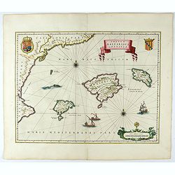
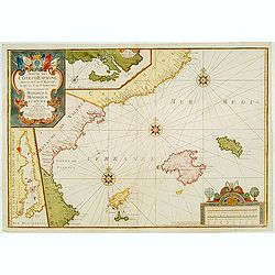
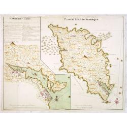
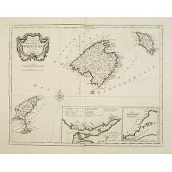
Insulae Balearides et Pytiusae.
A map of Mallorca and Minorca and with Ibiza and Formentera, called the Pytuisae Islands, with the coastline from Barcelona to Denia.From an incomplete example of the 164...
Date: Amsterdam, 1644
Selling price: ????
Please login to see price!
Sold
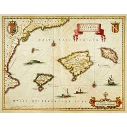
Insulae BALEARIDES et Pytissiae.
A map of Mallorca and Minorca. With Ibiza and Formentera, called the Pytuisae Islands. The coastline runs from Barcelona to Atalaia.
Date: Amsterdam 1639-1644
Selling price: ????
Please login to see price!
Sold
Majorcae et Minorcae descrip.
Superb miniature map of the Balearics. Including a sailing ship, sea monsters, and the title cartouche. After Barent Langenes from his Caert-Thresoor. Very rare and at...
Date: Amsterdam, 1649
Selling price: ????
Please login to see price!
Sold in 2013
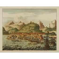
Het veroveren der stadt Allegona in 't eylandt groot Canaria, in den Jaere MDXCIX.
The town Las Palmas on Gran Canaries taken by a Dutch fleet in 1649
Date: Netherlands c.1660
Selling price: ????
Please login to see price!
Sold
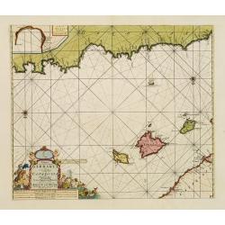
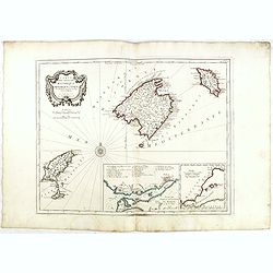
De Custen van Valencia en Catalonia van C. de S. Martyn tot C. Dragonis, als meede de Eylanden van Majorca, Minorca en Yvica.
Important early Dutch sea chart by Goos from his important Atlas Zee-spiegel. Includes the northeastern coast of Spain with Valencia, Tarragona, and Barcelona. With the B...
Date: Amsterdam, ca. 1662
Selling price: ????
Please login to see price!
Sold in 2017
![[Lot of 5 maps of the Iberian peninsula / Belearics]](/uploads/cache/18379-(2)-250x250.jpg)
[Lot of 5 maps of the Iberian peninsula / Belearics]
Guillaume de l' Isle (1675-1724), Royal Geographer, was the most influential cartographer of the first quarter of the 18th century. ' Atlas de Géographie' (1700-12), pos...
Date: 1701
Selling price: ????
Please login to see price!
Sold in 2022
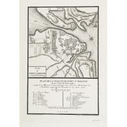
Le port et la ville de Mahon, le Bourg et le Fort St. Philippe..
Map encompassing the area between Mahon fort St. Philippe in Minorca. Wind rose in the upper left corner.Port Mahon is one of the world's finest natural harbors. During t...
Date: Paris, 1705
Selling price: ????
Please login to see price!
Sold in 2008
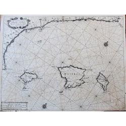
Paskaart, Voor een Gedeelte der Kust van, Barbaria.. Catalonia.. Yvica, Majorca, en Minorca..
This sea chart covers the Algerian coast in front of the Balearic Islands, South on top. Shows the 4 Balearic Islands (Majorca, Minorca, Ibiza) and part of the Catalonian...
Date: Amsterdam, 1708
Selling price: ????
Please login to see price!
Sold
Carte des isles de Maiorque Minorque et d'Yvice..
Map of the Balearic Islands of Mallorca, Menorca and Ibiza with large cartouche and inset plan of the harbour of Mahon and a small overall map of the western Mediterranea...
Date: Augsburg 1720
Selling price: ????
Please login to see price!
Sold
Suitte des Cotes d'Espagne.. avec les Isles de Mayorque Minorque et d'Yvice.
An attractive map centred on the eastern part of Spain. Includes two inset maps of Minorca and Sofa Bay. Decorative title cartouche on the upper left corner. With the men...
Date: France 1723
Selling price: ????
Please login to see price!
Sold
![Carte des isles de Majorque Minorque et Yvice : Dediée A M. le Comte de Maurepas Ministre et Secret[ai]re d'Etat Commandeur des Ordres du Roi / par N. B[ellin] Ingénieur au Dépost des Cartes et Plans de la Marine. .](/uploads/cache/30644-250x250.jpg)
Carte des isles de Majorque Minorque et Yvice : Dediée A M. le Comte de Maurepas Ministre et Secret[ai]re d'Etat Commandeur des Ordres du Roi / par N. B[ellin] Ingénieur au Dépost des Cartes et Plans de la Marine. .
Fine map of the Baleares with Minorca, Majorca, Ibiza. In lower right inset maps of a Plan of the Port of Mahon, and the western Mediterranean (showing the location of th...
Date: Paris, 1740
Selling price: ????
Please login to see price!
Sold in 2022
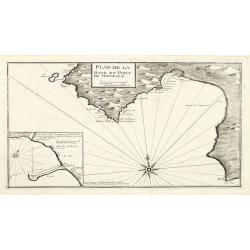
Plan de la Baye et Port de Mayorque. par Jacques Ayrouard pilote real et gravé par Louis Corne.
Large plan of the harbour Majorca. Decorated with a large compass rose.From the rare chart book by Jacques Ayrouard: "Recueil de plusieurs plans des ports et rades e...
Date: Marseille 1732-1746
Selling price: ????
Please login to see price!
Sold in 2010
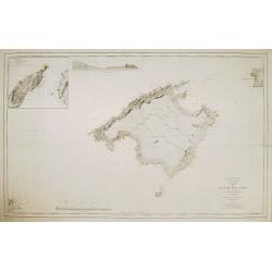
Nieuwe Afteekening van het Eyland Maiorca
So called "Blue-back" sea- of Majorca.Latitude scale, compass rose and system of rhumb lines, soundings, anchorage's, etc. A wealth of cities and information ap...
Date: Amsterdam, 1750
Selling price: ????
Please login to see price!
Sold in 2011
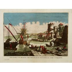
Première vue de l'Isle minorque et d'une partie du Fort St Philippe.
A so-called optical print of the harbour of Majorcal.In the eighteenth and nineteenth centuries there were many popular speciality establishments in Paris, Augsburg and L...
Date: Paris 1750
Selling price: ????
Please login to see price!
Sold
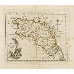
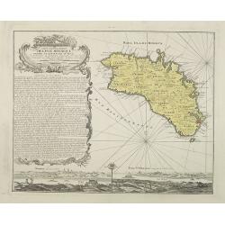
Isle Minorque.
Nice map of the island of Majorca, title cartouche lower left. Orientated to the north.
Date: Paris, 1756
Selling price: ????
Please login to see price!
Sold
Carte welche die Inseln Maiorca, Minorca, Yvica und Formentera..
So called "Einblattdruck" of Majorca, Minorca and 2 insets of parts of the Island Majorca. Prepared after Felßecker and Bellin.
Date: Frankfurt a.Main & Leipzig, dated 1756
Selling price: ????
Please login to see price!
Sold
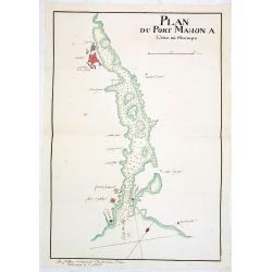
Plan du Port Mahon à l'isle de Minorque.
Uncommon early French manuscript map of the bay and town-planof port Mahón. The entrance of the bay is blocked by "Staccades". St. Philip's Castle still in it ...
Date: Minorca ? / France, ca. 1756
Selling price: ????
Please login to see price!
Sold
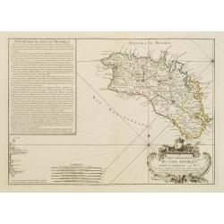
Carte topographique DE L'ISLE MINORQUE, Dédiée et présentée au Roy ..
Very rare map depicting the island of Minorca. The bottom is decorated with a stunning title cartouche, engraved by Choffard.The French text on the left side contains a l...
Date: Paris 1756
Selling price: ????
Please login to see price!
Sold
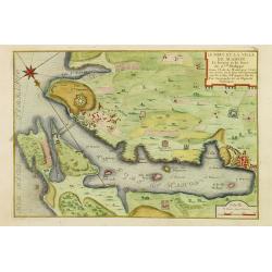
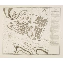
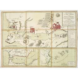
Plan de la Ville et du Port Mahon et du Fort St. Philippe.
Scarce separately issued map of the fort and town St.Philippe and port Mahon in a first state. In upper left corner the title and a key in French (A-Z, Aa-Bb) and a key i...
Date: Paris, ca. 1756
Selling price: ????
Please login to see price!
Sold in 2013
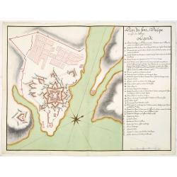
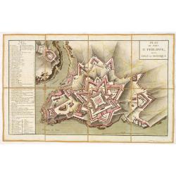
Plan du Fort St. Philippe et de ses Environs : Situés à l'entrée du Port Mahon dans l'Isle de Minorque / Envoyés par Mgr le Marechal Duc de Richelieu. . .
Separately published print of Fort Philippe with numbered key [key: 1-51] to the right. Published on 24 May 1756 by R.J. Julien à l'Hotel de Soubise in Paris. According ...
Date: Paris, ca. 1756
Selling price: ????
Please login to see price!
Sold in 2013
Plan du fort St. Philipe en l'isle de Minorque. . .
Manuscript plan of Fort Philippe with a lettered key [key: A-Z a-h] to the right. This manuscript plan is very similar to the separately published plan by R.J. Julien of...
Date: Paris, ca. 1756
Selling price: ????
Please login to see price!
Sold in 2016
Plan de Lisle de Minorque. / Plan du port Mahon.
Manuscript map of the island of Minorca. The left hand part shows the Bay of Mahon with the town of Mahon and Fort Philippe with a lettered key [A-Z &].The map is fil...
Date: Paris, ca. 1756
Selling price: ????
Please login to see price!
Sold
Carte topographique de l'isle Minorque dediée et presentée au roy par le chevalier de Beaurain. . . et communiquée au public par les Heritiers de Homan en l'an 1757.
A rare map depicting the island of Minorca. The upper left is decorated with a stunning title cartouche.The German text on the left side contains a lengthy description of...
Date: Nuremberg, 1757
Selling price: ????
Please login to see price!
Sold in 2010
Plan de la ville et du fort St. Philippe dans l'Isle de Minorque assiégé le 8 mai par l'armée française aux ordres du Maréchal de Richelieu, occupé par les Français le 29 juin 1756.
A military plan of St. Philip's fortifications and fort on the Island of Minorca. With an inset map of Fort St. Philip with a key : 1-26. The model was made by Therbu. En...
Date: Paris, ca. 1762
Selling price: ????
Please login to see price!
Sold in 2009
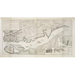
Carte Topographique et Militaire de L'Isle Minorque.
A fine map of Minorca with inset of the Bay of Mahon. With an extensive "Instruction" to the right "ette Carte levée et dessinée par des Officiers de l'A...
Date: Paris, ca. 1770
Selling price: ????
Please login to see price!
Sold in 2013
Plan du fort Saint-Philippe dans L'isle de Minorque.
A military plan of Fort St. Philip with a key to the left, with references to the fortifications de San Carlos (Q) et Malborough (R). In upper right corner "N°.3.&q...
Date: Paris, ca. 1770
Selling price: ????
Please login to see price!
Sold in 2013
Nouveau Plan du port Mahon et du fort St Philipe Avec les Campements et les différentes Attaques des Troupes Françoises et Espagnoles. . .
A fine map of the Bay of Mahon with a key to the right "Remarques et Renvois du Plan". According to the tittle "Levé sur les Lieux Par les Ingénieurs Mil...
Date: Paris, ca. 1782
Selling price: ????
Please login to see price!
Sold in 2013
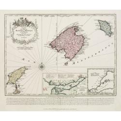
Carte des Isles de Majorque, Minorque, et Yvice..
Decorative map representing the Balearic islands, Minorca, Majorca, Ibiza. With 2 insets and an ornamental title cartouche.Venetian edition of the map by Bellin, to whom ...
Date: Venice, 1776 - 1784
Selling price: ????
Please login to see price!
Sold in 2008
Carte des Isles de Majorque, Minorque, et Yvice. . .
Decorative map representing the Balearic islands. With 2 insets and an ornamental title cartouche.Venetian edition of the map by Bellin, to whom Santini gives credit in t...
Date: Venice, 1776 - 1784
Selling price: ????
Please login to see price!
Sold in 2015
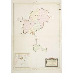
Carta Esferica de Las Islas de Iuizay.. (Ibiza)
Rare chart of Ibiza. Prepared by Antonio Valdés. Engraved by S.Brieva. Detailed chart giving soundings, place names and mountains. With inset plan Plano del Puerto de la...
Date: Madrid 1786
Selling price: ????
Please login to see price!
Sold
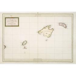
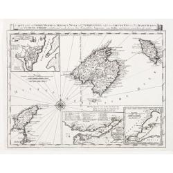
Carta Esferica de Las Yslas Baleares Y Pithyusas..
Rare chart of Majorca, Minorca and Ibiza. Prepared by Antonio Valdés. Engraved by Moreno Taxada. Detailed chart giving some soundings, place names and mountains.
Date: Madrid 1786
Selling price: ????
Please login to see price!
Sold
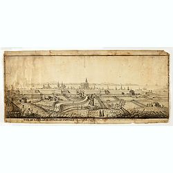
Vue de la Ville de citadelle capitale. Elle est dessinée du costé de terre ou costé de la porte pour aller à mahon.
Interesting and detailed water color of a panoramic view of the town of Mahon, seen from the land side.
Date: Mahon, ca. 1800
Selling price: ????
Please login to see price!
Sold in 2015
![[No title, showing Majorca, minorca and part of the coast of Algaria.]](/uploads/cache/35723-250x250.jpg)
[No title, showing Majorca, minorca and part of the coast of Algaria.]
Very detailed folding map with map of Majorca, Minorca and part of the coast of Algeria. In upper left Spanish coast with Barcelona.
Date: France, c.1830
Selling price: ????
Please login to see price!
Sold in 2015
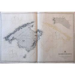
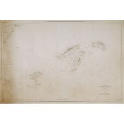
Balearic Islands Majorca & Minorca from Spanish government surveys, 1890-3.
A large sea-chart of Mallorca, Menorca, and Cabrera, published in 1897, with the magnetic variation for 1900. It gives many place names along the coasts, and some informa...
Date: London, 1897
Selling price: ????
Please login to see price!
Sold in 2017

Carta de las islas de Ibiza y Formentera Levantada en los anos 1895 a 1897..
Map showing the islands Ibiza and Formentora, engraved by L. Galvan. 5 Inset profiles of the coast. Numerous place names, soundings and sand banks are shown round the isl...
Date: Madrid, Deposito Hidrografico, 1900
Selling price: ????
Please login to see price!
Sold
Carta de la isla de Mallorca Levantada en los anos de 1889 a 1893..
Map of the island Mallorca showing also part of Minorca and Ibiza. Inset map of the Canal entre Dragonera y Mallorca, inset profile of the coast. Lighthouses contemporary...
Date: Madrid, Deposito Hidrografico, 1900
Selling price: ????
Please login to see price!
Sold
![No title: [Minorca.]](/uploads/cache/16337-250x250.jpg)
No title: [Minorca.]
Geological map showing the island Minorca. Very interestingly in the lower right bottom manuscript notations in pencil with instructions for the editor, with P. Fallot's ...
Date: Paris, c. 1920
Selling price: ????
Please login to see price!
Sold in 2018
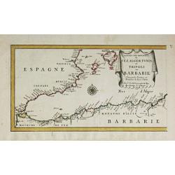
Les Costes des Royaumes de Fez, Alger, Tunis et Tripoli en Barbarie. 1677.
Piere du Val (1618-83), Paris-based cartographer and publisher. Atlases a.o. ' Cartes de Géographie', 1654-88, ' La Géographie universelle' , 1661-1712. After his death...
Date: Paris, 1688.
Selling price: ????
Please login to see price!
Sold in 2014
Carta de las islas Baleares..
Very detailed and rare map, engraved by E. Perez, showing the islands of Majorca, Minorca and Ibiza. Lighthouses and soundings contemporary colored in yellow and red. Ver...
Date: Madrid, Deposito Hidrografico, 1900.
Selling price: ????
Please login to see price!
Sold
![No title: [Minorca]](/uploads/cache/16334-250x250.jpg)
No title: [Minorca]
Geological map showing the island Minorca printed in out-line colors. Very interestingly in the lower left hand bottom a manuscript key to the different geological ages i...
Date: Paris, c. 1920.
Selling price: ????
Please login to see price!
Sold
