Browse Listings in Europe > Mediterranean & Islands
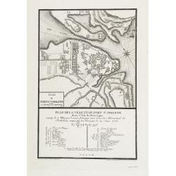
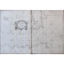
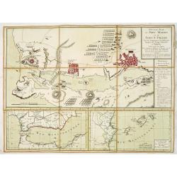
Plan de la Ville et du Port Mahon et du Fort St. Philippe.
Scarce separately issued map of the fort and town St.Philippe and port Mahon in a first state. In upper left corner the title and a key in French (A-Z, Aa-Bb) and a key i...
Date: Paris, ca. 1756
Selling price: ????
Please login to see price!
Sold in 2013
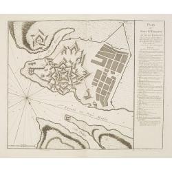
Plan du Fort St. Philippe et de ses Environs : Situés à l'entrée du Port Mahon dans l'Isle de Minorque / Envoyés par Mgr le Marechal Duc de Richelieu. . .
Separately published print of Fort Philippe with numbered key [key: 1-51] to the right. Published on 24 May 1756 by R.J. Julien à l'Hotel de Soubise in Paris. According ...
Date: Paris, ca. 1756
Selling price: ????
Please login to see price!
Sold in 2013
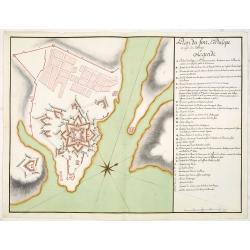
Plan du fort St. Philipe en l'isle de Minorque. . .
Manuscript plan of Fort Philippe with a lettered key [key: A-Z a-h] to the right. This manuscript plan is very similar to the separately published plan by R.J. Julien of...
Date: Paris, ca. 1756
Selling price: ????
Please login to see price!
Sold in 2016
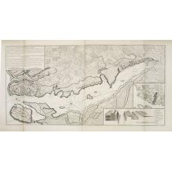
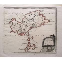
Plan de Lisle de Minorque. / Plan du port Mahon.
Manuscript map of the island of Minorca. The left hand part shows the Bay of Mahon with the town of Mahon and Fort Philippe with a lettered key [A-Z &].The map is fil...
Date: Paris, ca. 1756
Selling price: ????
Please login to see price!
Sold
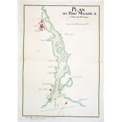
Plan du Port Mahon à l'isle de Minorque.
Uncommon early French manuscript map of the bay and town-planof port Mahón. The entrance of the bay is blocked by "Staccades". St. Philip's Castle still in it ...
Date: Minorca ? / France, ca. 1756
Selling price: ????
Please login to see price!
Sold
D' Reyse des Apostels Pauli na Roomen.
Dutch so-called 'Staten' bibles, published between 1637 and c. 1760, contained 5 maps: The World, 'Paradise', The Perigrinations, The Promised Land Canaan, The Travels of...
Date: Amsterdam / Leiden, R. & J. Wetstein / W. Smith / S. Luchtmans, 1757
Selling price: ????
Please login to see price!
Sold
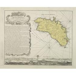
Carte topographique de l'isle Minorque dediée et presentée au roy par le chevalier de Beaurain. . . et communiquée au public par les Heritiers de Homan en l'an 1757.
A rare map depicting the island of Minorca. The upper left is decorated with a stunning title cartouche.The German text on the left side contains a lengthy description of...
Date: Nuremberg, 1757
Selling price: ????
Please login to see price!
Sold in 2010
Plan de la ville et du fort St. Philippe dans l'Isle de Minorque assiégé le 8 mai par l'armée française aux ordres du Maréchal de Richelieu, occupé par les Français le 29 juin 1756.
A military plan of St. Philip's fortifications and fort on the Island of Minorca. With an inset map of Fort St. Philip with a key : 1-26. The model was made by Therbu. En...
Date: Paris, ca. 1762
Selling price: ????
Please login to see price!
Sold in 2009
![[17] La Ciotat.](/uploads/cache/12906-250x250.jpg)
[17] La Ciotat.
Charming chart of the harbor of the town of La Ciotat on Corsica. Showing town and harbor plan, with soundings, anchorages, rocks, shoals, fortifications and lighthouses....
Date: Marseille 1764
Selling price: ????
Please login to see price!
Sold
![[untitled] Balearic: Isle Fromentiere & Ivice](/uploads/cache/90490-250x250.jpg)
[untitled] Balearic: Isle Fromentiere & Ivice
Important chart of the island of Formentera and the southern part of Ibiza. Published in Roux's influental "Recueil des principaux plans des ports et rades de la Med...
Date: Paris 1764
Selling price: ????
Please login to see price!
Sold in 2008
The Coast of the Mediterranean Sea from C. Tenelles to C. Bon, including the Islands of Minorca and Sardinia.
Very rare sea-chart showing the area from Minorca until the coast of Sicily, including most of Sardinia, Pantelleria, and a part of North Africa. With many place names al...
Date: London, 1764
Selling price: ????
Please login to see price!
Sold in 2018
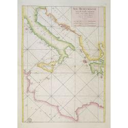
Mer Mediterranée Seconde Feuille contenant L' Italie, Sicile, Golphe de Venise.. Barbarie.
A well engraved and highly detailed chart of the eastern part of the Mediterranean, centered on Italy. Showing soundings, anchorage's, channels, shoals, navigational sigh...
Date: Paris, 1765
Selling price: ????
Please login to see price!
Sold in 2018
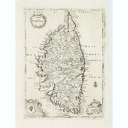
Isola di Corsica.
A very rare map of Corsica, published in " Relazione della Corsica, "which was an Italian translation of the work by Boswell " An Account of Corsica,"...
Date: London, 1769
Selling price: ????
Please login to see price!
Sold
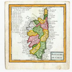
Royaume De Corse.
A map showing Corsica from the uncommon miniature atlas Almanach Geographique ou Petit Atlas Elémentaire, published by Desnos in Paris ca. 1770. Acclaimed French map pub...
Date: Paris ca. 1770
Selling price: ????
Please login to see price!
Sold
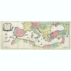
Carte Geographique representant la Mer Mediterranée ou la seconde Partie du Theatre de la Guerre entre les Russes et les Turcs C'est à dire les Roiaumes, les Etâts, les Provinces. . .
A beautiful map of the Mediterranean Sea. Embellished with three compass roses and sailing vessels, including a scene on a naval battle in the Atlantic off of Gibraltar.T...
Date: Augsbourg, 1770
Selling price: ????
Please login to see price!
Sold in 2014
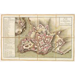
Plan du fort Saint-Philippe dans L'isle de Minorque.
A military plan of Fort St. Philip with a key to the left, with references to the fortifications de San Carlos (Q) et Malborough (R). In upper right corner "N°.3.&q...
Date: Paris, ca. 1770
Selling price: ????
Please login to see price!
Sold in 2013
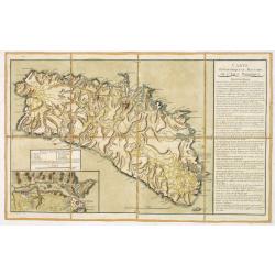
Carte Topographique et Militaire de L'Isle Minorque.
A fine map of Minorca with inset of the Bay of Mahon. With an extensive "Instruction" to the right "ette Carte levée et dessinée par des Officiers de l'A...
Date: Paris, ca. 1770
Selling price: ????
Please login to see price!
Sold in 2013
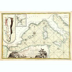
.Carte reduite de la partie occidentale de la mer Mediterranée.
Scarce chart of the Mediterranean published by André Basset. With insets of "Detroit de Gibraltar." and "Plan de Gibraltar". According to the title &...
Date: Paris, 1780
Selling price: ????
Please login to see price!
Sold in 2016
Nouveau Plan du port Mahon et du fort St Philipe Avec les Campements et les différentes Attaques des Troupes Françoises et Espagnoles. . .
A fine map of the Bay of Mahon with a key to the right "Remarques et Renvois du Plan". According to the tittle "Levé sur les Lieux Par les Ingénieurs Mil...
Date: Paris, ca. 1782
Selling price: ????
Please login to see price!
Sold in 2013
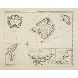
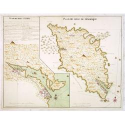
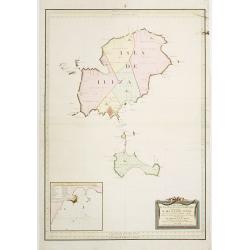
Carte des Isles de Majorque, Minorque, et Yvice..
Decorative map representing the Balearic islands, Minorca, Majorca, Ibiza. With 2 insets and an ornamental title cartouche.Venetian edition of the map by Bellin, to whom ...
Date: Venice, 1776 - 1784
Selling price: ????
Please login to see price!
Sold in 2008
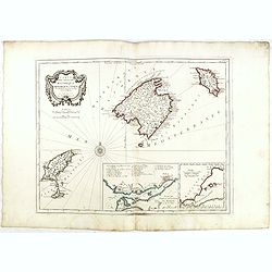
Carte des Isles de Majorque, Minorque, et Yvice. . .
Decorative map representing the Balearic islands. With 2 insets and an ornamental title cartouche.Venetian edition of the map by Bellin, to whom Santini gives credit in t...
Date: Venice, 1776 - 1784
Selling price: ????
Please login to see price!
Sold in 2015
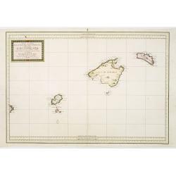
Carta Esferica de Las Yslas Baleares Y Pithyusas..
Rare chart of Majorca, Minorca and Ibiza. Prepared by Antonio Valdés. Engraved by Moreno Taxada. Detailed chart giving some soundings, place names and mountains.
Date: Madrid 1786
Selling price: ????
Please login to see price!
Sold
Carta Esferica de Las Islas de Iuizay.. (Ibiza)
Rare chart of Ibiza. Prepared by Antonio Valdés. Engraved by S.Brieva. Detailed chart giving soundings, place names and mountains. With inset plan Plano del Puerto de la...
Date: Madrid 1786
Selling price: ????
Please login to see price!
Sold
Les Isles de Sardaigne et de Corse..
Attractive copper engraved map of Corsica and Sardinia with Rome at extreme left. Good detail throughout including villages, rivers, and coastlines. Decorated with a nice...
Date: Paris 1790
Selling price: ????
Please login to see price!
Sold
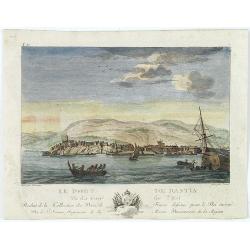
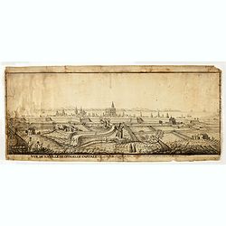
Le port de Bastia vu du coté de l'est. . .
Beautiful engraved profile view of Bastia, after Nicolas Ozanne engraved by Le Gouaz.
Date: Paris, ca. 1790
Selling price: ????
Please login to see price!
Sold in 2023
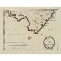
Der Insel Majorca Südlicher Theil. . .
Map showing the southern part of Majorca and just off the south coast of Mallorca, the island of Cabrera. Including cities of Palma, Santueri, Estarella. Published by Fra...
Date: Vienna, 1791
Selling price: ????
Please login to see price!
Sold in 2010
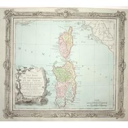
Die Inseln Iviza und Formentera.
Very rare map showing Ibiza and Formentera. With interesting notes in German: Formentera being uninhabited; scattered houses on Ibiza; passage for large ships;...
Date: Vienna, 1791
Selling price: ????
Please login to see price!
Sold in 2015
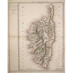
Département de l'Isle de Corse..
Detailed map of Corsica prepared and published by Doudan Dumez in his Atlas de la France.. par une société d'ingénieurs François..
Date: Paris 1794
Selling price: ????
Please login to see price!
Sold
Carte de la Geographie Sacree pour L ' Ancien Testament. 1716.
Pierre Moullart-Sanson, grandson of Nicolas Sanson Sr., succeeded by his nephew Gilles Robert de Vaugondy. Charles François Delamarche (1740-1817), successor to Didier R...
Date: Paris, 1797
Selling price: ????
Please login to see price!
Sold
Vue de la Ville de citadelle capitale. Elle est dessinée du costé de terre ou costé de la porte pour aller à mahon.
Interesting and detailed water color of a panoramic view of the town of Mahon, seen from the land side.
Date: Mahon, ca. 1800
Selling price: ????
Please login to see price!
Sold in 2015
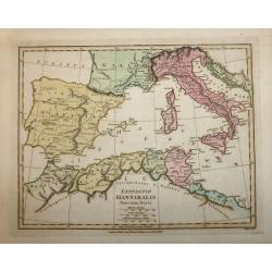
EXPEDITIO HANNIBALIS POENORUM DUCIS
A copper engraved map by John Roper which was published in "Wiklinson's Atlas Classica" in 1803. The map covers the Mediterranean & Islands, Tunisia, Spain,...
Date: London, 1803
Selling price: ????
Please login to see price!
Sold in 2016
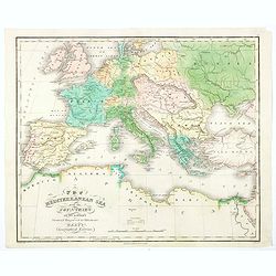
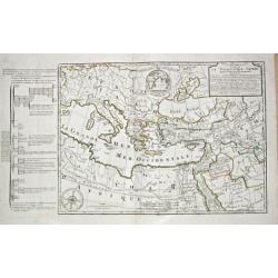
The Mediterranean Sea with the Countries on its Borders.
An interesting and unusual map of the Mediterranean Sea, and her adjoining countries, published in America during the first half of the nineteenth century as part of Hart...
Date: America, ca 1826
Selling price: ????
Please login to see price!
Sold in 2020
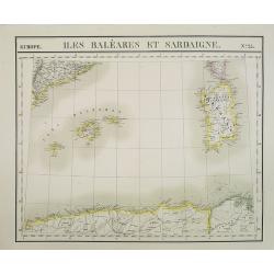
Europe. Isles Baléares et Sardaigne. N.25.
Detailed map including Baleares and Sardinia. Along the lower part the coast line of Algeria.From his famous Atlas Universel . This atlas was one of the most remarkable w...
Date: Brussels, 1825-1827
Selling price: ????
Please login to see price!
Sold in 2013
![[No title, showing Majorca, minorca and part of the coast of Algaria.]](/uploads/cache/35723-250x250.jpg)
[No title, showing Majorca, minorca and part of the coast of Algaria.]
Very detailed folding map with map of Majorca, Minorca and part of the coast of Algeria. In upper left Spanish coast with Barcelona.
Date: France, c.1830
Selling price: ????
Please login to see price!
Sold in 2015
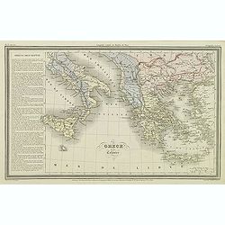
Grèce et ses colonies.
Finely engraved map of Greece, including Macedonia and lower part of Italy, prepared by A.H.Dufour and engraved by Giraldon-Bovinet. Published by Jules Renouard in his un...
Date: Paris, Jules Renouard, ca.1840
Selling price: ????
Please login to see price!
Sold in 2011
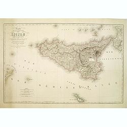
Carte Physique et Routiere de la Sicile..
A very nice exemplary centred on Sicily. Printed by L.Turgis active in Paris and New York. Malta is represented on the bottom.
Date: Paris, 1860
Selling price: ????
Please login to see price!
Sold
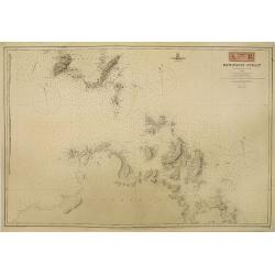
Bonifacio Strait from an Italian Government Survey, 1879. The South Coast of Corsica with the adjacent islands and rocks from a French Government Survey 1884. . .
Detailed chart of the southern Corsican coast with adjacent islands and rocks. Map is taken from an Italian Government Survey dated 1879. Lighthouses marked in yellow and...
Date: London, 1879 & updated 1883
Selling price: ????
Please login to see price!
Sold in 2010
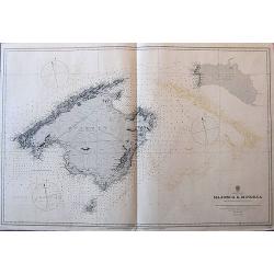
Balearic Islands Majorca & Minorca from Spanish government surveys, 1890-3.
A large sea-chart of Mallorca, Menorca, and Cabrera, published in 1897, with the magnetic variation for 1900. It gives many place names along the coasts, and some informa...
Date: London, 1897
Selling price: ????
Please login to see price!
Sold in 2017
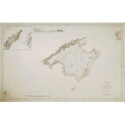
Carta de la isla de Mallorca Levantada en los anos de 1889 a 1893..
Map of the island Mallorca showing also part of Minorca and Ibiza. Inset map of the Canal entre Dragonera y Mallorca, inset profile of the coast. Lighthouses contemporary...
Date: Madrid, Deposito Hidrografico, 1900
Selling price: ????
Please login to see price!
Sold

Carta de las islas de Ibiza y Formentera Levantada en los anos 1895 a 1897..
Map showing the islands Ibiza and Formentora, engraved by L. Galvan. 5 Inset profiles of the coast. Numerous place names, soundings and sand banks are shown round the isl...
Date: Madrid, Deposito Hidrografico, 1900
Selling price: ????
Please login to see price!
Sold
![No title: [Minorca.]](/uploads/cache/16337-250x250.jpg)
No title: [Minorca.]
Geological map showing the island Minorca. Very interestingly in the lower right bottom manuscript notations in pencil with instructions for the editor, with P. Fallot's ...
Date: Paris, c. 1920
Selling price: ????
Please login to see price!
Sold in 2018
![Mer Méditerranée - Partie Ouest. [5321]](/uploads/cache/23547-250x250.jpg)
Mer Méditerranée - Partie Ouest. [5321]
Large chart centered on the western part of the Mediterranean Basin from the Strait of Gibraltar as far as the Dalmatian coast, with soundings indicated in meters.Surroun...
Date: Paris [1914] corrections to 1931
Selling price: ????
Please login to see price!
Sold
![Mer Méditerranée - Partie Est. [5322]](/uploads/cache/23548-250x250.jpg)
Mer Méditerranée - Partie Est. [5322]
Large chart centered on the eastern part of the Mediterranean, with soundings indicated in meters.Surrounded by 28 inset plans of the main European African and Asian town...
Date: Paris [1914] corrections to 1931
Selling price: ????
Please login to see price!
Sold
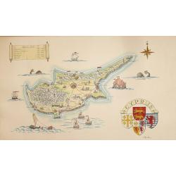
A Pictorial Map of Cyprus.
An attractive hand painted map of Cyprus a scroll cartouche has the Historical dates of the Islands occupation, the map centers on Nicosia. The sea has galleons, sea mons...
Date: ca. 1950
Selling price: ????
Please login to see price!
Sold in 2014
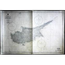
Cyprus
Large Admiralty sea chart of Cyprus.
Date: London, 1964
Selling price: ????
Please login to see price!
Sold in 2017
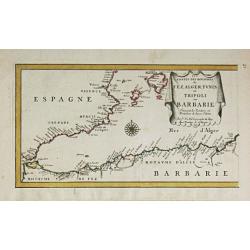
Les Costes des Royaumes de Fez, Alger, Tunis et Tripoli en Barbarie. 1677.
Piere du Val (1618-83), Paris-based cartographer and publisher. Atlases a.o. ' Cartes de Géographie', 1654-88, ' La Géographie universelle' , 1661-1712. After his death...
Date: Paris, 1688.
Selling price: ????
Please login to see price!
Sold in 2014
Carta de las islas Baleares..
Very detailed and rare map, engraved by E. Perez, showing the islands of Majorca, Minorca and Ibiza. Lighthouses and soundings contemporary colored in yellow and red. Ver...
Date: Madrid, Deposito Hidrografico, 1900.
Selling price: ????
Please login to see price!
Sold
![No title: [Minorca]](/uploads/cache/16334-250x250.jpg)
No title: [Minorca]
Geological map showing the island Minorca printed in out-line colors. Very interestingly in the lower left hand bottom a manuscript key to the different geological ages i...
Date: Paris, c. 1920.
Selling price: ????
Please login to see price!
Sold
