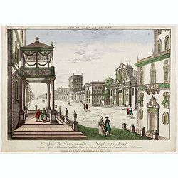
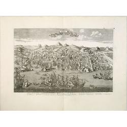
Vue du Place grande a Neaple vers Orient.
So called optical print from "Collection des Prospects" hand-colored at publication. A well-known publisher of optical prints, established in Augsburg. In the e...
Date: Augsburg, 1740
Selling price: ????
Please login to see price!
Sold in 2015
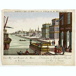
Lust-Hoff und prospect des meeres zu Livorno / L'Hotellerie de plaisance et vuë vers la mer a Livorne.
So called optical print from "Collection des Prospects" hand-colored at publication. A well-known publisher of optical prints, established in Augsburg. Engraved...
Date: Augsburg, 1740
Selling price: ????
Please login to see price!
Sold in 2015

Prospect von Livorno gegen das Meer. Vuë de Livorne du Cote de la Mer.
So called optical print from "Collection des Prospects" hand-colored at publication. A well-known publisher of optical prints, established in Augsburg. Engraved...
Date: Augsburg, 1740
Selling price: ????
Please login to see price!
Sold in 2015

Gross Herzoglicher Lust=Hoff, zu Livorno. Pallais de Plaisance du Grand Duc de Toscane a Livorne.
So called optical print from "Collection des Prospects" hand-colored at publication. A well-known publisher of optical prints, established in Augsburg. Engraved...
Date: Augsburg, 1740
Selling price: ????
Please login to see price!
Sold in 2015
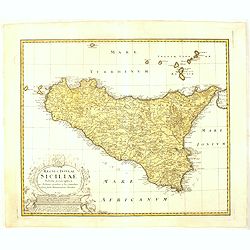
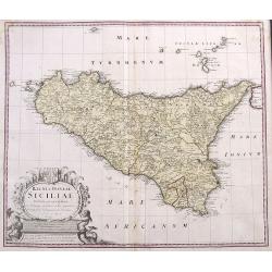
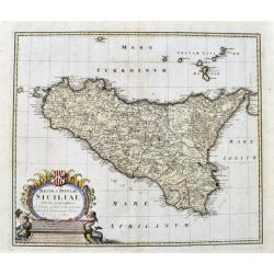
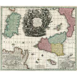
Regni & Insulae Siciliae tabula geographica. . .
Johann Baptist Homann's well-engraved map of Sicily, with a coat of arms and a large decorative title cartouche.Johann Baptist Homann (1663-1724) was a German engraver an...
Date: Nuremberg, ca. 1740
Selling price: ????
Please login to see price!
Sold in 2016

Messina mitt der Neuen Cittadell.
An old birds-eye view of Messina in Sicily. Shows the city from the seaside, with its harbour, fortifications and city walls. Several towers and buildings are shown. With...
Date: Augsburg, ca. 1740
Selling price: ????
Please login to see price!
Sold in 2017

Platea ac Templum D: D: Joannis et Pauli et proxime magnum Sodalitium D. . .
Very fine etching with engraving by Michele Giovanni Marieschi (1696-1743), from the book "Magnificentiores selectioresque urbis Venetiarum prospectus".Michele ...
Date: Venice, 1741
Selling price: ????
Please login to see price!
Sold in 2014
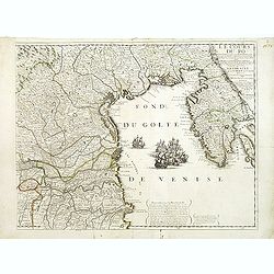
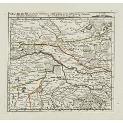
Le Cours du Pô Depuis Turin jusques a ses Embouchures. . . Ce qui fait aujourd'huy Le Théatre de la Guerre en Italie (partie droite seule).
Attractive map of the gulf of Venice, covering the Adriatic coast from the delta of the river Po as far as Istria. It shows many important towns: Ravenna, Ferrara, Vicenz...
Date: Paris, ca. 1742
Selling price: ????
Please login to see price!
Sold in 2019
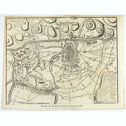
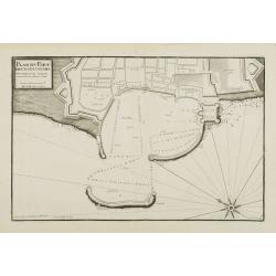
Plan of Turin as besieged in 1706. . .
An interesting copper engraved plan of the Fortification of Turin in Italy, with an attractive rococo bordered key. Nicholas Tindal (1687-1774) / Paul de Rapin (1661-1725...
Date: London, 1743
Selling price: ????
Please login to see price!
Sold in 2021
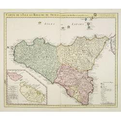
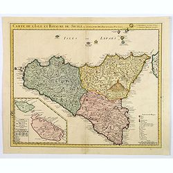
Carte de l'Isle et Royaume de Sicile Par Guillaume del 'Isle . . .
Detailed and rare issue of this map of Sicily prepared by de L'Isle. Beautiful rendering of Mt. Etna. An inset map of the islands of Malta and Gozzo, " Carte particu...
Date: Amsterdam c. 1744
Selling price: ????
Please login to see price!
Sold in 2015
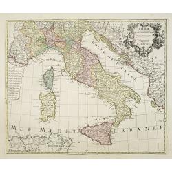
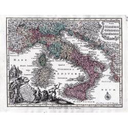
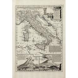
L' Italie, Dressee sur les Observations de Mrs. De L' Academie Royale des Sciences..
A decorative map of Italy, including Sicily, Sardinia, Corsica, part of the Mediterranean Sea, and portions of the neighboring countries of Slovenia, Albania, Montenegro,...
Date: Amsterdam, c. 1744
Selling price: ????
Please login to see price!
Sold in 2009
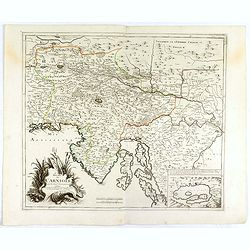
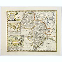
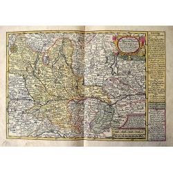
Le Duché de Carniole. . .
Fine map of part of Italy with Istria and part of Slovenia with a splendid cartouche. With inset of "Lake de Gireknitz" in lower right corner. From his rare atl...
Date: Paris, 1744
Selling price: ????
Please login to see price!
Sold in 2016
Carte de l'Isle et Royaume de Sicile Par Guillaume del 'Isle . . .
A detailed and rare issue of this map of Sicily prepared by de L'Isle, highlighted by some beautiful rendering of Mt. Etna. An inset map of the islands of Malta and Gozzo...
Date: Amsterdam ca 1744
Selling price: ????
Please login to see price!
Sold in 2021
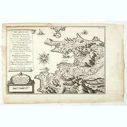
Hic Jacent Puteolorum Bajarum, Miseni Cumarium. . .
A bird's-eye view of Puzzoli and environs, depicting fascinating topographical and architectural features of interest. Title cartouche describes the map and area in Latin...
Date: London, 1725-1744
Selling price: ????
Please login to see price!
Sold
Nova Totius Italiae cum adjacentibus majoribus et minorib insulis tabula …
A detailed map of Italy and the islands of Corsica, Sardinia and Sicily together with its possessions along the Dalmatian coastFrom: Atlas Minor Praecipua Orbis Terrarum ...
Date: Augsburg, circa 1744
Selling price: ????
Please login to see price!
Sold in 2023
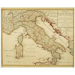
Tabula Italiae Antiquae..
Very decorative map of the Italian peninsula.The map is from a Dutch edition of De L'Isle's work entitled, Atlas Nouveau, Contenant Toutes Les Parties Du Monde, Ou sont e...
Date: Amsterdam c. 1745
Selling price: ????
Please login to see price!
Sold
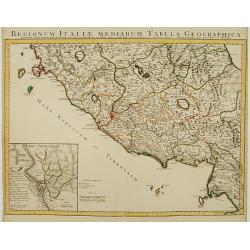
Regionum Italiae Mediarum Tabula Geographica.
Very decorative map of the central Italy showing Rome at the centre of the sheet. An interesting inset on lower left corner of the map illustrates topographical features ...
Date: Amsterdam, c. 1745
Selling price: ????
Please login to see price!
Sold in 2014
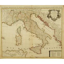
L' Italie, Dressee sur les Observations de Mrs. De L' Academie Royale des Sciences..
A large, highly detailed map of the Italian peninsula and the surrounding parts of France and the Balkans. Includes Sardinia and Corsica. Decorated with a fine title cart...
Date: Amsterdam c. 1745
Selling price: ????
Please login to see price!
Sold
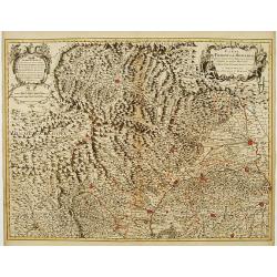
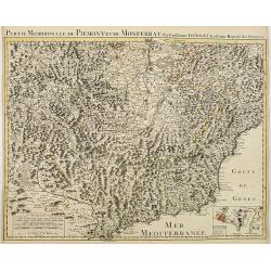
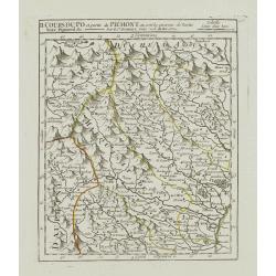
Carte du Piemont et du Monferrat Dressée sur plusieurs Cartes..
Large, detailed map of Valle d'Aosta and most part of Piedmont. Includes illustrated topography with notations about towns, roads, passes, mountains, etc. Relief shown pi...
Date: Amsterdam, c. 1745
Selling price: ????
Please login to see price!
Sold in 2008
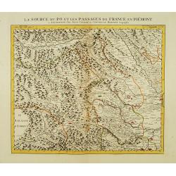
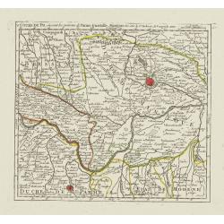
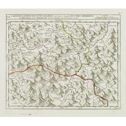
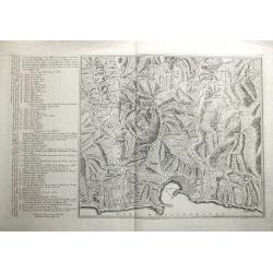
La Source du Po, et les passages de France en Piémont.
First of 5 detailed maps illustrating the flow of the river Po, in northern Italy, this maps depicts the mountainous area at the border between Italy and France. Relief s...
Date: Amsterdam c. 1745
Selling price: ????
Please login to see price!
Sold

Le Cours du Po dans le Piemont et le Montferrat.
Second of 5 detailed maps illustrating the flow of the river Po, in northern Italy, this maps depicts the stretch of river flowing through the Piedmont and the Monferrato...
Date: Amsterdam c. 1745
Selling price: ????
Please login to see price!
Sold
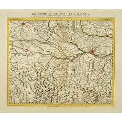
Le Cours du Po dans le Milanez.
Third of 5 detailed maps illustrating the flow of the river Po, in northern Italy, this maps depicts the stretch of river marking the natural border between Lombardy and ...
Date: Amsterdam c. 1745
Selling price: ????
Please login to see price!
Sold
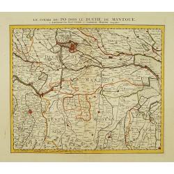
Le Cours du Po dans le Duche de Mantoue.
Fourth of 5 detailed maps illustrating the flow of the river Po, in northern Italy, this maps depicts the stretch of river flowing through the province of Mantua as far a...
Date: Amsterdam c. 1745
Selling price: ????
Please login to see price!
Sold
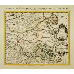
Le Cours du Po dans le Duché de Ferrare et les Etats de Venise..
Last of 5 detailed maps illustrating the flow of the river Po, in northern Italy, this maps depicts the last stretch of river from Ravalle as far as its delta into the Ad...
Date: Amsterdam c. 1745
Selling price: ????
Please login to see price!
Sold
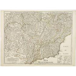
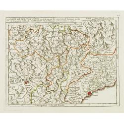
Partie Meridionale du Piemont et du Monferrat..
Map covering the southern part of the Piedmont and the "Riviera di ponente", the sea coast at the east of Genoa. It includes par of France and the Principality ...
Date: Paris 1745
Selling price: ????
Please login to see price!
Sold
Partie Meridionale du Piemont et du Monferrat . . . plusieurs Cartes..
Large, detailed map of Valle d'Aosta and most part of Piedmont. Includes illustrated topography with notations about towns, roads, passes, mountains, etc. Relief shown pi...
Date: Amsterdam, c. 1745
Selling price: ????
Please login to see price!
Sold
Plan de Genes
A rare plan of Genoa by Le Rouge. Showing the fortified city with the adjacent streets, title on top, key on the right. Decorated with a compass rose.
Date: Paris, 1745
Selling price: ????
Please login to see price!
Sold in 2011
![[Untitled] Front views of the Tyrrhenian coastal relief of Italy.](/uploads/cache/24835-250x250.jpg)
[Untitled] Front views of the Tyrrhenian coastal relief of Italy.
Copper engraving presenting separate front views of the coastal relief of Italy between Tuscany and Campania with its Tyrrhenian islands, divided in stripes.From the rare...
Date: Marseille, 1732 - 1746
Selling price: ????
Please login to see price!
Sold in 2009
![[Untitled] Front views of the Italian coastal relief.](/uploads/cache/24836-250x250.jpg)
[Untitled] Front views of the Italian coastal relief.
Copper engraving presenting separate front views of the Tyrrhenian as well as Ionian coastal relief of Italy, divided in stripes.From the rare chart book by Jacques Ayrou...
Date: Marseille, 1732 - 1746
Selling price: ????
Please login to see price!
Sold in 2009
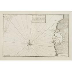
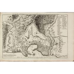
Plan du Port et Rade de Livourne..
Copper engraving showing the harbor and roadstead of Livorno with the adjacent seashores. Decorated with a large compass rose.From the rare chart book by Jacques Ayrouard...
Date: Marseille, 1732 - 1746
Selling price: ????
Please login to see price!
Sold in 2009
Plan du Port et Rade de Livourne..
Copper engraving centered on the harbour and roadstead of Livorno. Decorated with a large compass rose.From the rare chart book by Jacques Ayrouard: Recueil de plusieurs ...
Date: Marseille, 1732 - 1746
Selling price: ????
Please login to see price!
Sold in 2015
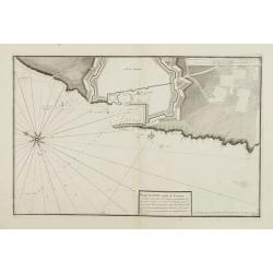
Plan du Port de Civita-Vechia. . .
Large plan of the harbour in Civitavecchia. Decorated with a large compass rose.From the rare chart book by Jacques Ayrouard: Recueil de plusieurs Ports .. de la Mer Méd...
Date: Marseille, 1732 - 1746
Selling price: ????
Please login to see price!
Sold in 2015
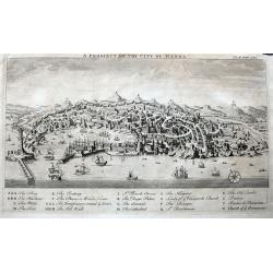
A Prospect of the City of Genoa.
A highly detailed birds-eye view of Genoa. Withy numerous buildings and landmarks of the surrounding area shown. The harbour is filled with sailing ships. A key below nam...
Date: London, ca 1746
Selling price: ????
Please login to see price!
Sold in 2022
A New & Accurate Map of the Kingdoms of Naples & Sicily
Decorative engraved map of South Italy by Bowen from 'A Complete System of Geography'. Showing the southern part of Italy with Sicily. With one decorative cartouche, a co...
Date: London, 1747
Selling price: ????
Please login to see price!
Sold in 2011
A New and Accurate Map of Italy Drawn from the Latest and Best Authorities, and Regulated by the Most Approved Astronl. Observations
Decorative engraved map of Italy by Bowen from 'A Complete System of Geography'. Below with to inset views of Mount Vesuvius eruptions. With one decorative cartouche, a c...
Date: London, 1747
Selling price: ????
Please login to see price!
Sold in 2013
Regni & Insulae Siciliae Tabula geographica ex Archetypo...
A fine and detailed map of Sicily and the Aeolian Islands. Includes many towns, roads, mountains, rivers, bays, etc. Decorated with a large cartouche.
Date: Nuremberg, 1747
Selling price: ????
Please login to see price!
Sold in 2017
A New and Accurate Map of Savoy, Piedmont, and Montferrat. . .
This is the striking 1747 map of Savoy, Piedmont and Montserrat in northern Italy by Emanuel Bowen. It covers part of modern day France and Italy from Lake Geneva south a...
Date: London, 1747
Selling price: ????
Please login to see price!
Sold in 2018
Middle or Proper Italy.
A map of central Italy, from Roman times, and published in "An Universal History from the Earliest Account of Time to the Present". With a quaint title cartouch...
Date: London, ca 1747
Selling price: ????
Please login to see price!
Sold in 2019
A Map of Great Greece and of the Islands of Sardinia and Corsica. . .
A map showing the islands of Sardinia and Corsica, and southern Italy to the northern tip of Sicily in roman times. From "An Universal History, from the Earliest Acc...
Date: London, 1747
Selling price: ????
Please login to see price!
Sold in 2020
Regni & Insulae Siciliae tabula geographica...
A very detailed map of Sicily and surrounding smaller islands (Lipari, Stromboli, Ustica, etc.). Shows the Etna volcano, rivers, hills, roads, and many place names. With ...
Date: Nuremberg, ca. 1747
Selling price: ????
Please login to see price!
Sold in 2021
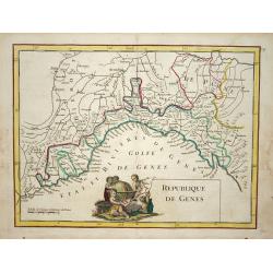
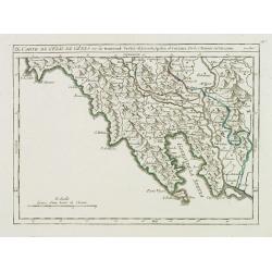
Republique de Genes.
Nice map of northwest Italy and the Gulf of Genoa, at left Nice and Monaco, there is a nice putti-scene in the sea.
Date: Paris 1748
Selling price: ????
Please login to see price!
Sold
II. Cours du Po et Partie du Piémont où sont les environs de Turin..
Detailed small map showing the northwestern part of Piedmont and a short stretch of the river Po going through Turin.Relief shown pictorially. From Atlas Portatif Univers...
Date: Paris, later than 1748
Selling price: ????
Please login to see price!
Sold
V. Cours du Po, où sont les environs de Parme, Guastalle, Mantoue, &c.
Detailed small map centered on the stretch of the river Po flowing through the region Lombardy, between Villanova sull'Arda and San Siro, southeast of Mantua.From Atlas P...
Date: Paris, later than 1748
Selling price: ????
Please login to see price!
Sold
VI. Cours du Po, ou sont les environs de la Mirandole, partie du Veronese, Padouan, Ferrarese, Bolonois, &c.
Detailed small map centered on the stretch of the river Po flowing between Ostiglia and Ro, in the Province of Ferrara.From Atlas Portatif Universel, by Robert de Vaugond...
Date: Paris, later than 1748
Selling price: ????
Please login to see price!
Sold
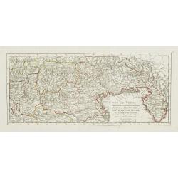
Etat de la Seigneurie et République de Venise avec l'Evêché de Trente.
Detailed small map of northern Italy. Including Istria in the East and extending westwards as far as Bergamo and Crema.From Atlas Portatif Universel, by Robert de Vaugond...
Date: Paris, 1748
Selling price: ????
Please login to see price!
Sold in 2010
![[III]. Carte de l'Etât de Gênes où se trouvent la Principauté d'Oneille, les enviros d'Albinga, le Marquisat de Finale &c.](/uploads/cache/24546-250x250.jpg)
[III]. Carte de l'Etât de Gênes où se trouvent la Principauté d'Oneille, les enviros d'Albinga, le Marquisat de Finale &c.
Detailed small map showing the Ligurian seacoast stretching from Oneglia as far as Vado Ligure.Relief shown pictorially. From Atlas Portatif Universel, by Robert de Vaugo...
Date: Paris, later than 1748
Selling price: ????
Please login to see price!
Sold in 2013
IV. Carte de l'Etât de Gênes ou se trouvent les environs de Savone..
Detailed small map showing an area straddling the Piedmontese province of Cuneo and the Ligurian province of Savona.Relief shown pictorially. From Atlas Portatif Universe...
Date: Paris, later than 1748
Selling price: ????
Please login to see price!
Sold in 2013
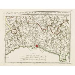
V. Carte des Environs de Genes..
Detailed small map centered on Genoa. With Portofino in the lower right corner. Relief shown pictorially.From Atlas Portatif Universel, by Robert de Vaugondy.Page 56.e ou...
Date: Paris, later than 1748
Selling price: ????
Please login to see price!
Sold in 2017
VII. Carte des Confins de l'Etât de Gênes.. Milanez et du Parmesan.
Detailed small map showing an area straddling the provinces of Alessandria, Pavia and Piacenza on 3 different regions.Relief shown pictorially. From Atlas Portatif Univer...
Date: Paris, later than 1748
Selling price: ????
Please login to see price!
Sold in 2014
IX. Carte de l'Etât de Gênes ou se trouvent Sestri-di Levante, Spetia et Sarzana.
Detailed small map showing the east most tip of Liguria. Relief shown pictorially.From Atlas Portatif Universel, by Robert de Vaugondy.Page 56.i outside border top right....
Date: Paris, later than 1748
Selling price: ????
Please login to see price!
Sold in 2008
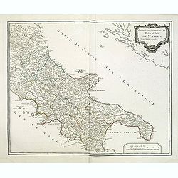
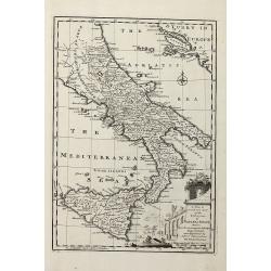
Partie septentrionale du Royaume de Naples.
Map of the southern part of Italy with Naples from his "Atlas Universel".Gilles Robert de Vaugondy (1688–1766), also known as Le Sieur or Monsieur Robert, and...
Date: Paris, 1748
Selling price: ????
Please login to see price!
Sold
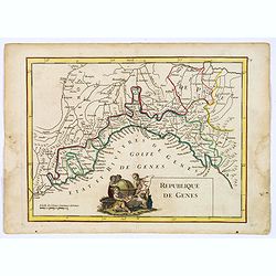
Republique de Genes.
A nice map of northwest Italy and the Gulf of Genoa, at left Nice and Monaco, there is a nice putti-scene in the sea, reflecting Genoese exploration and discovery around ...
Date: Paris, 1748
Selling price: ????
Please login to see price!
Sold in 2019
Das meiste von der Lombardey als Meyland, Parma und Piacenza...
Rare map of Lombardy, Piemont, Aosta, Liguria, and Ticino in Switzerland. With the Lago Maggiore, Lago di Como, Lago di Garda, Lago d'Iseo. Extends from Torino to Verona,...
Date: Leipzig, 1749
Selling price: ????
Please login to see price!
Sold in 2017
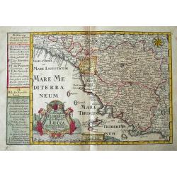
Das Groshertzogthum Florentz und die Republic Lucca...
Fine map of Tuscany. Extends from Genoa until Civitavecchia, and inland until Cervia. With Elba and Isola del Giglio. Filled with place names, such as Florence, Siena, Lu...
Date: Leipzig, 1749
Selling price: ????
Please login to see price!
Sold in 2018

Vue perspective de la Cathedrale de Milan.
An optical view of the Dome of Milan.
Date: Paris, c. 1750
Selling price: ????
Please login to see price!
Sold
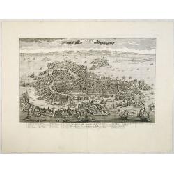
Venise / Ville capitale de la République de même nom en Italie.
A very decorative and extremely rare town plan of Venice, including a numbered legend in the lower part. Published by Jacques Chéreau, (1688 - 1776). Engraved by Pierre-...
Date: Paris, ca.1750
Selling price: ????
Please login to see price!
Sold
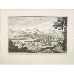
Florence. Florence Ville d'Tialie, capitale de Toscane. . .
A very decorative and extremely rare town-view of Florence, in Tuscany. Including a 4-line text in lower part. Published by Jacques Chéreau, (1688 - 1776). Engraved by A...
Date: Paris, ca.1750
Selling price: ????
Please login to see price!
Sold in 2016
Genes. Ville Capitale de la Republique de meme nom seituée sur la mer méditerranée en Italie.
A very decorative and extremely rare of Genoa, including a numbered key ( 1-30 ) in lower part. Published by Jacques Chéreau, (1688 - 1776). Engraved by Aveline and fir...
Date: Paris, ca.1750
Selling price: ????
Please login to see price!
Sold in 2012
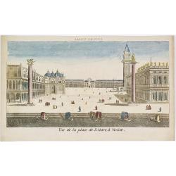
Vue de la Place de S.Marc à Venise.
Showing the St.Marco Square in Venice. Mondhard was a well-known publisher of optical prints, established in rue St.Martin in Paris. In the eighteenth and nineteenth cent...
Date: Paris, ca. 1750
Selling price: ????
Please login to see price!
Sold in 2009
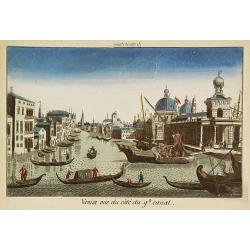
Venise vue du côté du g(rann)d canal.
Showing the Grand Canal in Venice. Likely published by Mondhard, a well-known publisher of optical prints, established in rue St.Martin in Paris. In the eighteenth and ni...
Date: Paris, ca. 1750
Selling price: ????
Please login to see price!
Sold in 2009

Palais du Doge à Venise.
Showing the Doge's Palace in Venice. Likely published by Mondhard, who was a well-known publisher of optical prints, established in rue St.Martin in Paris. In the eightee...
Date: Paris, ca. 1750
Selling price: ????
Please login to see price!
Sold in 2012
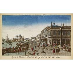
Eglise S.Théodore et entrée du grand canal de Venise.
Showing the entrance of the Grand Canal in Venice. Likely published by Mondhard, who was a well-known publisher of optical prints, established in rue St.Martin in Paris. ...
Date: Paris, ca. 1750
Selling price: ????
Please login to see price!
Sold in 2013

Intérieur de l'Eglise St.Marc à Venise.
Showing the interior of Saint Mark's Basilica in Venice. J. Chereau was a publisher of optical prints, established in Paris, rue St.Jacques.In the eighteenth and nineteen...
Date: Paris, ca. 1750
Selling price: ????
Please login to see price!
Sold in 2013
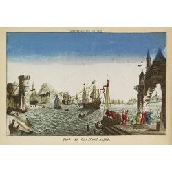
Port de Constantinople.
Showing a fanciful presentation of the harbor of Constantinople (Istanbul). J. Chereau was a publisher of optical prints, established in Paris, rue St.Jacques.In the eigh...
Date: Paris, ca. 1750
Selling price: ????
Please login to see price!
Sold in 2009
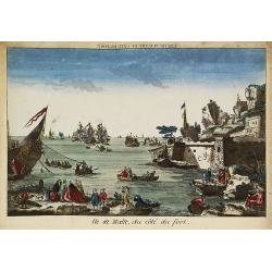
Ile de Malte, du côté du fort.
Showing to the right part of Fort St. Elmo at Valletta, with a lively foreground and a sea battle in the bay. The mirror-image title reads "Vue de Malthe du côté d...
Date: Paris, ca. 1750
Selling price: ????
Please login to see price!
Sold in 2009
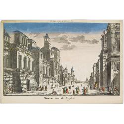
Grande rue de Naples.
Showing a street scene in Naples. J. Chereau was a publisher of optical prints, established in Paris, rue St.Jacques.In the eighteenth and nineteenth centuries there were...
Date: Paris, ca. 1750
Selling price: ????
Please login to see price!
Sold in 2016

Vaisseau en feu dans le port de Messine.
Showing a fanciful depiction of the harbor of Messina on the island of Sicily and a burning vessel. J. Chereau was a publisher of optical prints, established in Paris, ru...
Date: Paris, ca. 1750
Selling price: ????
Please login to see price!
Sold in 2010

Intérieur de la Basilique de Saint Pierre.
Showing the Papal Basilica of Saint Peter, officially known in Italian as the Basilica Papale di San Pietro in Vaticano in Rome. J. Chereau was a publisher of optical pri...
Date: Paris, ca. 1750
Selling price: ????
Please login to see price!
Sold in 2013

Basilique de St.Pierre et Palais du Vatican à Rome.
Showing the Papal Basilica of Saint Peter, and the Papal Palace in Vatican in Rome. J. Chereau was a publisher of optical prints, established in Paris, rue St.Jacques.In ...
Date: Paris, ca. 1750
Selling price: ????
Please login to see price!
Sold in 2013
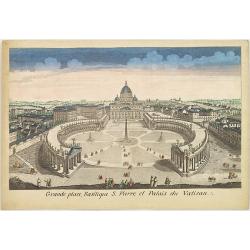
Grande place, Basilique S. Pierre et Palais du Vatican.
Showing the Papal Basilica of Saint Peter, and its square in the Vatican in Rome. J. Chereau was a publisher of optical prints, established in Paris, rue St.Jacques.In th...
Date: Paris, ca. 1750
Selling price: ????
Please login to see price!
Sold in 2013
Siciliae Regnum cum adjacente Insula Sardinia et maxima parte Regni Neapolitani.
Map of Sicily, Sardinia, Malta and parts of Corsica, South Italy and North Africa. Inset map of Messina and Cartana.
Date: Augsburg, 1750
Selling price: ????
Please login to see price!
Sold in 2010
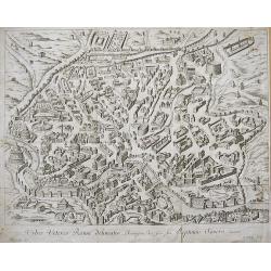
URBIS VETERIS ROMAE DELINEATIO...
Nice engraved bird's-eye plan view of ancient Rome with great detail of the buildings, streets, and monuments... Very decorative engraving by P. Philip. Rare to appear o...
Date: ca. 1750
Selling price: ????
Please login to see price!
Sold in 2010
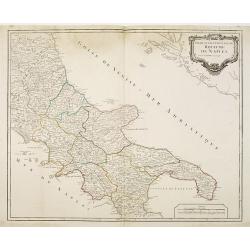
Partie septentrionale du Royaume de Naples.
Map of the southern part of Italy with Naples.
Date: Paris, c.1750
Selling price: ????
Please login to see price!
Sold in 2011
Carte Géometrique de la Ville et des Environs de Gene, ou on voit l'Expedition des Imperiaux et Piemontois contre les Genois et leurs alliez, avec les differents Postes, Retranchements, attaques, déffenses, et Mouvements des deux Parties, le tout desine s
RARE and unidentified map of the area around Genoa (Genova) in Italy. Large map, superbly engraved. With an extensive key to the right, identifying numerous fortification...
Date: ca. 1750
Selling price: ????
Please login to see price!
Sold in 2011
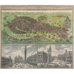
Venetia Potentissima e la più Magnifica...
Striking hand-colored bird's town-plan of Venice with two views of St. Mark's Square (Piazza San Marco), one showing the famous "Gondolas". The detailed plan in...
Date: Augsburg, c.1750
Selling price: ????
Please login to see price!
Sold in 2011
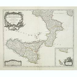
Partie méridionale du royaume de Naples où se trouvent la Calabre et l'isle et royaume de Sicile. . .
Detailed map of Calabria and Sicily, and inset map with Malte Islands. Dated 1750.Ornated with a large title cartouche and a scale cartouche in the left corners. Inset ma...
Date: Paris, 1750
Selling price: ????
Please login to see price!
Sold in 2011
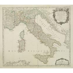
L'Italie qui comprend les états de Piémont. . .
Detailled map of Italy, including the island of Corsica, Sardaigna and Sicily from his "Atlas Universel".Gilles Robert de Vaugondy (1688–1766), also known as ...
Date: Paris, 1750
Selling price: ????
Please login to see price!
Sold in 2018
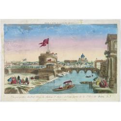
Vue perspective du pont Elian, du château St Ange, et d'une partie de la ville de Rome.
A view of the Castle of St.Angelo and Elian Bridge, with part of the city of Rome. Published by Jacques Chereau, who was a well-known publisher of optical prints, establi...
Date: Paris, ca. 1750
Selling price: ????
Please login to see price!
Sold in 2016
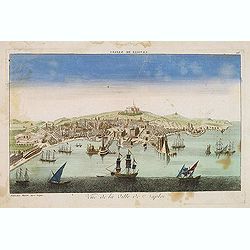
Vue de la ville de Naples. . .
A decorative view of Naples with a busy harbour, published by Basset, who was a well-known publisher of optical prints, established in rue St. Jacques in Paris. In the ei...
Date: Paris, ca. 1750
Selling price: ????
Please login to see price!
Sold in 2014
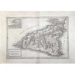
SICILIA ANTIQUA.
Attractive map of Sicily. Detailed with Rivers Mountains including Mt Etna erupting plus an inset map of Malta. From ‘Geographia Antiqua being a Complete Set of Maps of...
Date: London 1750
Selling price: ????
Please login to see price!
Sold in 2017
