Browse Listings in Europe > France > France Provinces
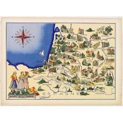
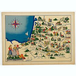
Basque - Bearn - Bigorre.
Very decorative, informative map of Basque - Bearn - Bigorre in south western France. Including the towns of Biarritz, Dax, Bayonne, Lourdes, etc. The map is filled with ...
Date: France, 1943
Selling price: ????
Please login to see price!
Sold in 2013
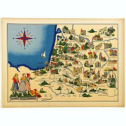
Basque - Bearn - Bigorre.
Very decorative, informative map of Basque - Bearn - Bigorre in south western France. Including the towns of Biarritz, Dax, Bayonne, Lourdes, etc. The map is filled with ...
Date: France, 1943
Selling price: ????
Please login to see price!
Sold in 2014
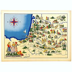
Basque - Bearn - Bigorre.
Very decorative, informative map of Basque - Bearn - Bigorre in south western France. Including the towns of Biarritz, Dax, Bayonne, Lourdes, etc. The map is filled with ...
Date: France, 1943
Selling price: ????
Please login to see price!
Sold in 2016
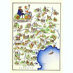
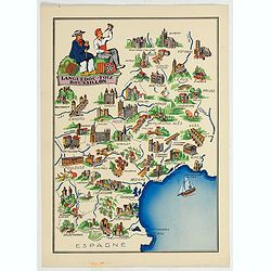
Languedoc - Foix Roussillon.
Very decorative, informative map of Languedoc - Foix Roussillon region in south eastern France. Including the towns of Carcassonne, Montpellier,, Albi, Toulouse, etc.The ...
Date: France, 1943
Selling price: ????
Please login to see price!
Sold in 2016
Languedoc - Foix Roussillon.
This is a very decorative, informative map of the Languedoc - Foix Roussillon region in southeastern France, including the towns of Carcassonne, Montpellier,, Albi, Toulo...
Date: France, 1943
Selling price: ????
Please login to see price!
Sold in 2023
Languedoc - Foix Roussillon.
Very decorative, informative map of Languedoc - Foix Roussillon region in south eastern France. Including the towns of Carcassonne, Montpellier,, Albi, Toulouse, etc.The ...
Date: France, 1943
Selling price: ????
Please login to see price!
Sold in 2022
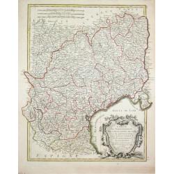
Carte du Bearn de la Bigorre de l'Armagnac..
Map of south-west part of France covering the Landes country with Dax, Bayonne and Pau till Montauban and Toulouse on the right.
Date: Paris [c. 1780]
Selling price: ????
Please login to see price!
Sold
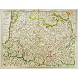
Carte des Gouvernements de Languedoc, de Foix et de Rousillon avec la Partie Oreintale du Gouvernement de Guienne.
Jean Lattré, Paris-based engraver and publisher. Worked with Robert de Vaugondy, J. Janvier and R. Bonne. " Atlas Monderne', 1771, 1783 , 1793. Rigobert Bonne (1727...
Date: Paris, 1783.
Selling price: ????
Please login to see price!
Sold
