Browse Listings in Europe
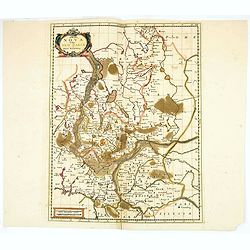
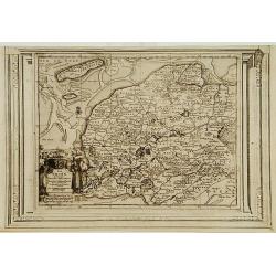
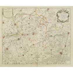
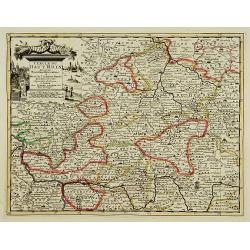
Marchia Nova Vulgo New Marck in March Brandenburg.
Hand-colored copper engraving by Moses Pitt and Stephan Swart. Published in Amsterdam, 1695.
Place & Date: Amsterdam, 1695.
Selling price: $20
Sold in 2020
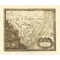
Castra Suedica ad Fridirici Uddam.
From Pufendorf's famous chronicle on the Baltic area, ' Histoire du règne de Charles Gustave, roy de Suède'The Swedish fortifications in front of Fredericia, 1657.
Place & Date: Nürnberg, C. Riegel, 1697.
Selling price: $75
Sold in 2008
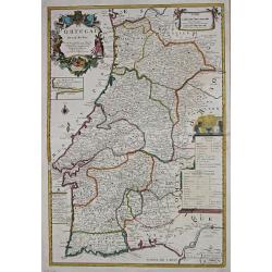
Le Portugal.
Le Père Placide de Sainte-Hélène was the brother-in-law of Pierre Duval. After the death of Duval his widow continued the firm.A large map of Portugal, with an inset o...
Place & Date: Paris, c. 1700.
Selling price: $275
Sold in 2013
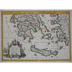
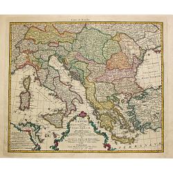
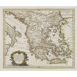
Graecia Antiquae Tabula Nova / Pars Meridionalis.
Guillaume de l' Isle (1675-1724), Royal Geographer, was the most influential cartographer of the first quarter of the 18th century. ' Atlas de Géographie' (1700-12), pos...
Place & Date: Paris, 1707.
Selling price: $360
Sold
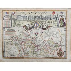
BARKSHIRE DESCRIBED.
Original copperplate engraved map printed on handmade paper, with original hand coloring. A spectacular pictorial of WINDSOR CASTLE across the top of this decorative map....
Place & Date: London, 1710
Selling price: $400
Sold in 2013
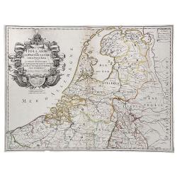
La Hollande ou les Provinces Unies des Pays Bas.
A copperplate border colored map of Holland. A scarce map of the 7 Provinces as published in Paris by Danet. Includes 7 coats of arms in the title cartouche.
Place & Date: Paris, ca. 1720
Selling price: $400
Sold in 2019
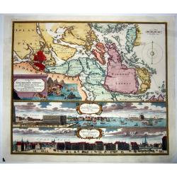
Accurate Carte der Uplandischen Scheren mit der Situation und Gegend umb die Konigle Schwedisch Haupt und Residentz Stadt Stockholm.
A decorative map and a pair of views, focusing on Stockholm and its environs. The map shows Stockholm and the area around it, focusing on the approach from the sea. The ...
Place & Date: Nuremberg , ca 720
Selling price: $335
Sold in 2021
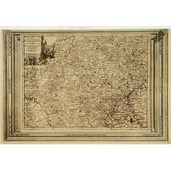
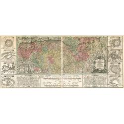
Cercle de Westphalie, suivant les nouvelles observations..
With decorative title cartouche upper left corner.This example is unusual in having the additional separately engraved decorative framework border around the map, the res...
Place & Date: Amsterdam 1728.
Selling price: $70
Sold
La Frise, suivant les nouvelles observations..
With decorative title cartouche lower left corner.This example is unusual in having the additional separately engraved decorative framework border around the map, the res...
Place & Date: Amsterdam 1728.
Selling price: $220
Sold
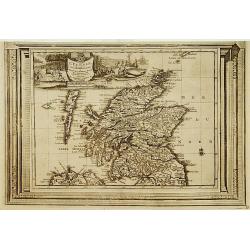
L'Ecosse, suivant les nouvelles observations..
With decorative title cartouche upper left corner.This example is unusual in having the additional separately engraved decorative framework border around the map, the res...
Place & Date: Amsterdam 1728.
Selling price: $270
Sold
Le Duché de Luxembourg, suivant les nouvelles observations..
With decorative title cartouche upper left corner.This example is unusual in having the additional separately engraved decorative framework border around the map, the res...
Place & Date: Amsterdam 1728.
Selling price: $240
Sold in 2009
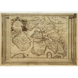
La Zelande, suivant les nouvelles observations..
With decorative title cartouche upper left corner.This example is unusual in having the additional separately engraved decorative framework border around the map, the res...
Place & Date: Amsterdam 1728.
Selling price: $250
Sold
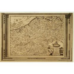
Carte du Comté de Flandre, suivant les nouvelles observations..
Including Belgium and Brabant. With decorative title cartouche lower right corner.This example is unusual in having the additional separately engraved decorative framewor...
Place & Date: Amsterdam 1728
Selling price: $120
Sold
La Gueldre, suivant les nouvelles observations..
With decorative title cartouche lower left corner.This example is unusual in having the additional separately engraved decorative framework border around the map, the res...
Place & Date: Amsterdam 1728.
Selling price: $102
Sold
Cercle de Bavière, suivant les nouvelles observations..
With decorative title cartouche upper right corner.This example is unusual in having the additional separately engraved decorative framework border around the map, the re...
Place & Date: Amsterdam 1728.
Selling price: $90
Sold
Nieuwe Kaart van Europisch Turkyen.
Izaak Tirion (d.1769) Amsterdam publisher. His Nieuwe en beknopte handatlas saw 6 editions between before 1740 and after 1784. Also Tegenwoordige staat van alle volkeren,...
Place & Date: Amsterdam, 1733.
Selling price: $225
Sold
Les Comtez de Hainaut, de Cambresis, et Partie du Comté de Namur..
Uncommon map showing southern Belgium provinces south of Brussels and published by Crepy.Including the towns of Lille, Brussels, Namen, Dinant, Cambray, Mons, etc.
Place & Date: Paris, 1735
Selling price: $300
Sold in 2015
![[RUSSIAN MAP] Battle of Stavuchany 1739.](/uploads/cache/85306-250x250.jpg)
[RUSSIAN MAP] Battle of Stavuchany 1739.
An extremely rare, large Russian single sheet map, of the plan of the battle of Stavuchany. Printed in Russian and German languages, possibly by the Academy of St.Petersb...
Place & Date: St.Petersburg, ca 1739
Selling price: $1500
Sold in 2021
Charte Geographique de la Campagne du Haut Rhin...
Large map by J.F. Oettinger on 2 sheets.
Place & Date: Augsburg, 1740.
Selling price: $300
Sold in 2009
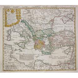
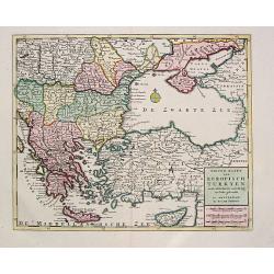
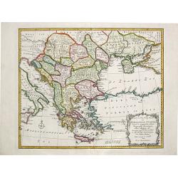
Imperii Turcici Europaei Tera in primis Graeciae.
Homann Heirs (of Johann Baptist and Johann Christof) published: Grosser Atlas, 1731, 1737. Geogr. Maior, 1759, Atlas Homannianus, 1762. A map showing the eastern Mediterr...
Place & Date: Nurnberg, 1741.
Selling price: $345
Sold
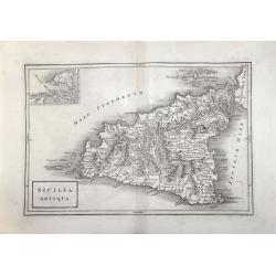
SICILIA ANTIQUA.
Attractive map of Sicily. Detailed with Rivers Mountains including Mt Etna erupting plus an inset map of Malta. From ‘Geographia Antiqua being a Complete Set of Maps of...
Place & Date: London 1750
Selling price: $50
Sold in 2017
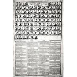
Neu verfertigte Conterfay sampt der Lebens-Beschreibung aller Könige in Spanien wie dieselbe einander ordentlich.. bis auf den jetzt Regierenden. (Karl III.)
Rare engraving depicting, in the upper part, all the kings of Spain till Carl III, in total it depicts 94 Kings.The lower part of the engravings describes each of them.Ra...
Place & Date: Germany, around 1750
Selling price: $150
Sold in 2018
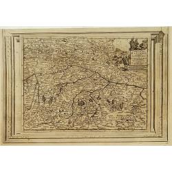
Cercle de Souabe. . .
Finely and crisply engraved map of south part of Germany. Ornamental title cartouche in the upper part of map from his "Atlas Universel".Gilles Robert de Vaugon...
Place & Date: Paris, 1751.
Selling price: $20
Sold in 2015
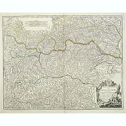
Partie Septentrionale du Cercle d'Autriche..
Detailed map of Austria, with an ornamental cartouche. Relief shown pictorially.
Place & Date: Paris 1752.
Selling price: $52
Sold
Partie Septentrionale du Cercle d'Autriche...
Map showing the postal routes in The Netherlands, Belgium, France, Poland, Austria, Switzerland and Northern Italy. With an ornamental cartouche.
Place & Date: Paris, 1752.
Selling price: $104
Sold
Partie Septentrionale du Cercle d'Autriche. . .
Detailed map of Austria, with an ornamental cartouche. Relief shown pictorially from his "Atlas Universel".Gilles Robert de Vaugondy (1688–1766), also known a...
Place & Date: Paris 1752.
Selling price: $60
Sold
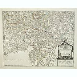
Partie Méridionale du Cercle d'Autriche. . .
Detailed map of Austria, with an ornamental cartouche. Relief shown pictorially from his "Atlas Universel".Gilles Robert de Vaugondy (1688–1766), also known a...
Place & Date: Paris 1752.
Selling price: $60
Sold in 2019
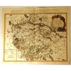
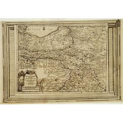
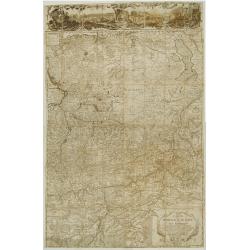
Carte Particuliere de la Principaute de Halberstadt
Carte Particuliere de la Principaute de Halberstadt. A large and rare map of Halberstadt, Germany, and its surroundings by Le Rouge. Showing the town in the German state...
Place & Date: Paris, 17576
Selling price: $112
Sold in 2015
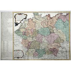
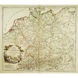
La ALEMANIA dividida en sus principales Estados segun las ultimas y nuevas observationes de las Accademias y de Paris y de Londres.
A beautiful, rare colored map of Germany by the Spanish cartographer Pedro Gendron. As in most 18th century maps published in Spain, which are based upon non-Spanish sour...
Place & Date: Madrid(?), ca 1760
Selling price: $150
Sold in 2020
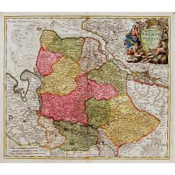
Totius Danubii cum Adjacentibus Regnis nec non totius Graciae et Archipelagi.
Homann Heirs (of Johann Baptist and Johann Christof) published: Grosser Atlas, 1731, 1737. Geogr. Maior, 1759, Atlas Homannianus, 1762.A map depicting southeast Europe wi...
Place & Date: Nurnberg, 1766.
Selling price: $410
Sold
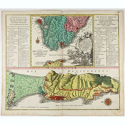
Castellum Gibraltar in Andalusia..
Two maps of Gibraltar on one sheet: a plan of the Rock up to the Spanish lines: and a chart of the Straits, also showing Cadiz and Marbella. The title cartouche shows the...
Place & Date: Augsburg, c.1770.
Selling price: $250
Sold in 2021
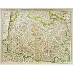
Carte du Bearn de la Bigorre de l'Armagnac..
Map of south-west part of France covering the Landes country with Dax, Bayonne and Pau till Montauban and Toulouse on the right.
Place & Date: Paris [c. 1780]
Selling price: $120
Sold
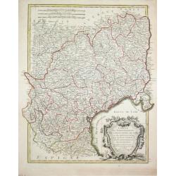
Carte des Gouvernements de Languedoc, de Foix et de Rousillon avec la Partie Oreintale du Gouvernement de Guienne.
Jean Lattré, Paris-based engraver and publisher. Worked with Robert de Vaugondy, J. Janvier and R. Bonne. " Atlas Monderne', 1771, 1783 , 1793. Rigobert Bonne (1727...
Place & Date: Paris, 1783.
Selling price: $120
Sold
Nieuwe en Naauwkeurige Kaart / van / EUROPEËSCH TURKYE / benevens de aangrenzende Landen / Hongaryen, Zevenbergen, / Klein Tartarye enz.
Willem Albert Bachiene (1712-1783), Dutch geographer in Maastricht. Most important work ' Heilige Geographie', a work on the Holy Land. Mathijs Schalenkamp published in 1...
Place & Date: Amsterdam, 1785.
Selling price: $220
Sold
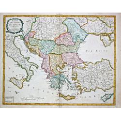
Carte de l' Empire de Turquie en Europe.
Pierre Bourgoin, Paris-based engraver and publisher. Published in 1784 his uncommon ' Atlas Élémentaire de la Géographie'. After his death his widow continued the busi...
Place & Date: Paris, 1788.
Selling price: $160
Sold
The North Prospect of the City of Edinburgh.
A very fine and quite large view of Edinburgh from Joannes Kip's Britannia Illustrata or Views of Several of the Queens Palaces also of the Principal Seats of the Nobilit...
Place & Date: London 1708-20
Selling price: $1300
Sold
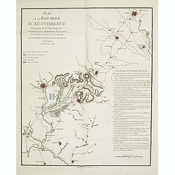
Plan de la bataille d'Austerlitz gagnée par la gde armée française commandée par l'empereur Napoléon sur l'armée austro-russe commandée par les empereurs de Russie et d'Allemagne en personnes le 11 frimaire XIV.
Map of the Battle of Austerlitz of 1805. With a color-key to the French, Russian and Austrian armies. Explicative key for the battle in lower right: A-Q and a -d. prepare...
Place & Date: Paris, 18056
Selling price: $100
Sold in 2013
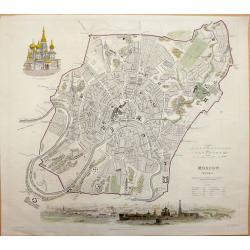
Moscow MOCKBƃI W. B. Clarke for S.D.U.K.- General Atlas...of The Society for the Diffusion of Useful Knowledge.
Very attractive engraved plan of the city centered on the Kremlin. All major streets, many public places, and buildings named. Details shown on many of the fortified area...
Place & Date: London, 1836
Selling price: $200
Sold in 2013
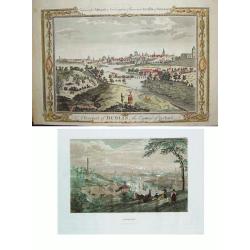
LOT of 2: 1) A Prospect of Dublin the Capital of Ireland 2) Dublin
Two wonderful views of Dublin offered as one lot. Item 1) shows the Liffey River winding through the city. The foreground is filled with citizens, some wealthy and othe...
Place & Date: Item 1) London, ca. 1780. Item 2) Philadelphia, dated 1838.
Selling price: $275
Sold in 2010
Ducato di Lucca.
Very finely engraved and detailed map of the Duche of Lucca during the Roman and Middle Age period. Lower left part of the map, two inset lists of the localities names us...
Place & Date: Rome 1860.
Selling price: $240
Sold

A set of 12 prints of the country seats of the Noblemen & Gentlemen of Ireland
A set of 12 original 1870 color prints from The Rev. F.O. Morris work “A Series of Picturesque Views of Seats of the Noblemen & Gentlemen of Great Britain and Irela...
Place & Date: London & Dublin, 1870
Selling price: $70
Sold in 2017
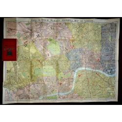
Gall & Inglis Reduced Ordnance Map of London
A large scale folding map of London, published in London by Gall & Inglis in the form of a pocket book. The map is backed, both sides, and the main map is in full ori...
Place & Date: London, 1890
Selling price: $240
Sold in 2016

A set of 20 humorous prints from the Russian Empire's war with the French and British Empire's and beyond
This set of 20 are dated between 1855-1894. Mostly engraved by Joseph Swain. Joseph Swain was one of the most important woodblock engravers. Punch was responsible for the...
Place & Date: London, 1855 - 1894
Selling price: $125
Sold in 2016
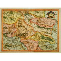
Stiria.
Detailed map of Styria, the most eastern part of Austria, centred on Graz.Signed lower right hand corner Per Gerardum Mercatorem Cum Privilegio.
Place & Date: Amsterdam 1639-44
Selling price: $30
Sold
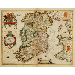
Hibernia regnum vulgo Ireland.
Fine map of Ireland with large coat of arms.
Place & Date: Amsterdam 1639-44
Selling price: $300
Sold
![Scotiae pars Septentrionalis. [2 Maps]](/uploads/cache/16215-250x250.jpg)
Scotiae pars Septentrionalis. [2 Maps]
Detailed map in two sheets depicting the Northern part of Scotland.
Place & Date: Amsterdam 1639-44
Selling price: $300
Sold
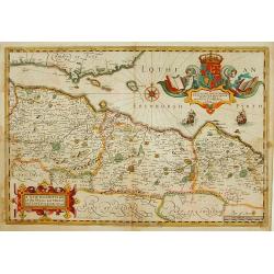
A New Description of the Shyres Lothian and Linlitquo. Be T.Pont.
A Scottish clergyman, Timothy Pont's survey of Scotland of 1595-1608 made that country the best mapped in the world. However it was not until Blaeu issued the maps as Vol...
Place & Date: Amsterdam 1639-44
Selling price: $280
Sold
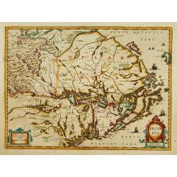
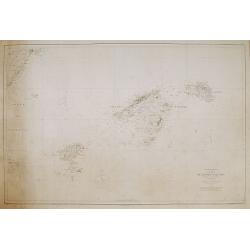
Uplandia.
Covers the area of the modern Uppsala, the vicinity of Stockholm, and includes most of Aland.
Place & Date: Amsterdam 1639-44
Selling price: $360
Sold
Carta de las islas Baleares..
Very detailed and rare map, engraved by E. Perez, showing the islands of Majorca, Minorca and Ibiza. Lighthouses and soundings contemporary colored in yellow and red. Ver...
Place & Date: Madrid, Deposito Hidrografico, 1900.
Selling price: $300
Sold
![No title: [Minorca]](/uploads/cache/16334-250x250.jpg)
No title: [Minorca]
Geological map showing the island Minorca printed in out-line colors. Very interestingly in the lower left hand bottom a manuscript key to the different geological ages i...
Place & Date: Paris, c. 1920.
Selling price: $300
Sold

4 London Transport related maps.
‘Railways Diagram of Lines’ dated January 1951 (The London Underground) 225 x 150 mm.‘Bus Map Country Area’ June 1952, 570 x 430 mm.‘Bus Map Central Area Includ...
Place & Date: London, 1951 -1952
Selling price: $90
Sold in 2016
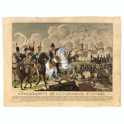
Bombardement de la Citadelle d'Anvers.
Engraving showing the attack of the citadel of Antwerp in November 1832.
Place & Date: Paris
Selling price: $20
Sold in 2016
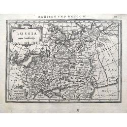
Russia cum Confiniis.
An early map of western Russia from the "Atlas Minor" (Gerhard Mercator / Jodocus Hondius). Extends from Lappland until the Caspian Sea. With two small cartouch...
Place & Date: Amsterdam, 1609 or later
Selling price: $85
Sold in 2018
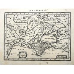
Taurica Chersonesus.
A copper engraved map of the central Ukraine from the "Atlas Minor" (Gerhard Mercator / Jodocus Hondius). Extends from Cherkassy to Crimea and the Sea of Azov. ...
Place & Date: Amsterdam, ca. 1609 -1660
Selling price: $47
Sold in 2018
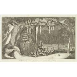
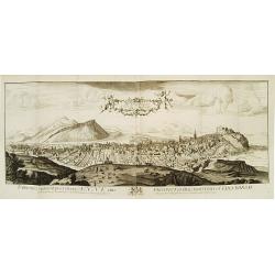
Marmere grot op het eiland Antiparos.
Marble Cave of Antiparos, who is an island in the island group Cyclades in the Aegean Sea, in the modern eparchy of Naxos. The cave itself, which is about 150 feet by 100...
Place & Date: Amsterdam, c.17
Selling price: $10
Sold in 2014
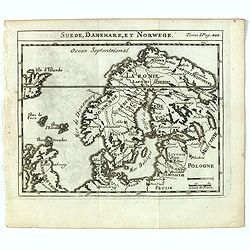
Suede, Danemark, et Norwege.
Scarce small map of Scandinavia based on cartography of Guillaume Delisle (. Published in "Nouveau traité de geographie par M**** ", published by La veuve Lott...
Place & Date: Paris, La veuve Lottin & Butard, P.G. Le Mercier, Rollin, David, Delag
Selling price: $50
Sold in 2016
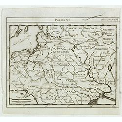
Pologne.
Scarce small map of Poland based on cartography of Guillaume Delisle. Published in "Nouveau traité de geographie par M**** ", published by La veuve Lottin &...
Place & Date: Paris, La veuve Lottin & Butard, P.G. Le Mercier, Rollin, David, Delag
Selling price: $100
Sold in 2015
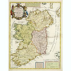
Le Royaume d'Irlande..
Uncommon map of Ireland. A visually stunning map with a large title cartouche. This large one-sheet map was produced by the Venetian cosmographer Vincenzo Coronelli when ...
Place & Date: Paris 1690 / CORONELLI,P.
Selling price: $650
Sold
Lot of 3 maps of Germany.
Robert de Vaugondy: Empire d'Allemagne, 24 cm x 28 cm. Van der AA : Cercle du Haut Rhin, 22,5cm x 29 cm: L'Allemagne, 22,5 cm x 29 cm.The three maps are well-engraved.
Place & Date: Paris/ Leiden
Selling price: $40
Sold
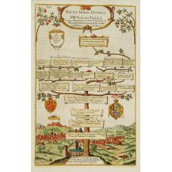
Reges Arpag Veteres..
A family tree of the rulers of Aragon starting with Ennicus (832-861). In lower part a view of Burgos.
Place & Date: England
Selling price: $95
Sold
![[Bottom of Very Large Map] The Duchy of Brabant.](/uploads/cache/98717-250x250.jpg)
[Bottom of Very Large Map] The Duchy of Brabant.
This the bottom of a very large English map showing the following regions: Duchy of Brabant, Luxemburg, Duchy of Limburg, Bishoprick, French Flanders, County of Artois, C...
Place & Date: Unknown
Selling price: $32
Sold in 2017
Carte de la principauté de Liege et de ses environs..
Map of present-day Dutch and Belgium Brabant and Liege, with an imposing title cartouche Carte de la pricipauté de Liége et de ses environs tirée des observations fait...
Place & Date: Liege, ca.1748
Selling price: $450
Sold
Ducatus Bremae et Ferdae nova tabula.
A very decorative and detailed map with Hamburg on the river Elbe. Also including Oldenburg and Bremen. With a very decorative title cartouche showing putti and allegoric...
Place & Date: Nuremberg, 18th century
Selling price: $150
Sold
GREECE.
Map of Greece. Macedonia, western coast of Turkey and part of Italy. Cartouche in the left hand bottom with titles. From the book "History of the Jews" by Humph...
Place & Date: The netherlands 18th. century.
Selling price: $360
Sold in 2008