Browse Listings in Europe
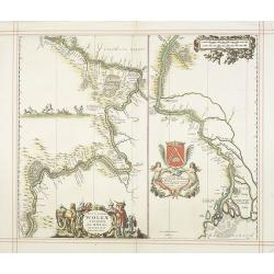
Nova et accurata Wolgae Fluminis olim Rha dicti delineatio Auctore Adamo Oleario.
Showing the Volga River in two parts based on the travels of Adam Olearius. The left side of the map begins at Nazhniy Novgorod and ends at Saratov. The right side contin...
Date: Oxford, 1680
Selling price: ????
Please login to see price!
Sold in 2009
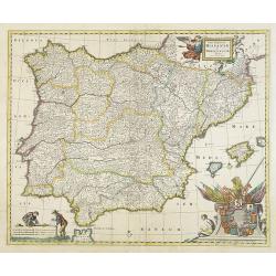
Totius Regnorum HISPANIAE et PORTUGALLIAE descriptio.
A very detailed map. At bottom right a beautiful cartouche with the coats of arms of Portugal and the Spanish provinces.
Date: Amsterdam, 1680
Selling price: ????
Please login to see price!
Sold
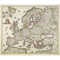
Nova et Accurata totius Europae descriptio. . .
General map of Europe richly ornamented with small compass rose and Europe shown riding Zeus in the form of a bull, and several putti holding the title banner aloft.
Date: Amsterdam, 1680
Selling price: ????
Please login to see price!
Sold in 2009
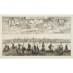
Amsterdam.
Beautiful panoramic town-view Amsterdam seen from the IJ. Extensive shipping in the foreground. Coats-of-arms of the town in top. A label has been pasted underneath the c...
Date: Paris, ca. 1680
Selling price: ????
Please login to see price!
Sold in 2009
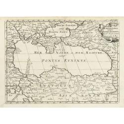
De Zwartezee, eertyts Pontus Euxinus . . .
Map encompassing part of the Near East and the area comprehended between the Black Sea and the Caspian Sea.Prepared by N.Sanson.
Date: Amsterdam, Utrecht, 1680
Selling price: ????
Please login to see price!
Sold in 2010
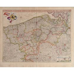
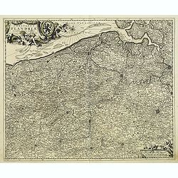
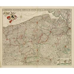
Comitatus Flandria Tabula, in Lucem Edita a Frederico de Wit Amsterdami.
Frederick de Wit map of Flanders region showing from Arras, France on the south to Antwerp, Belgium in the north with beautiful gold leaf detail.
Date: Amsterdam, 1680
Selling price: ????
Please login to see price!
Sold in 2010
Leodiensis Episcopatus.
Visscher map of Belgium and Trier region of Germany with beautiful original color. Shows Antwerp in the upper left corner, Trier, Germany in lower right corner.
Date: Amsterdam, 1680
Selling price: ????
Please login to see price!
Sold in 2010
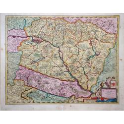
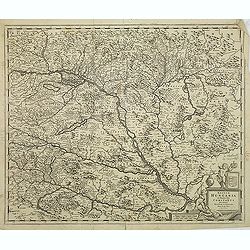
Regnum Hungaria in Omnes fuos Comitatus.
Frederick de Wit map showing Hungary and surrounding regions of Austria and Serbia. The city of Budapest is shown at the center of the map.
Date: Amsterdam, 1680
Selling price: ????
Please login to see price!
Sold in 2010
Comitatus Hannonia Tabula.
Nicolas Vissher map showing region of northern France and Belgium.
Date: Amsterdam, 1680
Selling price: ????
Please login to see price!
Sold in 2010
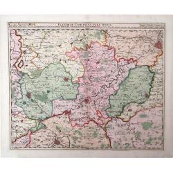
Flandria Comitatus Pars Media.
Nicolas Visscher map, with beautiful original color, showing region of Belgium with city of Gent in the top right corner.
Date: Amsterdam, 1680
Selling price: ????
Please login to see price!
Sold in 2010
Groningae et Omlandiae dominium vulgo de provincie van Stadt en Lande.
Detailed map of the northern Dutch region of Groningen with a figurative cartouche and coats of arms. The town of Groningen is in the center and Emden is just on the righ...
Date: Amsterdam, ca. 1680
Selling price: ????
Please login to see price!
Sold in 2010
Noordt Hollandt
Map of Noord Holland region, in northern region of The Netherlands, showing cities of Enkhuizen and Medemblick. A variety of ships and sea vessels are depicted in the Mar...
Date: Amsterdam, 1680
Selling price: ????
Please login to see price!
Sold in 2010
Vtrivsque Burgvndiae Tum Ducatus Tum Comitatus Descriptio.
Map of the Burgundy region of France by Casper Merian from his atlas Topographia Germaniae Inerioris. This wonderfully detailed map depicts major cities such as Toullon, ...
Date: 1680
Selling price: ????
Please login to see price!
Sold in 2010
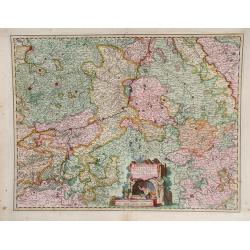
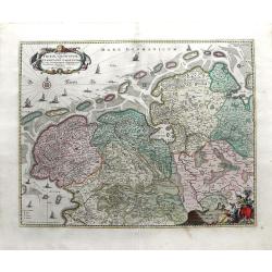
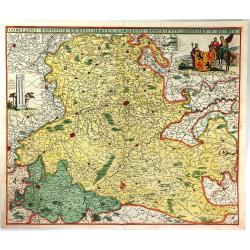
Tabula Geographica qua pars Septentrionalis Sive Inferior Rheni, Mosae, et Mosellae Maximaeque Partes Visorgis, Moeni, Amasi, Scaldis, Isalae, at Alia in Eofdem Influentia Flumina, Necnon, Provinciae Germaniae Inferioris, Westphaliae, Hassiae, Archiepisco
A map depicting the regions between Amsterdam Holland to Frankfurt Germany, which includes major cities such as Munster, Antwerp and Philippville. This wonderfully detail...
Date: Amsterdam, 1680
Selling price: ????
Please login to see price!
Sold in 2010
Carte géographique du duché de Pomeranie et de Mecklenbourg. . .
Decorative map of the provinces of Pomerania and Mecklenburg in Germany. With Lubeck, the island of Rugen, Stettin reaching into modern day's Poland.
Date: Amsterdam, 1680
Selling price: ????
Please login to see price!
Sold in 2011
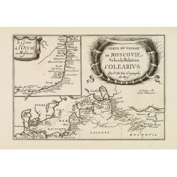
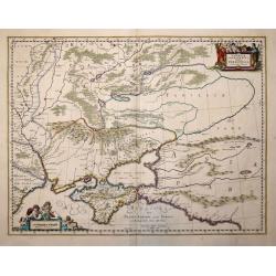
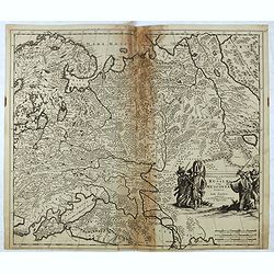
Carte du voyage de Moscovie selon la relation d'Olearius.
Rare map of the region of Baltic sea and the area west of Moscow. With an imposing title cartouche and an inset map "Le cours de l'occa en Moscovie".Basically t...
Date: Paris, 1680
Selling price: ????
Please login to see price!
Sold in 2015
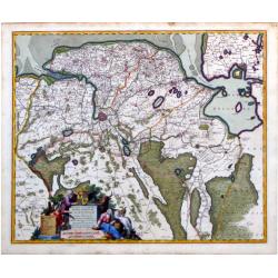
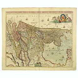
Tabula Frisia, Groninga, et Territorii Emdensis nec non circumjacentium Regionum, puta Transisalaniae, Benthemiae, Westphalae et Oldenburgi
Map of the Friesland and Groningen provinces of northern Holland, including the capital cities of Leeuwarden and Groningen. A beautifully rendered and colored title carto...
Date: Amsterdam, c. 1680
Selling price: ????
Please login to see price!
Sold in 2010
Tabula Dominii Groeningae quae et Complectitur Maximam Partem Drentiae Emendata A.F. De Wit.
Splendid map of the Groningen region of The Netherlands by Frederick de Wit. Small inset maps showing the islands of the region in the top right corner. Shows the cities ...
Date: Amsterdam, 1680
Selling price: ????
Please login to see price!
Sold in 2010
Comitatus Zutphaniae sive Geldriae Tetrachiae Zutphaniensis Isalae Fluvii Correctissima Descriptio denovo revisa, accurate divisa, et edta per F. de Witt
Beautiful map showing the regions of Gelderland, Flevoland and OverIjssel of The Netherlands by Frederick de Wit. The cities of Arnhem, Doesburg, Zutphen, Deventer and Ka...
Date: Amsterdam, c. 1680
Selling price: ????
Please login to see price!
Sold in 2010
Leodiensis Episcopatus Pars Septentrionalis, Comprehendens Comitatum Lossensem et Hornanum
Beautiful map of the Limburg region of Southeastern Netherlands and northern Belgium by Nicolas Visscher. Shows the cities of Maastricht, Hasselt (northern Belgium), Brey...
Date: Amsterdam, c. 1680
Selling price: ????
Please login to see price!
Sold in 2010
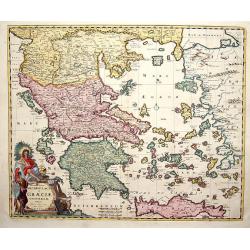
Accurata totius Archipelagi et Graeciae Universae Tabula.
Map of total Greece with all islands.
Date: Amsterdam, 1680
Selling price: ????
Please login to see price!
Sold in 2014
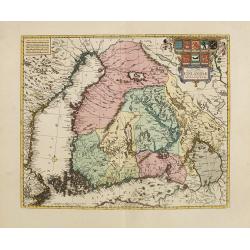
Nova Tabula Magni Ducatus Finlandiae. . .
The map is based on the archetypal map of the Swede Anders Bure. It is the first map to show the Grand-Duchy of Finland on its own. A remarkably beautiful cartouche displ...
Date: Amsterdam, 1680
Selling price: ????
Please login to see price!
Sold in 2010
Ungarn, Siebenbürgen, Wallach, Moldau. . .
Rare map of the Danube River. Surrounded by panoramic views of Vienna, Istanbul, Raab, Hermanstat, Temeswar, Gran, etc. Including Istria, and the coast of former Yugoslav...
Date: Nurenberg, c. 1680
Selling price: ????
Please login to see price!
Sold in 2010
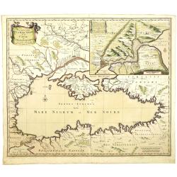
Nouvelle Carte de la Mer Noire et du Canal de Constantinople.
Decorative and uncommon map the Black Sea region. In upper left hand corner an inset map (200x280) of the Bosporus including Istanbul.
Date: Amsterdam, 1680
Selling price: ????
Please login to see price!
Sold in 2011
Regnum Hungaria. . .
Centered on Budapest, with Belgrade in the bottom right.
Date: Amsterdam, 1680
Selling price: ????
Please login to see price!
Sold in 2011
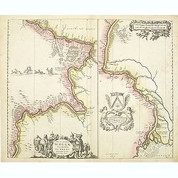
Nova et accurata Wolgae Fluminis olim Rha dicti delineatio Auctore Adamo Oleario.
Showing the Volga River in two parts based on the travels of Adam Olearius. The left side of the map begins at Nazhniy Novgorod and ends at Saratov. The right side contin...
Date: Oxford, 1680
Selling price: ????
Please login to see price!
Sold in 2011
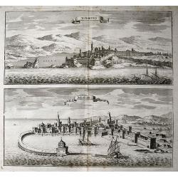
Navarino, Modon.
Two birds- eye town-views on one sheet: Modon and Navarino on the Peloponnese peninsula. Both images show the historically important cities from the seaside with super...
Date: Frankfurt, c1680
Selling price: ????
Please login to see price!
Sold in 2011
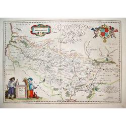
Picardi.
A very well defined map of the Picardi region of France. Two typical regional folk are depicted in the foreground and the royal arms of France are in the top right hand c...
Date: Amsterdam, ca. 1680
Selling price: ????
Please login to see price!
Sold in 2011
Comitatus Flandriae Accuratissima, descriptio,. . .
Uncommon and detailed map of the provinces of Flanders and Brabant in present-day Belgium.Magnificent title- and scale cartouches etched by Romeijn de Hooghe.
Date: Amsterdam, 1680
Selling price: ????
Please login to see price!
Sold in 2014
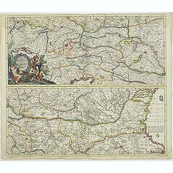
Exactissima Totius DANUBII FLUVII. Tabula et . . .
Two maps on one sheet, showing the course of the River Danube. With Constantinople in the lower right corner. Published by Th. Danckerts. The upper part has a nice origin...
Date: Amsterdam, c.1680
Selling price: ????
Please login to see price!
Sold in 2018
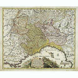
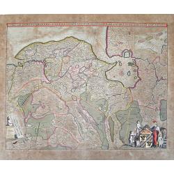
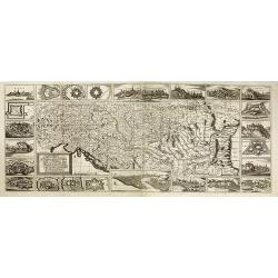
Nova et accurata Ducatus Sabaudiae, Principat. Pedemont. et Montferat., Ducatus Mediolan. et Reipub. Genuensis tabula cum adiacentibus Regionibus itemq. viis, ex Gallia, per Alpes in Italiam ducentibus . . .
Scarce and detailed map of Piedmont et Montferrat. Engraved by Joachim von Sandrart. The artist and art historian Jacob von Sandrart (1630-1708). The Mediterranean is fil...
Date: Nuremberg, c. 1680
Selling price: ????
Please login to see price!
Sold
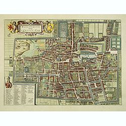
Haga Comitis Vulgo 'S Graven-Hage.
A very RARE bird's-eye town-plan of The Hague. The work was copied after Joan Blaeu.The plan is finely engraved and provides superb detail of the city's important buildin...
Date: Amsterdam, 1680
Selling price: ????
Please login to see price!
Sold in 2012
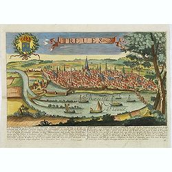
Treves. (Trier)
Rare and decorative view of Tier with the river Meuse in the foreground. Underneath a historical description of the town in Latin and French. The description mentions abo...
Date: Paris, 1680
Selling price: ????
Please login to see price!
Sold in 2024
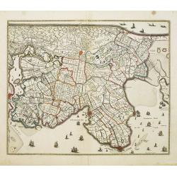
Noordt Hollandt.
A detailed map of the northern part of Holland. At that time practically all polders -with the exception of the IJ-polder- had already been reclaimed.
Date: Amsterdam, 1680
Selling price: ????
Please login to see price!
Sold in 2014
Ultraiectini dominii tabula. . .
Important map of Utrecht. Orientated south/west to the top. With two very decorative cartouches.
Date: Amsterdam, 1680
Selling price: ????
Please login to see price!
Sold in 2014
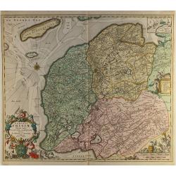
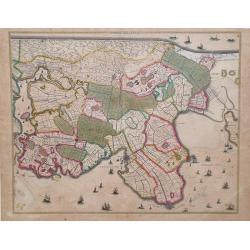
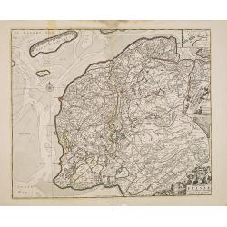
Dominii Frisiae..
This large copper engraved map details the coastline of Friesland and Terschelling. At east is a part of Groningen. The main cities are colored in red. The very decorativ...
Date: Amsterdam ca.1680
Selling price: ????
Please login to see price!
Sold in 2012
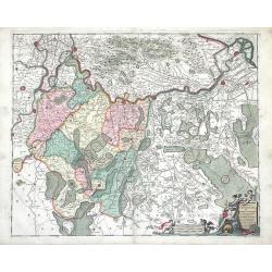
Exactissima Palatinatus Rheni.
Decorative map of the Rhine River valley includes Frankfurt, Manheim, Heidelberg, Ulm, and Durlach. The topography is noted pictorially, and a simple compass rose orients...
Date: Amsterdam ca.1680
Selling price: ????
Please login to see price!
Sold in 2014
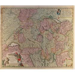
Exactissima Helvetiae..
Very detailed map of Switzerland graphically depicting the mountainous region. Hundreds of tiny villages are named. Decorated with two cartouches, a scale of miles, and a...
Date: Amsterdam ca.1680
Selling price: ????
Please login to see price!
Sold in 2012
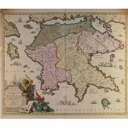
Peloponnesus hodie Morea..
Detailed map of the southern part of Greece, including Peloponnesus, Zakinthos, and Kefallinia. Good detail throughout. Large (colored) cartouche depicting a mythical lio...
Date: Amsterdam ca.1680
Selling price: ????
Please login to see price!
Sold in 2014
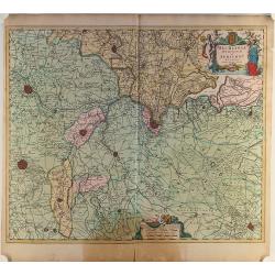
Mechelinia Dominium et Aerschot..
Detailed map of the southern part of The Netherlands and the northern part of Belgium with Antwerp and Brussels. Large (colored) cartouche with a coat of arms and putti.
Date: Amsterdam ca.1680
Selling price: ????
Please login to see price!
Sold in 2014
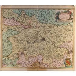
Comitatus Namurci..
Detailed map of a part of Belgium with Namur in the middle. Large (colored) cartouche with putti and one with a coat of arms.
Date: Amsterdam ca.1680
Selling price: ????
Please login to see price!
Sold in 2014
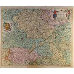
Comitatus Hannoniae..
Detailed map of a part of Belgium with Bergen/Mons in the middle. Large (colored) cartouche with putti and one with a coat of arms.
Date: Amsterdam ca.1680
Selling price: ????
Please login to see price!
Sold in 2014
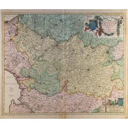
Geographica Artesiae..
Detailed map of a part of France with Calais in the left top corner. Large (colored) cartouche with a coat of arms and putti.
Date: Amsterdam ca.1680
Selling price: ????
Please login to see price!
Sold in 2014
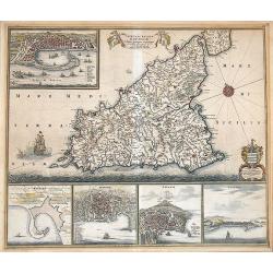
Insula sive Regnum Siciliae Urbibus praecipuis exornatum.
An old color example of De Wit's famous map of Sicily, with the view of Messina, Milazzo, Palermo Catania, and Trapani.It is one of the most decorative maps of Sicily fro...
Date: Amsterdam, 1680
Selling price: ????
Please login to see price!
Sold in 2012
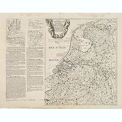
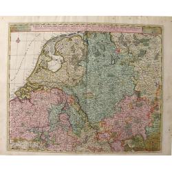
Cartes des provinces unies des Pays Bas connues sous les nom de Hollande. . .
Unrecorded map of the Low Countries, printed from two copper plates by François Jollain (ca. 1641 – 18 April 1704).To the left a detailed description of the Dutch prov...
Date: Paris, ca. 1680
Selling price: ????
Please login to see price!
Sold
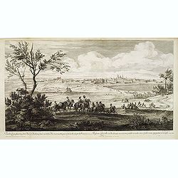
Veue de Leuve, place très-forte dans le Brabant, située au milieu d'un marais, attaquée et forcée de nuit par les François en l'année 1678. . . (Zoutleeuw)
Showing the siege of the town of Zoutleeuw. Showing the French cavalry advancing in the direction of the Sint-Truiden port. Giving a clear picture of the old Holy Cross C...
Date: Paris, ca. 1680
Selling price: ????
Please login to see price!
Sold
Tabula Comitatus Frisiae.
The map was prepared by B.Schotanus à Steringa.
Date: Amsterdam, 1680
Selling price: ????
Please login to see price!
Sold in 2013
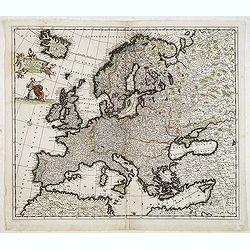
Accuratissima Europae tabula multis locis correcta. . .
Uncommon map of Europe with fine title cartouche.
Date: Amsterdam, c.1680
Selling price: ????
Please login to see price!
Sold in 2013
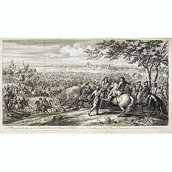
Le Rhin passé à la nage par les François, à la veuë de l'Armée de Hollande, 11 juin 1672.
Showing Louis XIV crossing the Rhine at Lobit at Tolhuis on 11 June 1672. Etching by C. Simmoneau after Adam Frans van der Meulen (1632-1690) who was a Flemish Baroque pa...
Date: Paris, ca. 1680
Selling price: ????
Please login to see price!
Sold in 2021
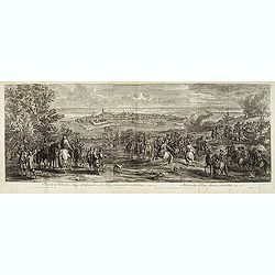
Veuë de la Ville et du Siège d'Oudenarde, ou le Roy commande en personne, en l'année 1667.
Showing the town of Oudenaarde. Etching after Adam Frans van der Meulen (1632-1690) who was a Flemish Baroque painter specializing in battle scenes. He was active first i...
Date: Paris, ca. 1680
Selling price: ????
Please login to see price!
Sold in 2017
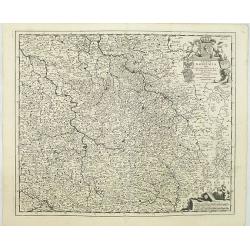
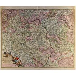
Regnum Bohemia, eique Annexae provinciae uit Ducatus Silesia, Marchionatus Moravia et Lusatia.
Detailed map of Czechoslovakia including parts of Poland, Germany with the towns of Dresden, Prague, Breslau, etc. With fine title cartouche upper left, putti carrying th...
Date: Amsterdam, 1680
Selling price: ????
Please login to see price!
Sold in 2019
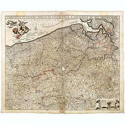
Comitatus Flandriae Tabula in lucem edita.
Map of Flanders, the whole Belgian region northwest of Brussels, confined by Antwerp, Brussels, Valenciennes, Arras, St. Omer and the Channel.Title heading above the map,...
Date: Amsterdam, 1680
Selling price: ????
Please login to see price!
Sold in 2018
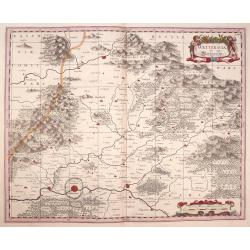
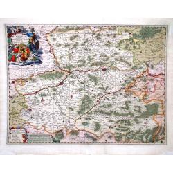
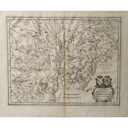
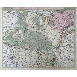
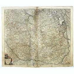
Wetteravia die Wetteraw.
Published in Oxford 1680 by Moses Pitt and Stephen Swart from the map plates by Joannes Janssonius. Uncommon and very beautiful map of the region around Frankfurt. Extre...
Date: Oxford,1680
Selling price: ????
Please login to see price!
Sold in 2016
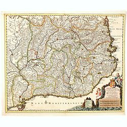
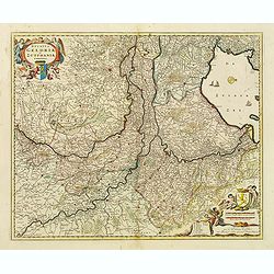
Principatus Cataloniae et Comitatus Ruscinonis et Cerretaniae descriptio
Follows the Mediterranean Coast from Alfactus and Tortosa to the Gulf of Lyon and Leucate. Including Barcelona, Gascogne and Balbastro. Barcelona. The map shows a Catalan...
Date: Amsterdam, 1680
Selling price: ????
Please login to see price!
Sold in 2014
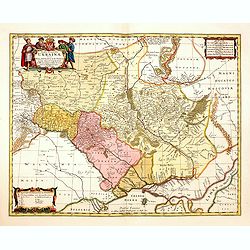
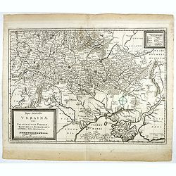
Typus Generalis Ukrainae sive Palatinatuum Podoliae, Kioviensis et Braczlaviensis terras nova delineatione exhibens. . .
Key map based on Guillaume La Vasseur de Beauplan's map of the region published in "Description d'Ukraine". The work described Ukraine as several provinces of t...
Date: Oxford, 1680
Selling price: ????
Please login to see price!
Sold in 2014
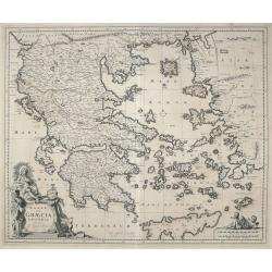
ΕΛΛΑΣ, Seu Graecia Universa Autore J. Laurenbergio.
Highly detailed map of the whole of Greece, the Greek Islands, the Aegean, Crete and part of Asia Minor.
Date: Amsterdam, 1680
Selling price: ????
Please login to see price!
Sold in 2016
Taurica Chersonesus Hodie Przecopsca et Gazara dicitur. . .
Map shows the Ukraine with the island of Crimea.
Date: London,1680
Selling price: ????
Please login to see price!
Sold in 2014
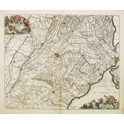
Ducatus Geldriae et Zutphaniae Comitatus.
Map of the Dutch provinces of Gelderland and Noord Brabant. Showing the Ijselmeer (Zuyder Zee), Zwolle, Wesel, Eindhoven and Utrecht. North orientated to the right. Decor...
Date: Amsterdam, ca. 1680
Selling price: ????
Please login to see price!
Sold in 2015
Caerte van Noorwegen vande hoeck van Horrel tot aen Momendael, waer in begrepen wert het Liet van Dronten.
A rare sea Chart shows part of the Norwegian coast, from Horrel to Trondheim. Nice original colors.
Date: Amsterdam, 1680
Selling price: ????
Please login to see price!
Sold in 2018
Regnum Hungaria in omnes suos comitatus accurate divisum et editum.
A rare map of the Kingdom of Hungary and surrounding regions of Austria and Serbia. The city of Budapest is shown at the centre of the map. Relief shown pictorially. Vers...
Date: Amsterdam, 1680
Selling price: ????
Please login to see price!
Sold in 2021
Pascaart van Europa. Alsmede een gedeelte van cust van Africa. . .
A rare chart of Europe's coastline from northern Russia to Yugoslavia in the south, also showing the West Coast of Africa as far as the Cape-Verdian islands.The uncommon ...
Date: Amsterdam, ca. 1680
Selling price: ????
Please login to see price!
Sold in 2015
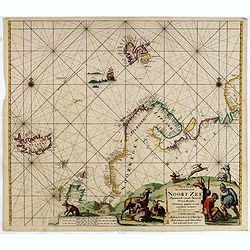
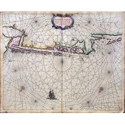
Paskaart Van 't Noordelykste deel der Noort Zee Beginnende van der Neus tot Nova Zembla. . . .
Very fine chart with Iceland to the left and reaching till Nova Zembla, including of Iceland, Spitzbergen, Northern Scotland, Russia and Scandinavia with just a hint of G...
Date: Amsterdam, 1680
Selling price: ????
Please login to see price!
Sold in 2016
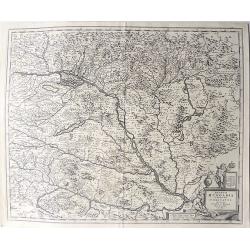
Ducatus Silesiae Glogani Vera Delineatio
A detailed map of Poland showing parts of Silesia with Glogau, Grünberg Guhrau and Schwiebus. Very detailed, especially showing different sizes of cities and towns, fore...
Date: Amsterdam, 1680
Selling price: ????
Please login to see price!
Sold in 2016
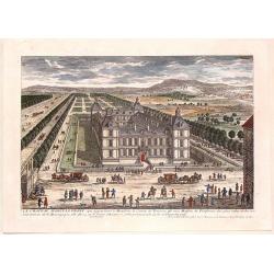
Le Chateau D'Ancy-Le Franc.
Fine hand-colored city view from the book "VIEWS OF THE MOST BEAUTIFUL PLACES OF VERSAILLES" published in Paris by Nicolas Langois in about 1680. The artist was...
Date: Paris, 1680
Selling price: ????
Please login to see price!
Sold in 2015
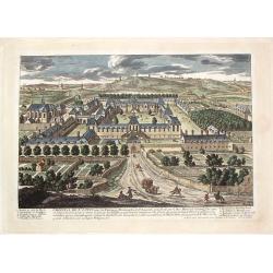
L'Hopital de St. Louis.
Fine hand-colored city view from the book "VIEWS OF THE MOST BEAUTIFUL PLACES OF VERSAILLES" published in Paris by Nicolas Langois in about 1680. The artist was...
Date: Paris, 1680
Selling price: ????
Please login to see price!
Sold in 2016
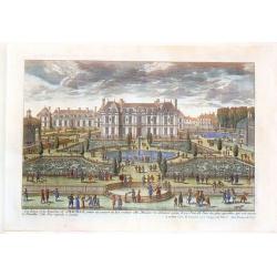
Les Eaux et les Environs de Chauille.
Fine hand-colored city view from the book "VIEWS OF THE MOST BEAUTIFUL PLACES OF VERSAILLES" published in Paris by Nicolas Langois in about 1680. The artist was...
Date: Paris, 1680
Selling price: ????
Please login to see price!
Sold in 2018
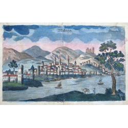
Malaga.
Curious early view of Malaga. Show the town across the river with numouers buildings and towers, the fort also shown on top of the hill. Several sailing ships are depicte...
Date: ca. 1680
Selling price: ????
Please login to see price!
Sold in 2015
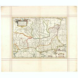
Walachia, Servia, Bulgaria, Romania.
Striking map of the region centered on the Lower Danube, Bulgaria, Romania, Serbia and Macedonia. Includes decorative cartouche, coat of arms, etc. Latin text on verso.Th...
Date: Oxford, 1680
Selling price: ????
Please login to see price!
Sold in 2015
Novissima et Accuratissima Totius Russiae Vulgo Muscoviae Tabula at Iusto Danckerts . . .
Interesting map of Western Russia and Ukraine, published by Justus Danckerts. The map extends from the northern tip of the Black and Caspian Seas to the Mare Mosovia and ...
Date: Amsterdam, 1680
Selling price: ????
Please login to see price!
Sold in 2015
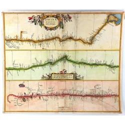
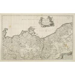
Dwinae Fluvii Nova Deseripio.
An unusual early map, showing the course of the Dvina River in three separate panels in strip map style. With the headwaters at bottom left, and with the mouth at Archang...
Date: Amsterdam, 1680
Selling price: ????
Please login to see price!
Sold in 2016
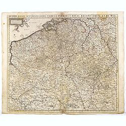
Belgii Regii Accuratissima Tabula Pluribus Locis recens emen: A F. DE Wit.
Covering present-day Belgium, Luxembourg, Noord Brabant an Limburg in the Netherlands, and northern part of France.
Date: Amsterdam, 1680
Selling price: ????
Please login to see price!
Sold in 2016
Comitatus Flandriae Tabula, In Lucem Edita A Frederico De Wit.
Double page map of Flanders, the whole Belgian region northwest of Brussels, confined by Antwerp, Brussels, Valenciennes, Arras, St. Omer and the Channel. Title heading a...
Date: Amsterdam, 1680
Selling price: ????
Please login to see price!
Sold in 2016
Tabula Ducatus Brabantiae continens Marchionatum Sacri Imperii et Dominium Mechliniense emendate à F. de Wit 1666
Shows present-day Belgium and Dutch province of Brabant. Including the Maas and Waal rivers. Shows Antwerp, Brussels, Namur, Liege and Venlo among other towns and cities....
Date: Amsterdam, 1680
Selling price: ????
Please login to see price!
Sold in 2016
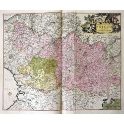
Tabula comitatus Artesiae emendata...
A large-scale map of Nord-Pas-de-Calais, packed with incredible detail. Even the smallest villages are shown, including a network of roads, rivers, forests, etc. With Cal...
Date: Amsterdam, ca 1680
Selling price: ????
Please login to see price!
Sold in 2016
Comitatus Hannonia et Episcopatus Cambresis Descriptio Auctore
A pleasing map of the Belgian region of Hannonia. Adorned with a cartouche including a coat of arms with soldiers on horses surrounding. Also has an interesting vertical ...
Date: Amsterdam, 1680
Selling price: ????
Please login to see price!
Sold in 2016
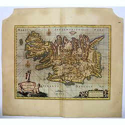
Novissima Islandiae Tabula.
A beautiful map of Iceland, embellished with cartouches, compass roses, rhumb lines, and many other decorative features - all done in the style of Blaeu and Jansson by Mo...
Date: Oxford, 1680
Selling price: ????
Please login to see price!
Sold in 2016
Typus Generalis Ukrainae sive Palatinatuum Podoliae, Kioviensis et Braczlaviensis terras nova delineatione exhibens. . .
Key map based on Guillaume La Vasseur de Beauplan's map of the region published in "Description d'Ukraine". The work described Ukraine as several provinces of t...
Date: Nuremberg, ca. 1680
Selling price: ????
Please login to see price!
Sold in 2016
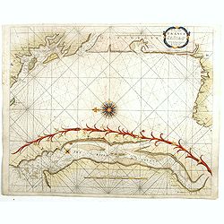
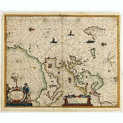
The Sea Coasts of France from Olone to Cape Machiacaca in Biscay.
Detailed chart of Biscay Bay, showing the Coast of Southwestern France and Northwestern Spain, originally engraved by John Seller, here with the address "Sold by Ri....
Date: London, ca. 1680
Selling price: ????
Please login to see price!
Sold
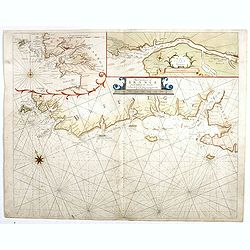
The Sea Coasts of France from Ufhent to Olone . . .
Detailed chart of Biscay Bay, showing the Coast of Brittany. The chart is oriented with north-east at the top and includes two large insets of the Loire River with Nantes...
Date: London, ca. 1680
Selling price: ????
Please login to see price!
Sold
Comitatus Hollandiae. . .
Scarce Danckerts edition of this decorative map of the Netherlands. It includes decorative cartouche, compass rose, coat of arms, sailing ships, etc. Orientated west to t...
Date: Amsterdam, 1680
Selling price: ????
Please login to see price!
Sold in 2017