Browse Listings in Europe
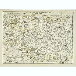
Le duche de Luxembourg et le comte de Namur . . .
The 1675 edition of the copperplate first issued in 1668. Detailed map of the duchy of Luxembourg and including the Belgium region Namur, with the title along the top.Dat...
Date: Paris, 1675
Selling price: ????
Please login to see price!
Sold in 2013
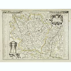
La lorraine et L'Alsace . . .
Detailed map of the French provinces Lorraine and Alsace with fine title cartouche upper right . To the left and right a key to the towns.More about [+]
Date: Paris, 1675
Selling price: ????
Please login to see price!
Sold
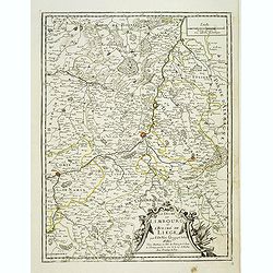
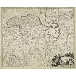
Le duché de Limbourg et l'Eveché de Liege . . .
Detailed map of the duchy of Limburg and diocese of Liege. With fine title cartouche lower right. Dated 1675.More about [+]
Date: Paris, 1675
Selling price: ????
Please login to see price!
Sold in 2019
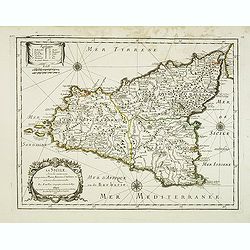
La Sicile, avec les anciens noms de presque toutes ses Places, Rivières, Chateaux &c. et diverses observations nouvelles . . .
Uncommon map of Sicily with fine title cartouche lower right . Dated 1675.More about [+]
Date: Paris, 1675
Selling price: ????
Please login to see price!
Sold in 2012
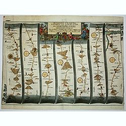
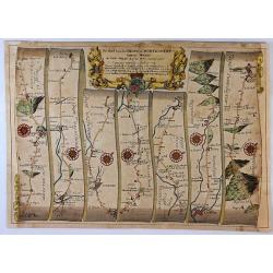
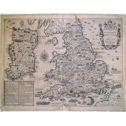
The Continuation of the Road from London to the Lands-end
This map is from John Ogilby's 'Britannia', published between 1675 and 1698. It is a landmark in the mapping of England and Wales. Its unique format constituted the first...
Date: London, 1675
Selling price: ????
Please login to see price!
Sold in 2012
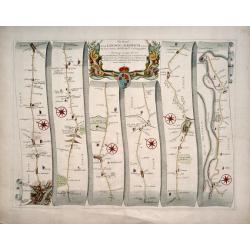
The Road from London to Harwich .
First edition. This strip map is from the "Britannia" by John Ogilby, published in 1675 identified by no sheet number. It is entitled " The Road from Londo...
Date: London, 1675
Selling price: ????
Please login to see price!
Sold in 2014
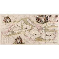
Orientalior tractus Maris Mediterranei. / Orientalior districtus Maris Mediterranei. . .
A fine copy of this beautiful of the Mediterranean lovely color. Centered on Italy, the north coast of Africa and part of the Black Sea. The entire sheet is covered with...
Date: Amsterdam, 1675
Selling price: ????
Please login to see price!
Sold in 2017
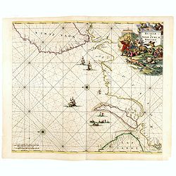
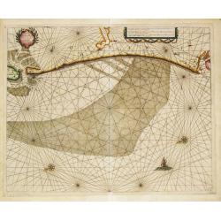
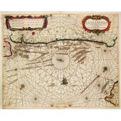
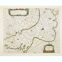
.Russiae et Novae Zemblae Maritimae.
This beautifully, large-scale chart, oriented with east at the top, displays the coastline from northern Russia. Covering the coast from Lapland till the west coast of No...
Date: Amsterdam, 1675
Selling price: ????
Please login to see price!
Sold in 2015
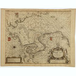
Pas Caart van de Noort Zee Verthoonende in zich alle de Custen en Havens daer rontom gelegen.
An eye-catching chart of the entirety of North Europe's coastline, extending from the Mouth of the Thames and the English Channel and Calais and Dunkirk to Stetin and Chr...
Date: Amsterdam, 1675
Selling price: ????
Please login to see price!
Sold in 2025
Collegium Orlielence (Oriel College)
From ”Oxonia Illustrata”, the first illustrated book on Oxford, and one of the major works of the 17th century.The book was the product of several years of devoted an...
Date: Oxford, 1675
Selling price: ????
Please login to see price!
Sold in 2019
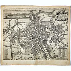
Nova & Accuratissima Celeberrimae Universitatis Civitatisque Oxoniensis Scenographia.
The most prominent historical map of Oxford by David Loggan (1634 - 1692), and has the added cache of having been printed in that city, drafted by a local resident. The m...
Date: Oxford, 1675
Selling price: ????
Please login to see price!
Sold in 2017
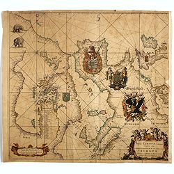
Totius Europae Littora Novissimè edita Pascaert vertoonende alle de See-custen van EUROPA. . .
This beautifully colored, large-scale , oriented with east at the top, displays Europe's coastline from northern Denmark, England to Yugoslavia in the south. A cleverly p...
Date: Amsterdam, 1675
Selling price: ????
Please login to see price!
Sold in 2017
The Road from London To Montgomery North Wales. . .
A sheet showing part of the route from London to Montgomery in Worcestershire that includes the towns of Evesham, Worcester, Ludlow and Montgomery. Taken from John Ogilby...
Date: London, 1675
Selling price: ????
Please login to see price!
Sold in 2017

Carte de la Hongarie a l'Autriche. .
A detailed and scarce map showing Hungary and Austria engraved by de François Lapointe (Lépine). Dated 1664.With a dedication to Ferdinand-Ernest Comte d'Abensperg-Trau...
Date: Paris, 1676
EUROP, and the cheife Cities contayned therin described..
A good impression from an early edition of this famous and decorative cartes-a-figures from the first world atlas produced by an Englishman - John Speed?s Prospect Of The...
Date: London 1676
Selling price: ????
Please login to see price!
Sold
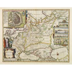
A map of Russia.
One of the most decorative maps of Russia, known for its figured borders with people in local dress, among them a Turkish woman and man. Upper panel of town panoramas of ...
Date: London 1676
Selling price: ????
Please login to see price!
Sold
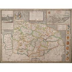
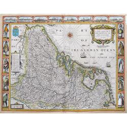
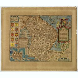
NORFOLK A COUNTIE FLORISHING & POPULOUS DESCRIBED AND DEVIDED WITH THE ARMES OF SUCH NOBLE FAMILIES AS HAVE BORNE THE TITLES THEREOF.
John Speed's fine map of county published in London by Bassett & Chiswell 1676. The map is embellished with an inset town plan of Norwich, the royal arms with support...
Date: London 1676
Selling price: ????
Please login to see price!
Sold in 2013
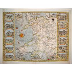
Wales
This is a spectacular and sought after map of Wales by John Speed. Considered to be the most decorative map of the country ever published. The work contains twelve large ...
Date: London, ca. 1676
Selling price: ????
Please login to see price!
Sold
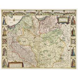
A Newe mape of Poland Done into English by I.Speede.
A wonderful map of Poland. Incorporated into Speed's 'Prospect Of The Most Famous Parts Of The World'. Includes birds-eye views of Cracow, Dantzick, Posna, Crossen, Sando...
Date: London 1676
Selling price: ????
Please login to see price!
Sold
Cust van Hollant Tusschen de Maes ende Texel.
A sea-chart of the coast of Holland with the "Bree Veertien", the large shallow which lays before the coast. Embellished with two cartouches, a ship and two com...
Date: Amsterdam, 1676
Selling price: ????
Please login to see price!
Sold in 2019
De Cust van Zeeland.
Theunis Jacobsz, Amsterdam-based maritime publisher added Lootsman (pilot) to his name. After his death in 1650, his sons Jacob Theunisz and Casparus continued the firm. ...
Date: Amsterdam, 1676
Selling price: ????
Please login to see price!
Sold
De Cust van Vlaenderen, vande Wielingen to aenden Hoofde.
Theunis Jacobsz, Amsterdam-based maritime publisher added Lootsman (pilot) to his name. After his death in 1650, his sons Jacob Theunisz and Casparus continued the firm. ...
Date: Amsterdam, 1676
Selling price: ????
Please login to see price!
Sold in 2008
The Invasions of England and Ireland ...
A finely engraved map with an attractive title cartouche that is surmounted by royal arms, a compass rose and rhumb lines. The content of this map features the invasions ...
Date: London, 1676
Selling price: ????
Please login to see price!
Sold in 2009
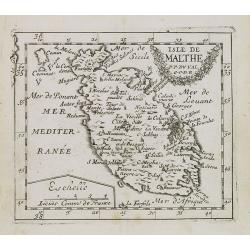
Isle de Malthe.
Uncommon miniature map of Malta from Pierre Duval's La Geographie Universeille dated 1676. Following his Cartes de geographie in 1657, Pierre Duval published this smaller...
Date: Paris, 1676
Selling price: ????
Please login to see price!
Sold in 2008
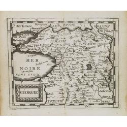
Géorgie.
Uncommon miniature map of Georgia from Pierre Duval's La Geographie Universeille dated 1676. Following his Cartes de geographie in 1657, Pierre Duval published this small...
Date: Paris, 1676
Selling price: ????
Please login to see price!
Sold in 2008
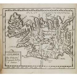
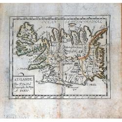
L'Islande.
Uncommon miniature map of Iceland from Pierre Duval's La Geographie Universeille. Following his Cartes de geographie in 1657, Pierre Duval published this smaller size atl...
Date: Paris, 1676
Selling price: ????
Please login to see price!
Sold in 2008
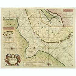
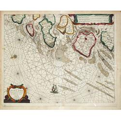
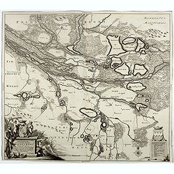
Pascaerte van de Mont van de Witte Zee tot aen de Rivier van Archangel..
Beautiful and rare chart from Nieuw en Groote Loots-Man Zee Spiegel, Ofte lichtende Colomme. Showing the mount of the White Sea. In upper right hand corner inset map of &...
Date: Amsterdam, 1676
Selling price: ????
Please login to see price!
Sold in 2011
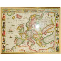
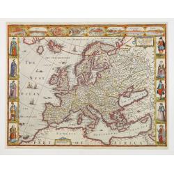
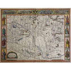
Europ, and the chiefe Cities contayned yjerin, described; with the habits of most Kingdoms now in use. By Jo. Speed Ano Dom 1626
An exceptional example of John Speed's sought-after map of Europe, bordered by images of various European ethnicities in traditional 17th century dress. Along the top por...
Date: London, ca. 1676
Selling price: ????
Please login to see price!
Sold in 2012
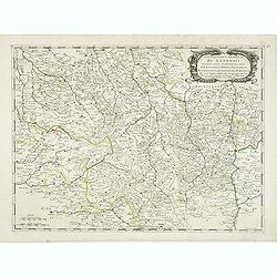
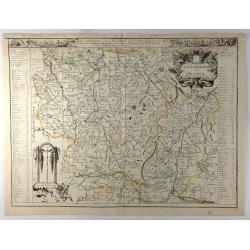
Gouvernement général du Lyonnois suivant les derniers Estats generaux ou sont le Lyonnois . . .
Fine map of central part of France centered on Clermont-Ferrand and with Lyon in the most eastern part of the map.This edition has no date and carries the address of Pier...
Date: Paris, 1676
Selling price: ????
Please login to see price!
Sold
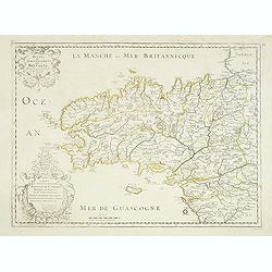
Duche et Gouvernement de Bretagne.
Fine map of Bretagne, including the cities of Nantes, Rennes, Belle-Île, etc. engraved by R. Cordier d'Abbauil. The map is still dated 1650. In the dedicational cartouch...
Date: Paris, 1676
Selling price: ????
Please login to see price!
Sold in 2012
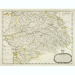
Gouvernement General d'Orleans . . .
Fine map of south eastern part of France, centered on the river Loire, including Isle d'Ré, S.Malo and Paris in the upper right corner. This edition carries the date 165...
Date: Paris, 1676
Selling price: ????
Please login to see price!
Sold in 2012
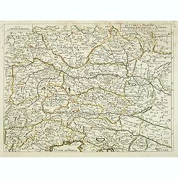
Le Cours du Danube ou sont la Baviere, l'Austriche et la Boheme. . .
A detailed and scarce map showing the river Danube from Hungary until its source in Germany. In lower part the Gulf of Trieste with Venice.
Date: Paris, 1676
Selling price: ????
Please login to see price!
Sold in 2013
![L'Italie par P. Du-Val. . . [4 sheet wall map]](/uploads/cache/31972-250x250.jpg)
L'Italie par P. Du-Val. . . [4 sheet wall map]
One of Du Vals magnificent wall maps included in his atlas "Cartes de Geographie" and could be mounted and used as a wall map.Dated 1675. Engraved by Francois C...
Date: Paris, 1675-1676
Selling price: ????
Please login to see price!
Sold
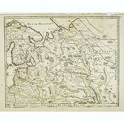
Moscovie dîte autrement la Grande Blanche Russie . . .
Detailed map by Pierre du Val of the European part of Russia including Finland, Poland and the Baltics with title along the bottom.This is the uncommon early edition with...
Date: Paris, 1676
Selling price: ????
Please login to see price!
Sold in 2014
Pascaarte van de Witte Zee begrypende de custen van Laplant..
Beautiful chart of the White Sea from Nieuw en Groote Loots-Man Zee Spiegel, Ofte lichtende Colomme. Showing the White Sea.The family name of the Lootsman brothers is The...
Date: Amsterdam, 1676
Selling price: ????
Please login to see price!
Sold in 2012
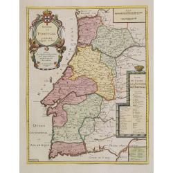
Royaume de Portugal.
From his first edition of his only folio atlas. Engraved by N.Michu.Uncommon map of Portugal, with fine title cartouche upper left and to the right a list of the Portugue...
Date: Paris 1676
Selling price: ????
Please login to see price!
Sold in 2013
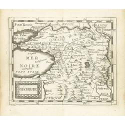
Géorgie.
Scarce miniature map of Georgia from Pierre Duval's La Geographie Universeille dated 1676. Following his Cartes de geographie in 1657, Pierre Duval published this smaller...
Date: Paris, 1676
Selling price: ????
Please login to see price!
Sold in 2015
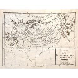
Carte de la Russie Asiatique ou Tartarie Russe.
Fine copper engraved engraving featuring the Eastern part of Russia. Engraved by Brion de la Tour and published in "HISTOIRE UNIVERSELL" by Chez Moutard in 1676...
Date: Paris, 1676
Selling price: ????
Please login to see price!
Sold in 2014
L'Islande par P. Du Val Geographe du Roy a Paris.
A nice, rare miniature map of Iceland from Pierre Duval's "La Geographie Universeille". Duval published a very small sized atlas containing a large number of ma...
Date: Paris, 1676
Selling price: ????
Please login to see price!
Sold in 2016
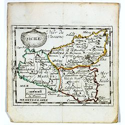
Sicile.
Scarce miniature map of Sicily from Pierre Duval's La Geographie Universeille. Following his Cartes de géographie in 1657, Pierre Duval published this smaller size atlas...
Date: Paris, 1676
Selling price: ????
Please login to see price!
Sold in 2020
Delineationem Liberae in silesia dynastiae Drachenberg . . .
Scarce map by Johann Christian Berger, of the Barony of Żmigród (=Drachenberg) with nearby fortress and sizable baroque garden, both surrounded by waters of Bar...
Date: Amsterdam, 1676
Selling price: ????
Please login to see price!
Sold in 2017
![[untitled] Sicily.](/uploads/cache/98041-250x250.jpg)
[untitled] Sicily.
Rare map of ancient Sicily from Raleigh's History of the World. The double page map shows the island in a large scale and good detail. Shows a number of towns, rivers and...
Date: London, 1614-1676
Selling price: ????
Please login to see price!
Sold in 2017
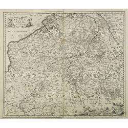
A New Mape of ye XVII Provinces of Low Germanie, mended a New in manie places.
Fantastic and important Carte-à-figures map of the Low Countries. With eight city views showing Amsterdam, Antwerp, Ghent, Middelburg, Groeningen, Zutphen, Utrectht and ...
Date: London, 1676
Selling price: ????
Please login to see price!
Sold in 2017
The Countye Palatine with the most ancient citie described.
The excellent county map of Cheshire, first published in Speed's “Theatre of Empire” in 1611, this is the 1676 edition with the Bassett & Chiswell imprint. The ma...
Date: London, 1676
Selling price: ????
Please login to see price!
Sold in 2020
La Lorraine et l'Alsace.
A detailed 1676 copper engraved map of the French wine-making region of Lorraine and Alsace by Du Val. It covers the northeast portion of France along with parts of neigh...
Date: Paris, 1676
Selling price: ????
Please login to see price!
Sold in 2020
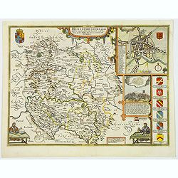
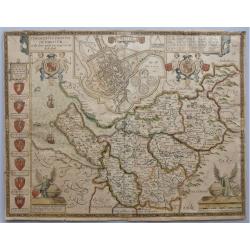
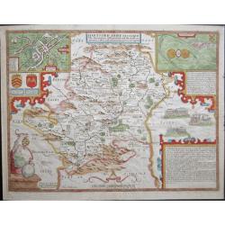
Herefordshire described. . .
The 1676 edition map of Herefordshire by John Speed, and published by Bassett & Chiswell in London. A decorative English county map, embellished with strapwork title ...
Date: London, 1676
Selling price: ????
Please login to see price!
Sold in 2020
The Countie and Citie of Lyncolne. . .
John Speed's attractive map of Lincolnshire. Published at the back end of the seventeenth century by Basset & Chiswell in London. The left of the map features a town ...
Date: London, 1676
Selling price: ????
Please login to see price!
Sold in 2021
The Mape of Hungari newly augmented by John Speede.
A wonderful map of Hungary. Incorporated into Speed's 'Prospect Of The Most Famous Parts Of The World'. Showing 2 sets of 4 costumed figures on each side of the map and v...
Date: London, 1676
Selling price: ????
Please login to see price!
Sold in 2019
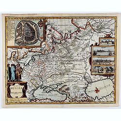
A map of RUSSIA.
A good impression from an early edition of this famous and decorative cartes-a-figures of Russia from the first world atlas produced by an Englishman - John Speed’s Pro...
Date: London 1676
Selling price: ????
Please login to see price!
Sold in 2021
'Hartford Shire described, The situations of Hartford and the most ancient towne S.Albons with such memorable actions as have happened'
Full title as it appears at the top of the map: 'Hartford Shire described, The situations of Hartford and the most ancient towne S.Albons with such memorable actions as h...
Date: London, 1676
Selling price: ????
Please login to see price!
Sold in 2020
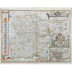
Essex, devided into Hundreds...
Speed's famous map of Essex. From London until Harwich. With an inset plan of Colchester. Richly decorated with coats of arms and seals, sailing ships, a sea-monster, and...
Date: London, 1676
Selling price: ????
Please login to see price!
Sold in 2023
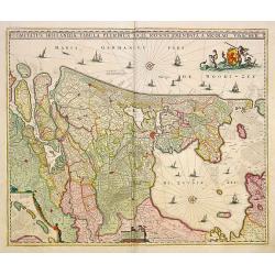
Comitatus Hollandiae Tabula Pluribus Locus Recens Emendata a Nicolao Visscher.
West to the top. Very fine map of the province of Holland, here in a 4th state.
Date: Amsterdam 1677
Selling price: ????
Please login to see price!
Sold in 2015
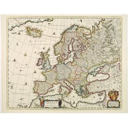
Europa Delineata et Recens Edita.
This map of Europe is particularly attractive: finely engraved with discreet decorative sailing ships, monsters and compass roses adorning the seas.In the lower right han...
Date: Amsterdam 1677
Selling price: ????
Please login to see price!
Sold
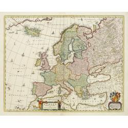
Europa Delineata et Recens Edita.
This map of Europe is particularly attractive: finely engraved with discreet decorative sailing ships, monsters and compass roses adorning the seas.In the lower right han...
Date: Amsterdam, 1677
Selling price: ????
Please login to see price!
Sold in 2014
Belgii Regii accuratissima Tabula, Auctore Nicolao Visscher.
Map of mainly present-day Belgium. Taken from the atlas Germania Inferior, sive XVII Provinciarum Geographicae generales ut et particulares tabulae. Kaert-Boeck van de XV...
Date: Amsterdam, 16856-1677
Selling price: ????
Please login to see price!
Sold in 2015
Dominii Groningae nec non maximae partis Drentiae Novissima. Delineatio per Nicolaum Visscher.
Map of Groningen and Drenthe in the north-east part of the Netherlands. Inset upper right corner of the "Wadden eilanden" entitled Caerte van de Groeninger Eyla...
Date: Amsterdam, 16856-1677
Selling price: ????
Please login to see price!
Sold in 2009
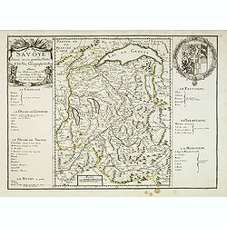
La Savoye divisée en ses Grandes Parties . . .
Detailed map of the province Savoie with fine title cartouche left and coat of arms to the right. Detailed key notions and fine arms right. More about [+]
Date: Paris, 1677
Selling price: ????
Please login to see price!
Sold
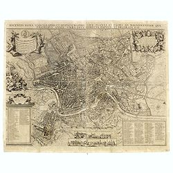
Recentis romae ichnographia et hypsographia. . .
A very rare bird's-eye-view of Rome, cartouches, inset illustrations of important churches and basilicas at foot. Engraved by Johan Meyer and published by Johannes Sandra...
Date: Nurenberg, 1677
Selling price: ????
Please login to see price!
Sold in 2016
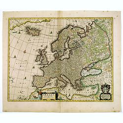
Europa Delineata et Recens Edita.
This map of Europe is particularly attractive: finely engraved with discreet decorative sailing ships, monsters and compass roses adorning the seas. Map is filled with pl...
Date: Amsterdam, 1677
Selling price: ????
Please login to see price!
Sold in 2017
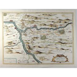
Duche D'Aiguillon.
A striking, unusual 1677 copper engraved regional map of France. Centred on the town of Aiguillon, the map covers the region of Lot-et-Garonne. The map provides excellent...
Date: Paris, 1677
Selling price: ????
Please login to see price!
Sold in 2019
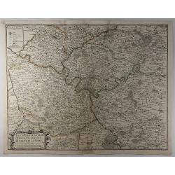
L'Isle de France, le Valois, le Vexin-Francois, le Hurepoix et le Brie.
A highly detailed copper engraved map of the Île-de-France region of France. Centred on Paris, the map is filled with topographic details including cities, towns, villag...
Date: Paris, 1677
Selling price: ????
Please login to see price!
Sold in 2019
![Pictaw in Italia. [Italy].](/uploads/cache/13814-250x250.jpg)
Pictaw in Italia. [Italy].
A very nice panoramic view of the city of Pictaw . On the foreground, a man firering a canon. With a verse in two languages underneath the picture.The poet Daniel Meisner...
Date: Frankfurt 1623-1678
Selling price: ????
Please login to see price!
Sold
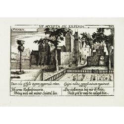
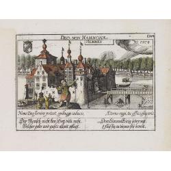
Nyenroy.
View of the castle of Nijenrode. With a verse in two languages underneath the picture.The poet Daniel Meisner from Komotau started his Thesaurus Philo-Politicus. Das ist ...
Date: Frankfurt 1623-1678
Selling price: ????
Please login to see price!
Sold
![Hardales in Hispanien. [Ardales]](/uploads/cache/13745-250x250.jpg)
Hardales in Hispanien. [Ardales]
View of the city of Ardales, northwest of Malaga. With a verse in two languages underneath the picture.The poet Daniel Meisner from Komotau started his Thesaurus Philo-Po...
Date: Frankfurt 1623-1678
Selling price: ????
Please login to see price!
Sold
![Boulenham. [ Burg Boelenham in Betuwe ]](/uploads/cache/13761-250x250.jpg)
Boulenham. [ Burg Boelenham in Betuwe ]
A very nice view of Burg Boelenham in the Betuwe, with fine details of the forest. On the foreground, a man holding a pair of scales is depicted. With a verse in two lang...
Date: Frankfurt 1623-1678
Selling price: ????
Please login to see price!
Sold in 2018
![Slan in Bohmen. [Slany]](/uploads/cache/13763-250x250.jpg)
Slan in Bohmen. [Slany]
A very nice view of the city of Slany in Bohemia. In the foreground, a cloud symbolizing God, shining on a heart hold by a kneeling person. To the left a table with books...
Date: Frankfurt 1623-1678
Selling price: ????
Please login to see price!
Sold
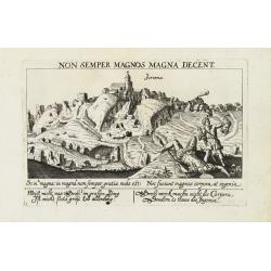
Ferenna. [Gerena near Seville)
A very nice view of the town of Gerena near Seville. With a verse in two languages underneath the picture.The poet Daniel Meisner from Komotau started his Thesaurus Philo...
Date: Frankfurt 1623-1678
Selling price: ????
Please login to see price!
Sold
![Toutenburg. [near Vollenhoven]](/uploads/cache/13795-250x250.jpg)
Toutenburg. [near Vollenhoven]
A very nice view of the castle of Toutenburg near Vollenhoven. Beside the castle a farmhouse with sheep\'s, a cow and wind mill are depicted. With a verse in two language...
Date: Frankfurt 1623-1678
Selling price: ????
Please login to see price!
Sold in 2009
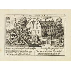
Sinderen.
A very nice view of the castle of Sinderen. With a verse in two languages underneath the picture.The poet Daniel Meisner from Komotau started his Thesaurus Philo-Politicu...
Date: Frankfurt 1623-1678
Selling price: ????
Please login to see price!
Sold
![Rezo. [Reggio di Calabria]](/uploads/cache/13808-250x250.jpg)
Rezo. [Reggio di Calabria]
A very nice picture representing the city of Reggio di Calabria. On the foreground, a ship sinking is depicted. With a verse in two languages underneath the picture.The p...
Date: Frankfurt 1623-1678
Selling price: ????
Please login to see price!
Sold
![Negroponte in Morea. [Chalkis].](/uploads/cache/13831-250x250.jpg)
Negroponte in Morea. [Chalkis].
A very nice picture representing the walled city of Chalkis. On the foreground, Alexander and Thais are depicted. With a verse in two languages underneath the picture.The...
Date: Frankfurt 1623-1678
Selling price: ????
Please login to see price!
Sold
Hemmen.
A very nice view of the castle Hemmen. On the foreground, a man is depicted and to the right the river de Linge. With a verse in two languages underneath the picture.The ...
Date: Frankfurt, 1623-1678
Selling price: ????
Please login to see price!
Sold in 2018
![Dormalle in Brab. [Dormael].](/uploads/cache/13748-250x250.jpg)
Dormalle in Brab. [Dormael].
A very nice view of the castle of Dormalle. On the foreground, a snake and a rat are depicted. With a verse in two languages underneath the picture.The poet and topograph...
Date: Frankfurt, 1623-1678
Selling price: ????
Please login to see price!
Sold in 2017

Insula Islandia.
Uncommon derivative of this miniature map of Iceland, earlier published in Pierre Duval's La Geographie Universeille.The copper plate is newly engraved, and the name of D...
Date: Nuremberg, 1678
Selling price: ????
Please login to see price!
Sold in 2016
![S. Laurens in Franckr. [France].](/uploads/cache/13752-250x250.jpg)
S. Laurens in Franckr. [France].
A very nice view of the town of Laurens in Alsace, with a church. On the foreground, an elephant and a rhinoceros are depicted. With a verse in two languages underneath t...
Date: Frankfurt, 1623-1678
Selling price: ????
Please login to see price!
Sold in 2010
![Negroponte in Morea. [Chalkis].](/uploads/cache/13805-250x250.jpg)
Negroponte in Morea. [Chalkis].
A very nice picture representing the walled city of Chalkis. On the foreground, Alexander and Thais are depicted. With a verse in German and Latin underneath the picture....
Date: Frankfurt, 1623-1678
Selling price: ????
Please login to see price!
Sold in 2008
Lovenstein.
A very nice view of the castle. On the sky, three hands holding a quill, a stone and a stick are depicted. With a verse in two languages underneath the picture.The poet D...
Date: Frankfurt, 1623-1678
Selling price: ????
Please login to see price!
Sold in 2023
![Nonclutz. [Hampton Court near London]](/uploads/cache/91839-250x250.jpg)
Nonclutz. [Hampton Court near London]
A very nice depiction of Hampton Court castle near London. In the foreground a pelican, a doe, a rabbit, a fox and a wild cat. With a verse in two languages underneath th...
Date: Frankfurt, 1623-1678
Selling price: ????
Please login to see price!
Sold in 2011
![Vindesor in Engellandt [Windsor castle near London]](/uploads/cache/91840-250x250.jpg)
Vindesor in Engellandt [Windsor castle near London]
A very nice depiction of Windsor Castle near London. In the foreground a shepherd and a court guard. With a verse in two languages underneath the picture. The poet and ...
Date: Frankfurt, 1623-1678
Selling price: ????
Please login to see price!
Sold in 2011
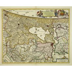
Rhenolandia, Amstelandia et Circumjacentia aliquot Territoria, cum Aggeribus omnibus Terminisq . . .
Decorative folio map of the region surrounding Amsterdam orientated with north to the right edge, encompassing Haarlem, Leiden, The Hague and Gouda. Blank on verso. Certa...
Date: Amsterdam, c.1678
Selling price: ????
Please login to see price!
Sold in 2012