Browse Listings in Europe
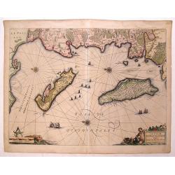
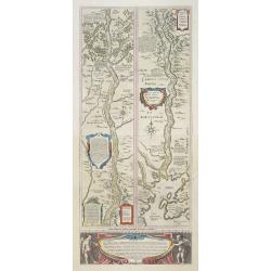
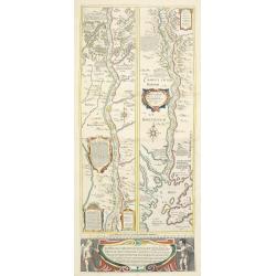
Insulae Divi Martini et Uliarus Vulgo L'Isle de Re et Oleron.
Detailed chart if Ile de Re and Ile d'Oleron with the coast line around La Rochelle. North is oriented to the left instead of up. Decorative title cartouche with a putti ...
Date: Amsterdam, 1636
Selling price: ????
Please login to see price!
Sold in 2016
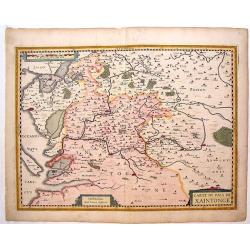
Carte du Pais de Xaintonage.
Copper engraved map of Saintonge, France showing cities such as La Rochelle, Pons, Marans, etc. Two striking title cartouches with cities depicted in detail as miniature ...
Date: Amsterdam, 1636
Selling price: ????
Please login to see price!
Sold in 2015
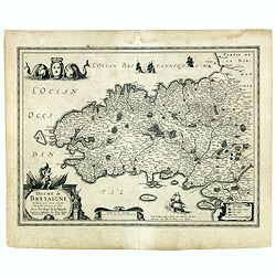
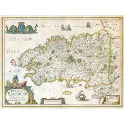
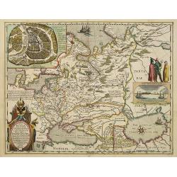
Duche de Bretaigne Designé par le Sieur Hardy Mareschal des logis du Roy. . .
Detailed map of Bretagne in a first state. Here with the double signature of Hondius and Tavernier. After 1636 the signature of Hondius was replaced by Janssonius and sig...
Date: Amsterdam/ Paris, ca. 1630-1636
Selling price: ????
Please login to see price!
Sold
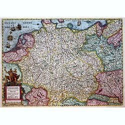
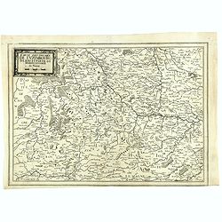
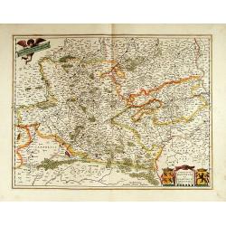
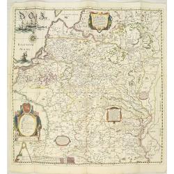
Germaniae nova et accurata delineatio.. 1631.
Very decorative example of Hondius' map of the German Empire, extending from the Low Countries in the Northwest to the Baltic and Russia in the Northeast and Italy and th...
Date: Amsterdam, 1636
Selling price: ????
Please login to see price!
Sold in 2019
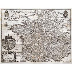
Gallia. Le Royaume de France. Franckreych.
Merian's very decorative and detailed map of France and Switzerland. Richly embellished with coats of arms, a compass rose, and the title cartouche.
Date: Frankfurt, ca. 1636
Selling price: ????
Please login to see price!
Sold in 2016
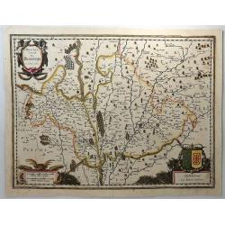
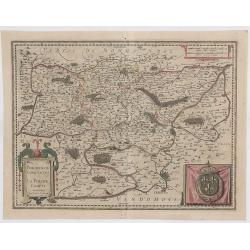
Description de Blaisois.
This antique engraved map originates from a rare two volume Hondius / Janssonius Atlas: Atlas, das ist, Abbildung der Gantzen Welt ..... The Blésois is a French natural ...
Date: Amsterdam, 1636
Selling price: ????
Please login to see price!
Sold in 2018
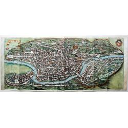
Roma.
An exceptionally colored example of Merian's very decorative view of Rome. Merian's panoramic view of Rome is based on the eastward-oriented model established by Antonio ...
Date: Frankfurt, 1636
Selling price: ????
Please login to see price!
Sold in 2018
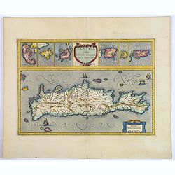
Candia cum Insulis aliquot circa Graeciam.
An attractive (if rather inaccurate) map of Crete, with insets of the islands of Corfu, Zante, Milos, Nicsia, Santorini, and Scarpanto.
Date: Amsterdam, ca 1636
Selling price: ????
Please login to see price!
Sold in 2018
Albis Fluvius Germaniae celebris A Fontibus Ad Ostia. . .
A nice original colored map showing the course of the Elbe River in Germany from the North Sea to Prague. By the famous Dutch cartographer Jan Jansson. The map Includes t...
Date: Amsterdam, 1636
Selling price: ????
Please login to see price!
Sold in 2019
Perchensis Comitatus, La Perche Compte Amstlelodami.
A highly detailed 1636 Jansson map of the former province of Perche, France. It features a strap work title cartouche, a drape including a large Royal armorial and a str...
Date: Amsterdam, 1636
Selling price: ????
Please login to see price!
Sold in 2023
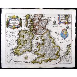
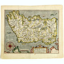
Magnae Britanniae et Hiberniae Tabulae
A handsome map of Britain and Ireland, published by M. Merian in Frankfurt in 1636.Merian based this map on Blaeu's influential earlier work and he added a Stuart coat of...
Date: Frankfurt, 1636
Selling price: ????
Please login to see price!
Sold in 2023
Duche de Bretagne.
Janssonius' Brittany map.
Date: Amsterdam, 1637
Selling price: ????
Please login to see price!
Sold in 2009
La Principaute D'Orange et combat de Venaissin.
Very decorative copper engraved map featuring the cities of Avignon and Orange, as well as several smaller villages. The mountainous and forested topography is graphicall...
Date: Amsterdam, 1637
Selling price: ????
Please login to see price!
Sold
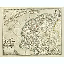
Frisia occidentalis.
This fine map of Friesland was made by the Franeker scientist Adrian Metius. The main towns are shown by miniature plan, attractive title cartouche bottom left, key carto...
Date: Amsterdam, 1637
Selling price: ????
Please login to see price!
Sold in 2012
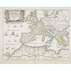
Romani Imperii Qua Occidens est Descriptio Geographica. . .
A fine map of the Roman Empire and includes Europe, Northern Africa, and the Near and Middle East. The map is embellished with ships in the Atlantic and a fine title cart...
Date: Paris, after 1637
Selling price: ????
Please login to see price!
Sold
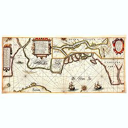
Pascaarte vande witte zee, vertoonende de rechte ghelegentheijt vande zeecusten, mitsgaders aller Havenen, Inwijcken, . . .
Very rare chart by Willem (Jansz) Blaeu from his chart book "Het Licht der Zee-vaert". The complete title of the map reads : "Pascaarte vande witte zee, ve...
Date: Amsterdam, 1608-1637
Selling price: ????
Please login to see price!
Sold in 2014
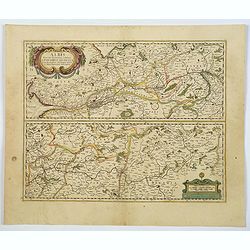
Carte des Duches de Luxembourg Iuliers et Partie de Brabant et Comte de Namur.
Detailed map of Luxembourg, published in "Theatre des Gaules", in 1637. Interestingly the title is printed from a separate copper plate. No date or publishers n...
Date: Paris, 1637
Selling price: ????
Please login to see price!
Sold
Viri Clarissimi Britannia..
A very attractive and decorative early 17th century map of Ireland which appeared in William Camden's Britannia. Based on Mercator's map of 1595, it was engraved by Willi...
Date: London, W.Hole, ca. 1637
Selling price: ????
Please login to see price!
Sold in 2015
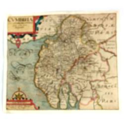
Cumbria Sive Cumberlandia Quae Olim par Brigantum.
A pleasing map of Cumberland from “Camden’s Britannia”. The 'Britannia' was the first publication that contained a complete set of individual county maps of England...
Date: London, 1610-1637
Selling price: ????
Please login to see price!
Sold in 2016
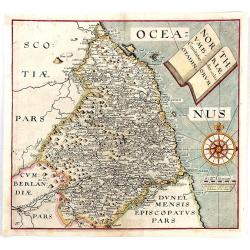
Northumbriae Comitatus, Olim Sedes Otadinorum.
An attractive map of Northumberland based on the first survey of England and Wales by Christopher Saxton and published in William Camden's “BRITANNIA” (London: 1607-...
Date: London, 1610-1637
Selling price: ????
Please login to see price!
Sold in 2016
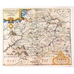
Montgomery Comitatus Qui Osim Pars Ordovicum.
Fine copper engraving of the county of Montgomery in England. The title is in a strapwork cartouche. Prepared and engraved by William Kip and William Hole based on Chris...
Date: London, 1637
Selling price: ????
Please login to see price!
Sold in 2016
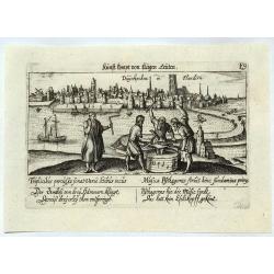
Duynkirchen in Flandern.
A city view of Dunkerque in Flanders based on that of Braun & Hogenberg. Published in Nuremberg by Paulus Furst. From 'Sciographia Cormica'.The authors of this work ...
Date: Nuremberg, 1637
Selling price: ????
Please login to see price!
Sold in 2021
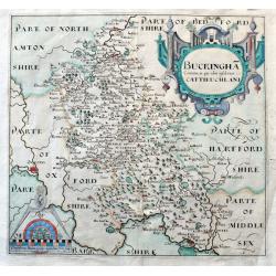
Buckingha Comitatus, in quo olim insederunt Cattieuchlani.
A fine early map of Buckinghamshire engraved by William Hole after Christopher Saxton. From the 1607 or 1637 edition of Camden's 'Britannia'. Very detailed, extending fro...
Date: London, 1637
Selling price: ????
Please login to see price!
Sold in 2020
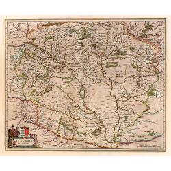
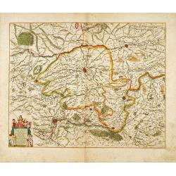
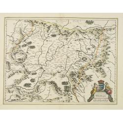
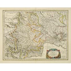
Hungaria Regnum.
Detailed map of Hungary centered on Budapest. Including the towns of Vienna, Zagreb as well.
Date: Amsterdam 1638
Selling price: ????
Please login to see price!
Sold

Jutia Septentrionalis.
Early and detailed map of Jutland. Prepared by Gerard Mercator.
Date: Amsterdam 1638
Selling price: ????
Please login to see price!
Sold
Lutzenburg Ducatus.
Fine map of Luxembourg.
Date: Amsterdam 1638
Selling price: ????
Please login to see price!
Sold
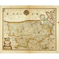
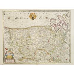
Comitatus Flandriae nova Tabula.
Fine map of flanders showing Bruges, Gant, Bruxelles, Anvers and Bergen op Zoom.In original outline line color, with some later color additions.
Date: Amsterdam 1638
Selling price: ????
Please login to see price!
Sold in 2014
Pars Flandriae orientalis..
Detail of the eastern part of Flemish Flanders: the Liberty of Bruges with the island of Cadzand. Including the towns of Ghent, Sluis, Bruges and Ostend.In original outli...
Date: Amsterdam 1638
Selling price: ????
Please login to see price!
Sold
Flandria Gallica..
Detail of the southern part of Flanders centered on Lille.
Date: Amsterdam 1638
Selling price: ????
Please login to see price!
Sold
![[Untitled chart of Flanders]](/uploads/cache/15777-250x250.jpg)
[Untitled chart of Flanders]
Fine map of flanders showing Bruges, Gant, Bruxelles and Anvers.
Date: Amsterdam 1638
Selling price: ????
Please login to see price!
Sold
Comitatuum Hannoniae et Namurci..
Southern part of Belgium, including Namen and Henegouwen.
Date: Amsterdam 1638
Selling price: ????
Please login to see price!
Sold
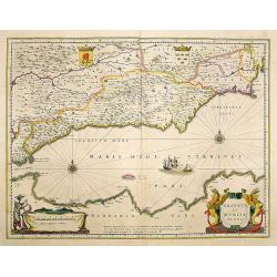
Granata et Murcia regna.
A fine copy decorated with the Arms of both States and the figure of a surveyor. Extending from the Straits of Gibraltar to Alicante as far inland as the Guagalquivir val...
Date: Amsterdam 1638
Selling price: ????
Please login to see price!
Sold
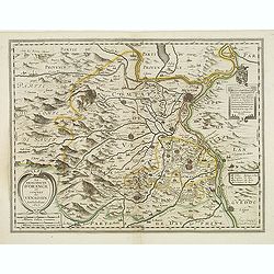
Patrimoine St Pierre et Florentin.
A rare map Centred on the province of Florence. Very decorative title cartouche on the lower left-hand corner.
Date: Paris 1638
Selling price: ????
Please login to see price!
Sold
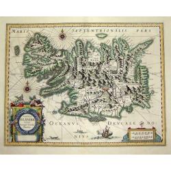
Tabula Islandiae
A fascinating and very beautiful map of Iceland from the Mercator / Hondius atlas based on the work of Juris Carolus. Carolus was a Dutch traveler who probably derived hi...
Date: Amsterdam, 1638
Selling price: ????
Please login to see price!
Sold
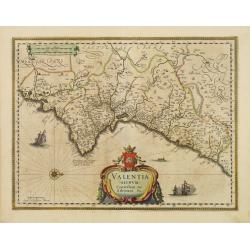
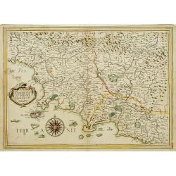
Valentia regnum Contestani, Ptol. Edentani, Plin.
Fine map of Valencia.
Date: Amsterdam 1638
Selling price: ????
Please login to see price!
Sold
Campus Inter Bohum et Borystenem.
A handsome map of the Dnieper River.
Date: Amsterdam 1638
Selling price: ????
Please login to see price!
Sold
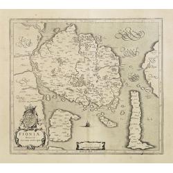
Fioniae nova et acurata descriptio.
Early map, including Odense and the island Langeland . Prepared by Gerard Mercator.
Date: Amsterdam, 1638
Selling price: ????
Please login to see price!
Sold
BOHEMIA.
Fine and early map of Czechoslovakia after Johann Criginger and used by Blaeu and others. Centered on Prag. With decorative title cartouche.From "le Théâtre du mon...
Date: Amsterdam, 1635-1638
Selling price: ????
Please login to see price!
Sold
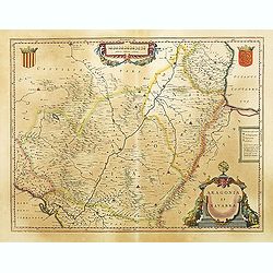
ARAGONIA ET NAVARRA.
A fine map of the Spanish provinces of Aragon and Navarre, centered on Saragossa and Pamplona. Towns, rivers, mountains, lakes and valleys are depicted.From \"le Th�...
Date: Amsterdam, 1635-1638
Selling price: ????
Please login to see price!
Sold in 2008
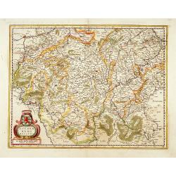
Argow cum parte merid. Zurichgow.
Including the towns of Lucerne, Bern and Züricher and Lucerner See.
Date: Amsterdam, 1638
Selling price: ????
Please login to see price!
Sold in 2009
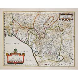
Stato della Republico di Lucca.
Hendrick Hondius (1597-1651). In association with Johannes Janssonius, Hendrick continued to publish the Mercator-Hondius Atlas, which was improved and enlarged, the by t...
Date: Amsterdam, 1638
Selling price: ????
Please login to see price!
Sold in 2015

Gothia.
Southern part of Sweden including Stockholm, Uppsala, Gothenburg, Malmö. But also Copenhagen and Oslo.
Date: Amsterdam, 1638
Selling price: ????
Please login to see price!
Sold in 2008
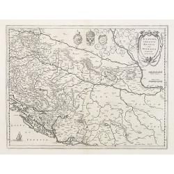
Sclavonia, Croatia cum Dalmatiae Parte.
Excellent map with coat-of-arms focusing specifically on the embattled nations of the former Yugoslavia.Latin text on verso.
Date: Amsterdam 1638
Selling price: ????
Please login to see price!
Sold
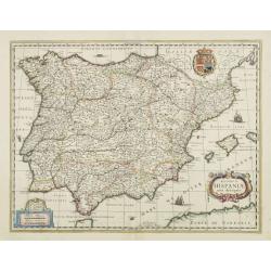
Regnorum Hispaniae nova descriptio.
A fine copy of this impressive map of the whole Iberian Peninsula. Decorated with the Spanish Royal Coat of Arms.
Date: Amsterdam, 1638
Selling price: ????
Please login to see price!
Sold
Comitatus Flandriae. . .
Map of Flanders prepared by Jodocus Hondius, the famous mapmaker. A beautiful ornamental title cartouche located on the lower left corner. Nicely ornate hand colored coat...
Date: Amsterdam, 1638
Selling price: ????
Please login to see price!
Sold in 2008
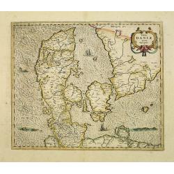
Totius Daniae nova descriptio.
Printed from the plate by Mercator.
Date: Amsterdam, 1638
Selling price: ????
Please login to see price!
Sold in 2008
Die Eydtgnoschafft Punten und Wallis Helvetia cum Confinijs
Detailed engraved map of entire Switzerland with Liechtenstein after Hans Conrad Geiger. With three cartouchs and 33 city coat of arms in the upper right corner. From \&q...
Date: Frankfurt, 1638
Selling price: ????
Please login to see price!
Sold in 2009
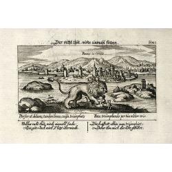
Parens, in Orient
Cooper engraved view of Porec in Croatia from D. Meisner "Sciographia Cosmica" printed 1638 in Nuremberg. With Latin and German aphorism.
Date: Nuremberg, 1638
Selling price: ????
Please login to see price!
Sold in 2009
Jutia Septentrionalis.
Early and detailed map of Jutland.Mercator was born in Rupelmonde in Flanders and studied in Louvain under Gemma Frisius, Dutch writer, astronomer and mathematician. The ...
Date: Amsterdam, 1638
Selling price: ????
Please login to see price!
Sold in 2018
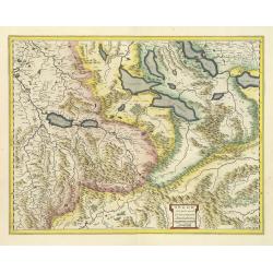
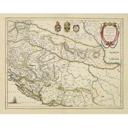
Karstia, Camiola, Histria et Windorum Marchia.
Including the Gulf of Trieste, Venise and the northern part of former Yugoslavia. Prepared by Gerard Mercator.
Date: Amsterdam, 1638
Selling price: ????
Please login to see price!
Sold
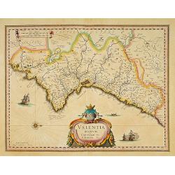
Valentia regnum Contestani, Ptol. Edentani, Plin.
Fine map of the Spanish province of Valencia, with large title cartouche and Dutch vessels offshore.
Date: Amsterdam, 1638
Selling price: ????
Please login to see price!
Sold in 2009
Campus Inter Bohum et Borystenem.
This map consist out of two parallel vertical strips depicting river Dnepr (BORYSTHENIS) from Cherkasy to Ochakiv, Black Sea. Originally prepared by Tomasz Makowski (1575...
Date: Amsterdam, 1638
Selling price: ????
Please login to see price!
Sold in 2009
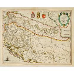
Sclavonia, Croatia cum Dalmatiae Parte.
Excellent map with coat-of-arms focusing specifically on the embattled nations of the former Yugoslavia. French text on verso.
Date: Amsterdam, 1638
Selling price: ????
Please login to see price!
Sold in 2015
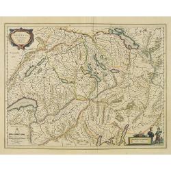
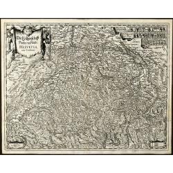
Helvetia cum finitimis regionibus confoederatis.
Detailed and finely engraved map of Switzerland.As Willem Blaeu died in 1638 most of his maps are actually published by his son Joan. This map carries his (engraved) sign...
Date: Amsterdam, 1638
Selling price: ????
Please login to see price!
Sold in 2010
![Zurichgow et Basiliensis Provincia [ Zurich].](/uploads/cache/28679-250x250.jpg)
Zurichgow et Basiliensis Provincia [ Zurich].
Finely engraved map including the towns of Basel, Lucerne, Zurich, etc.As Willem Blaeu died in 1638 most of his maps are actually published by his son Joan. This map was ...
Date: Amsterdam, 1638
Selling price: ????
Please login to see price!
Sold in 2018
Argow cum parte merid. Zurichgow.
Nice map of Canton Aargau and parts of the Cantons Schwyz, Zurich and Glarus. Includes the cities of Bern and Luzern.Based on the cartography of Gerard Mercator and very ...
Date: Amsterdam, 1638
Selling price: ????
Please login to see price!
Sold in 2012
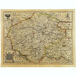
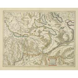
Das Wiflispurgergow.
Detailed map of Southwestern Switzerland after Gerhard Mercator's. With ornamental title cartouche and German text on the verso.It shows Geneva, Lake Geneva, Lake Neuchat...
Date: Amsterdam, 1638
Selling price: ????
Please login to see price!
Sold in 2010
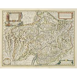
Alpinae seu Foederatae Rhaetiae subditarumque..
Detailed map Graubünden Canton in Switzerland. Including Chur, Davos, St.Moritz, etc. Engraved by Simon Hamersveldt.Originally engraved for Jodocus Hondius, at his death...
Date: Amsterdam, 1638
Selling price: ????
Please login to see price!
Sold in 2023
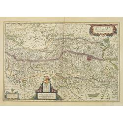
Austria Archiducatus.
Showing the Danube and its cities. Bordering Bohemia, Moravia, Saltsburg, Carinthia and Styria.Prepared by Wolfgang Lazio.As Willem Blaeu died in 1638 most of his maps ar...
Date: Amsterdam, 1638
Selling price: ????
Please login to see price!
Sold in 2010
Bohemia.
Fine and early map of Czechoslovakia after Johann Criginger and used by Blaeu and others.As Willem Blaeu died in 1638 most of his maps are actually published by his son J...
Date: Amsterdam, 1638
Selling price: ????
Please login to see price!
Sold in 2010
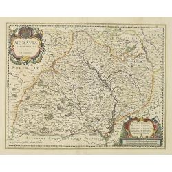
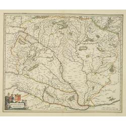
Moravia Marchionatus Auctore I.A. Comenio
Attractive map of the historic Moravia region of the Czech Republic roughly centered on the city of Olomouc (Olmutz). Finely engraved with mountains, forests and even the...
Date: Amsterdam, 1638
Selling price: ????
Please login to see price!
Sold in 2010
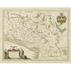
Silesia Ducatus..
Centered on Breslau.As Willem Blaeu died in 1638 most of his maps are actually published by his son Joan. This maps was actually published in volume II of a French editio...
Date: Amsterdam, 1638
Selling price: ????
Please login to see price!
Sold in 2010
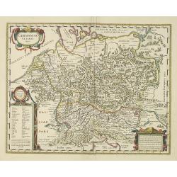
Germaniae veteris typus
A very attractive historical map of Germany was concepted after the map of Abraham Ortelius. It shows the area from the North Sea and Baltic Sea in the north to south of ...
Date: Amsterdam, 1638
Selling price: ????
Please login to see price!
Sold in 2016
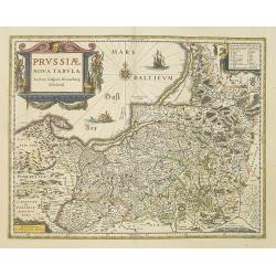
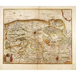
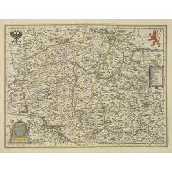
Prussiae nova tabula.
As indicated in the title cartouche, the map was prepared by the German cartographer Gaspar Henneberg of Erlich.As Willem Blaeu died in 1638 most of his maps are actually...
Date: Amsterdam, 1638
Selling price: ????
Please login to see price!
Sold in 2010
Magni Ducatus Lithuaniae.
This is the famous Radvilas (or Radziwill) map which occupies a very prominent position among works of European cartography from the end of the 16th and the beginning of ...
Date: Amsterdam, 1638
Selling price: ????
Please login to see price!
Sold in 2010
Campus Inter Bohum et Borystenem.
A handsome map of the Dnieper River.As Willem Blaeu died in 1638 most of his maps are actually published by his son Joan. This map carries his (engraved) signature and wa...
Date: Amsterdam, 1638
Selling price: ????
Please login to see price!
Sold in 2010
Tabula Russiae.
A re-issue, by Willem Blaeu, of Hessel Gerritsz' rare and influential map of Russia.This fine map was compiled from manuscripts brought back from Russia, by Isaac Massa t...
Date: Amsterdam, 1638
Selling price: ????
Please login to see price!
Sold in 2010
Transylvania Sibenburgen.
Crisply engraved chart of Transylvania, today parts of Hungary and Romania. Nice detail of forested areas, mountain ranges, rivers and towns.Beautifully colored cartouche...
Date: Amsterdam, 1638
Selling price: ????
Please login to see price!
Sold in 2010
Hungaria Regnum.
Detailed map of Hungary centered on Budapest. Including the towns of Vienna, Zagreb as well.As Willem Blaeu died in 1638 most of his maps are actually published by his so...
Date: Amsterdam, 1638
Selling price: ????
Please login to see price!
Sold in 2010
Sclavonia, Croatia cum Dalmatiae Parte.
Excellent map with coat-of-arms focusing specifically on the embattled nations of the former Yugoslavia. As Willem Blaeu died in 1638 most of his maps are actually publis...
Date: Amsterdam, 1638
Selling price: ????
Please login to see price!
Sold in 2023
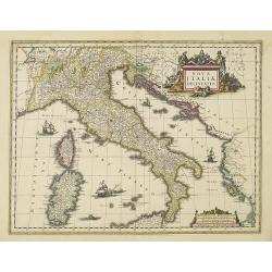
Nova Italiae delineatio.
Originally engraved for Jodocus Hondius II, at his death in August 1629 this map was, among other copper plates,purchased by Willem Blaeu who trimmed the figured borders,...
Date: Amsterdam, 1638
Selling price: ????
Please login to see price!
Sold in 2016
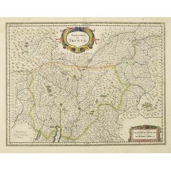
Territorio di Trento.
Centered at the town of Trento. In lower right part of Lake Garda.As Willem Blaeu died in 1638 most of his maps are actually published by his son Joan. This map carries h...
Date: Amsterdam, 1638
Selling price: ????
Please login to see price!
Sold in 2022
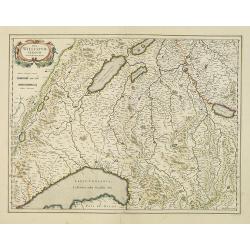
Pedemontana Regio cum Genvensium territorio et ..
Very fine map of Piermont. Including towns of Turin, Milan, Genoa, St.Remy, Monaco, Nice, etc. Large title cartouche lower right.As Willem Blaeu died in 1638 most of his ...
Date: Amsterdam, 1638
Selling price: ????
Please login to see price!
Sold in 2023
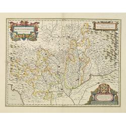
Montisferrati Ducatus.
Very fine map covering the source of the river Po, north of Milan, including town of Turin. Large dedicational cartouche to Jacob Backer.As Willem Blaeu died in 1638 most...
Date: Amsterdam, 1638
Selling price: ????
Please login to see price!
Sold in 2020
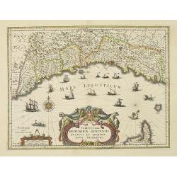
Serenissimae Reipublicae Genuensis Ducatus et Dominii..
Includes the coast of the Riviera from Nice to La Spezia. A most decorative map with impressive cartouche and extensive shipping. Engraved by Dirk Gryp. As Willem Blaeu d...
Date: Amsterdam, 1638
Selling price: ????
Please login to see price!
Sold
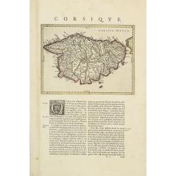
Corsica Insula.
Map of Corsica in copper engraving on a sheet with letterpress with French text description of the island.As Willem Blaeu died in 1638 most of his maps are actually publi...
Date: Amsterdam, 1638
Selling price: ????
Please login to see price!
Sold
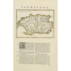
Sardinia Insula.
Map of Sardinia in copper engraving on a sheet with letterpress with French text description of the island.As Willem Blaeu died in 1638 most of his maps are actually publ...
Date: Amsterdam, 1638
Selling price: ????
Please login to see price!
Sold in 2010
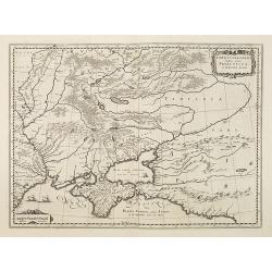
Taurica Chersonesus, Nostra aetate Przecopsca, et Gazara dicitur.
Part of Russia with in the north Smolensk and Moscow and in the south the Black Sea.
Date: Amsterdam, 1638
Selling price: ????
Please login to see price!
Sold in 2010
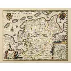
Typus Frisiae Orientalis. . .
Decorative map of east Friesland in Germany with the Watten islands. With inset map of the area south of Emden.Prepared by Ubbo Emmius (1547-1625).As Willem Blaeu died in...
Date: Amsterdam, 1638
Selling price: ????
Please login to see price!
Sold in 2010
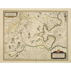
Oldenburg Comitatus.
Willem Blaeu's attractive map of Oldenburg, also depicting Bremen. As Willem Blaeu died in 1638 most of his maps are actually published by his son Joan. This maps carries...
Date: Amsterdam, 1638
Selling price: ????
Please login to see price!
Sold in 2016