Browse Listings in Europe
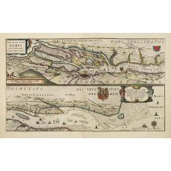
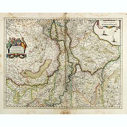
Celeberrimi Fluvis Albis nova delineatio.
Beautiful map of the river Elbe and Hamburg. French text on verso.Originally engraved for Jodocus Hondius, at his death on August 18, 1629, this among 39 other Hondius co...
Date: Amsterdam, 1638
Selling price: ????
Please login to see price!
Sold in 2013
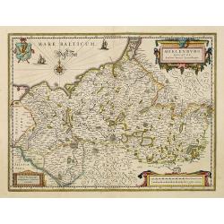
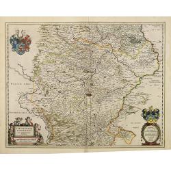
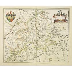
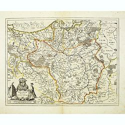
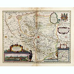
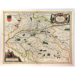
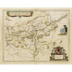
Meklenburg Ducatus.
Finely engraved map with a very decorative title cartouche adorned with a chain of fruits. A ship is sailing on the Baltic near a wind rose. In the left-hand upper part, ...
Date: Amsterdam, 1638
Selling price: ????
Please login to see price!
Sold in 2021
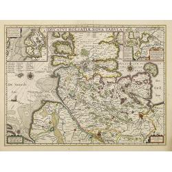
Ducatus Holsatiae nova tabula.
Finely engraved map centered on the area north of Hamburg and Lubeck with two insets.This is a second state of a map initially made by Jodocus Hondius.As Willem Blaeu die...
Date: Amsterdam, 1638
Selling price: ????
Please login to see price!
Sold in 2014
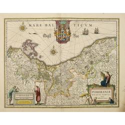
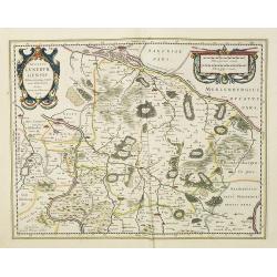
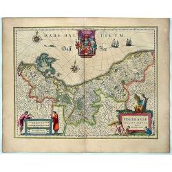
Pomeraniae Ducatus Tabula. Auctore Eilhardo Lubino.
Poland with eastern Germany.As Willem Blaeu died in 1638 most of his maps are actually published by his son Joan. This maps carries his (engraved) signature and was actua...
Date: Amsterdam, 1638
Selling price: ????
Please login to see price!
Sold in 2013
Brandeburgum Marchionatus. . .
Decorative map of part of Pomerania, Mecklenburg and Rugia with excellent detail of forests, rivers, towns and villages. Ornamented with two compass roses, cherubs and pu...
Date: Amsterdam, 1638
Selling price: ????
Please login to see price!
Sold in 2019
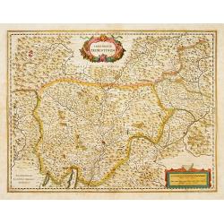
Thuringia landgraviatus.
Attractive map of Thüringen based on Adolar Erich's important map of 1625. Roughly centered on Erfurt, it extends to include Mansfield, Halle, Muhlhausen and Meiningen. ...
Date: Amsterdam, 1638
Selling price: ????
Please login to see price!
Sold in 2014
Episcopatus Hildesiensis descriptio novissima.
A fine and attractive mid-17th century folio sheet copper engraved map of the region around Hildesheim, in Lower Saxony. Includes numerous cities and corresponding coat o...
Date: Amsterdam, 1638
Selling price: ????
Please login to see price!
Sold in 2017
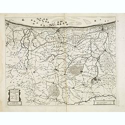
Ducatus Luneburgensis Adiacentiumque regionum delineatio. Auctore Johanne Mellingero.
A fine example of this map of Luneburg, extending from Hamburg to Wolfenbuttel, showing the lower Albis River. Bremen, Lunenborg, Nienborg, Brunswig, Magdenburg and Olden...
Date: Amsterdam, 1638
Selling price: ????
Please login to see price!
Sold in 2017

Paderbornensis Episscopatus Descriptio Nova.
Detailed map centered on Paderborn. Embellished with several coats of arms. Prepared by Joannes Michael Gigas (1580-1650+), a doctor, mathematician and geographer who mad...
Date: Amsterdam, 1638
Selling price: ????
Please login to see price!
Sold in 2017
Wirtenberg Ducatus.
Map depicting the area south of Heidelberg, including Stuttgart, Ulm, etc. and the river Danube.A beautiful coat of arms and a splendid title cartouche decorated by three...
Date: Amsterdam, 1638
Selling price: ????
Please login to see price!
Sold in 2010
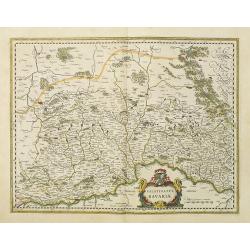
Bavaria Ducatus.
Map shows total Bavaria and prepared by Gerard Mercator. Blaeu is giving credit in the title.A beautiful coat of arms and a splendid title cartouche decorated with chain ...
Date: Amsterdam, 1638
Selling price: ????
Please login to see price!
Sold in 2010
Palatinatus Bavariae.
Map depicting the area south of Heidelberg, including Stuttgart, Ulm, etc.. and river Danube.A beautiful coat of arms and a splendid title cartouche decorated by three ch...
Date: Amsterdam, 1638
Selling price: ????
Please login to see price!
Sold in 2017
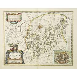
Territorium Norimbergense.
Centered on Nuremberg the capital of the printing shop of Homann. Lower right hand corner inset plan of Nuremberg, with a key to the major buildings. The large title cart...
Date: Amsterdam, 1638
Selling price: ????
Please login to see price!
Sold in 2018
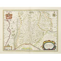
Erpach Comitatus.
Elegantly engraved map of the region including Heidelberg, centered on Eparch and showing part of the River Rhine and River Main with the towns of Gensheim, Worms, Milten...
Date: Amsterdam, 1638
Selling price: ????
Please login to see price!
Sold in 2017
Franconia Vulgo Franckenlandt.
Willem Blaeu's attractive map of Frankenland.As Willem Blaeu died in 1638 most of his maps are actually published by his son Joan. This maps carries his (engraved) signat...
Date: Amsterdam, 1638
Selling price: ????
Please login to see price!
Sold in 2010
Palatinatus ad Rhenum.
Covering southern part of the river Rhine. Including the towns of Frankfurt, Heidelberg, Nuremberg, Spier, etc. Upper right part, beautiful royal arms. Lower right, a sca...
Date: Amsterdam, 1638
Selling price: ????
Please login to see price!
Sold in 2018
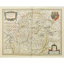
Nassovia Comitatus.
Elegantly engraved map of the region including Koblenz, Sigen and Dillenburg. The mountainous topography is graphically depicted and there is a coats of arms in the corne...
Date: Amsterdam, 1638
Selling price: ????
Please login to see price!
Sold in 2018
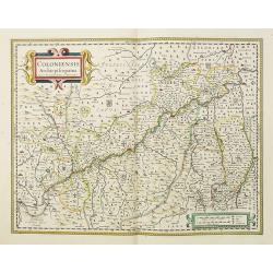
Coloniensis Archiepiscopatus. . .
Detailed map centered on the river Rhine and the city of Cologn, punctuated by several coats of arms.A beautiful coat of arms and a splendid title cartouche decorated by ...
Date: Amsterdam, 1638
Selling price: ????
Please login to see price!
Sold in 2018
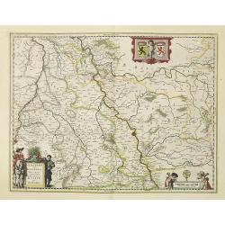
Iuliacensis et Montensis Ducatus.
Finely engraved map depicts the Duchies of Jülich and Berg on the Rhine River. It is richly embellished with cartouches, figures and coats of arms.As Willem Blaeu died i...
Date: Amsterdam, 1638
Selling price: ????
Please login to see price!
Sold in 2021
Comitatus Marchia et Ravensberg.
In the center of the map about the decorative cartouche is Hattington and Bochum. In the upper left is the confluence of the Weser and Lippe Rivers. In the lower left is ...
Date: Amsterdam, 1638
Selling price: ????
Please login to see price!
Sold in 2017
Clivia Ducatus et Ravestein Dominium.
A very decorative map showing the towns of Nijmegen, Venlo, Moers and Emmerich.As Willem Blaeu died in 1638 most of his maps are actually published by his son Joan. This ...
Date: Amsterdam, 1638
Selling price: ????
Please login to see price!
Sold in 2018
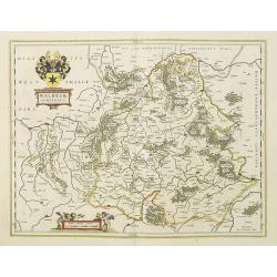
Waldeck Comitatus.
Map centered on Waldeck, Korbach, etc.As Willem Blaeu died in 1638 most of his maps are actually published by his son Joan. This maps carries his (engraved) signature and...
Date: Amsterdam, 1638
Selling price: ????
Please login to see price!
Sold in 2022
Territorium Abbatiae Heresfel-Densis.
A large seventeenth century hand colored map of the territory of Hirschfeld, (Hersfeld/Hesse) Germany. Shows Bad Hersfeld vicinity. As Willem Blaeu died in 1638 most of h...
Date: Amsterdam, 1638
Selling price: ????
Please login to see price!
Sold in 2017
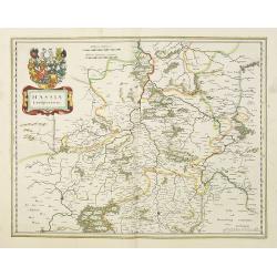
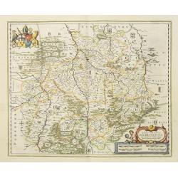
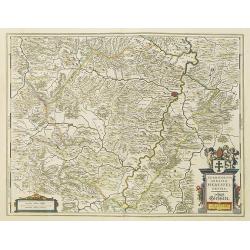
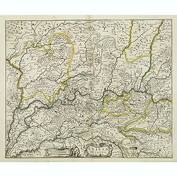
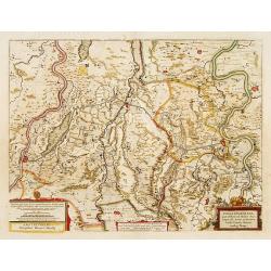
Hassia Landgraviatus.
Very detailed engraved map of Hesse by Willem and Joan Blaeu. With title cartouches and coat of arms. Showing the area between Alsfeld, Northeim and Eisenach. Centered on...
Date: Amsterdam 1638
Selling price: ????
Please login to see price!
Sold in 2017
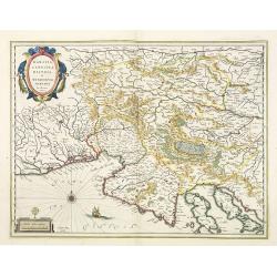
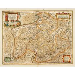
Karstia, Camiola, Histria et Windorum Marchia.
Including the Gulf of Trieste, Venice and the northern part of former Yugoslavia. Prepared by Gerard Mercator.With the signature of Willem Blaeu in lower left corner. As ...
Date: Amsterdam, 1638
Selling price: ????
Please login to see price!
Sold in 2023
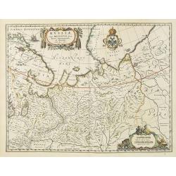
Russiae vulgo Moscovia dictae, partes, septentrionalis et orientalis.
This fine map was compiled from manuscripts brought back from Russia, by Isaac Massa. Covering the area from Finland to Siberia and beyond the Jenisej River and south to ...
Date: Amsterdam, 1638
Selling price: ????
Please login to see price!
Sold
Polonia regnum et Silesia ducatus.
Very decorative map of Poland embellished with two cartouches and two coats of arms surmounted by cherubs and female figures. Showing the region from the Oder east to Pod...
Date: Amsterdam, 1638
Selling price: ????
Please login to see price!
Sold in 2010
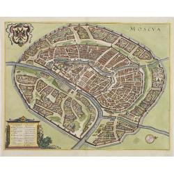
Moscua.
Town-plan of Moscow, with Moscua River, Iausa River, Neglina River, Kremlin, etc. With coat of arms upper left. Numbered and lettered key showing 17 places of interest.
Date: Frankfurt, 1638
Selling price: ????
Please login to see price!
Sold in 2011
Pomeraniae Ducatus Tabula. Amstelodami, Guiljelm Blaeuw excudit.
This attractive map shows all of the area of Pomerania, in present day eastern Germany and Poland with considerable detail. An elaborate coat of arms of Pomerania is at ...
Date: Amsterdam, (1630) 1635-1638
Selling price: ????
Please login to see price!
Sold in 2012
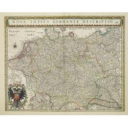
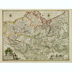
Nova Totius Germaniae Descriptio.
Map of Germany, Low Countries and Poland.As Willem Blaeu died in 1638 most of his maps are actually published by his son Joan. This maps carries his (engraved) signature ...
Date: Amsterdam, 1638
Selling price: ????
Please login to see price!
Sold in 2022
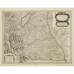
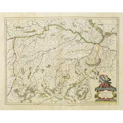
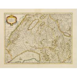
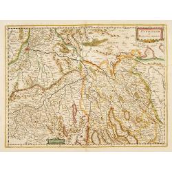
Alemannia sive Suevia Superior.
Detailed map of the Baden-Württemberg region filled with detailed information and a graphic depiction of the mountains to the east. With the Boden See in upper left corn...
Date: Amsterdam, 1638
Selling price: ????
Please login to see price!
Sold in 2022
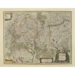
Sueviae nova tabula.
Map depicting the area south of Heidelberg, including Stuttgart, Ulm, etc.. and river Danube.A beautiful coat of arms and a splendid title cartouche decorated by three ch...
Date: Amsterdam, 1638
Selling price: ????
Please login to see price!
Sold in 2012
Comitatus Bentheim et Steinfurt.
French text on verso. An excellent and early map of Bentheim and Steinfurt in Germany. Very decorative title cartouche surrounded by two coats of arms. The scale cartouch...
Date: Amsterdam, 1638
Selling price: ????
Please login to see price!
Sold in 2014
Flandriae pars occidentalis.
Rare map of Flanders with the city of Dunkerque shown and a huge fleet of ships. The interior is well engraved with forests and towns. With nice cartouche with agricultur...
Date: Amsterdam, ca. 1638
Selling price: ????
Please login to see price!
Sold
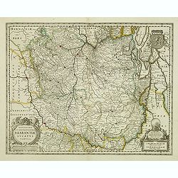
Novissima et Accuratissima Brabantiae Ducatus Tabula.
North is to the right. Like all other maps of Brabantiae Ducatus, it encloses the area between the rivers Rhine, Maas and Schelde, with Namur as the most southern town. O...
Date: Amsterdam, 1638
Selling price: ????
Please login to see price!
Sold in 2012
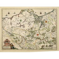
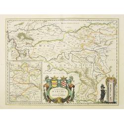
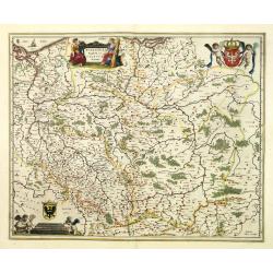
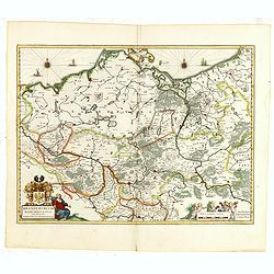
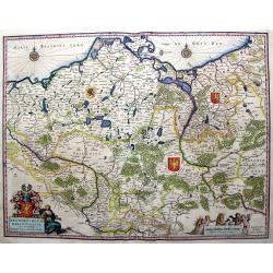
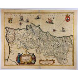
Brandeburgum Marchionatus cum Ducatibus Pomeraniæ et Mekelenburgi.
Decorative map of part of Pomerania, Mecklenburg, Rugia and part of present Poland with excellent detail of forests, rivers, towns and villages. Ornamented with two compa...
Date: Amsterdam, 1638
Selling price: ????
Please login to see price!
Sold in 2016
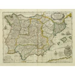
Typus Hispaniae ab Hesselo Gerardo delineata. . .
Decorative map of the kingdom of Spain and Portugal by Joan. Janssonius after the cartographic source by Hessel Gerard. Embellished by sailing ship, compass roses, and co...
Date: Amsterdam, 1638
Selling price: ????
Please login to see price!
Sold
Clivia Ducatus.
Detailed map of the area around Arnhem, Cleve, Wesel, Geldern, etc.Latin text on verso.
Date: Amsterdam, 1638
Selling price: ????
Please login to see price!
Sold in 2012
Poloniae Nova et Acurata Descriptio.
A good example of a scarce map of Poland extending from Stettin and Crossen to Cracow, to Lublin and Warsaw and north to the Baltic. Imposing figures support the title pi...
Date: Amsterdam, 1638
Selling price: ????
Please login to see price!
Sold in 2012
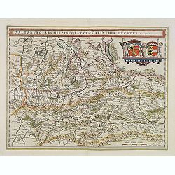
Saltzburg Archiepiscopatus, et Carinthia Ducatus.
Handsome map of the archbishopry of Salzburg and the Duchy of Carinthia.Title in banner form with two coats of arms and three cherubs decorating the map.As Willem Blaeu d...
Date: Amsterdam, 1638
Selling price: ????
Please login to see price!
Sold in 2013
Brandeburgum Marchionatus cum Ducatibus Pomeraniæ et Mekelenburgi.
Decorative map of part of Pomerania, Mecklenburg, Rugia and part of present Poland with excellent detail of forests, rivers, towns and villages. Ornamented with two compa...
Date: Amsterdam, 1638
Selling price: ????
Please login to see price!
Sold in 2015
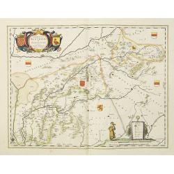
Geldria Ducatus et Zutphania Comitatus.
Map of Gelderland orientated west at the top, including Northern Limburg, eastern part of Brabant, Veluwe and Zutphen. Including the towns of Utrecht, Enschede, Rhunbeck,...
Date: Amsterdam, 1638
Selling price: ????
Please login to see price!
Sold in 2017
Osnabrugensis episcopatus.
A beautiful map of Munster centered on the city of Osnabruck. Prepared by Joannes Michael Gigas (1580-1650+), a doctor, mathematician and geographer. Showing an inset wit...
Date: Amsterdam, 1638
Selling price: ????
Please login to see price!
Sold in 2017
Tabula Bergarum ad Zoman Stenbergae.
A small section of the center has been rubbed: otherwise excellent. Rather rare to see an early road map in this time. It shows the city of Bergen op Zoom in Brabant.As W...
Date: Amsterdam, 1638
Selling price: ????
Please login to see price!
Sold in 2017
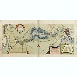
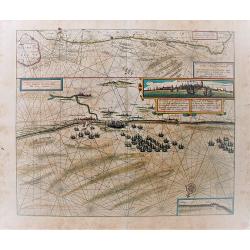
Tabula Castelli ad Sandflitam,..Bergas ad Zomam et Antverpi
East is at the top. The map pictures the complex military situation that had developed after the Dutch blockade of Antwerp. All entrenchment's and fortresses marked by a ...
Date: Amsterdam, 1638
Selling price: ????
Please login to see price!
Sold in 2017
Trevirensis Archiepiscopatus, et Lutzenburgi Ducatus.
Includes the region between Mass and Mosel. Title in decorative cartouche surrounded with coats of arms : Archbishopric of Trier and Duchy of Luxembourg.As Willem Blaeu d...
Date: Amsterdam, 1638
Selling price: ????
Please login to see price!
Sold in 2016
Brandeburgum Marchionatus cum Ducatibus Pomeraniae et Meklenburgi.
Very Decorative map of part of Pomerania, Mecklenburg, Rugia and part of present Poland with excellent detail of forests, rivers, towns and villages. Ornamented with two ...
Date: Amsterdam, 1638
Selling price: ????
Please login to see price!
Sold in 2016
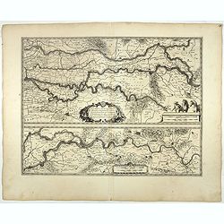
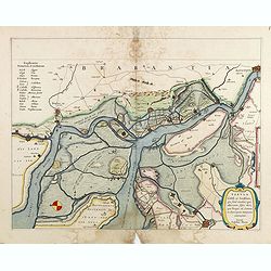
Tractus Rheni et Mosae totusq Vahalis.
Shows that part of the central Netherlands where the three great rivers flow to within but a few kilometers of each below Wesel. The scale allows most of the larger towns...
Date: Amsterdam, 1638
Selling price: ????
Please login to see price!
Sold in 2017
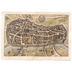
Reims en Champagne.
Striking birdseye view of Reims in Champagne, from Merian's “Neuwe Archontologica Cosmica”, published in 1638. It shows the detailed town plan of Reims and Champagne,...
Date: Frankfurt, 1638
Selling price: ????
Please login to see price!
Sold in 2018
![Magni Ducatus Lithuaniae. . . (together with] Campus Inter Bohum et Borystenem. . .](/uploads/cache/36645-250x250.jpg)
Magni Ducatus Lithuaniae. . . (together with] Campus Inter Bohum et Borystenem. . .
Six sheet wall map of Lithuania and parts of Poland, Russia, Ukraine, Latvia, etc., extending to Cracow, Kyiv, Warsaw, Riga, Konigsberg, Danzig, Leopolis, etc.This is the...
Date: Amsterdam, 1638
Selling price: ????
Please login to see price!
Sold in 2015
Ducatus Turonensis....
Lovely decorative map of the Touraine region of France with Tours and the Loire River at center. Two decorative cartouches feature allegorical renderings of Mother Earth ...
Date: Amsterdam, ca. 1638
Selling price: ????
Please login to see price!
Sold in 2018
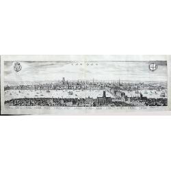
London
A panoramic, early view of London before the fire 1666, it has a key noting 43 places within the City. This large view extends from the King's Palace at Whitehall to the ...
Date: Frankfurt, 1638
Selling price: ????
Please login to see price!
Sold in 2016
![EVROPAM sive CELTICAM VETEREM sic describere conabar Abrahamus Ortelius. [CELTIC EUROPE]](/uploads/cache/37626-250x250.jpg)
EVROPAM sive CELTICAM VETEREM sic describere conabar Abrahamus Ortelius. [CELTIC EUROPE]
Possibly derived to some extent from Ortelius' own two sheet map of the Roman Empire, which appeared in 1571. Further, this map is based on classical sources, such as Sal...
Date: Amsterdam, 1638
Selling price: ????
Please login to see price!
Sold in 2017
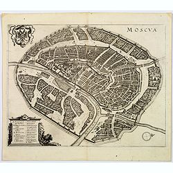
Moscua.
Striking birds-eye view of Moscow, from Merian's" Neuwe Archontologica Cosmica" . . ., published in 1638. With Moscow River, Iausa River, Neglina River, Kremlin...
Date: Frankfurt, 1638
Selling price: ????
Please login to see price!
Sold in 2017
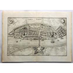
Campia Campen. (Kampen)
Striking view of Kampen on the Ysel River, with 2 coats of arms (one blank) and several sailing ships. Shows town plan, fortified walls, bridge, canals, etc. Matthäus ...
Date: Frankfurt, 1638
Selling price: ????
Please login to see price!
Sold in 2019
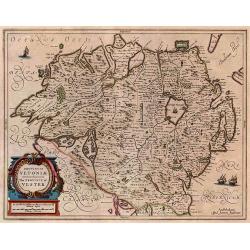
Provincia Ultoniae The Province of Ulster.
A finely engraved map of Ulster in northern Ireland. Adorned with vessels and a decorative title cartouche. Relief shown pictorially. Illustrated topography shows towns, ...
Date: Amsterdam, 1638
Selling price: ????
Please login to see price!
Sold in 2017
Pascaert vande Custe van Vlaenderen, van Walcheren tot Cales en Bouloigne in Vranckrijck.
A very decorative, large sea map, oriented south-westward. The upper part depicts the coastal region of Flanders, the lower part specifically the cost of Dünkirchen. Wit...
Date: Amsterdam, 1638
Selling price: ????
Please login to see price!
Sold in 2018
Portugallia et Algarbia quae olim Lusitania.
A striking map of Portugal with north oriented to the right. This lovely map by Jansson is adorned with numerous artistic embellishments including ships, coats-of-arms, t...
Date: Amsterdam, 1638
Selling price: ????
Please login to see price!
Sold in 2018
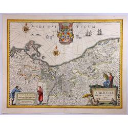
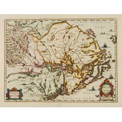
Pomeraniae Ducatus Tabula.
A detailed map of the Duchy of Pomerania, that between Poland and Germany. The map is highly decorated, including a title cartouche with five figures, fruit, a scale wit...
Date: Amsterdam, 1638
Selling price: ????
Please login to see price!
Sold in 2018
![Hafnia Metropolis et Portus Celeberrimus Daniae. [Coppenhagen]](/uploads/cache/82076-250x250.jpg)
Hafnia Metropolis et Portus Celeberrimus Daniae. [Coppenhagen]
A striking birds-eye view of Copenhagen, from Merian's Neuwe Archontologica Cosmica . . ., published in 1638. It shows town, buildings, churches, harbour, bridges, ships,...
Date: Frankfurt, 1638
Selling price: ????
Please login to see price!
Sold in 2018
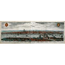
London.
A panoramic, early view of London before the fire of 1666, it has a key noting 43 places within the City. This large view extends from the King's Palace at Whitehall to ...
Date: Frankfurt a. M., 1638
Selling price: ????
Please login to see price!
Sold in 2019
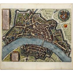
BASILEA Basel.
A decorative detailed plan of Basel, from Merian's "Neuwe Archontologica Cosmica", published in 1638. It shows the Rhine River, bridge, walled city, gates, stre...
Date: Frankfurt, 1638
Selling price: ????
Please login to see price!
Sold in 2020
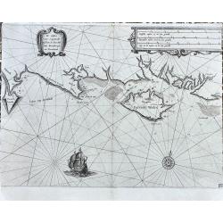
De Custen van Engelandt tuschen de droochte van Weembrugh en Poortlandt
Rare sea-chart from Blaeu's Zeespiegel. It shows the area around the Isle of Wight, from Weymouth and the Isle of Portland to Selsey and Chichester, including Poole, Sout...
Date: Amsterdam, ca. 1638
Selling price: ????
Please login to see price!
Sold in 2022
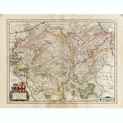
Das Wiflispurgergow.
In lower right Geneva and Lake Geneva with Lausanne. In center of map the cantons of Fribourg and Bern.
Date: Amsterdam, 1639
Selling price: ????
Please login to see price!
Sold in 2017
Alpinae seu Foederatae Rhaetiae subditarumque..
Detailed map Graubunden Canton in Switzerland. Including Chur, Davos, St.Moritz, etc. Engraved by Simon Hamersveldt.
Date: Amsterdam 1639
Selling price: ????
Please login to see price!
Sold
Fossa Eugeniana que a Rheno ad Mosam..
Detailed map of part of the country between rivers Rhine and Meuse showing a canal to be dug between 1626 and 1628 between Rheinberg in Germany and Venlo. A deficiency of...
Date: Amsterdam 1639
Selling price: ????
Please login to see price!
Sold
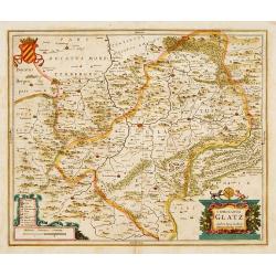
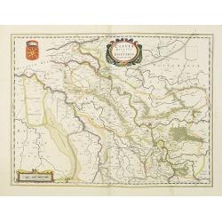
Comitatus Glatz.
Centered on Görlitz. The cartographer of this map was Bartholomeus Scultetus (1540-1614), active in Görlitz.. The title cartouche at bottom right shows ...
Date: Amsterdam 1639
Selling price: ????
Please login to see price!
Sold
Zurichgow et Basiliensis provincia.
Including the towns of Basle, Lucerne, Zürich, etc.
Date: Amsterdam, 1639
Selling price: ????
Please login to see price!
Sold in 2022
Belgii Veteris Typus ex conatibus..
Ancient map of present Netherlands, Belgium and Luxemburg. Engraved by Petrus Kaerius, after design of Abraham Ortelius. Fine title cartouche.
Date: Amsterdam 1639
Selling price: ????
Please login to see price!
Sold
Namurcum Comitatus.
Decorative map centred on Namen. With three very fine cartouches.
Date: Amsterdam, 1639
Selling price: ????
Please login to see price!
Sold in 2023
Belgii Veteris Typus ex conatibus..
Ancient map of present Netherlands, Belgium and Luxemburg. Engraved by Petrus Kaerius, after design of Abraham Ortelius. Fine title cartouche.
Date: Amsterdam 1639
Selling price: ????
Please login to see price!
Sold
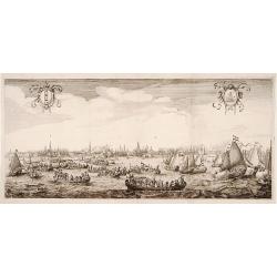
Queen Maria of France arriving at Amsterdam.
Panoramic view of the city from 't IJ. On the foreground extensive shipping being the arrival on August 31, 1638.The print was published in commemoration of Maria de 'Med...
Date: Amsterdam 1639
Selling price: ????
Please login to see price!
Sold
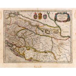
Sclavonia, Croatia, Bosnia cum Dalmatiae Parte.
Detailed and early map with coat-of-arms focusing specifically on the embattled nations of the former Yugoslavia. Signed lower left.
Date: Amsterdam, 1639
Selling price: ????
Please login to see price!
Sold in 2014
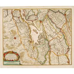
Rhinolandiae, Amstelandiae et ..
Centered on The Hague, Leiden, Haarlem, Amsterdam, Gouda, etc. West to the top. Prepared by Balthasar Floris van Berkenrode.
Date: Amsterdam, 1639
Selling price: ????
Please login to see price!
Sold
Territorium Tridentinum.
Detailed map centered on Trento. Showing the Dolomites mountains, northern tip of Lake Garda, Bolzano, etc.
Date: Amsterdam, 1639
Selling price: ????
Please login to see price!
Sold in 2013
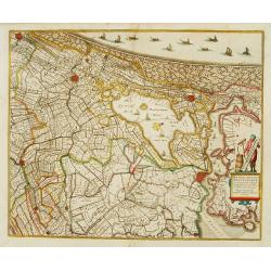
Novissima Tabula Insular Dordracensis. . .
The countship of Holland was subdivided into a number of bailiwicks. The most southerly bailiwick, bordering on Brabant was named Zuid-Holland. Many floods changed the ap...
Date: Amsterdam, 1639
Selling price: ????
Please login to see price!
Sold in 2021
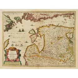
Nova Totius Livoniae accurata Descriptio.
Decorative map of Estonia and Latvia. Including the southern tip of Finland and the south eastern tip of Sweden, including Stockholm.
Date: Amsterdam 1639
Selling price: ????
Please login to see price!
Sold in 2009
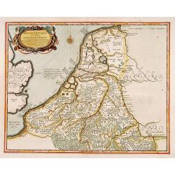
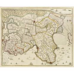
La Hollande Septentrionale.
Large map of the northern part of the province "Holland" in the Netherlands. The map comes from the "Atlas Novus" originally published by Janssonius i...
Date: Amsterdam, 1639
Selling price: ????
Please login to see price!
Sold in 2011
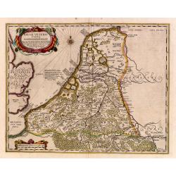
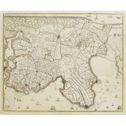
No title: Map of northern tip of Holland
The northern tip of Holland or West Friesland. West to the top. Including Amsterdam, Alkmaar, Hoorn, Enkhuizen, etc. Many ships in the Noord- and Zuiderzee.
Date: Amsterdam 1639
Selling price: ????
Please login to see price!
Sold
Uplandia.
Covers the area of the modern Uppsala, the vicinity of Stockholm, and includes most of Aland.
Date: Amsterdam, 1639
Selling price: ????
Please login to see price!
Sold in 2012