Browse Listings in East Meets West
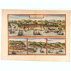
Calechut / Ormus / Canonor.
Four panoramic town-view on one sheet: the upper approximately two-thirds of this double page sheet contains a fine panoramic view of Calicut which is on the west coast o...
Date: Cologne, 1575
Selling price: ????
Please login to see price!
Sold in 2026
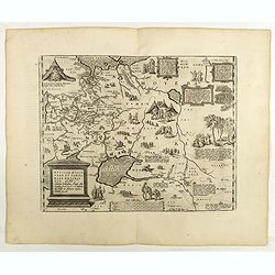
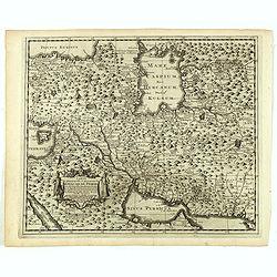
Russiae, Moscoviae et Tartariae Descriptio.
The map was engraved by Franz Hogenberg from an original by Anthony Jenkinson of the English Muscovy Company, drawn in 1562. Jenkinson traveled to Bukhara in 1557-59 and ...
Date: Antwerp, 1598
Selling price: ????
Please login to see price!
Sold in 2025
![[Portrait of J.H.van Linschoten.]](/uploads/cache/44878-250x250.jpg)
[Portrait of J.H.van Linschoten.]
Attractive roundel portrait of the famous Dutch navigator Jan Huijgen van Linschoten (1563-1610). The portrait is set within a strap work border incorporating vignettes o...
Date: Amsterdam, 1604
Selling price: ????
Please login to see price!
Sold in 2023
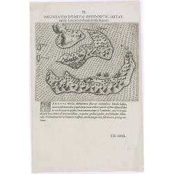
Delineatio Duorum Oppidorum, Ortat.
Early map of the Banda Islands.Theodore de Bry, a German engraver and book dealer, began a compilation of early voyages in 1590 and had published six parts at the time of...
Date: Frankfurt, 1609
Selling price: ????
Please login to see price!
Sold in 2025
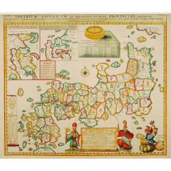
Imperium Japonicum in sexaginta et octo provincias divisum. Ex ipsorum Japonensium mappis & observationibus Kaempferianis. . .
The most important influence on European maps of Japan during the early years of the eighteenth century was that of E. Kaempfer based upon the manuscripts compiled during...
Date: The Hague, 1727
Selling price: ????
Please login to see price!
Sold in 2022
Carte la plus-nouvelle & plus-exacte du royaume de Perse avec ses côtes, villes maritimes, tous les pays qui en dependent, & ses lieux circonvoisins. . .
Detailed map of Persia with part of the Arabian Peninsular, Caspian Sea. The river Oxus is shown in present-day Uzbekistan. The region is labeled BUCHARESSEM, with the to...
Date: Leiden, 1729
Selling price: ????
Please login to see price!
Sold in 2025
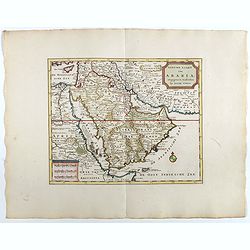
Nieuwe kaart van Arabia.
An attractive map of the Arabian Peninsula here is called Gelukkig Arabia or Happy Arabia . The map has a great advance on other maps of the time by showing the true exte...
Date: Amsterdam, 1740
Selling price: ????
Please login to see price!
Sold in 2025
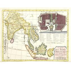
Carte des Indes orientales dressee sur les observations de l'Academie Royale des Sciences, et sur les memoires de la Compagnie des Indes.
Uncommon map of India with South East Asia, within the upper right corner inset "Plan de Pondicherry en 1741", with a key A-S, 1-21. Engraved by F.Desbruslins. ...
Date: Paris, Jean Desaint et Charles Saillant, 1744
Selling price: ????
Please login to see price!
Sold
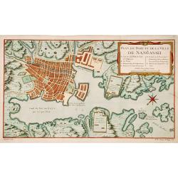
Plan du port et de la ville de Nangasaki.
This plan originates from Charlevoix's work Histoire et description Générele du Japon . His first in 1715 published work was the Histoire de l'etablissement du christia...
Date: Paris, 1760
Selling price: ????
Please login to see price!
Sold in 2023
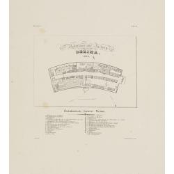
Nederlandsche Factory DEZIMA 1828.
Bird's-eye view of the manmade island of Deshima, a trading post of the V.O.C. from 1641 onward.Underneath the map a legend in Dutch and German with names of all the buil...
Date: Leiden, 1832-1852
Selling price: ????
Please login to see price!
Sold
