Browse Listings in Australia & Oceania > Australia
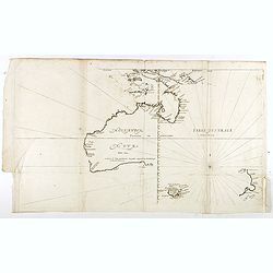
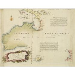
Hollandia Nova detecta 1644 , Terre Australe decouuerte l'an 1644.
Thevenot's map of Australia is the first published large-scale map of Australia and the first French map to record Tasman's 1642-1642 and 1644 discoveries in both Austral...
Date: Paris, Langlois, 1663
Selling price: ????
Please login to see price!
Sold in 2018
![[No title] Hollandia Nova detecta 1644.](/uploads/cache/36150-250x250.jpg)
[No title] Hollandia Nova detecta 1644.
EXTREMELY RARE FIRST EDITION of Thevenot's map of Australia which is the first published large-scale map of Australia and the first French map to record Tasman's 1642-42 ...
Date: Paris, 1664
Selling price: ????
Please login to see price!
Sold in 2015
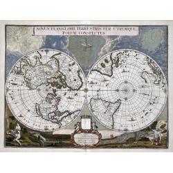
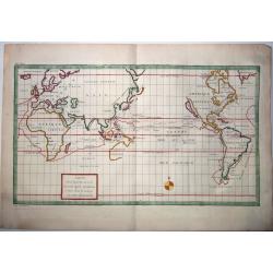
Novus Planiglobii Terrestris per Utrumque polum conspectus.
In the last years of his life, Joan Blaeu commissioned a double hemisphere world map, based on the unusual polar projection. Probably, the terrible fire of February 22, 1...
Date: Amsterdam, 1720
Selling price: ????
Please login to see price!
Sold in 2023
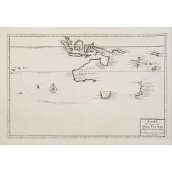
Kaart der Reyse van Abel Tasman volgens syn eygen opstel..
Rare and important map from Vol III, 2 of Valentyn's Oud en Nieuw Oost Indien [1726] detailing the discoveries of Abel Tasman in Australasia during the course of his two ...
Date: Amsterdam 1726
Selling price: ????
Please login to see price!
Sold
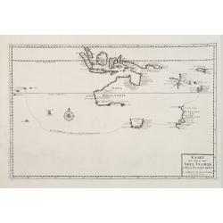
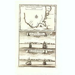
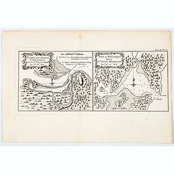
Anthony van Diemens Land / Het vaste Landt bezuyden den Klippigen hoek. / Het Staten Landt bezuyden den Klippigen hoek.
In the upper part, an early map of Tasmania (125x173mm.) shows the track of Abel Tasman's epic first voyage of 1642-1643, which resulted in the discovery of Tasmania and ...
Date: Amsterdam, 1726
Selling price: ????
Please login to see price!
Sold in 2015
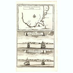
Anthony van Diemens Land / Het vaste Landt bezuyden den Klippigen hoek. / Het Staten Landt bezuyden den Klippigen hoek.
In the upper part, an early map of Tasmania (125x173mm.) shows the track of Abel Tasman's epic first voyage of 1642-1643, which resulted in the discovery of Tasmania and ...
Date: Amsterdam, 1726
Selling price: ????
Please login to see price!
Sold in 2016
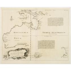
A Complete Map of the Southern Continent Survey'd by Capt. Abel Tasman & depicted by Order of the East Indian Cmpany in Holland In The Stadt House at Amsterdam.
The first large-scale English map devoted to Tasman's discoveries on both his voyages. Noted on the map are the promises of riches that are certain to be discovered by vi...
Date: London, 1744
Selling price: ????
Please login to see price!
Sold
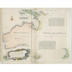
A Complete Map of the Southern Continent Survey'd by Capt. Abel Tasman & depicted by Order of the East Indian Company in Holland In The Stadt House at Amsterdam.
The first large-scale English map, one devoted to Tasman's discoveries on both his voyages. Noted on the map are the promises of riches that are certain to be discovered ...
Date: London, 1744
Selling price: ????
Please login to see price!
Sold in 2009
A Complete Map of the Southern Continent Survey'd by Capt. Abel Tasman & depicted by Order of the East Indian Cmpany in Holland In The Stadt House at Amsterdam.
The first large-scale English map devoted to Tasman's discoveries on both his voyages. Noted on the map are the promises of riches that are certain to be discovered by vi...
Date: London, 1744
Selling price: ????
Please login to see price!
Sold in 2010
Voyage around World by Anson. -CARTE dans lequelleon voit la route que le Centurion a tenu. . .
A map of Anson's voyage around the world from the French edition of the voyage published in 1750. It was engraved by Lattre and is identical to the English edition "...
Date: Paris, 1750
Selling price: ????
Please login to see price!
Sold in 2021
![Vue de la Riviere d'Endeavour sur la Cote de la Nouvelle Hollande ou le Vaisseau fut mis a la bande. [Tome IV Pl. 1ere.]](/uploads/cache/45540-250x250.jpg)
Vue de la Riviere d'Endeavour sur la Cote de la Nouvelle Hollande ou le Vaisseau fut mis a la bande. [Tome IV Pl. 1ere.]
The first known landscape drawing of the east coast of Australia. A View of the Endeavour River, on the coast of New Holland, where the ship was laid on shore, in order t...
Date: Paris, 1773
Selling price: ????
Please login to see price!
Sold in 2021
Entree de la Riviere Endeavour dans la Nle. Galles Meridle. . . / Baye de Botanique dans la Nle. Galles Meridionale. . .
Two maps of eastern of Australia, the entrance to the Endeavour River, and a map of Botany Bay, both in New South Wales, from the French edition of Cook, engraved by Robe...
Date: Paris, 1774
Selling price: ????
Please login to see price!
Sold in 2021
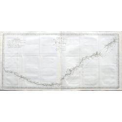
Carte de la Nle. Galles Merid.le ou de la Cote Orientale de la Nle. Hollande Découverte et visiteé par le Lieutenant J. Cook, Commandant de l'Endeavor. . .
One of Cook's most famous charts, the important first map of New South Wales, Australia. Oriented with north to the right side, and it extends from Point Hicks and Cape H...
Date: Paris, ca 1774
Selling price: ????
Please login to see price!
Sold in 2021
-250x250.JPG)
Carte d'une partie de la Mer du Sud Contenant les Découvertes des Vaisseaux de sa Majesté...
Complete title : "Carte d'une partie de la Mer du Sud Contenant les Découvertes des Vaisseaux de sa Majesté le Dauphin, Commodore Byron, La Tamar, Capit.ne Mouats,...
Date: 1774
Selling price: ????
Please login to see price!
Sold in 2022
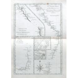
Nlle Galles Merid.le ou Côte Orientale de la Nouvelle Hollande. . .
R. Bonne's interesting sheet shows five charts of Captain Cook's and Tobias Furneaux discoveries on one sheet: Australias east coast in New South Wales, an inset with a p...
Date: Paris, ca 1787
Selling price: ????
Please login to see price!
Sold in 2021
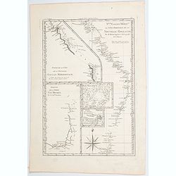
Nouvelle Galles Meridionale ou Cote Orientale de la Nouvelle Hollannde / Baie Botanique / Esquisse de la Terre Van-Diemen…
Rigobert Bonne's map of parts of southern and eastern Australia, based on earlier observations by Cook and Furneaux, published in Paris during the last quarter of the eig...
Date: Paris, 1787
Selling price: ????
Please login to see price!
Sold in 2023
-250x250.jpg)
A General Chart Exhibiting the Discoveries Made by Captn. James Cook in This and His Two Preceding Voyages; with the Tracks of the Ships Under His Command, by Lieutt. Robers of His Majesty's Royal Navy
This scarce, large map is based on Mercator's projection and was compiled by Lieut. Henry Roberts from Cook's surveys after the third expedition. The map, centered on Aus...
Date: London, ca. 1790
Selling price: ????
Please login to see price!
Sold in 2023
![Plan de la Baie Laplace . . . [with] Esquisse du Port Western (a la Terre Napoleon, Nle. Hollande) . . .[with] Plan des Iles Forestier (a la Nouvelle-Hollande). . . [with] Esquisse du Port Champagny (a la Terre Napoleon) . . .](/uploads/cache/44036-250x250.jpg)
Plan de la Baie Laplace . . . [with] Esquisse du Port Western (a la Terre Napoleon, Nle. Hollande) . . .[with] Plan des Iles Forestier (a la Nouvelle-Hollande). . . [with] Esquisse du Port Champagny (a la Terre Napoleon) . . .
Four maps showing Tumby Bay and Port Lincoln in South Australia, Western Port in Victoria and Forestier Islands in Western Australia, showing French discoveries prepared ...
Date: Paris, Langois, 1811
Selling price: ????
Please login to see price!
Sold in 2021
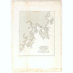
Carte générale de la Partie Sud-Est de la Terre de Diémen . . .
Important map of the south east coastline of Tasmania from South East Cape to Cape Bougainville includes the previous survey by Beautemps-Beaupre together with the later ...
Date: Paris, 1824
Selling price: ????
Please login to see price!
Sold in 2022
![Nouvelle-Hollande: Terre Napoleon. . . [plate V]](/uploads/cache/46268-250x250.jpg)
Nouvelle-Hollande: Terre Napoleon. . . [plate V]
A charming set of several views off the South Australian coast of Australia, after the original sketches by Lesueur, from Voyage de découvertes aux terres Australes by F...
Date: Paris, 1824
Selling price: ????
Please login to see price!
Sold in 2022
![Terre de Diemen. Navigation. [plate XIV].](/uploads/cache/46277-250x250.jpg)
Terre de Diemen. Navigation. [plate XIV].
Aboriginal boat, getting from island to island, or for gathering food, after the original sketches by Lesueur, from Voyage de découvertes aux terres Australes by Franço...
Date: Paris, 1824
Selling price: ????
Please login to see price!
Sold in 2023
![Nouvelle-Hollande - Y-Erran-Gou-La-Ga. [plate XIX]](/uploads/cache/46341-250x250.jpg)
Nouvelle-Hollande - Y-Erran-Gou-La-Ga. [plate XIX]
A portrait of a male Tasmanian Aboriginal Y-Erran-Gou-La-Ga by Lesueur, from Voyage de découvertes aux terres Australes by François Péron, 1824.The French expedition u...
Date: Paris, 1824
Selling price: ????
Please login to see price!
Sold in 2024
![Nouvelle-Hollande: Nelle Galles du sud - Norou-Gal-Derri s'avancant pour combattre. [plate XX]](/uploads/cache/46342-250x250.jpg)
Nouvelle-Hollande: Nelle Galles du sud - Norou-Gal-Derri s'avancant pour combattre. [plate XX]
A portrait of a male Tasmanian Aboriginal Norou-Gal-Derri by Lesueur, from Voyage de découvertes aux terres Australes by François Péron, 1824.The French expedition und...
Date: Paris, 1824
Selling price: ????
Please login to see price!
Sold in 2024
![Nouvelle-Hollande: Ile Bernier. - Kanguroo a Bandes [plate XXVII]](/uploads/cache/46349-250x250.jpg)
Nouvelle-Hollande: Ile Bernier. - Kanguroo a Bandes [plate XXVII]
Plate illustrating Kanguroo a Bandes by Lesueur, from Voyage de découvertes aux terres Australes by François Péron, 1824.The French expedition under Nicolas Baudin, wa...
Date: Paris, 1824
Selling price: ????
Please login to see price!
Sold in 2024
![Nouvelle-Hollande: Nouvelle Galles du sud. -Dasyure à longue queue. [plate XXXIII]](/uploads/cache/46355-250x250.jpg)
Nouvelle-Hollande: Nouvelle Galles du sud. -Dasyure à longue queue. [plate XXXIII]
Plate illustrating the Dasyure, who lives in Tasmania and south-eastern Australia. Plate by Lesueur, from Voyage de découvertes aux terres Australes by François Péron,...
Date: Paris, 1824
Selling price: ????
Please login to see price!
Sold in 2024
![Plan de la Baie Laplace [with] Esquisse du Port Western [with] Plan des Iles Forestier [with] Esquisse du Port Champagny.](/uploads/cache/46372-250x250.jpg)
Plan de la Baie Laplace [with] Esquisse du Port Western [with] Plan des Iles Forestier [with] Esquisse du Port Champagny.
Four maps on one sheet, Laplace Bay, Western Harbour, Forestier islands and Champagny Harbour, from Voyage de découvertes aux terres Australes by François Péron, 1824....
Date: Paris, 1824
Selling price: ????
Please login to see price!
Sold in 2025
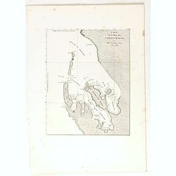
Carte de la Baie des Chiens-Marins. (Shark's Bay)
Map of a portion of the coastline of Western Australia, the Baie des Chiens-Marins, from Voyage de découvertes aux terres Australes by François Péron, 1824. The French...
Date: Paris, 1824
Selling price: ????
Please login to see price!
Sold in 2022
![Terre de Diemen. Arra-Maida. [plate XII]](/uploads/cache/46275-250x250.jpg)
Terre de Diemen. Arra-Maida. [plate XII]
A portrait of a female Tasmanian Aboriginal Arra-Maida, after the original sketches by Lesueur, from Voyage de découvertes aux terres Australes by François Péron, 1824...
Date: Paris, 1824
Selling price: ????
Please login to see price!
Sold in 2024
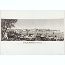
Nouvelle Hollande, Nouvelle Galles Du Sud, Vue De La Partie Meridion De La Ville De Sydney capitale Des Colonies Anglaise...
Early view of the southern part of the town of Sydney.After the original sketches by Lesueur, from Voyage de découvertes aux terres Australes by François Péron, 1824.T...
Date: Paris, 1824
Selling price: ????
Please login to see price!
Sold in 2021
![Terre de Diemen. Paraberi. [plate XI]](/uploads/cache/46274-250x250.jpg)
Terre de Diemen. Paraberi. [plate XI]
A portrait of the Tasmanian Aboriginal Paraberi, after the original sketches by Lesueur, from Voyage de découvertes aux terres Australes by François Péron, 1824.The Fr...
Date: Paris, 1824
Selling price: ????
Please login to see price!
Sold in 2024
![Nouvelle-Hollande. . . [plate VII]](/uploads/cache/40092-250x250.jpg)
Nouvelle-Hollande. . . [plate VII]
A charming set of five coastal views on the western and northern coast of Australia, after the original sketches by Lesueur, from Voyage de découvertes aux terres Austra...
Date: Paris, 1824
Selling price: ????
Please login to see price!
Sold in 2023
![Nouvelle-Hollande: Terre Napoleon. . . [plate V]](/uploads/cache/40095-250x250.jpg)
Nouvelle-Hollande: Terre Napoleon. . . [plate V]
A charming set of several views off the South Australian coast of Australia, after the original sketches by Lesueur, from Voyage de découvertes aux terres Australes by F...
Date: Paris, 1824
Selling price: ????
Please login to see price!
Sold in 2023
![Terre de Diemen. Navigation. [plate XIV]](/uploads/cache/40103-250x250.jpg)
Terre de Diemen. Navigation. [plate XIV]
Aboriginal boat, getting from island to island, or for gathering food, after the original sketches by Lesueur, from Voyage de découvertes aux terres Australes by Franço...
Date: Paris, 1824
Selling price: ????
Please login to see price!
Sold in 2022
![Nouvelle-Hollande. Terre d'Endracht. Cabanes des Naturels de la presqu' Ile Peron. [plate XXIV]](/uploads/cache/40113-250x250.jpg)
Nouvelle-Hollande. Terre d'Endracht. Cabanes des Naturels de la presqu' Ile Peron. [plate XXIV]
Aboriginal dwellings in the Northern Territory.After the original sketches by Lesueur, from Voyage de découvertes aux terres Australes by François Péron, 1824.The Fren...
Date: Paris, 1824
Selling price: ????
Please login to see price!
Sold in 2022
![Nouvelle-Hollande: Ile King. L'Elephant-Marin ou Phoque a Trompe. [plate XXXII]](/uploads/cache/40118-250x250.jpg)
Nouvelle-Hollande: Ile King. L'Elephant-Marin ou Phoque a Trompe. [plate XXXII]
Sea Lions lying on a beach on King Island off the South Australian coast, after the original sketches by Lesueur, from Voyage de découvertes aux terres Australes by Fran...
Date: Paris, 1824
Selling price: ????
Please login to see price!
Sold in 2021
![Nouvelle-Hollande: Ile Decres. Details du Casoar. [plate XLI]](/uploads/cache/40125-250x250.jpg)
Nouvelle-Hollande: Ile Decres. Details du Casoar. [plate XLI]
Details of the Australian flightless bird, the Cassowary. Details include, head and beak, tail feathers, plumes, claw etc. From Voyage de découvertes aux terres Australe...
Date: Paris, 1824
Selling price: ????
Please login to see price!
Sold in 2023
![Nouvelle-Hollande. . .[plate VII]](/uploads/cache/46270-250x250.jpg)
Nouvelle-Hollande. . .[plate VII]
A charming set of five coastal views on the western and northern coast of Australia, after the original sketches by Lesueur, from Voyage de découvertes aux terres Austra...
Date: Paris, 1824
Selling price: ????
Please login to see price!
Sold in 2022
![Terre de Diemen. Bara-Ourou. [plate VIII]](/uploads/cache/46271-250x250.jpg)
Terre de Diemen. Bara-Ourou. [plate VIII]
A portrait of the Tasmanian Aboriginal Bara-Ourou, after the original sketches by Lesueur, from Voyage de découvertes aux terres Australes by François Péron, 1824.The ...
Date: Paris, 1824
Selling price: ????
Please login to see price!
Sold in 2024
![Terre de Diemen. Grou-Agara. [plate X]](/uploads/cache/46273-250x250.jpg)
Terre de Diemen. Grou-Agara. [plate X]
A portrait of the Tasmanian Aboriginal Grou-Agara, after the original sketches by Lesueur, from Voyage de découvertes aux terres Australes by François Péron, 1824.The ...
Date: Paris, 1824
Selling price: ????
Please login to see price!
Sold in 2024
![Terre de Diemen. Ourlaga. [plate IX]](/uploads/cache/46272-250x250.jpg)
Terre de Diemen. Ourlaga. [plate IX]
A portrait of the female Tasmanian Aboriginal Ourlaga, after the original sketches by Lesueur, from Voyage de découvertes aux terres Australes by François Péron, 1824....
Date: Paris, 1824
Selling price: ????
Please login to see price!
Sold in 2024
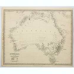
Australia.
An uncolored map of the continent of Australia in 1839, but published a year later in 1840, from the S.D.U.K. publication in London. The map identifies the years and name...
Date: London, 1840
Selling price: ????
Please login to see price!
Sold in 2023
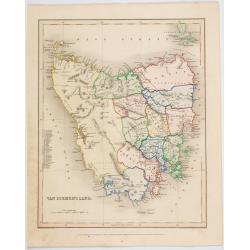
Van Diemen's Land.
A map of Van Diemen's Land (Tasmania) beautifully drawn and engraved by Joshua Archer in London for Grattan & Gilbert's "Modern Atlas".A small numbered tabl...
Date: London, 1840
Selling price: ????
Please login to see price!
Sold in 2023
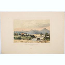
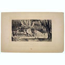
Riviere Derwent pres de Richemont.
An attractive hand colored lithograph showing the River Derwent at Richmond, which lies about 25 kms north-east of Hobart in Tasmania. The lithograph depicts a beautiful,...
Date: Paris, ca 1840
Selling price: ????
Please login to see price!
Sold in 2023
Monuments Funeraires de L'Ile Toud.
An unusual lithograph of funerial monuments connected with the island of Toud, in the Torres Strait, to the north of Queensland. Plate 189 taken from the 'Voyage au Pole ...
Date: Paris, 1842
Selling price: ????
Please login to see price!
Sold in 2023
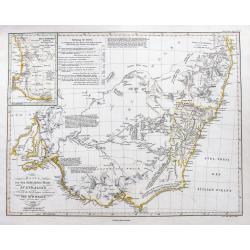
Karte von dem Südöstlichen Theile Australia's zur Übersicht der Entdeckungen im Innern von Neu Süd Wales bis zum Jahre 1832.
A fine map of South East Australia including Adelaide, Melbourne, Brisbane, and Sydney. With very interesting details of the interior, including short descriptions and no...
Date: Gotha, ca 1850
Selling price: ????
Please login to see price!
Sold in 2021
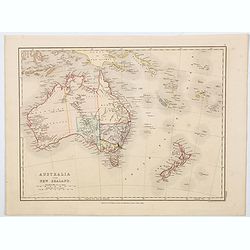
Australia and New Zealand.
A lovely map of Australia and New Zealand rendered in original soft pastel colours, published by E.P. Williams in London & Eton College. It is to be supposed that thi...
Date: London, ca 1850
Selling price: ????
Please login to see price!
Sold in 2023

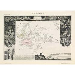
Océanie.
A very decorative 19th century map of the Pacific Ocean, with hand colored lines indicating the extent of Polynesia, Mirconesia, Melanesia, and Malaysia (or Southeast Asi...
Date: Paris, 1850
Selling price: ????
Please login to see price!
Sold in 2025
Océanie.
A very decorative 19th-century map of the Pacific Ocean, with hand-colored lines indicating the extent of Polynesia, Micronesia, Melanesia, and Malaysia (or Southeast Asi...
Date: Paris, 1850
Selling price: ????
Please login to see price!
Sold in 2022
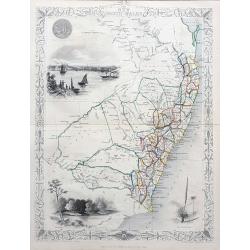
New South Wales
Very decorative and important map of NSW with Sydney, extending north until todays Brisbane and Gold Coast area. Shows many place names, and also with good inland detail!...
Date: London & New York, c1851
Selling price: ????
Please login to see price!
Sold in 2021

Australia.
Decorative steel engraved map of Australia, surrounded by illustrations of Sydney harbor, birds, kangaroos and local people. Interlocking border design. Taken from "...
Date: London, ca. 1851
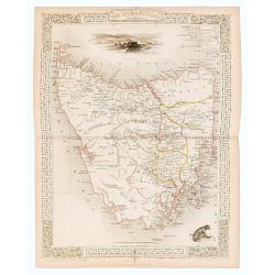
Van Diemen's Island or Tasmania.
Original steel engraved map of Tasmania. Three vignettes including one of Hobart Town. Decorative scrolling and title cartouche to the edges of the image. (Map 22 x 29.5 ...
Date: London / New York: J. / F. Tallis, 1856
Selling price: ????
Please login to see price!
Sold in 2023
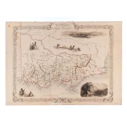
Victoria or Port Phillip.
24.5 x 32.5 cm. Original outline color. Steel engraved map. Five vignette illustrations including Melbourne. Decorative scrolling and title cartouche to the edges of the ...
Date: London & New York: John Tallis & Company, 1856
Selling price: ????
Please login to see price!
Sold in 2023
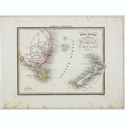
La Nuova Galles del Sud (Australia sud-est) La Diemenia e La Nuova Zelanda (Polinesia).
Uncommon map of the East Coast of Australia and New Zealand, prepared by Francesco Costantino Marmocchi. Above the map "Geografia Commerciale". From "Il G...
Date: Genova, Paolo Rivara fu Giacomo, 1858
Selling price: ????
Please login to see price!
Sold in 2026
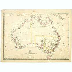
Australia.
Map of Australia by Edward Weller. With a reasonable amount of coastal detail, however, the interior is unsurprisingly bare of any information. No Queensland. 'Northern A...
Date: London, Day and Son, 1865
Selling price: ????
Please login to see price!
Sold in 2023
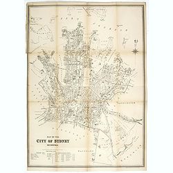
Map of the city of Sydney. New South Wales.
Early street plan of the city of Sydney, showing parishes, municipalities, buildings, public parks and recreation reserves. Lithographed and published by the dept of Land...
Date: Sydney, 1895
Selling price: ????
Please login to see price!
Sold in 2025
