Browse Listings in Asia > Tartary / Siberia
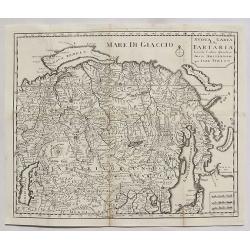
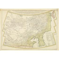
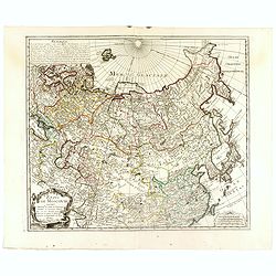
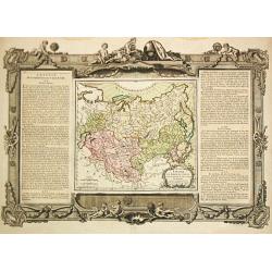
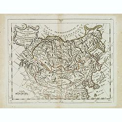
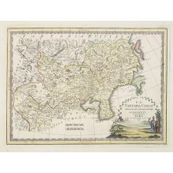
Nuova Carta della Tartaria.
A detailed map of Tartaria, extending from the Caspian Sea to Japan, Korea, Kamtchatka and the Pacific by Tirion in 1738.Isaak Tirion (1705–1765) was an 18th-century publ...
Date: Amsterdam, 1738
Selling price: ????
Please login to see price!
Sold in 2020
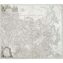
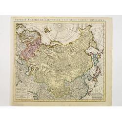
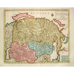
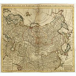
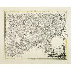
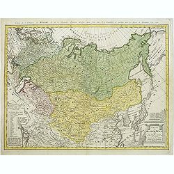
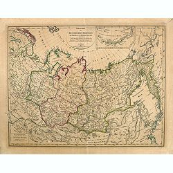
Imperii Russici et Tartariae Universae tam majoris Afiaticæ quam minoris et EuropæTabula.
Decorative map covering Russia, Tibet, China, Tartary, Korea, Taiwan and Japan prepared by J. M. Hasius. With a hefty landmass north of Honshu touching the Asian continen...
Date: Nuremberg, 1739
Selling price: ????
Please login to see price!
Sold in 2013
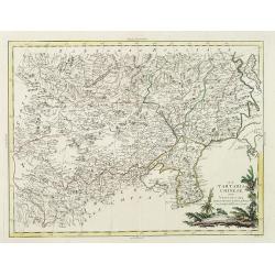
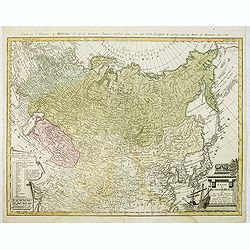
Imperii Russici et Tartariae Universae tam majoris Afiaticæ quam minoris et EuropæTabula.
The map is of interest for the use of East Sea, the sea between Korea and Japan, here called "Mere Orientale Minus".Decorative map covering Russia, Tibet, China...
Date: Nuremberg, 1739
Selling price: ????
Please login to see price!
Sold in 2012
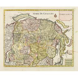
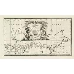
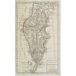
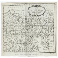
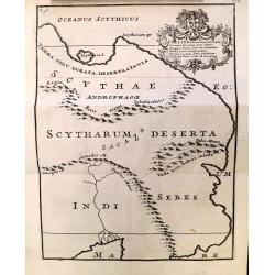
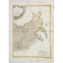
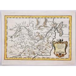
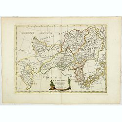
Tartaria.
A fine map of Siberia, including Korea and Japan. From "Atlante Novissimo Che Contiene Tutte Le Parti Del Mondo...." This atlas was published in Venice and was ...
Date: Venice, 1740
Selling price: ????
Please login to see price!
Sold in 2012
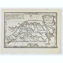
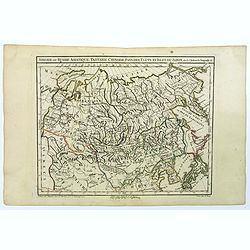
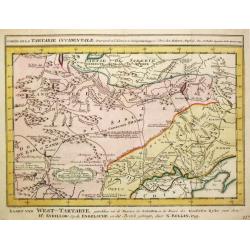
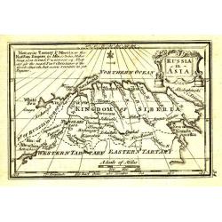
A General Map of Eastern and Western Tatary, commonly call'd Tartray, drawn from the Particular Maps of the Jesuit Missionaries. . .
Important map covering the region from the Gobi Desert to the coast, and including Korea. Including the Great Wall. The Korean peninsula is a bit distorted, and covered w...
Date: London, T.Gardner, 1738-1741
Selling price: ????
Please login to see price!
Sold in 2010
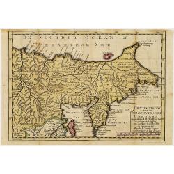
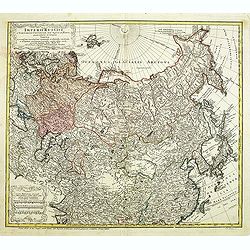
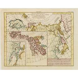
Het oosterdeel van de Moscoviesche Tarters. . .
Uncommon map of Russia and representing Siberia and including Kamchatka. This map is credited to Johann Matthias Haas (1684-1742) and Guillaume De l'Isle.
Date: Deventer, Almelo, 1742
Selling price: ????
Please login to see price!
Sold in 2012
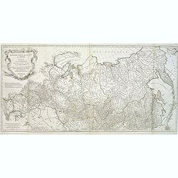
Kaert van Het geheele Russische Keizerryk..
Map of the whole Russian empire. Together with Major and Minor Tartary now enlarged with new discoveries in the year 1739 by captain Span(g)berg.Map extends from Scandina...
Date: Utrecht 1743
Selling price: ????
Please login to see price!
Sold
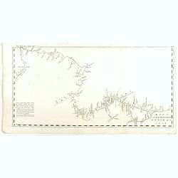
An exact chart of the countries through which Capt. Behring travelled from Tobolsky capital of Siberia ti the country of Kamtschatka.
The earliest English language map to show Vitus Behring's Route.After retiring from a tour as Captain in the Czar's Navy, Behring, originally from Denmark, settled in Vyb...
Date: London, 1744
Selling price: ????
Please login to see price!
Sold in 2013
Etats de Moscovie. . .
Fine and rare map of Russia, Siberia, China, Korea and Japan. George Louis Le Rouge was active between 1740 and 1780, in Paris at, rue des Augustins as a publisher, and w...
Date: Paris, 1744
Selling price: ????
Please login to see price!
Sold in 2023
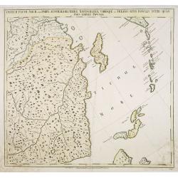
Ostium Fluvii Amur cum parte australiori terrae Kamtschatkae variisque in Oceano sitis Insulis inter quas pars eminet Japoniae. No.19
Detailed map of part of Siberia in Russia, including in the lower right part the Northern tip of Hokkaido and in the upper right corner the southern tip of Kamchatka. The...
Date: Petersburg, 1745
Selling price: ????
Please login to see price!
Sold in 2009
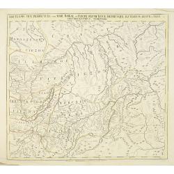
Territorii Iacutensis pars orientalior cum maxima parte terrae Kamtschatkae.
Detailed map of part of Siberia, including Kamtschatka. In the upper right corner an inset map 115x130mm of Siberia. The map was prepared by Joseph Nicolas De L'Isle and ...
Date: Petersburg, 1745
Selling price: ????
Please login to see price!
Sold in 2010
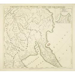
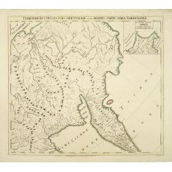
Irkutensis vice praefectura cum Mari Baikal, et fonte Fluvü Lenae, partibusque Fluviorum Argun et Amur. N. 17.
Detailed map of part of Siberia, including Baikal lake and Irkuck. The map was prepared by Joseph Nicolas De L'Isle and was included in "Atlas Russicus". The Ru...
Date: Petersburg, 1745
Selling price: ????
Please login to see price!
Sold in 2010
Territorii Iacutensis pars orientalior cum maxima parte terrae Kamtschatkae.
Detailed map of part of Siberia, including Kamtschatka. In the upper right corner an inset map 115x130mm of Siberia. The map was prepared by Joseph Nicolas De L’Isle and ...
Date: Petersburg, 1745
Selling price: ????
Please login to see price!
Sold in 2010
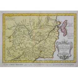
Carte de Tartarie Dressée sur les Relations de plusieurs Voyageurs. . .
Detailed copper-engraved map representing Tartary, with decorative title cartouche. Shows today's territory of Russia including Siberia, North China, Korea. With sub titl...
Date: Amsterdam, c. 1745
Selling price: ????
Please login to see price!
Sold
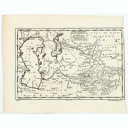
A Map of Karazm, Great Bukharia and Turkestan. . .
A pleasant little map of central Asia by Thomas Kitchin for Astley's "A New General Collection of Voyages and Travels. "Covers from the Caspian Sea across to th...
Date: London, 1745
Selling price: ????
Please login to see price!
Sold in 2019
A New and Accurate Map of the Whole Russian Empire as contained both in Europe and Asia. . .
Detailed map of Russia, from the Sea of Anadyr, Sea of Kamchatka and the Kuril Islands to Poland. In the NW Coast of America references to Tschirikov's contact with Alask...
Date: London, c. 1747
Selling price: ????
Please login to see price!
Sold in 2013
![A Map of Little Bochara, and the Adjacent Countrys... [and] The Empire of Hya (including grear part of Tangul)...](/uploads/cache/38612-250x250.jpg)
A Map of Little Bochara, and the Adjacent Countrys... [and] The Empire of Hya (including grear part of Tangul)...
A pair of uncommon maps of the Gobi Desert and Bochara region.Engraved by Thomas Kitchin - with his signature in lower bottom.From Astley, Thomas, "A New General Col...
Date: London, 1745-1747
Selling price: ????
Please login to see price!
Sold in 2016
A Map of Little Bochara, and the Adjacent Countrys...
Uncommon map of the Bochara region.Engraved by Thomas Kitchin - with his signature in the lower bottom.From Astley, Thomas, "A New General Collections of Voyages and...
Date: London, 1745-1747
Selling price: ????
Please login to see price!
Sold in 2017
![A Map of Little Bokhara, and the Adjacent Countrys... [and] The Empire of Hya (including grear part of Tangul)... [2 maps]](/uploads/cache/40038-250x250.jpg)
A Map of Little Bokhara, and the Adjacent Countrys... [and] The Empire of Hya (including grear part of Tangul)... [2 maps]
A pair of uncommon maps of the Gobi Desert and Bochara region of Central Asia and Western China.Engraved by Thomas Kitchin. From Astley's, "A New General Collections...
Date: London, 1745-1747
Selling price: ????
Please login to see price!
Sold in 2019
Carte de la Tartarie Orientale Pour Servir a L'Histoire Generale des Voyages.
Detailed map of Manchuria and the Northeast portion of Tartaria, including Sagallan Anga Hata. Produced by Nichlas Bellin for Prevost d'Exiles' “L'Histoire Generale des ...
Date: Paris, 1749
Selling price: ????
Please login to see price!
Sold in 2019
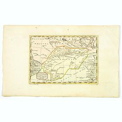
Nieuwe Kaart van Tartarie
Izaak Tirion (d. 1769) Amsterdam publisher. His ' Nieuwe en beknopte handatlas' saw 6 editions between before 1740 and after 1784. Also ' Tegenwoordige staat van alle vol...
Date: Amsterdam, c. 1750
Selling price: ????
Please login to see price!
Sold
Partie Orientale de l'Empire de Russie en Asie . . . la Tartarie Chinoise . . .
Map of the Asian part of the Russian Empire and the Tartary region, including Sakhalin and Kamchatka..Tartary was a name used by Europeans from the Middle Ages until the ...
Date: Paris, 1750
Selling price: ????
Please login to see price!
Sold in 2013
Kaert van Het geheele Russische Keizerryk...
Map of the whole Russian empire. Together with Major and Minor Tartary now enlarged with new discoveries in the year 1739 by captain Span(g)berg. Map extends from Scandin...
Date: Amsterdam, 1751
Selling price: ????
Please login to see price!
Sold in 2015
KARTE von KAMTSCHATKA . . XX. Band N°8.
Detailed map of Kamtschtka. In: Allgemeine Historie der Reisen zur Wasser und zu Lande: oder Sammlung aller Reisebeschreibungen.. in Englischen zusammen getragen, und aus...
Date: Leipzig, 1753
Selling price: ????
Please login to see price!
Sold in 2009
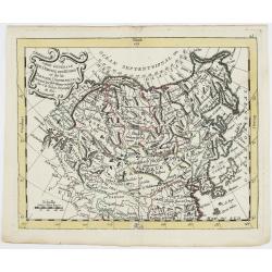
Asia.
Uncommon miniature map from Gibson's "Atlas Minimus, or a New Set of Pocket Maps of the several Empires, Kingdoms, and States of the known World." John Gibson (...
Date: London, 1752-1753
Selling price: ????
Please login to see price!
Sold in 2013
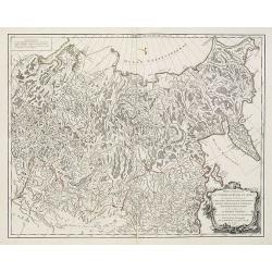
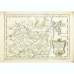
Troisième partie de la carte d'Asie, contenant la Sibérie, et quelques autres parties de la Tartarie. . .
Engraved map of Tartary on two sheets, with country boundaries in out line color. Includes geographic notes and ornamental cartouche by "H. Gravelot, invenit., DeLaf...
Date: Paris, 1754
Selling price: ????
Please login to see price!
Sold in 2012
Suite de la Carte de la Siberie Et le Pays de Kamtschatka.
A detailed 1754 Bellin engraved map of eastern Siberia above and below the Arctic Circle, showing the Sea of Okhotsk, the Kamchatka Peninsula, and Sakhalin Island. The ma...
Date: Paris, 1754
Selling price: ????
Please login to see price!
Sold in 2019
Carte du Kamtchatka.
Jaques Nicolas Bellin (1702-720) was the most important French hydrographer of the 18th century. Sea-atlas 'Hydrographique Français' , 1756-65, atlas to accompany Prévost...
Date: Paris, c. 1755
Selling price: ????
Please login to see price!
Sold in 2016
Carte du Kamtchatka.
A striking map of the Kamchatkan peninsula, that provides a detailed view of the topography with mountains, rivers, lakes, roads and settlements carefully noted. Not many...
Date: Paris, 1755
Selling price: ????
Please login to see price!
Sold in 2016
Partie de l'Empire de Russie comprise en Asie par le Sr. D'Anville. . .
Map of Russia.
Date: Paris, 1759
Selling price: ????
Please login to see price!
Sold in 2009
Tartaria.
Attractive, simple map of Tartary and China.
Date: c. 1760
Selling price: ????
Please login to see price!
Sold in 2013
L' Empire de Russie en Europe et en Asie.
Rigobert Bonne (1727-1795), French cartographer. His maps are found in a.o. Atlas Moderne (1762), Raynal's Histoire Philos. du Commerce des Indes (1774) and Atlas Encyclo...
Date: Paris, 1762
Selling price: ????
Please login to see price!
Sold
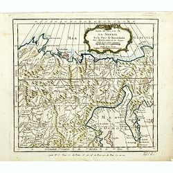
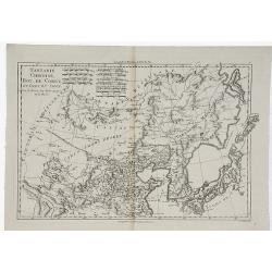
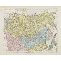
Siberie ou Russie Asiatique, Tartarie Chinoise, pays des Eluts et Isles du Japon.
A detailed map of Siberia and Chinese Tartary. Map includes Corea and Japan to the east. Gilles Robert de Vaugondy (1688–1766), also known as Le Sieur or Monsieur Robert,...
Date: Paris, c 1762
Selling price: ????
Please login to see price!
Sold in 2021
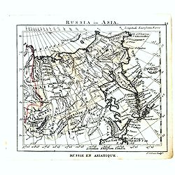
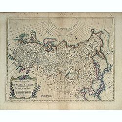
Russia in Asia.
Uncommon miniature map of Siberia, Kamchatka and Hokkaido. The map is of interest for the use of "Little East Sea" for the sea between Japan and Korea.Engraved ...
Date: London, 1761-1763
Selling price: ????
Please login to see price!
Sold
Grande Tartarie et Isles du Japon.
Louis Brion de la Tour (1756-1823), 'Atlas Géneral, Civil et Ecclésiastique', 1766, 'Atlas Général', 1790-98. Louis Charles Desnos (fl.1750-70), Le Rouge's 'Atlas Nouveau...
Date: Paris, 1766
Selling price: ????
Please login to see price!
Sold
Partie Orientale de l 'Empire de Russie. . .
A striking map of western Russia. Includes Tartarian Russia with Siberia and the Bering Strait, and from the Arctic Ocean to the Caspian Sea, Sakhalin and Kamchatka. The ...
Date: Paris, 1771
Selling price: ????
Please login to see price!
Sold in 2021
Des Côtes Nord et Est de L'Asie..
Three maps on one sheet, showing the north eastern coast line of China with Kamchatka. Prepared by Robert de Vaugondy. From his Encyclopedia.
Date: Paris, 1772
Selling price: ????
Please login to see price!
Sold in 2012
Carte de la Tartarie Occidentale.
Jaques Nicolas Bellin (1702-720) was the most important French hydrographer of the 18th century. Sea-atlas 'Hydrographique Français' , 1756-65, atlas to accompany Prévost...
Date: Amsterdam, 1773
Selling price: ????
Please login to see price!
Sold in 2009
Carte de la Tartarie Occidentale.
Jaques Nicolas Bellin (1702-720) was the most important French hydrographer of the 18th century. Sea-atlas 'Hydrographique Français' , 1756-65, atlas to accompany Prévost...
Date: Amsterdam, 1773
Selling price: ????
Please login to see price!
Sold in 2009
Suite de la carte de La Sibérie et le pays de kamtfchatka.
An interesting map of Siberia, with a view on Ochozk Sea.Prepared by Jacques Nicolas Bellin after Dutch sources and included in Prévost d' Exile's "Histoire des Voya...
Date: Paris, 1738-1775
Selling price: ????
Please login to see price!
Sold in 2014
Carte de la Tartarie Occidentale.
An interesting map of Tartary and Siberia.Prepared by Jacques Nicolas Bellin after Dutch sources and included in Prévost d' Exile's "Histoire des Voyages", publ...
Date: Paris, ca. 1775
Selling price: ????
Please login to see price!
Sold in 2014
Carte de la Tartare Orientale.
An interesting map of the Eastern Tartary.Prepared by Jacques Nicolas Bellin after Dutch sources and included in Prévost d' Exile's "Histoire des Voyages", publ...
Date: Paris, 1738-1775
Selling price: ????
Please login to see price!
Sold in 2014
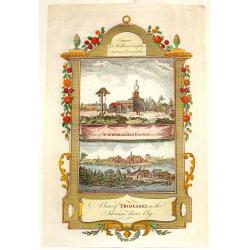
A View of Schorskarskoi Pagost' and 'A View if Trojesski'.
Fine, hand-colored, copperplate engraving featuring two topographical scenes of Siberia - "view of Schorskarskoi Pagost" & "A view of Trojesski on the ...
Date: London, 1777
Selling price: ????
Please login to see price!
Sold in 2013
Carte des parties Nord et Est de L'Asie. . .
Five maps on one sheet, showing the Northern Russian territories in Europe and Asia, including the western coastline from Siberia, with Japan and Korea with the island of...
Date: Paris, 1779
Selling price: ????
Please login to see price!
Sold in 2017
![Fille tatare de Katchin par devant. [together with] Fille tatare de Katchin par derriere.](/uploads/cache/32992-250x250.jpg)
Fille tatare de Katchin par devant. [together with] Fille tatare de Katchin par derriere.
Uncommon copper engraved costume plate from Johann Gottlieb Georgi "Beschreibung aller Nationen des russischen Reichs" (1776), the work stands out for the hand-...
Date: St. Petersbourg, C.G. Müller, 1776-1780
Selling price: ????
Please login to see price!
Sold in 2020
![Feme Tattare de Casan par devant. [together with] Feme Tattare de Casan par derriere.](/uploads/cache/32994-250x250.jpg)
Feme Tattare de Casan par devant. [together with] Feme Tattare de Casan par derriere.
Uncommon copper engraved costume plate from Johann Gottlieb Georgi "Beschreibung aller Nationen des russischen Reichs" (1776), the work stands out for the hand-...
Date: St. Petersbourg, C.G. Müller, 1776-1780
Selling price: ????
Please login to see price!
Sold in 2013
Tattare de Kasan.
Uncommon copper-engraved costume plate from Johann Gottlieb Georgi "Beschreibung aller Nationen des russischen Reichs" (1776), the work stands out for the hand-...
Date: St. Petersbourg, C.G. Müller, 1776-1780
Selling price: ????
Please login to see price!
Sold in 2017
Carte du Kamtchatka Dressee et Gravee par Laurent.
A striking copper engraved map of the peninsula of Kamtchatka in Eastern Russia, with excellent detail of the topography. Numerous roads and settlements are located. The ...
Date: Paris, 1780
Selling price: ????
Please login to see price!
Sold in 2016
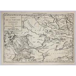
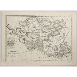
Carte de la Tartarie Independante. . .
An interesting detailed map of the region stretching from Khorasan to Grand Tibet and north to Siberia. By Brion de la Tour in Paris in 1780. From Historie Universale.Lou...
Date: Paris, 1780
Selling price: ????
Please login to see price!
Sold in 2019
Carte d'Une Partie de la Tartarie Vers le sud Ouest et de la Russie ou des Contrees & Carte de la PARTIE Meridionale de la Tartarie.
[TWO MAPS] A striking pair of matching maps of Tartary covering the area (a) between Turkey and Kirgisi and from Siberia to the Caspian sea, and (b) the area between Indo...
Date: Paris, 1780
Selling price: ????
Please login to see price!
Sold in 2021
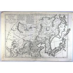
Tartarie Chinoise, Roy, de Coree et Isles du Japon.
A detailed map of Japan, Korea, Manchuria and the Gobi Desert. Highly detailed. From Bonne's Atlas Encyclopedique.Rigobert Bonne (1727-1794) was an influential French ca...
Date: Paris, 1780
Selling price: ????
Please login to see price!
Sold in 2019
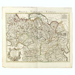
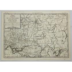
Carte Générale de l'Empire des Russes et de la Tartarie Universelle.
Rare map of Tartary and Russia, including Korea and Japan prepared after J.B.Nolin and published by Monhare for his Atlas Général a l'usage des colleges et maisons d'educ...
Date: Paris, 1783
Selling price: ????
Please login to see price!
Sold in 2023
Carte générale de l'Empire des Russes et de la Tartarie universelle. . .
Scarce map of Russia prepared by Nolin and published by L.J. Mondhare for his Atlas Général a l'usage des colleges et maisons d'education.. Louis Joseph Mondhare was acti...
Date: Paris, 1783
Selling price: ????
Please login to see price!
Sold in 2013
![[Two maps] Carte de la Tartarie Chinoise . . . Carte de la Tartarie indépendante. . .](/uploads/cache/42839-250x250.jpg)
[Two maps] Carte de la Tartarie Chinoise . . . Carte de la Tartarie indépendante. . .
Attractive map of Tartary, ornated with a decorative title cartouche. Boundaries outlined in hand color.Prepared by Le Sieur Janvier, Jean Denis [Robert], French geograph...
Date: Paris, ca 1783
Selling price: ????
Please login to see price!
Sold in 2019
La Tartaria Chinese.
With decorative title cartouche. Covering north eastern part of China, Korea and Hokkaido (here called Jeso-Gasima ).
Date: Venice, 1784
Selling price: ????
Please login to see price!
Sold in 2008
La Tartaria Chinese.
With decorative title cartouche. Covering north eastern part of China, Korea and Hokkaido (here called Jeso-Gasima, Tartary including the Gobi Desert, also Peking and the...
Date: Venice, 1784
Selling price: ????
Please login to see price!
Sold in 2010
Carte de la Tartarie Orientale Manchuria China.
A fine copperplate map of Manchuria China and parts of Siberia Russia by the cartographer Bellin in Paris in 1785. It is from the Italian edition.It features a decorative...
Date: Paris, 1785
Selling price: ????
Please login to see price!
Sold in 2019
Charte das Russische Reich und die von den Tatarn. . .
Map showing the 'Russian Tartary' and as well the 'Asian Tartary', with French title in top.Title cartouche features a three-masted ship in the lower right corner and scr...
Date: Nuremberg, 1786
Selling price: ????
Please login to see price!
Sold in 2023
Charte das Russische Reich und die von den Tatarn. . .
Map showing the 'Russian Tartary' and the 'Asian Tartary', with the French title at the top. The title cartouche features a three-masted ship in the lower right corner, ...
Date: Nuremberg, 1786
Selling price: ????
Please login to see price!
Sold in 2012
(untitled map of eastern Russia with Kamchatka )
Large and detailed map of eastern Russia with parts of Siberia including the lake Baikal by Franz Anton Schraembl (1751-1803). With a small part of today Mongolia and Chi...
Date: Vienna, c1786
Selling price: ????
Please login to see price!
Sold in 2012
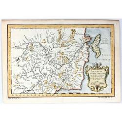
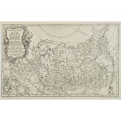
De la Tartarie
Map including the different regions of Tartary. Map centered on the Baikal Lake and the Karzana Lake. In the right and left margins, there are a long explication text. Je...
Date: Paris, 1787
Selling price: ????
Please login to see price!
Sold in 2010
Karte ploskaja ot' goroda Jakucka do Ochockago porta po rekam' Leny Aldana Maji Jodomy i Urakom' do Penzinskavo morja
A detailed map of the Urak River near Okhotsk, eastern Siberia from an unidentified source. The title of the map also in French " Carte dressée et levée en allant de...
Date: Paris, Nyon, Philippe de Prétot, 1787
Selling price: ????
Please login to see price!
Sold in 2014
Tartarie Independante.
A fine, detailed, antique map of Tartary from the Black Sea to China and from Siberia to Tibet, by Bonne, published in the 1787 “Atlas Encyclopedique”.Rigobert Bonne (172...
Date: Paris, 1787
Selling price: ????
Please login to see price!
Sold in 2021
Tartarie Chinoise, Roy. De Coree et Isles du Japan.
A fine map of the Asian region including Japan, Korea, Manchuria and the Gobi Desert. Highly detailed. From Bonne's 'Atlas Supplement'.Rigobert Bonne (1727–1795) was a Fr...
Date: Paris, 1787
Selling price: ????
Please login to see price!
Sold in 2023
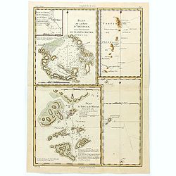
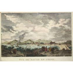
Plan de la Baye d'Awatska sur la Cote du Kamschatka
An interesting map of several countries along the east coast of Asia. In addition to Kamchatka, it includes Partie du Japon ou Nippon, Plan du Typa ou de Macao, Plan du H...
Date: Paris, 1788
Selling price: ????
Please login to see price!
Sold in 2023
Russia in Asia.
Uncommon miniature map from Gibson's "Atlas Minimus, or a New Set of Pocket Maps of the several Empires, Kingdoms and States of the known World".
Date: London, 1792
Selling price: ????
Please login to see price!
Sold in 2011
![[No tittle] Lac salé de Bogdo Montagne de Bogdo.](/uploads/cache/29184-250x250.jpg)
[No tittle] Lac salé de Bogdo Montagne de Bogdo.
Map of Mountains and the Salt Lake of Bogdo in Russia near the border of Kazakhstan, from a second French edition of Peter Simon Pallas' Voyages du Professeur Pallas, dan...
Date: Paris, Maradan, 1794
Selling price: ????
Please login to see price!
Sold in 2012
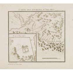
Carte des environs d'Ablaïkit.
Map from a second French edition of Peter Simon Pallas' Voyages du Professeur Pallas, dans Plusieurs Provinces de l’Empire de Russie et dans l’Asie Septentrionale, engrav...
Date: Paris, Maradan, 1794
Selling price: ????
Please login to see price!
Sold in 2012
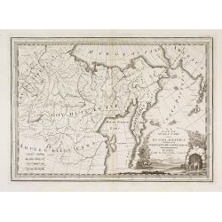
La Parte Orientale della Russia Asiatica Delineata Sulle Ultime Osservazioni. . .
Uncommon map of Tartary and Bering Street with western Alaska, includes Aleutians, but lacking detail. With page number Volume 2, No. 66 in upper right corner. From Cassi...
Date: Rome, 1796
Selling price: ????
Please login to see price!
Sold in 2015
La Tartaria Chinese. Siena 1796 Presso Pazzini Carli.
Rare map of Tartary, with Korea and Japan published by Carli Pazzini in Siena and included in " Atlante Geografico, prima stesura delle opera dell’abate Bartolomeo B...
Date: Siena, 1796
Selling price: ????
Please login to see price!
Sold in 2015
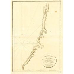
Plan de la Baie de Langle, situee a la partie Ouest de l' Isle de Choka
Jean François Galoup, Comte de la Pérouse (1741-88), outstanding French explorer and hydrographer. ' Voyage autour du Monde?Atlas', 1797.A map of the bay of Langle on Cho...
Date: Paris, 1797
Selling price: ????
Please login to see price!
Sold in 2009
La Tartaria Cinese delineata sulleultime osservazioni.
Uncommon 1798 edition of this map of Chinese Tartary (present-day Mongolia and Manchuria) and Korea by Giovanni Maria Cassini.The map includes good detail of the cities a...
Date: Rome, 1798
Selling price: ????
Please login to see price!
Sold in 2010
Gezigt van de stad en haven van St. Petrus en St. Paul aan Kamtschatka.
Captain James Cook (1728-79), explorer, circumnavigator and hydrographer. Three voyages, 1768-71, 1772-75 and 1776-79. From 1778 on printed editions of ' Captain Cook's T...
Date: Leiden, 1795-1803
Selling price: ????
Please login to see price!
Sold
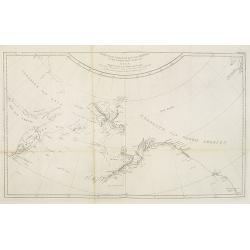
Kaart van de noord-west kust van Amerika en de noord-oost kust van Asia. Opgenoomen in de Jaaren 1778 en 1779.
Captain James Cook (1728-79), explorer, circumnavigator and Hydrographer. Three voyages, 1768-71, 1772-75 and 1776-79. From 1778 on printed editions of ' Captain Cook's T...
Date: Leiden, 1795-1803
Selling price: ????
Please login to see price!
Sold in 2010
Östlicher Theil des Russischen Reiches oder Sibirien mit den Kurilischen, Aleutischen und Fuchs-Inseln. . .
Scarce map of Eastern part of Russia, prepared by F.L. Güssefeld and published by Homann Heirs.Engraved by I.B.Slbrig.
Date: Nuremberg, ca. 1805
Selling price: ????
Please login to see price!
Sold in 2014
Siberie ou Russie Asiatique, Tartarie Chinoise, Pays des Eluts et Isles du Japon.
Map of the Kamchatka peninsula, Russian Far East., Korea, Japan, with Hokaido labeled "Terre del Jeso".By C. F. Delamarche, successor of Robert de Vaugo...
Date: Paris, 1794 - 1806
Selling price: ????
Please login to see price!
Sold in 2009
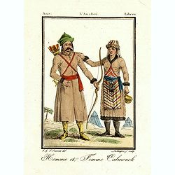
Homme et femme Calmouck.
Originally hand-colored mezzotint of two men from the autonomous Republic of Kalmykia dressed in native garb, engraved by Félix Mixelle and Lachaussée Jeune after Jacques...
Date: Paris,1801-1806
Selling price: ????
Please login to see price!
Sold in 2016
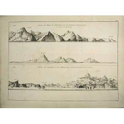
Views of the coast of Kamchatka.
An original view in imperial folio size, originating from the original first edition (Russian & German) of Krusenstern's atlas to his voyage around the world: Atlas k...
Date: St. Petersburg, 1813-1814
Selling price: ????
Please login to see price!
Sold in 2011
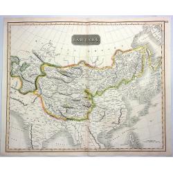
Tartary.
A fine hand colored 1814 Thomson map of central and east Asia, covering southern Tartary, Tibet, Mongolia, and almost all of Central Asia extending from the Caspian Sea t...
Date: Edinbourgh, 1814
Selling price: ????
Please login to see price!
Sold in 2021
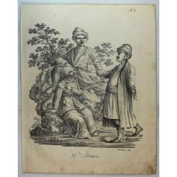
Group of Tartars (IV ter Stamm).
Three oriental figures in a landscape; a female and two males. From a natural history or ethnographic folio by renowned Swiss artist and lithographer Carl (Karl) Joseph B...
Date: Zurich, 1816
Selling price: ????
Please login to see price!
Sold in 2019
