Browse Listings in Asia > Near / Middle East
Typus Aetiologicus II.
Rare map centered on Armenia, Georgia, Black Sea and the Caspian Sea, with the Middle East from the Eastern Mediterranean to the borders of India. Outline coloring shows ...
Date: Nuremberg, 1739
Selling price: ????
Please login to see price!
Sold in 2009
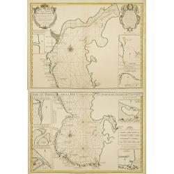
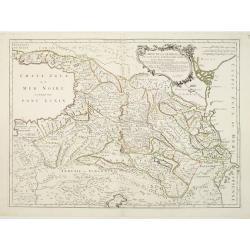
Carte Marine de la Mer Caspiene levée Suivant les Ordres.. (2 maps)
Accurate map of the Caspian. Dutch edition based upon earlier maps by De L'Isle who re-drew Verden's original map. Embellished with 2 cartouches and 8 insets.The map is f...
Date: Amsterdam c. 1744
Selling price: ????
Please login to see price!
Sold
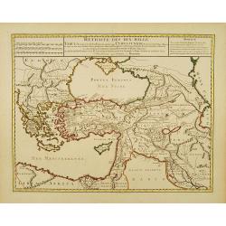
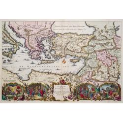
Retraite des Dix Mille..
Very decorative map of the Near East: it represents the area which was the theatre of the Ten Thousand's march to the Battle of Cunaxa and back to Greece (401 BC-399 BC),...
Date: Amsterdam c. 1745
Selling price: ????
Please login to see price!
Sold
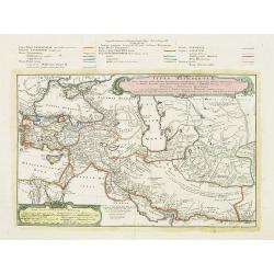
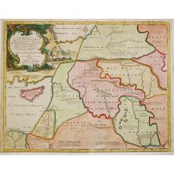
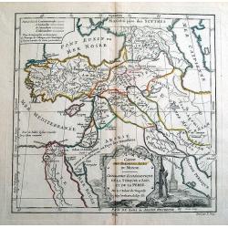
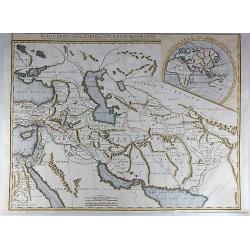
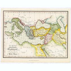
Alexandri Magni Imperium et Expeditio.
The map represents the theatre of Alexander the Great's conquests between the Black Sea and Indus River, today's Armenia, Iraq, Iran, Afghanistan, etc.The map is from a D...
Date: Amsterdam c. 1745
Selling price: ????
Please login to see price!
Sold
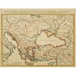
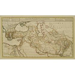
Imperii Orientalis et Circumjacentium Regionum. .
Very decorative copper-engraved map representing the extent of Constantine VII Porphyrogenitos' empire.The map is from a Dutch edition of De L'Isle's work entitled, Atlas...
Date: Amsterdam c. 1745
Selling price: ????
Please login to see price!
Sold
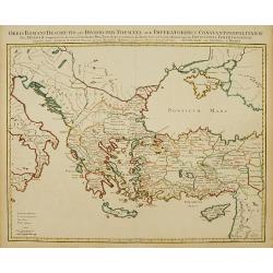
Orbis Romani Descriptio seu Divisio per Themata. .
Covens and Mortier's Map of the Roman World is a copperplate engraving based on an earlier map by Guillelmo De L'Isle (1675-1726), Geographer to the King of France. The s...
Date: Amsterdam c. 1745
Selling price: ????
Please login to see price!
Sold
Geographifche Beschryvinghe van de Wandeling..
Title: "Geographifche Beschryvinghe van de Wandeling der Apostelen ende De Reysen Pauli"This is an original map from a Dutch bible of 1748 made by Stoopendaal. ...
Date: Amsterdam 1748
Selling price: ????
Please login to see price!
Sold
Afbeelding van all de Landen gelegen tusschen de Middellandsche, Zwarte, Caspische, Persische en Rode Zeën.
Willem Albert Bachiene (1712-1783), Dutch geographer in Maastricht. Most important work ' Heilige Geographie', a work on the Holy Land. Mathijs Schalenkamp published in 1...
Date: Gorichem, Nicolaas Goetzee, 1748
Selling price: ????
Please login to see price!
Sold
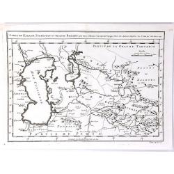
Carte de Karazm, Turkestan et Grand Bukarie
A fine copper engraved map by Bellin, centred on Uzbekistan, showing the Caspian and Aral seas. Published in “ Histoire Generale des Voyages” by Abbe A. F. Prevost in Par...
Date: Paris, 1749
Selling price: ????
Please login to see price!
Sold in 2019
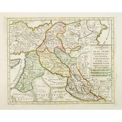
Nieuwe kaart van Irak Arabi, Kurdistan, Diarbek. . .
Detailed map including the northern part of the Arabian peninsular, Palestine, Iraq, Iran and the eastern part of Cyprus.
Date: Amsterdam, 1750
Selling price: ????
Please login to see price!
Sold in 2017
![[Lot of 4 maps] Afbeeldinge der Oostersche Landen. / van ' T Land Kanaan.](/uploads/cache/100146-250x250.jpg)
[Lot of 4 maps] Afbeeldinge der Oostersche Landen. / van ' T Land Kanaan.
Willem Albert Bachiene (1712-1783), Dutch geographer in Maastricht. Most important work ' Heilige Geographie', a work on the Holy Land. A map of the Near East and a map o...
Date: Amsterdam, c. 1750
Selling price: ????
Please login to see price!
Sold in 2022
De Gelegenheyt van 't Paradys en 't Landt Canaan, mitsgaders d, eerste bewoonde landen der Patriarchen?door C.D./Albert Schut Schulp.
Dutch so-called ' Staten' bibles, published between 1637 and c. 1760, contained 5 maps: The World, 'Paradise', The Perigrinations, The Promised Land Canaan, The Travels o...
Date: Amsterdam / Leiden, 1757
Selling price: ????
Please login to see price!
Sold
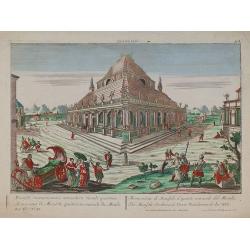
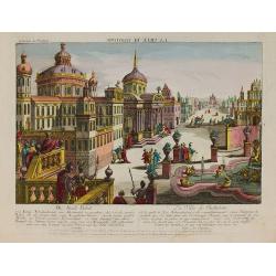
Mausolée.
In the eighteenth and nineteenth centuries there were many popular speciality establishments in Paris, Augsburg and London which produced optical viewing devices and spec...
Date: Augsburg 1770
Selling price: ????
Please login to see price!
Sold in 2010
La ville de Babylone.
In the eighteenth and nineteenth centuries there were many popular speciality establishments in Paris, Augsburg and London which produced optical viewing devices and spec...
Date: Augsburg 1770
Selling price: ????
Please login to see price!
Sold in 2010
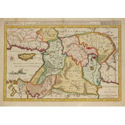
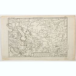
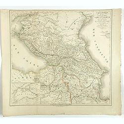
Carte de la Géorgie &c. des pays situés entre la Mer Noire et la Mer Caspienne..
Detailed map of Georgia, Armenia and Azerbaijan.Santini gives credit to Homann Heirs in the cartouche.
Date: Venise 1776
Selling price: ????
Please login to see price!
Sold
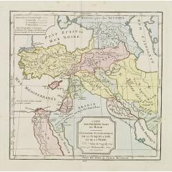
CARTE DES PREMIERS AGES DU MONDE
Beautiful ancient map, showing the eastern Mediterranean and the Near East. Includes parts of the present countries of Cyprus, Turkey, Russia, Black Sea, Caspian Sea, Arm...
Date: Paris, 1780
Selling price: ????
Please login to see price!
Sold in 2014
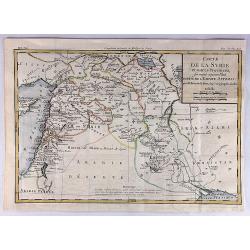
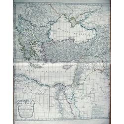
Carte de la Syrie et Autres Provinces Formant Aujourd'hui Partie de L'Empire Ottoman.
A fine map of Syria and other regions including; Roum, Irakarabia, Khosistan, Armemia, Kurdistan and Palestine. Also shown is most of the island of Cyprus. Louis Brion de...
Date: Paris, 1780
Selling price: ????
Please login to see price!
Sold in 2020
Carte de la Perse, de la Géorgie, et de la Tartarie. . .
A nice detailed map that shows Persia, Caspian Sea, Persian Gulf, etc. by the prolific French cartographer Rigobert Bonne (1727-1795), who, flourished between about 1760 ...
Date: Paris, 1780
Selling price: ????
Please login to see price!
Sold in 2023
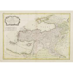
Carte de la Turquie d'Asie..
Attractive map of the Near East centered on Turkey, ornated with a rococo title cartouche. A curious shape for Cyprus. Boundaries outlined in hand color.From theAtlas mod...
Date: Paris ca 1783
Selling price: ????
Please login to see price!
Sold
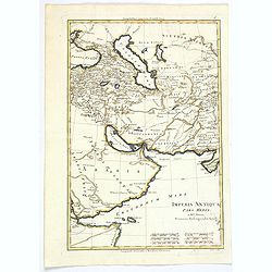
Imperia Antiqua. Pars Media.
A map of the Near East from Rigobert Bonne's "Atlas Encyclopedique." Rigobert Bonne (1727-1795) was one of the most important cartographers of the late 18th cen...
Date: Paris, 1787
Selling price: ????
Please login to see price!
Sold in 2021
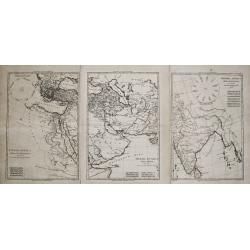
Imperia Antiqua. Pars Occidentalis/ Pars Media/ Pars Orientalis.
Rigobert Bonne (1727-1795), French cartographer. His maps are found in a.o. Atlas Moderne (1762), Raynal's Histoire Philos. du Commerce des Indes (1774) and Atlas Encyclo...
Date: Paris, 1787-1788
Selling price: ????
Please login to see price!
Sold
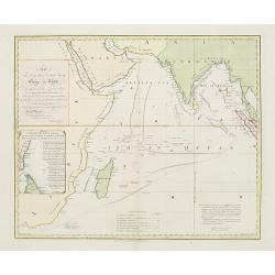
This chart .. tracks of ships in the different monsoons..
Curious over-sized prepared by Benjamin Lacam, showing the Indian Ocean, including Cape of Good Hope, Arabia, India and Malay Peninsula. In the Ocean several tracks are ...
Date: London, 1794
Selling price: ????
Please login to see price!
Sold in 2018
Orbis Romani pars Orientalis
Large map of the Eastern Roman Empire. Extends from Greece to Babylonia, Arabia and Armenia. Includes Thebes in Egypt, the eastern part of the Mediterranean, and the Blac...
Date: London, 1794
Selling price: ????
Please login to see price!
Sold in 2013
Partie Orientale de la Carte des Anciennes Monarchies.
This striking map depicts the eastern part of the Ancient World, including the Near East, Cyprus, Black Sea, Caspian Sea, Iran and Iraq. An inset map showing the eastern ...
Date: Paris, ca 1800
Selling price: ????
Please login to see price!
Sold in 2017
![[Middle East Map]](/uploads/cache/98780-250x250.jpg)
[Middle East Map]
Very large map of the region north and east of the Mediterranean Sea. It covers the are from Eastern Italy to Western Persia, and from The Crimea to Egypt. It includes co...
Date: England, ca. 1800
Selling price: ????
Please login to see price!
Sold in 2017
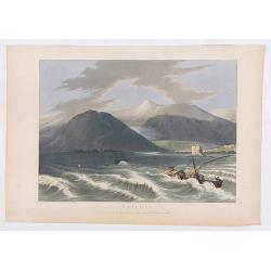
Tripoli.
Showing a few boats and harbour of Tripoli in Libanon, sketched on the spot by F.B. Spilsbury and drawn by D. Orme for "Picturesque Scenery in the Holy Land and Syri...
Date: London, 1803
Selling price: ????
Please login to see price!
Sold in 2022
Cartes des premiers ages du monde. Géographie Ecclédiastique de la Turquie, d''Asie et de la Perse.
Map of ancient Turkey, Cyprus, Persia and Near and Middle East.By C. F. Delamarche, successor of Robert de Vaugondy, Geographer.
Date: Paris, ca.1806
Selling price: ????
Please login to see price!
Sold
Places Mentioned in the Old & New Testament with those remote from the Holy Land.
Map of the Mediterranean with places of the Old and New testament underlined. From "The Scripture atlas or a series of maps…"
Date: London, 1812
Selling price: ????
Please login to see price!
Sold in 2018
Carte générale du pays entre les mers Noire et Caspienne, avec la désignation des nouvelles frontières de la Russie et de la Perse. . .
A stunning map of Georgia, Armenia, and Azerbaijan.
Date: Paris, 1819
Selling price: ????
Please login to see price!
Sold in 2018
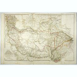
Central Asia comprising Bokhara, Cabool, Persia, The river Indus, & countries eastward of it.
An important detailed map of Central Asia shows the routes of Lieut. Alexander Burnes. It also shows both the western and eastern coasts of the Persian Gulf in much detai...
Date: London, 1834-1836
Selling price: ????
Please login to see price!
Sold
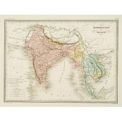
Hindoustan et Indo-Chine.
Detailed map of India, Pakistan, Thailand, Malaysia, Vietnam, etc.From Malte-Brun's Atlas Géographie Universelle..., revised by Jean Jacques Nicolas Huot.This very fine e...
Date: Paris 1837
Selling price: ????
Please login to see price!
Sold
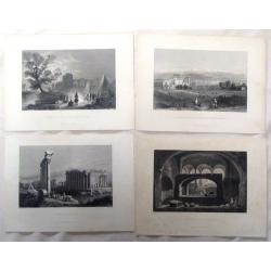
Four Bartlett steel engravings from the Middle East.
Four fine steel engraving prints by William Bartlett. Included are: - SEPULCHRE AT SELEUCIA - RUINS OF BALBEC - GENERAL VIEW OF BALBEC AND ANTI-LIBANUS - ENCAMPMENT A...
Date: London, 1837
Selling price: ????
Please login to see price!
Sold in 2016
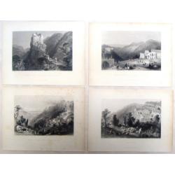
Four Middle East Bartlett steel engravings.
Four fine steel engraving prints by William Bartlett. Included are: - SELUCIA - BETHDDEIN - PLACE OF THE PRINCE OF THE DRUSES - GOTHIC CASTLE IN A VALLEY NEAR BATROU...
Date: London, 1837
Selling price: ????
Please login to see price!
Sold in 2016
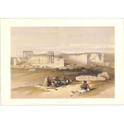
Ruins of Baalbec. May 5th, 1839.
Roberts was the first independent, professional British artist to travel so extensively in the Near East. His tour in 1838-9 produced 272 sketches, a panorama of Cairo an...
Date: London: F.G. Moon. 1842
Selling price: ????
Please login to see price!
Sold in 2023
![Baalbec [The Sanctuary, 4th-5th May, 1839].](/uploads/cache/1126552-250x250.jpg)
Baalbec [The Sanctuary, 4th-5th May, 1839].
Baalbek is a town in the Beqaa Valley of Lebanon situated east of the Litani River. After Alexander the Great conquered the Near East in 334 BC, the existing settlement w...
Date: London: F.G. Moon. 1842
Selling price: ????
Please login to see price!
Sold in 2023
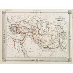
Empire d'Alexandre.
Decorative map showing the empire of Alexander the Great. Prepared by A.H.Dufour, published by Basset, rue de Seine 33, Paris. The engraver of the map was Ch.Smith. Inclu...
Date: Paris 1846
Selling price: ????
Please login to see price!
Sold in 2010
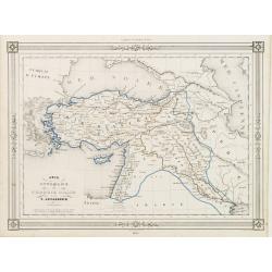
Asie Ottomane ou Turquie d'Asie..
Decorative map of Turkey and Cyprus, prepared by J.G.Barbié du Bocage.Engraved by Ch.Smith, published by Basset who was established in Paris, rue de Seine 33. From atlas ...
Date: Paris, 1846
Selling price: ????
Please login to see price!
Sold in 2009
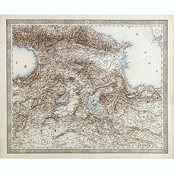
(Map of Armenia and Iran)
Detailed map of Armenia, Iran, Iraq and part of Turkey in elaborate floral borders. Joseph Scheda in Vienna 1845 - 1847.
Date: Vienna, 1845-1847
Selling price: ????
Please login to see price!
Sold in 2015
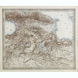
(Map of Armenia and Iran)
Detailed map of Armenia, Iran, Iraq and part of Turkey in elaborate floral borders. Published by Joseph Scheda in Vienna.
Date: Vienna, 1845-1847
Selling price: ????
Please login to see price!
Sold in 2021
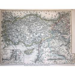
Die Asiatische Türkey 1854.
A superbly steel-engraved map from the rare German Atlas: Meyer's Zeitungs-Atlas, considered to be the finest German Atlas of the mid 19th century! Revised edition for th...
Date: Hildburghausen, 1857
Selling price: ????
Please login to see price!
Sold
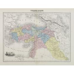
Turquie d'Asie et les Provinces du Caucase.
A decorative map of Turkey, Syria, Iraq, and Iran from Géographie Universelle, Atlas Migeon, published by J. Migeon. With an engraving of the ancient city of Smyrna in Iz...
Date: Paris, 1874
Selling price: ????
Please login to see price!
Sold in 2009
