Browse Listings in Asia > Holy Land & Jerusalem
![[Palestine]](/uploads/cache/25597-250x250.jpg)
[Palestine]
A more than 100 year old Russian map of Palestine (present day Israel) printed in lithography. Published by one of the most successful publishers of St. Petersburg A.Ilji...
Date: St. Petersburg, c.1905
Selling price: ????
Please login to see price!
Sold in 2009
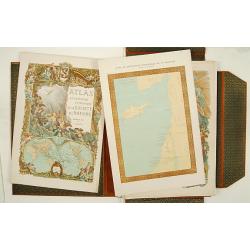
Atlas de géographie economique de la Paléstine.
Impressive atlas including historical, geographical and economical maps of Israel from the earliest time. The 135 maps are printed in color. One of the 3 title pages with...
Date: Paris 1932
Selling price: ????
Please login to see price!
Sold
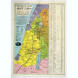
Pilgrim's map of the Holy Land : for biblical research, the journey's and deed's of Jesus Christ.
Fine map of the Holy Land with extensive color keys, short legend and key list to the main towns of the region.The map was prepared by Th.F.Mathesy Ph.D. and according to...
Date: Jerusalem, 1942
Selling price: ????
Please login to see price!
Sold in 2010
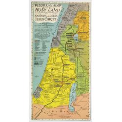
Pilgrim's Map of the Holy Land. . .
A large and striking map of the Holy Land, published in Nazareth during the Second World War. The map shows from the Port of Sidon in the north, south to Gaza, mentioning...
Date: Nazareth, 1942
Selling price: ????
Please login to see price!
Sold in 2020

Israel
Decorative poster advertising flights to Israel made by Georges Mathieu. The poster is one of a series of 15 composed of posters of Greece, Israel, Germany, Great Britain...
Date: Paris, 1967
Selling price: ????
Please login to see price!
Sold in 2023
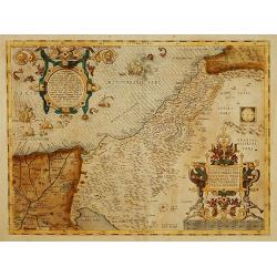
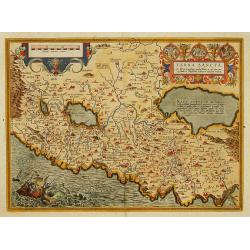
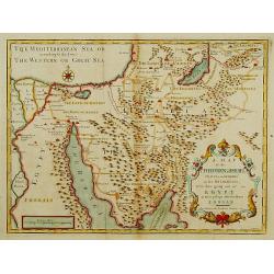
Palestinae sive totius Terrae Promissionis nova descriptio?
A new description of Palestine or the whole Promised Land. The shoreline runs from Berytus (Beirut) to the Nile Delta, reaching inland east of the Jordan and in the south...
Date: Antwerp 1575.
Selling price: ????
Please login to see price!
Sold
Terra sancta a Petro Laicstain perlustrata..
The Holy Land described by Petrus Laicstain, a Dutch astronomer who collected topographic material on Palestine during his stay there in 1556. Designed by Christian Schro...
Date: Anvers 1612.
Selling price: ????
Please login to see price!
Sold
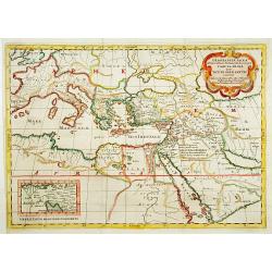
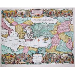
GEOGRAPHIAE SACRAE ex Veteri? TABULA PRIMA?
Map of the world according to the Sacred Geography, showing most of the Mediterranean and of the Middle East. Chanaan is shown before the conquest by the Jews. Inset: Isr...
Date: Paris 1662.
Selling price: ????
Please login to see price!
Sold
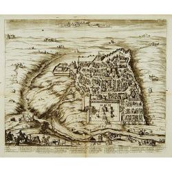
Ierusalem.
Engraved bird's eye plan, surrounded by biblical figures and objects, after N. Berchem. French text legends held by winged angels.From the large folio French Elzevier bib...
Date: Leiden, 1669.
Selling price: ????
Please login to see price!
Sold
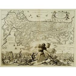
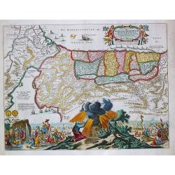
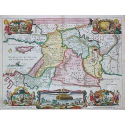
Sortie des Enfans d'Israel hors d'Egypte...
Map of the Holy Land. At the bottom, Moïse is depicted receiving the Tables of the Law on the Sinai Mount while on both sides are represented the scene of the escape out...
Date: Leiden, 1669.
Selling price: ????
Please login to see price!
Sold
De Stadt Ierusalem zoot Hedendaeghs Bevonden wordt.
View of Modern Jerusalem. Legend along the bottom.From: Olfert Dapper Naukeurige beschryving van gantsch Syrie en Palestyn of Heilige Lant. Pt. II, p.327.Drawn after Bern...
Date: Amsterdam 1677.
Selling price: ????
Please login to see price!
Sold
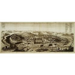
Ierusalem.
A panoramic view of the holy city of Jerusalem. With 52 descriptive points key in German and Latin.From: Dapper, Olfert Naukeurige beschryving van gantsch Syrie en Palest...
Date: Amsterdam 1677.
Selling price: ????
Please login to see price!
Sold
Perigrinatie ofte Veertich-jarige Reyse der Kinderen Israels.
Dutch so-called "Staten" bibles, published between 1637 and c. 1760, contained 5 maps: The World, "Paradise", The Perigrinations, The Promised Land Ca...
Date: H. Keur en M. Doornik, Dordrecht-Amsterdam, 1686.
Selling price: ????
Please login to see price!
Sold
Jerusalem.
Dutch so-called "Staten" bibles, published between 1637 and c. 1760, contained 5 maps: The World, "Paradise", The Perigrinations, The Promised Land Ca...
Date: Amsterdam, 1690.
Selling price: ????
Please login to see price!
Sold
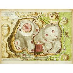
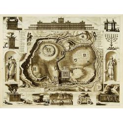
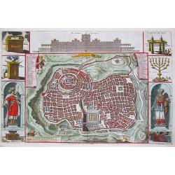
Description de l'ancienne Jerusalem selon Villalpand.
Richly detailed imaginary plan of ancient Jerusalem seen from the east. At bottom center of the plan itself, the Temple of Solomon is shown: upper left, the City of David...
Date: [Paris ca. 1730]
Selling price: ????
Please login to see price!
Sold
A Map of the Children of Israel's Travels and Marches?
From Augustin Antoine Calmet, A historical, geographical?dictionary of the Holy Bible, London, 1732. Vol. I, between PP. 384-385.
Date: [London 1732]
Selling price: ????
Please login to see price!
Sold
De Gelegentheyt van t' Paradys en t' Landt Canaan, mitsgaders d' eerst bewoonde Landen der Patriarchen.
Dutch so-called "Staten" bibles, published between 1637 and c. 1760, contained 5 maps: The World, "Paradise", The Perigrinations, The Promised Land Ca...
Date: Amsterdam / Dordrecht, Pieter Keur, Pieter Rotterdam em Pieter Rotterd
Selling price: ????
Please login to see price!
Sold
De Beschryving van de Reysen Pauli en Van de Andere Apostelen.
The Dutch so-called ' Staten' bibles published between 1637 and c. 1760, contained 5 maps: The World, ' Paradise', The Perigrinations, The Promised Land Canaan, The Trave...
Date: Amsterdam / Dordrecht, Pieter Keur, Pieter Rotterdam en Pieter Rotterd
Selling price: ????
Please login to see price!
Sold
