Browse Listings in Asia > Holy Land & Jerusalem
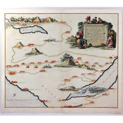
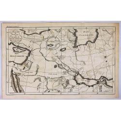
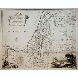
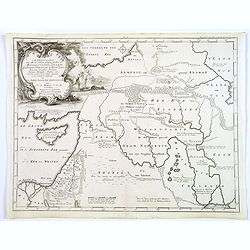
Voyage des Enfants D'Israel dans le Desert Depuis Leur Sortie D'Egypte par la Mer Rouge
An interesting map illustrating the flight of the Children of Israel from Egypt to the Promised Land and their wandering in the desert in what is now Arabia. Mount Sinai ...
Date: Amsterdam, 1725
Selling price: ????
Please login to see price!
Sold in 2017
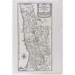
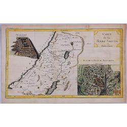
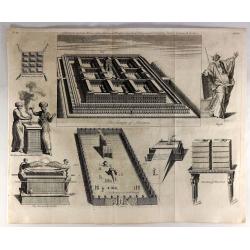
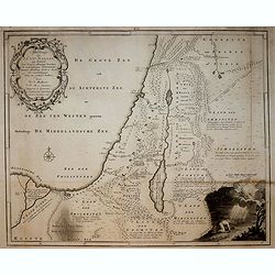
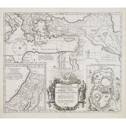
Tabula terrae promissionis ab Auctore Commentarii in Josue et a Liebaux Geographo Incisa.
Uncommon map of the Holy Land, based upon the commentary of Joshua. Division of the territory into 12 tribes. Wind rose in lower left. An unusual Italian version of Augus...
Date: Venice, 1726
Selling price: ????
Please login to see price!
Sold in 2020
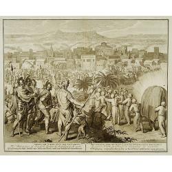
The Destruction of Jericho by Joshua, by the falling of the walls.
From one of the finest editions of one of the finest books of bible prints. Titles are in Hebrew, English, German, Latin, French, and Dutch.
Date: Amsterdam 1728
Selling price: ????
Please login to see price!
Sold
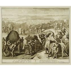
The Israelites passe the river Jordan.
From one of the finest editions of one of the finest books of bible prints. Titles are in Hebrew, English, German, Latin, French, and Dutch. After a design by G.Hoet(1648...
Date: Amsterdam 1728
Selling price: ????
Please login to see price!
Sold
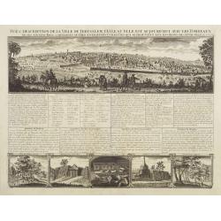
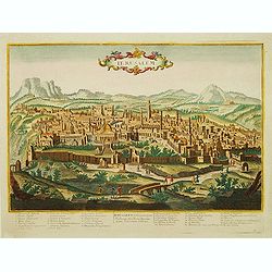
Vue & discription de la Ville de Jerusalem..avec Tombeaux..
This copper-engraving shows a panoramic view of Jerusalem, two insets of mount "Liban" and three insets of the tombs De Zacharie, Des Rois and D'Absalom.Zachari...
Date: Amsterdam, 1728
Selling price: ????
Please login to see price!
Sold
Wahrer und Grundlicher Abriss der Welt-beruhmten und Hochheiligen Stadt Jerusalem aller angrenzenden Oertern und Heiligt³mern wie auch anderer Merckwurdigkeiten welche durch das Leben, Wunderzeichen, Leiden, Todt, und Auferstehung Jesu Christi seynd gehei
An important and absolutely rare chronogram-dated view of Jerusalem.Only a handful copies are known : one in the Eran Laor Collection at the Jewish National and Universit...
Date: Vienna, 1728
Selling price: ????
Please login to see price!
Sold in 2009
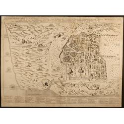
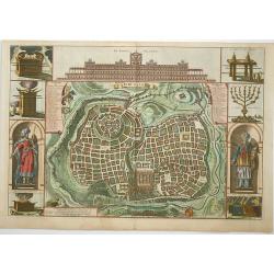
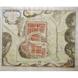
De Stadt Ierusalem.
A great bird's eye plan of the holy city flanked by engravings of religious icons. At the bottom are an elevation of the Temple of Solomon and a panoramic view of Jerusal...
Date: Amsterdam, 1728
Selling price: ????
Please login to see price!
Sold in 2009
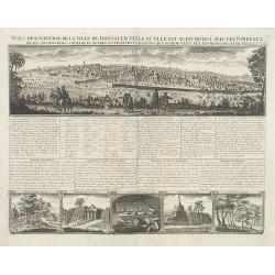
Vue & discription de la Ville de Jerusalem.. Avec Tombeaux..
This copper-engraving shows a panoramic view of Jerusalem, two insets of mount "Liban" and three insets of the tombs De Zacharie, Des Rois, and D'Absalom.Zachar...
Date: Amsterdam, 1728
Selling price: ????
Please login to see price!
Sold in 2010
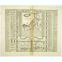
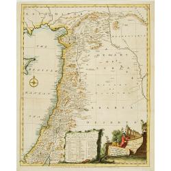
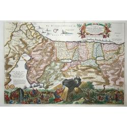
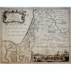
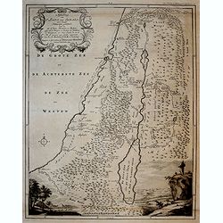
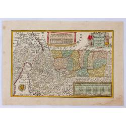
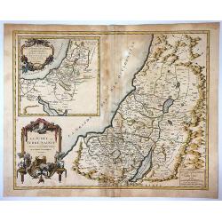
Suite de la généalogie ou chronologie des rois patriarches. . .
Page with two historical maps. One showing Israel and Judæa with a part of Syria, "Arabie Heureuse", and Egypt; the other one showing the region occupied by Is...
Date: Amsterdam, 1728
Selling price: ????
Please login to see price!
Sold in 2013
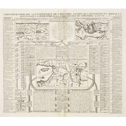
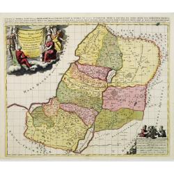
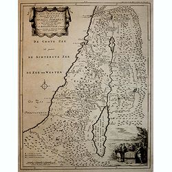
Carte pour conduire à l'intelligence de l'histoire sacrée qui renferme en abrégé la généalogie, la géographie et la chronologie de l'Histoire Sainte. Seconde période du Monde depuis Moyse jusqu'au règne des Rois d'Israël et de Juda.
A Map Showing the understanding of Sacred History, containing an abbreviated genealogy, geography and chronological history of the Bible.Henri Abraham Chatelain (1684 –...
Date: Amsterdam, 1728
Selling price: ????
Please login to see price!
Sold in 2013
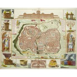
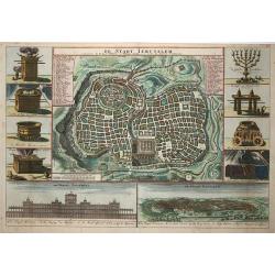
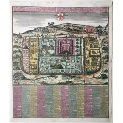
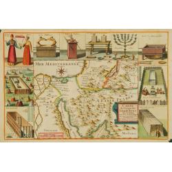
Ierusalem
Great bird's eye plan of the holy city flanked by engravings of religious icons, and two priests. At the top is a large elevation of the Temple of Solomon and at bottom i...
Date: Amsterdam 1729
Selling price: ????
Please login to see price!
Sold
Voyage des Enfans F'Israel Dans le Desert depuis Sortie D'Egypte par la Mer Rouge Insquest au Pays de Canaan.
Decorative map of the HOly Land with a bird's eye view of the Sinai Desert, showing the wanderings of Moses and the Children of Israel through Egypt to Canaan. It feature...
Date: Amsterdam, 1729
Selling price: ????
Please login to see price!
Sold in 2016
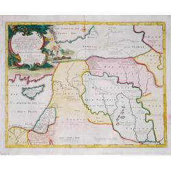
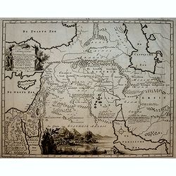
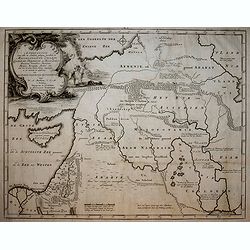
Carte du Premier Age, ou Situation du Paradis Terrestre.
A striking map of the ancient Middle East. It is from METHODE POUR ETUDIER L’HISTOIRE by L’Abbe Lenglet du Fresnoy, published in Paris in 1729. The map is quite rare ...
Date: Paris, 1729
Selling price: ????
Please login to see price!
Sold in 2017
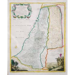
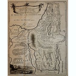
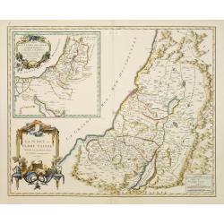
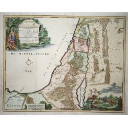
Carte de la Terre Sainte ou Palestine.
A striking map of the Holy Land (Palestine). It is from "METHODE POUR ETUDIER L’HISTOIRE" by L’Abbe Lenglet du Fresnoy, published in Paris in 1729. The map ...
Date: Paris, 1729
Selling price: ????
Please login to see price!
Sold in 2020
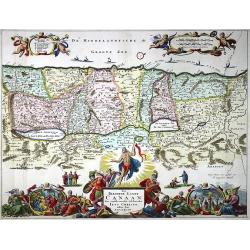
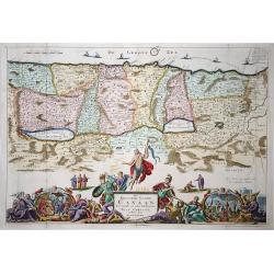
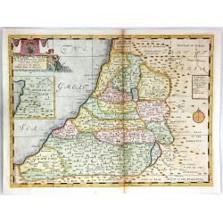
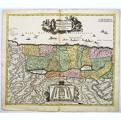
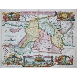
Het Beloofde Landt Canaan door wandelt van onsen Salichmaecker Iesu Christo, neffens syne Apostelen.
A beautifully engraved map of the ancient land of Canaan which roughly corresponds to present-day Israel. Cherubs hold up a draped cloth of key symbols, also a scale pane...
Date: Amsterdam, Pieter and Jacob Keur, 1729
Selling price: ????
Please login to see price!
Sold in 2020
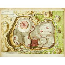
Description de l'ancienne Jerusalem selon Villalpand.
Richly detailed imaginary plan of ancient Jerusalem seen from the east. At bottom center of the plan itself, the Temple of Solomon is shown: upper left, the City of David...
Date: Paris ca. 1730
Selling price: ????
Please login to see price!
Sold
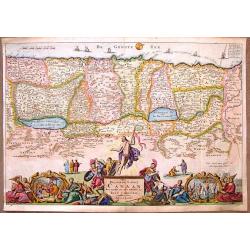
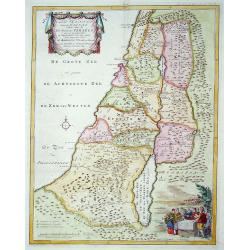
Het Beloofde Landt Canaan..
Het Beloofde Landt Canaan door wandelt van onsen Salichmaecker Iesu Christo, neffens syne Apostelen. Fine map of Israel with north oriented to right. Large decorative tit...
Date: Amsterdam, 1730
Selling price: ????
Please login to see price!
Sold in 2009
Het Beloofde Landt Canaan Door Wandelt van Onsen Salichmaecker Iesu Christo Neffens Syne Apostelen.
Oriented to the West, this map covers the Holy Land to just beyond the Jordan River. This map was published by the Keur family in the "KEUR BIBLE".Daniel Stoope...
Date: Amsterdam, 1730
Selling price: ????
Please login to see price!
Sold in 2018
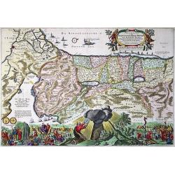
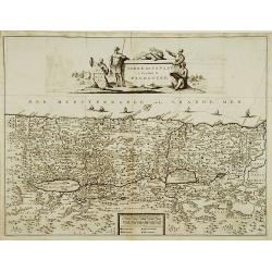
Perigrinatie ofte Veertich-Iarige Reyse Der Kinderen Israels uyt Egypten, door de Roode-Zee, ende de Woestyne,Tot in't Beloofde Landt Canaan.
Finely engraved and detailed. Showing the dispersion of the tribes of Israel. With an inset showing the actual lay out of the camp of the Israelis According to the law of...
Date: Dordrecht, 1730
Selling price: ????
Please login to see price!
Sold in 2020
A Map of the Children of Israel's Travels and Marches?
From Augustin Antoine Calmet, A historical, geographical?dictionary of the Holy Bible, London, 1732. Vol. I, between PP. 384-385.
Date: London, 1732
Selling price: ????
Please login to see price!
Sold
![[The Holy Land]](/uploads/cache/13971-250x250.jpg)
[The Holy Land]
A very nice map of Palestine, oriented with east at the top, showing the tribal divisions. Designed to illustrate the Old Testament, numerous notations are made througho...
Date: England, 1736
Selling price: ????
Please login to see price!
Sold in 2009
A New Map of the Land of Canaan
A decorative colored map of the Holy Land, divided among the twelve tribes of Israel.An inset of the Kingdom of Zobah is included in the top left corner. Engraved by Sutt...
Date: London, 1738
Selling price: ????
Please login to see price!
Sold in 2016
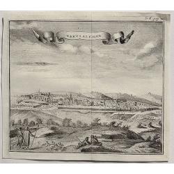
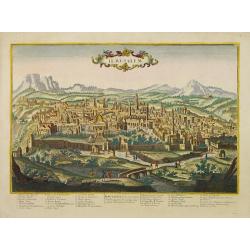
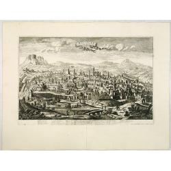
Gervsalemme.
A fine copper engraved bird’s eye view of Jerusalem by Salmon in 1738. It features a decorative ribbon cartouche. Thomas Salmon (1679–1767) was an English historical ...
Date: London, 1738
Selling price: ????
Please login to see price!
Sold in 2020
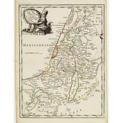
NORTH ISRAEL / MOUNT CARMEL.
A bird's eye view / map of the Holy Land from Haifa to Cesaria - Jerusalem centered on mount Carmel. Taken from the book: Conventuum fratrum Discalceatorum Ordinis B VIRG...
Date: Rome, 1739
Selling price: ????
Please login to see price!
Sold in 2017
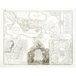
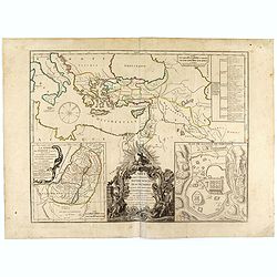
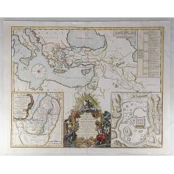
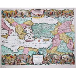
Regni Davidici et Salomonaei descriptio Geographica cum vicinis regionibus Syriae et Aegypti. . .
A rare map of the Near East region, extending from Turkey to Egypt. It includes Cyprus, Holy Land, and Mesopotamia, and illustrates the Kingdoms of David and Solomon. Myt...
Date: Nuremberg, ca 1739
Selling price: ????
Please login to see price!
Sold in 2020

Het Beloofde Landt Canaan door wandelt van onsen Salichmaecker Iesu Christo, neffens syne Apostelen
Dutch so-called Staten bibles, published between 1637 and c. 1760, contained 5 maps: The World, 'Paradise', The Perigrinations, The Promised Land Canaan, The Travels of S...
Date: Amsterdam, c. 1740
Selling price: ????
Please login to see price!
Sold
Iudae seu Terra Sancta quae Hebraeorum sive Israelitarum..
A dark impression with decorative cartouches.
Date: Amsterdam, 1740
Selling price: ????
Please login to see price!
Sold in 2009
Statt Ierusalem.
Jerusalem at the time of Christ. An imaginary plan, drawn after Adrichomius. Extensive title at top in Latin (L) and German (R): ‘Ierusalem, cum suburbiis, prout tempor...
Date: Augsburg, 1741
Selling price: ????
Please login to see price!
Sold in 2020
Novissima totius Terrae Sanctae sive promissionis. . .
Engraved by J.B.Homann and published by David Funck. One of the very few maps engraved by Johan Baptist Homann, signed lower right.A scarce map of the Holy Land, orientat...
Date: Nuremberg, 1742
Selling price: ????
Please login to see price!
Sold in 2021
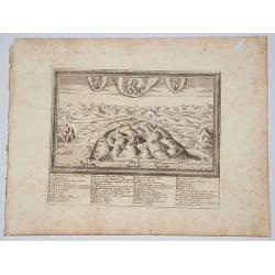
Overblyfselen der tuinen, en groote waterbakken van Salomon.
Fine copper engraving showing the contemporary remains of the Gardens and water reservoirs of Salomon. Engraved by A.D.Putter and taken from Bernard Picart's famous Cér�...
Date: Amsterdam 1743
Selling price: ????
Please login to see price!
Sold
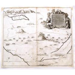
Carte du Voïage des Israëlites dans de desert..
Lièbaux's map of the Wandering of the Children Israel. With the route taken by the Israelites from Egypt to Canaan.
Date: Paris 1744
Selling price: ????
Please login to see price!
Sold
Judaea seu Palaestina .. Terra Sancta. . .
Johann Baptist Homann's well-engraved map has two large decorative cartouches. Upper left Moses receiving the Tables. Lower right Moses and Aaron pointing at a map showin...
Date: Nuremberg, 1744
Selling price: ????
Please login to see price!
Sold in 2021
Iudaea seu Palaestina .. Terra Sancta. . .
Johann Baptist Homann's well-engraved map has two large decorative cartouches. Upper left Moses receiving the Tables. Lower right Moses and Aaron pointing at a map showin...
Date: Nuremberg, 1744
Selling price: ????
Please login to see price!
Sold in 2011
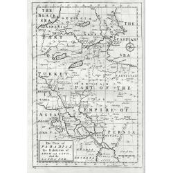
The Place Of Paradise The Habitation Of Adam And Seth And The Land Of Nod.
Mainly covers much of Georgia, Armenia, Turkey, Iran and Iraq and furthermore pointing out sites associated with Adams sons and charting the course that Noah's Ark took. ...
Date: London, 1744
Selling price: ????
Please login to see price!
Sold in 2017
Solomon Built the House of the lord on the Mount Where the Lord Appeared to David His Father. II Chronicle, Chapter III, Verse 1.
A fine religious print from a Bible in 1762. There are eight separate images including “The Temple of Solomon”, "The Tabernacle in the Wilderness", "Th...
Date: London, 1744
Selling price: ????
Please login to see price!
Sold in 2019
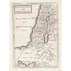
A map of the Holy Land and Syria.
Uncommon map of the Holy Land. With a key and decorative title cartouche in bottom. Published in Description of the East .
Date: London 1745
Selling price: ????
Please login to see price!
Sold
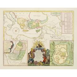
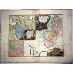
La Monarchie des Hebreux sous Salamon, ou le royaume D'Israel. . . / Carte de la terre des Hebreux ou Israelites. . .
Two maps of the Holy Land on one sheet representing the Monarchy of the Hebrews under Solomon divided into 12 governments. The Kingdom of Solomon includes not only Palest...
Date: Paris, 1745
Selling price: ????
Please login to see price!
Sold in 2011
Carte des voyages de Notre seigneur Jesus Christ..
Showing eastern part of the Mediterranean, including Cyprus, Italy. Lower right hand corner inset plan of Jerusalem. Lower left map of Palestine. Published by Vaugondy, a...
Date: Paris, 1747
Selling price: ????
Please login to see price!
Sold in 2009
Carte des voyages de Notre seigneur Jesus Christ. . .
Showing eastern part of the Mediterranean, including Cyprus, Italy. Lower right hand corner inset plan of Jerusalem. Lower left map of Palestine. Published by Vaugondy, a...
Date: Paris, 1747
Selling price: ????
Please login to see price!
Sold in 2011
Carte des voyages de Notre seigneur Jesus Christ. . .
Showing eastern part of the Mediterranean, including Cyprus, Italy. Lower right hand corner inset plan of Jerusalem. Lower left map of Palestine. Published by Vaugondy, a...
Date: Paris, 1747
Selling price: ????
Please login to see price!
Sold in 2022
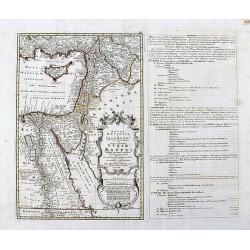
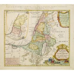
Terre de Chanaan ou terre promise à Abraham et à sa postérité ; Carte des voiages d'Abraham faits par l'ordre de Dieu, en Asie et en. . .
A large and rare copper engraved sheet with 2 maps of the Holy Land, or 'promised land to Abraham', includes also the route of Moses and the Israelites as they wandered t...
Date: Paris, ca 1747
Selling price: ????
Please login to see price!
Sold in 2021
Carte des Voyages de Notre Seigneur Jesus Christ. . .
A decorative map of the Eastern Mediterranean and contiguous regions, with a large inset plan of Jerusalem and inset map of Judea at the time of King Herod. The main map...
Date: Paris, 1747
Selling price: ????
Please login to see price!
Sold in 2019
Jerusalem
Great bird's eye plan of the holy city flanked by engravings of religious icons, and Solomon and a priest. At the top is a large elevation of the Temple of Solomon.
Date: Amsterdam, 1748
Selling price: ????
Please login to see price!
Sold in 2008
Pergrinatie ofte Veertich-iarige Reyse
Dutch Bible map of the Holy Land depicting the Exodus from Egypt and the wanderings of the Children of Israel. The lower part of the map is elaborately engraved with a sc...
Date: Amsterdam, 1741/1748
Selling price: ????
Please login to see price!
Sold in 2009
Afbeelding van ' T Land van Israel, naar deszelfs Natuurlijke gesteltheid.
Willem Albert Bachiene (1712-1783), Dutch geographer in Maastricht. Most important work ' Heilige Geographie', a work on the Holy Land.A map of Israel, embellished with t...
Date: Gorichem, Nicolaas Goetzee, 1748
Selling price: ????
Please login to see price!
Sold in 2020
Afbeelding van all de Landen gelegen tusschen de Middellandsche, Zwarte, Caspische, Persische en Rode Zeeën.
A map of the Near East. From a Dutch bible published by Nicolaas Goetzee. Prepared by Willem Albert Bachiene (1712-1783), Dutch geographer in Maastricht. Most important w...
Date: Gorichem, Nicolaas Goetzee, 1748
Selling price: ????
Please login to see price!
Sold in 2020
De Beyde Koningryken Juda en Israe¨l, die na Salomos dood zig van elkanderen afgescheurt hebben: benevens de Overheerde Landen . .
Bible map of the Kingdoms of Juda and Israel, with battle scene. Engraved by Jan van Jagen and published in a Dutch Bible by Nicolas Goetzee.Willem Albert Bachiene (1712-...
Date: Gorichem, Nicolaas Goetzee, 1748
Selling price: ????
Please login to see price!
Sold in 2016
Afbeelding van 't Koningryk Israels, Benevens de door 't zelve Overheerde Landen. . .
Bible map with impressive scene of 1 Kings 10:22 The king (Solomon) had a fleet of trading ships at sea along with the ships of Hiram. Once every three years it returned,...
Date: Gorichem, Nicolaas Goetzee, 1748
Selling price: ????
Please login to see price!
Sold in 2016
AFBEELDINGE DER OOSTERSCHE LANDEN waarin zoo de X stammen Israels als de II overige van Juda gedurende den tijd hunner ballingschap verkeert hebben. . .
Bible map with nice view of Arabia Felix. Engraved by Jan van Jagen and published in a Dutch Bible by Nicolas Goetzee.Willem Albert Bachiene (1712-1783), Dutch geographer...
Date: Gorichem, Nicolaas Goetzee, 1748
Selling price: ????
Please login to see price!
Sold in 2016
AFBEELDING VAN EGYPTE, DE WOESTIJNE DER SCHELFZEE EN 'T LAND KANAAN. . .
Bible map with exodus scene. Engraved by Jan van Jagen and published in a Dutch Bible by Nicolas Goetzee.Willem Albert Bachiene (1712-1783), Dutch geographer in Maastrich...
Date: Gorichem, Nicolaas Goetzee, 1748
Selling price: ????
Please login to see price!
Sold in 2016
AFBEELDINGE VAN 'T LAND KANAAN. . .
Map of Canaan engraved by Jan van Jagen and published in a Dutch Bible by Nicolas Goetzee.Willem Albert Bachiene (1712-1783), Dutch geographer in Maastricht. Most importa...
Date: Gorichem, Nicolaas Goetzee, 1748
Selling price: ????
Please login to see price!
Sold in 2016
AFBEELDINGE VAN 'T LAND VAN ISRAEL NAAR DESZELFS NATUURLIJKE GESTELD. . .
Map of the Land of Israel engraved by Jan van Jagen and published in a Dutch Bible by Nicolas Goetzee.Willem Albert Bachiene (1712-1783), Dutch geographer in Maastricht. ...
Date: Gorichem, Nicolaas Goetzee, 1748
Selling price: ????
Please login to see price!
Sold in 2016
'T LAND KANAAN benevens GILEAD.
Map of the Land of Canaan engraved by Jan van Jagen and published in a Dutch Bible by Nicolas Goetzee.Willem Albert Bachiene (1712-1783), Dutch geographer in Maastricht. ...
Date: Gorichem, Nicolaas Goetzee, 1748
Selling price: ????
Please login to see price!
Sold in 2016
Afbeelding van alle de landen gelegen tusschen de Middelandsche, Zwarte, Caspische, Persische en Rode Zeën.
Bible map with scene of Adam and Eve expulsed from paradise. Engraved by Jan van Jagen and published in a Dutch Bible by Nicolas Goetzee. Willem Albert Bachiene (1712-178...
Date: Gorichem, Nicolaas Goetzee, 1748
Selling price: ????
Please login to see price!
Sold in 2016
Afbeelding van all de Landen gelegen tusschen de Middellandsche, Zwarte, Caspische, Persische en Rode Zeën.
A map of the Near East, with an oversized Cyprus.Decorative, scrolled title cartouche to upper left corner. From a Dutch bible published by Nicolaas Goetzee. Willem Alber...
Date: Gorichem, Nicolaas Goetzee, 1748
Selling price: ????
Please login to see price!
Sold in 2020
Das Gelobte LandSsammt der 40 Jærigen Reise de Kinder Israel aus Egypten.
A pleasant map of the Holy Land by George Schrieber. Published in the 'Atlas Selectus', orientated with north to the right. With decorative cartouches for title and key f...
Date: Leipzeg, 1749
Selling price: ????
Please login to see price!
Sold in 2021
't Land Kanaan..
This map depicts Palestine divided into the twelve tribes. It is finely engraved and shows towns, villages and rivers. Decorated with a title cartouche, a bible scene and...
Date: Amsterdam 1750
Selling price: ????
Please login to see price!
Sold
TERRE de CANAAN à présent la PALESTINE.
Uncommon map of the Holy Land oriented to the west.
Date: France, c.1750
Selling price: ????
Please login to see price!
Sold
De Gelegentheyt van t' Paradys en t' Landt Canaan, mitsgaders d' eerst bewoonde Landen der Patriarchen.
Dutch so-called "Staten" bibles, published between 1637 and c. 1760, contained 5 maps: The World, "Paradise", The Perigrinations, The Promised Land Ca...
Date: Amsterdam / Dordrecht, Pieter Keur, Pieter Rotterdam em Pieter Rotterd, 1750
Selling price: ????
Please login to see price!
Sold
De Beschryving van de Reysen Pauli en Van de Andere Apostelen.
The Dutch so-called ' Staten' bibles published between 1637 and c. 1760, contained 5 maps: The World, ' Paradise', The Perigrinations, The Promised Land Canaan, The Trave...
Date: Amsterdam / Dordrecht, Pieter Keur, Pieter Rotterdam en Pieter Rotterd, 1750
Selling price: ????
Please login to see price!
Sold
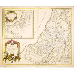
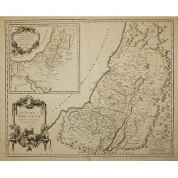
La Judée ou Terre Sainte divisé en sous..
A finely engraved and uncommon map depicting the division of the Holy Land into twelve tribes. In upper left hand corner inset map of land of Canaan. Decorative title car...
Date: Paris 1750
Selling price: ????
Please login to see price!
Sold in 2008
La monarchie des hébreux sous Salomon, ou le royaume d'Israël distingué en douze préfectures ou gouvernements / par le Sr. Moullart-Sanson. . .
Scarce map of Kingdom of Israel. Published by Pierre Moullart-Sanson, who was the grandson of Nicolas the elder.Very decorative title cartouche. On the upper left corner,...
Date: Paris, ca. 1750
Selling price: ????
Please login to see price!
Sold in 2015
Les Voiages de notre Seigneur Jesus Christ et des ..
Scarce map of the travels of Jesus, St Peter and St Paul. Published by Pierre Moullart-Sanson, who was the grandson of Nicolas the elder. Engraved by De la Haye.Very deco...
Date: Paris, ca. 1750
Selling price: ????
Please login to see price!
Sold in 2019
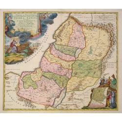
La Judée ou Terre Sainte divisée en ses douze tribes.
A finely engraved and uncommon map depicting the division of the Holy Land into twelve tribes. In upper left hand corner inset map of land of Canaan. Decorative title car...
Date: Paris, 1750
Selling price: ????
Please login to see price!
Sold
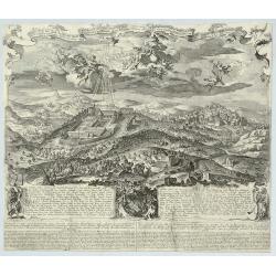
Ierusalem.
A rare and beautifully engraved and richly detailed panoramic view of Jerusalem. With in lower part numbered key (1-36) with description of most important buildings of Je...
Date: France, ca. 1750
Selling price: ????
Please login to see price!
Sold in 2008
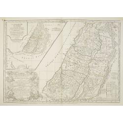
Palaestina in XII. Tribus divisa. . .
Uncommon map of the Holy Land, colored according to the lands of the 12 tribes.Including northern part of Egypt. Prepared by Johannes Christoph Harenberg. With two very l...
Date: Nuremberg, 1750
Selling price: ????
Please login to see price!
Sold in 2023
Afbeeldinge der stad Jerusalem..
Great bird's eye plan of the holy city.
Date: Gorinchem, 1750
Selling price: ????
Please login to see price!
Sold in 2008
Afbeelding van 'T Joodsche Land..
This attractive map from a large Dutch Bible shows the land of Israel with all the places, rivers, mountains, and seas mentioned in the Holy Scriptures. It covers all of ...
Date: Gorinchem, 1750
Selling price: ????
Please login to see price!
Sold in 2009
Jerusalem comme elle est a present.
A very decorative and extremely rare of Jerusalem, including a numbered (1-36) key in lower part. Published by Jacques Chéreau, (1688 - 1776). Engraved by Aveline and f...
Date: Paris, ca.1750
Selling price: ????
Please login to see price!
Sold in 2013
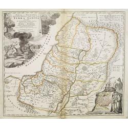
La Judée ou Terre Sainte divisé en ses douze Tribus, ...
A finely engraved and uncommon map depicting the division of the Holy Land into twelve tribes. In upper left hand corner inset map of land of Canaan. Decorative title car...
Date: Paris, 1750
Selling price: ????
Please login to see price!
Sold in 2011
Ierusalem.
A rare, beautifully engraved and richly detailed panoramic view of Jerusalem. Numbered key (1-36) on the lower part with description of most important buildings of Jerusa...
Date: France, c.1750
Selling price: ????
Please login to see price!
Sold in 2011
La Judee ou Terre Sainte Divisee en ses Douze Tribus.
Beautiful 1750 map of Israel, Palestine or the Holy Land by Robert de Vaugondy. It extends from Sidon to Gaza and Covers the region as it existed in Biblical times with d...
Date: Paris , 1750
Selling price: ????
Please login to see price!
Sold in 2017
![[Lot of 4 maps] Afbeeldinge der Oostersche Landen. / van ' T Land Kanaan.](/uploads/cache/100146-250x250.jpg)
[Lot of 4 maps] Afbeeldinge der Oostersche Landen. / van ' T Land Kanaan.
Willem Albert Bachiene (1712-1783), Dutch geographer in Maastricht. Most important work ' Heilige Geographie', a work on the Holy Land. A map of the Near East and a map o...
Date: Amsterdam, c. 1750
Selling price: ????
Please login to see price!
Sold in 2022
Palaestina S.EU Terra Sancta.
Map of Palaestina by Christoph Cellarius, from "Geographia Antiqua". Highly detailed map of the area.
Date: Leipzig, 1755
Selling price: ????
Please login to see price!
Sold in 2012
Waher Abriss der Stadt Bethlehem. . .
A magnificent panoramic view of the city of Bethlehem described as "true" and "accurate" based on the work of monk of the Strasbourg Province of the F...
Date: Augsburg, 1755
Selling price: ????
Please login to see price!
Sold in 2019
La Palestine ou la Terre Sainte divisée en dix Tribus..
Fine map of Palestine with ten tribal territories outlined in color. A helmeted female figure holds the garlanded title cartouche.George Louis Le Rouge was active from 17...
Date: Paris 1756
Selling price: ????
Please login to see price!
Sold
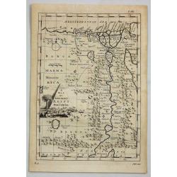
A Map of Ancient Aegypt from Celarius.
A fine map of Ancient Egypt with its cities and topography. There is a decorative title cartouche in the shape of a pyramid, surrounded by ancient Egyptian antiquities su...
Date: London, 1756
Selling price: ????
Please login to see price!
Sold in 2021
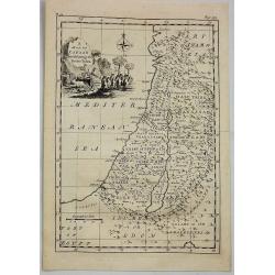
A Map of Canaan Divided Among the Twelve Tribes.
An Old Testament Israel showing its twelve divisions according to the tribes. With a decorative title cartouche depicting the Ark of the Covenant, various temple tools an...
Date: London, 1756
Selling price: ????
Please login to see price!
Sold in 2019
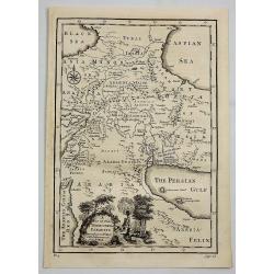
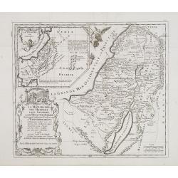
A Map of the Terrestrial Paradise According to Mr. Huet with Improvements from Dr. Wells.
A map of the Ancient Near East, showing ancient cities, kingdoms, and pinpointing the site of the Garden of Eden. With a decorative title cartouche featuring Eden and Ada...
Date: London, 1756
Selling price: ????
Please login to see price!
Sold in 2020
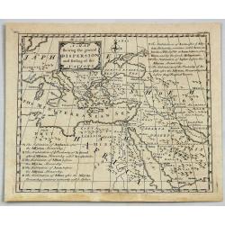
A Map Shewing the General Dispersion and Settling of the Nations.
A fine map of The Eastern Mediterranean, Arabia and part of North Africa, illustrating the area that was settled by the three sons of Noah (Sem, Ham & Japeth) after t...
Date: London, 1756
Selling price: ????
Please login to see price!
Sold in 2021
