Browse Listings in America > North America > North Pole
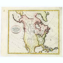
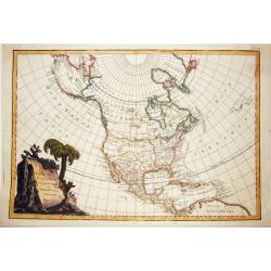
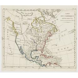
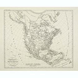
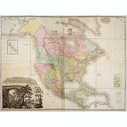
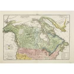
A New and Accurate Map of North America from the best Authorities.
A scarce map of North America, from Brown's 'General Atlas', engraved by Menzies. It shows a 'River of the West', extending from the Juan De Fuca entrance to the R. Orega...
Place & Date: Edinburgh, 1792
Selling price: $205
Sold in 2020
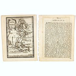
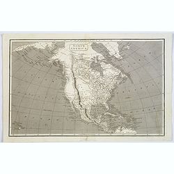
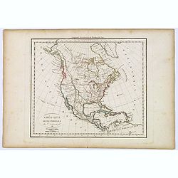
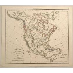
North America.
Uncommon miniature map from Gibson's "Atlas Minimus, or a New Set of Pocket Maps of the several Empires, Kingdoms and States of the known World". Together with ...
Place & Date: London, 1792
Selling price: $75
Sold in 2017
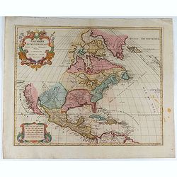
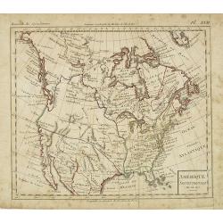
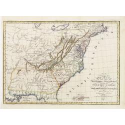
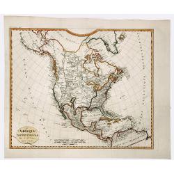
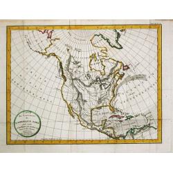
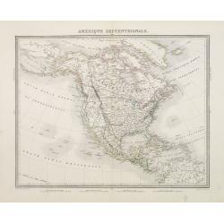
Amerique Septentrionale . . .
Richly embellished map of North America. Based on the Sanson map, which was the first to include all five Great Lakes. California now attached to the mainland. With a lar...
Place & Date: Amsterdam, 1792
Selling price: $400
Sold in 2020
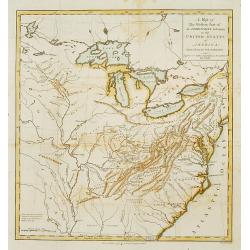
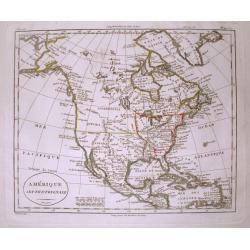
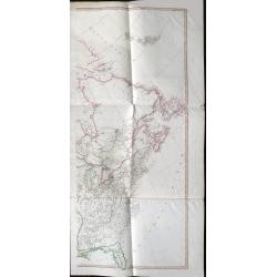
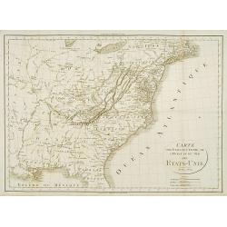
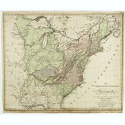
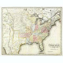
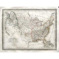
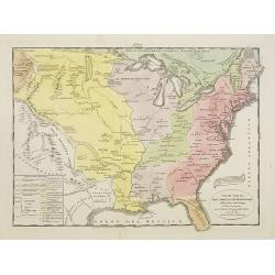
Western Part of the Territories.
A Map of the western part of the territories belonging to the United States of America. Engraved for Imlay's Topographical Description of that Country . Engraved by T. Co...
Place & Date: London 1793
Selling price: $410
Sold
RUSSIAN TEXT MAP - NORTH AMERICA.
A rare Russian, copper engraved map of north America. Based on the second state of the Janvier/Lattre map. It includes the results of Captain Cooks discoveries on America...
Place & Date: St.Petersburg, 1793
Selling price: $750
Sold in 2021
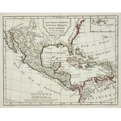
Nouvelle Espagne, Nouvaeu Mexique, Isles Antiles.
Published by Charles Lamarche. Showing the most notable areas of New Spain in North, South and Central America from Nouveau Mexique to Terre Ferme as well as the Caribbea...
Place & Date: Paris, 1794
Selling price: $75
Sold in 2011
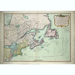
A new and correct map of the British Colonies in North America. . .
Famous map prepared by Gov. Pownall Major Holland. Northern British Colonies, Quebec, New Foundland, Nova Scotia, New England, New York. Including Hudson and James Bays, ...
Place & Date: London, 1794
Selling price: $475
Sold in 2013
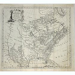
A new map of North America agreeable to the most approved maps and charts. . .
Detailed and uncommon map of North America with the Northwest labeled These Parts Are Entirely Unknown and Land discovered by de L'Isle 1741. Engraved by T.Condor and pub...
Place & Date: London, 1794
Selling price: $300
Sold in 2013
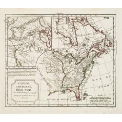
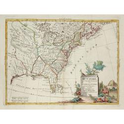
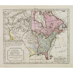
Canada, Louisiane, États-Unis. Par Robert de Vaugondy Géographé, Corrigés par le C.en Lamarche son Successeur. L'An 3.em de la République Franc?.
Two maps on one sheet. The map of the western part of North America is most notable for it's depiction of "Mer de L'Ouest" or "Sea of the West".A grea...
Place & Date: Paris, 1795
Selling price: $170
Sold in 2016
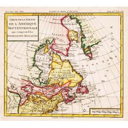
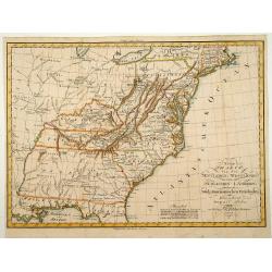
Carte de la Partie de l'Amerique Septentrionale, comprenant les Possessions Anglaises.
Louis Brion de la Tour (1756-1823), French geographer. ' Atlas Géneral, Civil et Ecclésiastique', 1766, ' Atlas Général', 1790-98. From Brunet's 'Histoire Universelle...
Place & Date: Paris, c. 1795
Selling price: $190
Sold

Sauvage Iroquois.
Hand-colored mezzotints of Native Americans drawn by Labrousse and engraved by Laroque after Jacques Grasset de Saint-Sauveur.
Place & Date: Paris,1796
Selling price: $35
Sold in 2011

Jongleur Iroquois.
Hand-colored mezzotints of Native Americans drawn by Labrousse and engraved by Laroque after Jacques Grasset de Saint-Sauveur.
Place & Date: Paris,1796
Selling price: $25
Sold in 2011
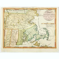
A map of Massachusetts from the best Authorities by J.Denison.
The map highlights Martha's Vineyard and Nantucket Island. The "Proposed Canal" is located near Sandwich. Beneath the oval title cartouche and distance scale is...
Place & Date: Boston, 1796
Selling price: $200
Sold in 2021
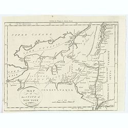
Map of the State of New York.
A nice post revolutionary war map of the state of New York by James Denison, published in Boston by Thomas and Andrews. Map shows rivers, mountains, roads, state boundari...
Place & Date: Boston, 1796
Selling price: $30
Sold in 2019
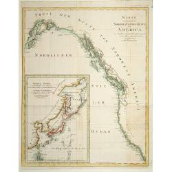
Karte von .. Norstwestlichen Kuste America.
A very nice map centered on Northwest coast of America, including the city of Vancouver. On the lower left corner, an inset map (285x208 cm) of Japan, Taiwan and Chinese ...
Place & Date: Berlin 1800
Selling price: $510
Sold
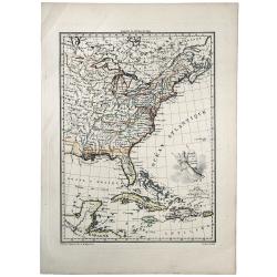
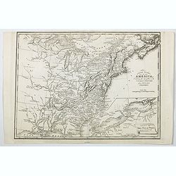
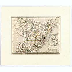
Part of the United States of North America.
Fine map of the eastern part of the United States, with in lower right an inset of South Carolina. An entirely new engraving, closely copied from the 1798 English edition...
Place & Date: Berlin 1800
Selling price: $250
Sold
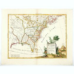
Il Canada le Colonie Inglesi con Luigiana e Florida . . .
Map of East coast of America including the Great Lakes. Fine title cartouche lower right hand corner. From Zatta's Atlante Novissimo.
Place & Date: Venise, 1800
Selling price: $240
Sold in 2010
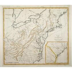
Theil der Vereinigten Staten von Nord America.
Detailed map of eastern part of the United States. In lower right hand corner inset map of Georgia, North and South Carolina.Showing routes of Mr. Weld.
Place & Date: Germany, c.1800
Selling price: $900
Sold in 2012
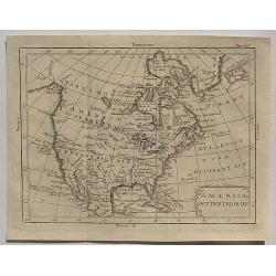
Amerique Septentrionale.
Interesting map of North America, where the Mississippi River serves as the western boundary of the United States, with the western frontier under Spanish rule. Several s...
Place & Date: Paris, c1800
Selling price: $130
Sold in 2014
North America.
John Arrowsmith's map of North America at the turn of the nineteenth century. It shows very little exploration west of the Mississippi River, and 'Louisiana' stretches fr...
Place & Date: London, ca. 1800
Selling price: $45
Sold in 2017
America Settentrionale.
An interesting rare copper engraved map of North America by an unknown cartographer in about 1800. Text in Italian. The cartouche is quite plain but it does have minimal ...
Place & Date: Spain, ca 1800
Selling price: $95
Sold in 2020
Il Canada le Colonie Inglesi con Luigiana e Florida. . .
A splendid map of the east coast of America including the Great Lakes. With a decorative and fine title cartouche lower right hand corner, and mileage scales. From Zatta'...
Place & Date: Venice, 1800
Selling price: $350
Sold in 2020
A Map Exhibiting all the New Discoveries in the Interior Parts of North America...
Published between 1795 and 1824, Aaron Arrowsmith's map of North America, is perhaps the single most important maps of North America after the American Revolution. It rep...
Place & Date: London, 1802
Selling price: $1400
Sold in 2020
Amérique Septentrionale an XI 1803.
Curious map of North America taken from "Boussole des speculateurs". According to the title, an uncommon encyclopedical work should be useful for investors and ...
Place & Date: Paris, 1803
Selling price: $160
Sold in 2012
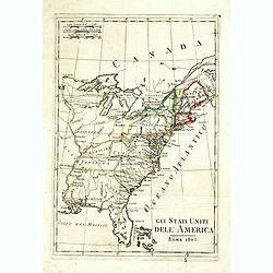
Gli Stati Uniti dell'America.
A rare map of the United States of America, from "Nuova geografia universale antica e moderna cosmografica, fisica, topografica, di commercio e d'industria politica,...
Place & Date: Rome, Vincenzo Poggioli, 1803
Selling price: $200
Sold in 2020
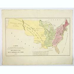
ETATS UNIS DE L' AMERIQUE.
A scarce early, original outline colored map of the United States, showing 17 organised states. Georgia still extends to the Mississippi River, shortly before the organis...
Place & Date: Paris, 1803
Selling price: $40
Sold in 2019
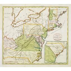
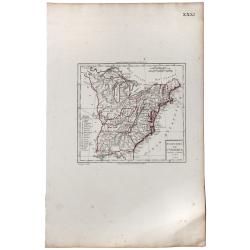
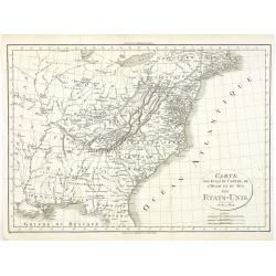
Carte des Etats du centre, de L'Quest et du Sud des Etats-Unis.
Detailed map of the East Coast of America. Engraved by S.Glot.
Place & Date: Paris, ca. 1804
Selling price: $200
Sold
![[no title] Map of the United States and southern Canada.](/uploads/cache/44308-250x250.jpg)
[no title] Map of the United States and southern Canada.
This untitled map of the United States and southern Canada bears the imprimatur Smith & Jones Sculp. 13 Pleasant Row Pentonville (McCorkle #799.8). It is from an Engl...
Place & Date: London, R.Philips, 1804
Selling price: $1000
Sold in 2020
Neue Charte von dem Mittleren Westlichen .. Nord Amerika..
A very nice map centered on north America, including part of Florida, north and south Carolina, Pennsylvania, etc. Title cartouche on the lower right corner.
Place & Date: Weimar 1805
Selling price: $410
Sold
Neue Charte von den Mittleren, Westlichen und Südlichen Ländern der Nord-Americanischen Freistaaten..
A detailed and rare map covering good part of the central and eastern American States.
Place & Date: Weimar 1805
Selling price: $220
Sold
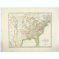
Carte de l'Amérique Septentrionale Divisée en ses principaux Etats.
Map of North and Central America. From Atlas de la Géographie de toutes les parties du monde .. Ouvrage destiné pour l'education, et nécessaire aux négocians, aux voy...
Place & Date: Paris, Prudhomme, Levrault, Debray, 1806
Selling price: $48
Sold in 2023
Canada, Louisiane, États-Unis.
Although dated 1794/95 [l'An 3e.], the map is a copy of an earlier map which appeared in Robert de Vaugondy''s 1778 atlas. Two maps on one sheet. The map of the western p...
Place & Date: Paris, 1794 - 1806
Selling price: $210
Sold in 2016
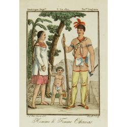
Homme & Femme Ottawas.
Hand-colored mezzotints of Native Americans engraved by Félix Mixelle and Lachaussée Jeune after Jacques Grasset de Saint-Sauveur.
Place & Date: Paris,1801-1806
Selling price: $30
Sold in 2011

Homme & Femme Iroquoia.
Hand-colored mezzotints of Native Americans engraved by Félix Mixelle and Lachaussée Jeune after Jacques Grasset de Saint-Sauveur.
Place & Date: Paris,1801-1806
Selling price: $50
Sold in 2011

Homme & Femme de Népissens.
Hand-colored mezzotints of Native Americans engraved by Félix Mixelle and Lachaussée Jeune after Jacques Grasset de Saint-Sauveur.
Place & Date: Paris,1801-1806
Selling price: $50
Sold in 2011
Carte des Etats du centre, de L'Quest et du Sud des Etats-Unis.
Detailed map of the East Coast of America, taken from "Voyage à l'Ouest des Monts Alléghanys, dans les Etats de l'Ohio, du Kentucky et du Tennessée, et retour à ...
Place & Date: Paris, Dentu, 1808
Selling price: $400
Sold in 2015
Amérique Septentrionale.
A charming map of North America. Very detailed. Published by Alexandre Emile Lapie, in his atlas Universel. Engraved by Tardieu.
Place & Date: Paris 1809
Selling price: $140
Sold
Amerique Septentrionale. . .
Detailed map of the United States and Canada giving good detail along the east coast and the Lakes. Including Port St.Francois, Monterey, Pte. De Pins, Pt.Estero, Pte de ...
Place & Date: Paris, 1809
Selling price: $120
Sold in 2011
AMERIQUE SEPTENTRIONALE.
A detailed map of North America, issued shortly before the publication of the official account of Lewis & Clark's expedition to the Pacific Ocean. The map shows a ver...
Place & Date: Paris, 1809
Selling price: $110
Sold in 2019
Amérique septentrionale.
A fine map of North America published by the well-known Paris publisher of maps, globes and atlases C.F. Delamarche.
Place & Date: Paris, 1811
Selling price: $50
Sold in 2017
Die Vereinigten Staaten von Nordamerika nach Arrowsmith und Lewis Karten vom Jahre 1795 und 1796. . .
A uncommon map of the United States, according to the title based on the maps by Arrowsmith and Lewis published in 1795 and 1796. Roads and Indian tribes are noted, in ad...
Place & Date: Nuremberg, 1812
Selling price: $850
Sold in 2016
ETATS UNIS ET GRANDES ANTILLES.
An attractive map of the United States and West Indies with decorative cartouche, from 'Atlas Supplementaire du Precis de la Geographie Universalle de M. Malte-Brun by La...
Place & Date: Paris, 1812
Selling price: $41
Sold in 2019
A Map exhibiting the frontiers of Canada and the United States, intended to illustrate the operations of the British & American armies
A scarce map issued during the War of 1812. Large inset lower right, "A sketch of the coast of North America; from the River St. Lawrence, to Chesapeake Bay." S...
Place & Date: London, 1813
Selling price: $4800
Sold in 2015
United States of America, Exhibiting the Seat of War on the Canadian Frontier from 1812 to 1815.
Edward Baines' 1816 map of the 'United States of America, Exhibiting the Seat of War on the Canadian Frontier from 1812 to 1815' A scarce of the US, published after the W...
Place & Date: Leeds, 1816
Selling price: $215
Sold in 2021
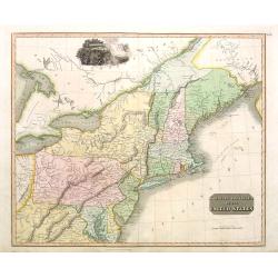
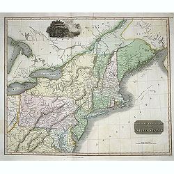
Northern Provinces of the United States.
Somewhat later but very finely engraved and detailed map of the United States.
Place & Date: Edinburgh, 1817
Selling price: $450
Sold in 2008
Nothern Provinces of the United States
Somewhat later but very finely engraved and detailed map of eastern part of the United States. Including the states and territories of New England, New York, Pennsylvania...
Place & Date: Edinburgh, 1817
Selling price: $111
Sold in 2013
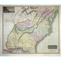
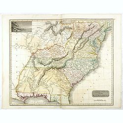
Southern Provinces of the United States
Somewhat later but very finely engraved and detailed map of the United States. Including the states and territories east of the Mississippi River to the Atlantic and as f...
Place & Date: Edinburgh, 1817
Selling price: $250
Sold in 2013

George Washington.
Rare lithographed portrait of George Washington, by an unknown artist; published by William Smith, 702 So. Third St, Philadelphia.Surrounded by scroll work.
Place & Date: Philadelphia, c1820
Selling price: $100
Sold in 2016
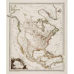
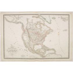
Carte du Continent de l\' Amerique Nord.
A map of North America.
Place & Date: Paris, 1821
Selling price: $250
Sold in 2013
Carte Physique et Politique de l'Amérique Septentrionale. . .
Huge map of North America and the Caribbean showing the political divisions and colonial possessions with a color key at bottom. Brué prepared the maps for Louis de Onis...
Place & Date: Paris, 1821
Selling price: $500
Sold in 2016
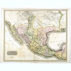
Spanish North America.
The excellent map by the Scottish engraver John Thomson, depicts Mexico from the Yucatan northwards to what would eventually become the Republic of Texas, and the Louisia...
Place & Date: Edinburgh, 1821
Selling price: $500
Sold in 2016
Southern Provinces of the United States.
A very finely engraved and detailed map of United State, that Includes the states and territories east of the Mississippi River to the Atlantic and as far north as Lake E...
Place & Date: Edinburgh, 1821
Selling price: $220
Sold in 2018
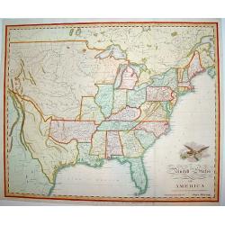
United States of America Compiled from the latest and best..
An uncommon and important map by the well recognized American cartographer John Melish, engraved by Samuel Harrison. Melish was the first American publisher to issue excl...
Place & Date: Philadelphia, 1822
Selling price: $1300
Sold
Map of the United States with contiguous British & Spanish Possessions.
.. compiled from the latest & best authorities by John Melish. Engraved by J. Vallance and [H.S.] Tanner. Entered according to Act of Congress the 16.th day of June 1...
Place & Date: Philadelphia, 1822
Selling price: $30025
Sold
United States of America.
An uncommon and important map by the well recognized American cartographer John Melish. Shows both the newly formed state of Missouri and the massive Missouri Territory.M...
Place & Date: Philadelphia, H.C. Carey & I. Lea, 1822
Selling price: $1100
Sold in 2019
United States.
A small map of the east and south east of the United States. From Louisiana , up to the 'Northwest Territory' and across to New England and down to Florida. There is an i...
Place & Date: London, 1822
Selling price: $29
Sold in 2019
Amérique septentrionale.
A fine map of North America published by the well-known Paris publisher of maps, globes and atlases.The map includes "Mormonfort" next to Lac Salé. Mormons arr...
Place & Date: Paris, 1824
Selling price: $120
Sold in 2023

Freistaat von Nordamerica. . .
Scarce and unusual German map featuring primarily topography. Twenty-nine states and territories are outlined and named in a panel at bottom. A huge Louisiana stretches t...
Place & Date: Berlin, 1824
Selling price: $200
Sold in 2016
Carte Générale des Etats Unis de L''Amérique Septentrionale..
Detailed map of the United States. Prepared by L.Vivien and engraved in steel by Giraldon-Bovinet.Published by Menard and Desenne, rue Git-le-Ceur 8, Paris.
Place & Date: Paris, 1825
Selling price: $250
Sold in 2015
Carte Générale des Etats Unis de L'Amérique Septentrionale. . .
A highly interesting map of much of today's USA, the Bahamas, and parts of Canada. The map features the 54° 40' or Fight border with the huge Northwest region extending ...
Place & Date: Paris, 1825
Selling price: $95
Sold in 2018
![North America [2 maps].](/uploads/cache/42445-250x250.jpg)
North America [2 maps].
A differing pair of North American maps, both published in 1820s, one in London, the other in Edinburgh. The map published by Constable, after Arrowsmith shows N. America...
Place & Date: London, Edinburgh 1820 -1825
Selling price: $150
Sold in 2020
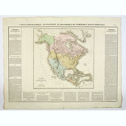
Carte Géographique, Statistique et Historique L'Amerique Septentrionale.
A lovely detailed map of North America, from Buchon's, Atlas Gégraphique Statistique, historique et chronologique des deux Ameriques et des isles adjacentes: traduit de ...
Place & Date: Paris, 1825
Selling price: $50
Sold in 2019
Etats-Unis d'Amerique.
A nicely detailed map of the U.S.A., showing the various states with their political borders, in fine original colors. This interesting map shows the Oregon Territory, th...
Place & Date: Paris, 1825
Selling price: $105
Sold in 2019
Carte de l'Adjonction Progressive des divers Etats au Territoire et a l'Union Constitutionnelle des Etats-Unis de l'Amerique du Nord. 1825.
An interesting map of the United States from Buchon's Atlas Gégraphique Statistique, historique et chronologique des deux Ameriques et des isles adjacentes, traduit de l...
Place & Date: Paris, 1825
Selling price: $60
Sold in 2019
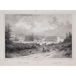
Bains de Saratoga / Saratoga Bath
From Jacques Gerard Milbert's Itineraire pittoresque du Fleuve Hudson et des parties laterales de l'Amerique du Nord.
Place & Date: Paris, c.1826
Selling price: $40
Sold in 2010
Carte Generale Des Etats-Unis De L'Amerique avec les Plans des principales Villes...
Highly detailed coast-to-coast map of the United States, published by Eustache Herrison in Paris, engraved by J.B. Tardieu, with inset plans of Washington, Boston, Philad...
Place & Date: Paris, Jean, 1826
Selling price: $650
Sold in 2020

John Adams.
Lithographed portrait of John Adams, by Ch. Motte after Mauraisse. Dated and signed by Mauraisse lower left part.Seal carrying the Initials Q.M. and the lettering Contemp...
Place & Date: Paris 1827
Selling price: $120
Sold
Amérique septentrionale..
General map of north America.
Place & Date: Paris 1828
Selling price: $22
Sold
Amérique Septentrionale . . .
Detailed map of North America, prepared by A. H. Basset, rue Saint-Jacques, no. 64, Paris and published in Atlas classique et Universel de Géographie . . . .The engraver...
Place & Date: Paris, A.H. Basset, 1828
Selling price: $70
Sold in 2022
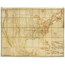
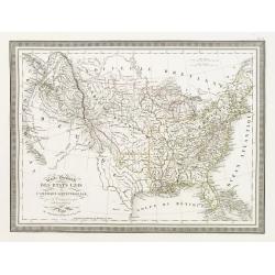
A Map of North America, Constructed According To The Latest Information ... Improved to 1828.
It says in the title : "improved to 1828". This milestone map was first issued issued separately in 1822 and also bound in four sheets into Tanner's "New ...
Place & Date: Philadelphia, Henry Tanner, after 1828
Selling price: $7800
Sold in 2013
Amerique Septentrionale.
A fine map of North America published by the well-known Paris publisher of maps, globes and atlases C.F. Delamarche.C.F. Delamarche (1740-1817) was a French geographer an...
Place & Date: Paris, 1828
Selling price: $130
Sold in 2019
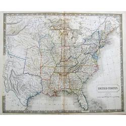
United States.
"Uncommon detailed steel engraved map of the United States. Published in Edinburgh by Daniel Lizars. A detailed showing the states and territories from Missouri east...
Place & Date: Edinburgh 1833
Selling price: $350
Sold
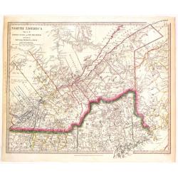
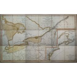
North America (Sheet II) Lower Canada and New Brunswick with a Part of New York, Vermont and Maine.
Very detailed sectional map of North America published by Baldwin & Cradock under the superintendence of the Society for the Diffusion of Useful Knowledge in London i...
Place & Date: London, 1833
Selling price: $125
Sold in 2015
America Settentrionale..
Rare and detailed map of the northern part of the United States of America and Canada, including Alaska, engraved by Marco Zuliani. According to the title cartouche, prep...
Place & Date: Venice, 1835
Selling price: $96
Sold in 2011
Stati-Uniti Dell'America settentrionale. . .
Rare and detailed map of eastern part of the United States of America, including Great Lakes, Florida, engraved by Marco Zuliani. According to the title cartouche, prepar...
Place & Date: Venice, 1835
Selling price: $250
Sold in 2011
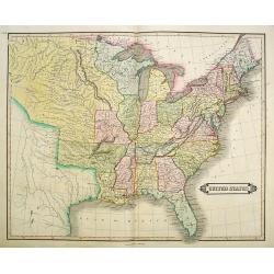
United States.
A detailed map of the United States shown until Texas and the Western Territory. Shows a large area labeled Nebraska.Includes some of the first railroads along the East C...
Place & Date: London, ca. 1835
Selling price: $120
Sold in 2017
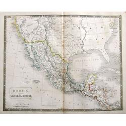
Mexico. And Central States Corrected from original information communicated by Simon A.G. Bourne Esq.
An important map of the South-West US, with Texas and Upper, or New California. With excellent detail throughout Mexico and until Costa Rica.Mines in Mexico are noted by ...
Place & Date: London, ca. 1835
Selling price: $37
Sold in 2018
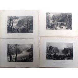
Four Bartlett steel Engravings - North American Rivers.
Four fine steel engraving prints by William Bartlett. Included are:- The Banks of the River Niagara- Bridge Near Quebec- The Outlet of Niagara River - Wolf's CoveWilliam ...
Place & Date: London, 1836
Selling price: $11
Sold in 2016
Amérique Septentrionale.
Fine map of North America.From Malte-Brun's Atlas Géographie Universelle.."., revised by Jean Jacques Nicolas Huot.This very fine executed map has been printed by F...
Place & Date: Paris, 1837
Selling price: $50
Sold in 2011
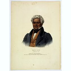
Major Ridge. A Cherokee Chief.
Head and shoulders portrait of Major Ridge,(1771-1839) wearing a blue jacket, gold or yellow vest, white shirt, and black cravat. A Cherokee Chief, who as a Cherokee lead...
Place & Date: Philadelphia, 1837
Selling price: $185
Sold in 2017