Browse Listings in America > North America > North Pole
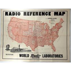
Radio Reference Map.
An interesting advertising map for 'WORLD RADIO LABORATORIES', “The World’s Largest Distributors of Amateur Radio transmitting Equipment”. It shows the monitoring s...
Place & Date: Council Bluffs, 1947
Selling price: $140
Sold in 2018
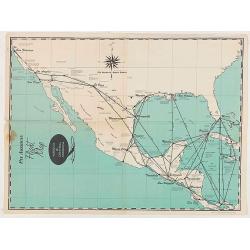
Pan American Flight Map - Mexico & Central America.
Pan American Airlines Flight Map of Mexico & Central America from the mid 1950's.
Place & Date: United States, ca 1950
Selling price: $60
Sold in 2020
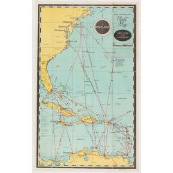
Pan American Flight Map - Mexico & Central America.
Pan American Airlines Flight Map of Mexico & Central America from the mid 1950's.
Place & Date: United States, ca 1950
Selling price: $50
Sold in 2020
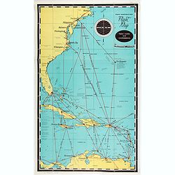
Pan American Airways New York - Caribbean.
Pan American Airlines Flight Map of New York to Caribbean from the mid 1950's.
Place & Date: United States, ca. 1950
Selling price: $50
Sold in 2021
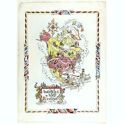
Amérique du Nord et Centrale.
color printed pictorial map of North and Central America, with decorative title cartouche and borders, depict countries, regions, major cities, industries, agriculture, I...
Place & Date: Paris, 1951
Selling price: $110
Sold in 2018
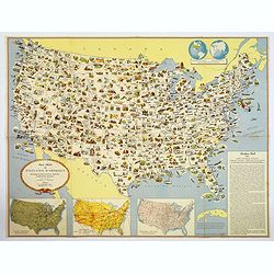
Carte Illustree des Etats-Unis d'Amerique Principaux produits, resources regionales, et particularites physiques.
A decorative French map of the United States' main products, regional resources and physical features. The map is covered with many small pictorial vignettes highlighting...
Place & Date: Washington D.C., ca. 1965
Selling price: $55
Sold in 2018

Ronald Reagan.
Original drawing representing a caricature of Ronald Reagan.Born in 1958, Jan Op De Beeck was elected in 2003 as 'World's Best Caricaturist' by the Professional cartoonis...
Place & Date: Belgium, 1987
Selling price: $200
Sold
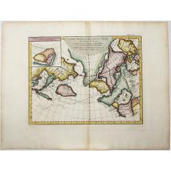
Carte Generale des Decouvertes de l'Amiral de Fonte, . . (Explorers)
An interesting map of the NW Coast of America and the NE Coast of Asia, based upon Jefferys map of 1768. Prior to Cook's 1st Voyage, the English, French and Russians were...
Place & Date: Paris, 1770ca
Selling price: $106
Sold in 2020
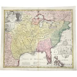
Amplissimae Regionis MISSISSIPI Seu Proninciae Ludovicianae.
A striking hand-colored example of Homann's map of the Course of the Mississippi River, based upon the reports of Hennepin, who explored the upper Mississippi and Great L...
Place & Date: Nuremberg, ca 1720
Selling price: $1000
Sold in 2019
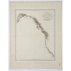
Carte de la partie de la Cote nord-ouest de l' Amerique.
A detailed and rare map of the Gulf of Alaska, British Columbia, and south to St.Francisco. Prepared by Edward Roberts after information by George Vancouver and engraved ...
Place & Date: Paris, ca. 1800
Selling price: $180
Sold in 2017
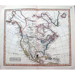
North America.
An interesting steel engraved map showing Mexico reaching until Mendocino and Utah Lake! Locates Texas, Cabo San Lucas, New Madrid in Missouri, etc. Names Indian nations,...
Place & Date: Anon, ca 1820?
Selling price: $47
Sold in 2018
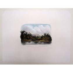
Washinga Sahba's Grab.../ Tombeau de Wachinga Sahba.../ Washinga Sahba's Grave on Blackbird's Hill.
Aquatint from: 'Reise in das innere Nord-America in den Jahren 1832-1834' by Prince Maximilian of Wied-Neuwied, after paintings by Karl Bodmer, engraved by Lucas Weber, p...
Place & Date: London, 1842
Selling price: $200
Sold in 2016