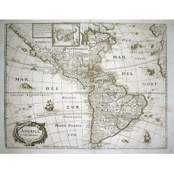
Browse Listings in America
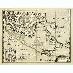
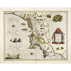
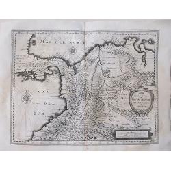
Freti Magellanici ac novi Freti vulgo Le Maire. . .
Early impression of this fine map of Tierra del Fuego. Hondius added a Dutch translation of the explanatory text of the passage by Barent Jansz. Potgieter who accompanied...
Date: Amsterdam, 1635
Selling price: ????
Please login to see price!
Sold in 2012
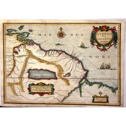
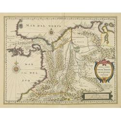
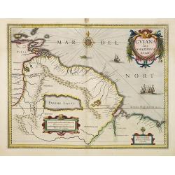
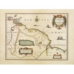
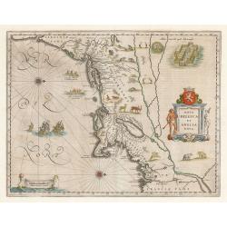
Guiana Siue Amazonu, Regio
Striking. 1635 map of the northwestern part of South America including Lake Parima (Parime Lacus), and the route to El Dorado. The map covers from Isla Margarita and the ...
Date: Amsterdam, 1635
Selling price: ????
Please login to see price!
Sold in 2016
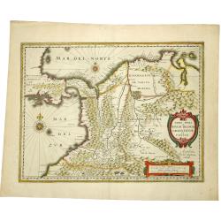
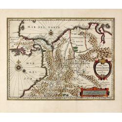
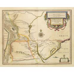
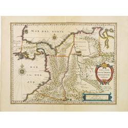
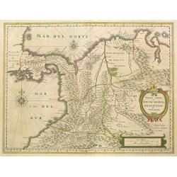
TERRA FIRMA et NOVUM REGNUM GRANATENSE et POPAYAN.
A fine example of this handsome map of modern-day Panama and Colombia. Decorated with a cartouche, a distance memorandum and two rose compasses. Very fine and rare. Frenc...
Date: Amsterdam, 1635
Selling price: ????
Please login to see price!
Sold in 2019
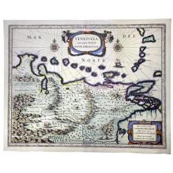
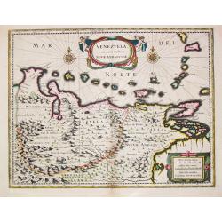
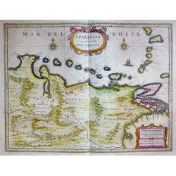
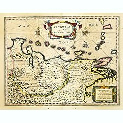
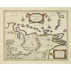
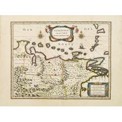
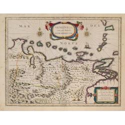
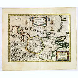
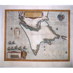
VENEZUELA cum parte Australi Novae Andalusiae.
A nice example of Blaeu's map showing two compass roses, a lovely cartouche and a ship. In the land are shown mountains, trees an exotic bird and a sheep. From the first ...
Date: Amsterdam, 1635
Selling price: ????
Please login to see price!
Sold in 2020
Venezuela, cum parte Australi Novae Andalusiae.
Venezuela, cum parte Australi Novae Andalusiae. A very fine example of Willem Blaeu's map of Venezuela and Columbia, embellished with two cartouches, two compass-roses...
Date: Amsterdam, c. 1635
Selling price: ????
Please login to see price!
Sold in 2023
![[Lot of 7 maps] Paraguay, Ó Prov. de Rio de la Plata cum regionibus With Arnold Montanus's and Tirion's of the countries bordering the Rio de la Plata. and Isaak Tirion's map of the same area.](/uploads/cache/18260-(2)-250x250.jpg)
[Lot of 7 maps] Paraguay, Ó Prov. de Rio de la Plata cum regionibus With Arnold Montanus's and Tirion's of the countries bordering the Rio de la Plata. and Isaak Tirion's map of the same area.
Willem Blaeu, founder of the famous publishing firm. Originally publishing pilot-guides, he issued his first atlas, 'Atlantis Appendix', in 1630, followed by his "...
Date: 1635
Selling price: ????
Please login to see price!
Sold in 2022
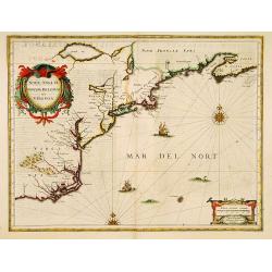
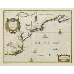
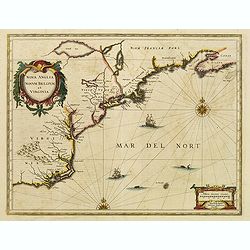
Nova Anglia Novum Belgium et Virginia.
In the 1636 edition of the Appendix , Johannes Janssonius inserted this important and influential map of the eastern seaboard from C. of Feare (Cape Look out) to Nova Sco...
Date: Amsterdam, 1636
Selling price: ????
Please login to see price!
Sold in 2019
Nova Anglia Novum Belgium et Virginia.
In the 1636 edition of the Appendix , Johannes Janssonius inserted this important and influential map of the eastern seaboard from C. of Feare (Cape Look out) to Nova Sco...
Date: Amsterdam 1636
Selling price: ????
Please login to see price!
Sold
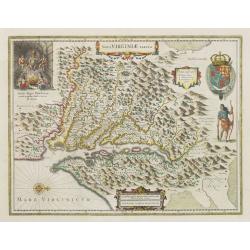
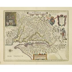
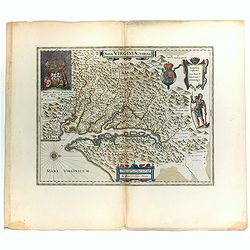
Nova Virginiae Tabula.
One of the most important maps of the Chesapeake Bay region, credited with disseminating knowledge of the English settlement in Virginia throughout Europe in the 17th cen...
Date: Amsterdam, ca. 1636
Selling price: ????
Please login to see price!
Sold
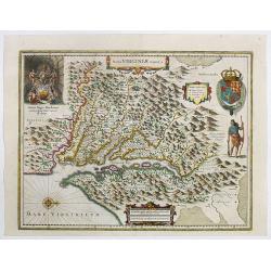
Nova Virginiae Tabula.
One of the most important maps of the Chesapeake Bay region, credited with disseminating knowledge of the English settlement in Virginia throughout Europe in the 17th cen...
Date: Amsterdam, ca. 1636
Selling price: ????
Please login to see price!
Sold in 2022
Nova Anglia Novum Belgium et Virginia.
In the 1636 edition of the "Appendix," Johannes Janssonius inserted this critical and influential map of the eastern seaboard from C. of Feare (Cape Lookout) to...
Date: Amsterdam, 1636
Selling price: ????
Please login to see price!
Sold in 2021
Venezuela cum parte Australi Novae Andalusiae Amstelodami Henricus Hondius Excudit.
A well executed engraved map that covers the Venezuelan coast of South America, east to the mouth of the Orinoco, and including the offshore islands from Aruba through Do...
Date: Amsterdam, 1636
Selling price: ????
Please login to see price!
Sold in 2016
![[Lot of 7 maps and gravure] Nova Hispania et Nova Galicia. [with map of Guatamala]](/uploads/cache/IMG_2235-250x250.jpg)
[Lot of 7 maps and gravure] Nova Hispania et Nova Galicia. [with map of Guatamala]
Willem Blaeu’s beautiful map of Mexico is decorated with a very large title-cartouche with the coat-of-arms of the king of Spain, another cartouche and two ships and a ...
Date: Amsterdam, ca 1636
Selling price: ????
Please login to see price!
Sold in 2023
![[lot of 8 maps/ prints of the Caribbean] Cuba Insula, inset: Havanna portus; Hispanolia Insula; Insula Iamaica; Ins. S. Ioannis; I.s. Margareta.](/uploads/cache/20279-(4)-250x250.jpg)
[lot of 8 maps/ prints of the Caribbean] Cuba Insula, inset: Havanna portus; Hispanolia Insula; Insula Iamaica; Ins. S. Ioannis; I.s. Margareta.
Re-issue of Gerard Mercator's small atlasA lot of 8 maps and prints of the Caribbean.
Date: Amsterdam, 1630-1636
Selling price: ????
Please login to see price!
Sold in 2022
Terra Firma et Novum Regnum Granatense et Popayan.
Decorative, old colored copper engraved map of Colombia by J. Janssonius. Shows parts of Ecuador with Esmeraldas in the south-west, up to Venezuela in the East. With the ...
Date: Amsterdam, 1637
Selling price: ????
Please login to see price!
Sold in 2015
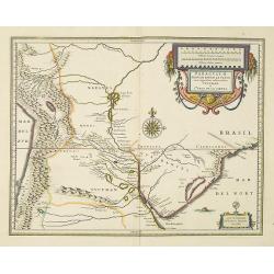
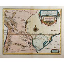
PARAGUAY, O PROV. DE RIO DE LA PLATA cum regionibus adiacentibus..
Early map showing this northern Patagonia territory. Also showing Rio de Janeiro, Sao Paolo, Santa Cruz of Bolivia, Paraguays, Uruguay, Buenos Ayres, Chili and Santo Iago...
Date: Amsterdam, 1635-1638
Selling price: ????
Please login to see price!
Sold in 2022
VENEZUELA, cum parte Australi NOVAE ANDALUSIAE.
A finely engraved, decorative map. The islands Trinidad, Margarita, Aruba and Curaçao are shown as well. With decorative title cartouche.From "le Théâtre du monde...
Date: Amsterdam, 1635-1638
Selling price: ????
Please login to see price!
Sold in 2012
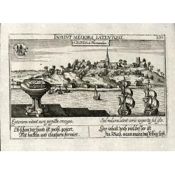
Olinda de Phernambuco
Cooper engraved view of Olinda the historical city in the Brazilian state of Pernambuco from D. Meisner "Sciographia Cosmica" printed 1638 in Nuremberg. With La...
Date: Nuremberg, 1638
Selling price: ????
Please login to see price!
Sold in 2009
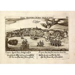
S. Salvator in Brasilien
Cooper engraved view of Salvador, Bahia in Brazil from D. Meissner "Sciographia Cosmica" printed 1638 in Nuremberg. With Latin and German aphorism and sailing b...
Date: Nuremberg, 1638
Selling price: ????
Please login to see price!
Sold in 2009
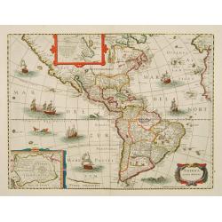
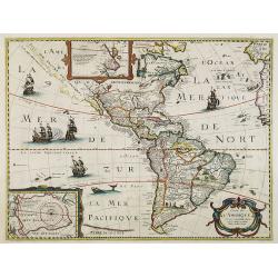
America noviter delineata.
An important map of the Western Hemisphere. Derived from Jodocus Hondius' map of 1618.Very detailed, filled with place names. With many curious geographical errors of the...
Date: Frankfurt, 1638
Selling price: ????
Please login to see price!
Sold in 2010
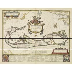
Mappa Aestivarum Insularum alias Barmudas.
Blaeu based his work on John Speed's remarkably accurate map of 1626-1627. It shows the island divided into tribes and lots, and below the map itself appear the names of ...
Date: Amsterdam, 1638
Selling price: ????
Please login to see price!
Sold in 2015
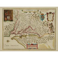
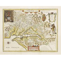
Nova Virginiae Tabula.
The map is based on the first state of Smith's map, 1612, and is slightly larger and more expertly engraved. In 1629 the Hondius plate was purchased by Blaeu who deleted ...
Date: Amsterdam, 1638
Selling price: ????
Please login to see price!
Sold

Nova Belgica et Anglia Nova.
Orientated with north to the right. This is one of the earliest maps to concentrate solely on this area of the colonies, excluding Virginia and the extreme north east coa...
Date: Amsterdam, 1638
Selling price: ????
Please login to see price!
Sold in 2010
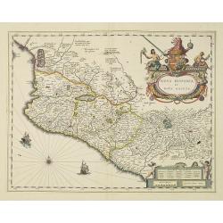
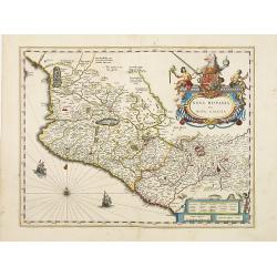
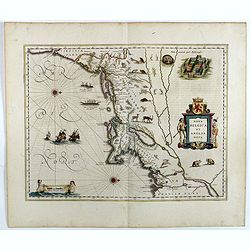
Nova Hispania et Nova Galicia.
Map of New Spain and New Galicia shows the city of Mexico situated by a large lake, as well as the location of many silver and gold mines. The map's elaborate cartouche i...
Date: Amsterdam, 1638
Selling price: ????
Please login to see price!
Sold in 2010
Terra Firma et Novum regnum Granatense et Propayan.
Fine copy, with wide margins of this handsome map of the Isthmus of Panama and northwestern South America including most of present day Columbia and part of Venezuela. Te...
Date: Amsterdam, 1638
Selling price: ????
Please login to see price!
Sold in 2010
Venezuela, cum parte Australi novae Andalusiae.
A finely engraved, decorative map with Latin text on the reverse. The islands Trinidad, Margarita, Aruba and Curaçao are shown as well. With decorative title cartouche.A...
Date: Amsterdam, 1638
Selling price: ????
Please login to see price!
Sold in 2010
Paraguayo prov. de Rio de La Plata cum regionibus..
A beautiful map of Paraguay, and parts of Peru, Chile, Argentina, Brazil and Bolivia. Much of the area was still "Terra Incognita" so there are few towns and ci...
Date: Amsterdam, 1638
Selling price: ????
Please login to see price!
Sold in 2018
Tabula Magellanica.
A map of South America's extremity with the Strait of Magellan and Le Maire Strait.The coastlines are depicted as very mountainous, while the interior is completely witho...
Date: Amsterdam, 1638
Selling price: ????
Please login to see price!
Sold
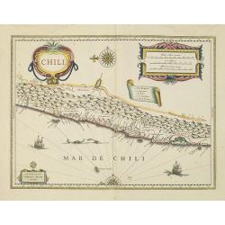
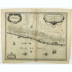
Chili.
Willem Blaeu's very decorative map of Chili with two large and beautiful cartouches, a compass and ships. The modern cities of Santiago (identified on the map as "S ...
Date: Amsterdam, 1638
Selling price: ????
Please login to see price!
Sold in 2010
Guiana sive amazonum regio.
This decorative map shows Guiana with the neighboring Trinidad and the adjacenting Amazon river. In the left lower side is a decorative renaissance mileage scale and in t...
Date: Amsterdam, 1638
Selling price: ????
Please login to see price!
Sold in 2010
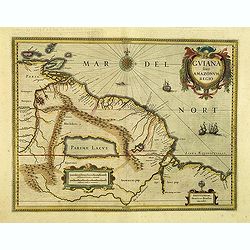
Guiana sive Amazonum Regio.
Copper engraving, hand colored in outline when published. A highly decorative map showing Guiana extending westwards to Trinidad and Margarita Island, dominated by a huge...
Date: Amsterdam, 1638
Selling price: ????
Please login to see price!
Sold in 2012
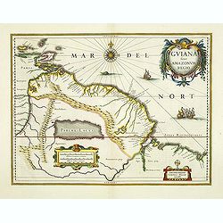
Guiana sive Amazonum Regio.
Important map extending from the Isla Margarita in the northwest to the coast of northern Brazil near Sao Luis east of the Amazon delta. The map locates at its center a l...
Date: Amsterdam, 1638
Selling price: ????
Please login to see price!
Sold in 2012
Nova Belgica et Anglia Nova.
Orientated with north to the right. This is one of the earliest maps to concentrate solely on this area of the colonies, excluding Virginia and the extreme north east coa...
Date: Amsterdam, 1638
Selling price: ????
Please login to see price!
Sold in 2013
America septentrionalis.
A first state of this important map showing California as an island. Lacking any imprint in the cartouche, lower left. From the first French text edition. The north-west ...
Date: Amsterdam 1639
Selling price: ????
Please login to see price!
Sold
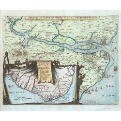
Abbildung der Statt und Festung Parayba in der Landschaft Brasilia.
A splendid map of the region of Paraiba and the forts at the mouth of the Paraiba. The map illustrates the Dutch incursion into the Portuguese territory and shows the Dut...
Date: Frankfurt, 1639
Selling price: ????
Please login to see price!
Sold in 2015
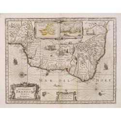
Accuratissima BRASILIAE Tabula.
A decorative map with a title cartouche of two natives, in the interior is an inset of Baya de Todos os Sanctos (Salvador) and "Villa d'Olinda de Pernambuco", i...
Date: Amsterdam, 1639
Selling price: ????
Please login to see price!
Sold in 2013
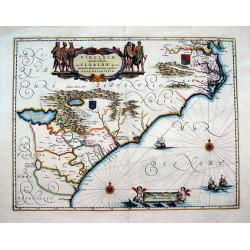
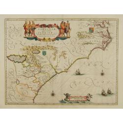
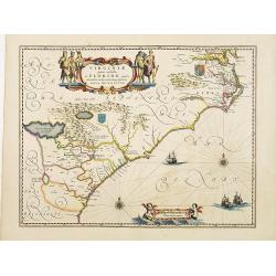
Virginiae Partis australis, et Floridae partis orientalis, interjacentiumqs regionum Nova Descriptio
Important map of the East Coast, from the Chesapeake Bay to Georgia with numerous early place names including Jamestown, Cape Fear, and Newport News. Two coat of arms ill...
Date: Amsterdam, 1639
Selling price: ????
Please login to see price!
Sold in 2016
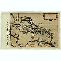
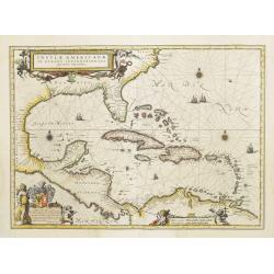
The Ylandes of the West Indies.
Rare map of the West Indies or Caribbean islands from Florida to the northern part of South America. Cartographic elements include degrees of latitude, compass rose, sea ...
Date: London, 1635-1639
Selling price: ????
Please login to see price!
Sold in 2019
Chili.
Very decorative map of Chili with two large and beautiful cartouches, a compass and ships. Rare without text on verso. From a French composite atlas. Read more about Dutc...
Date: Amsterdam, Paris, ca. 1639
Selling price: ????
Please login to see price!
Sold in 2018
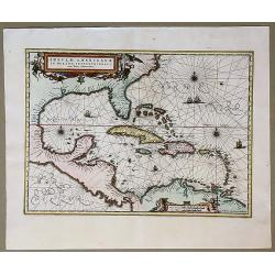
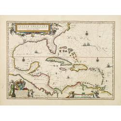
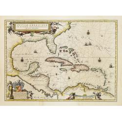
Insulae Americanae in Oceano Septentrionali, cum Terris Adiacentibus.
Early map of the West Indies. Janssonius' edition of Hessel Gerritsz' important map of 1631 made after his voyage to South America and the West Indies during 1628.From Ja...
Date: Amsterdam, 1639
Selling price: ????
Please login to see price!
Sold in 2020
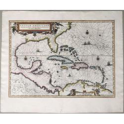
Insulae Americanae in Oceano Septentrionali, cum Terris Adiacentibus.
An early map of the West Indies. Janssonius' edition of Hessel Gerritsz' important map of 1631 made after his voyage to South America and the West Indies during 1628. Fro...
Date: Amsterdam, 1639
Selling price: ????
Please login to see price!
Sold in 2020
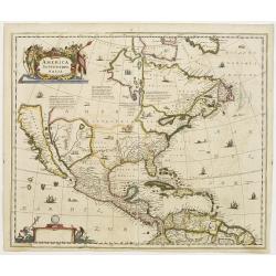
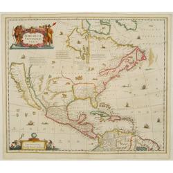
Carte de L'Amerique. . .
The map is based on the Jodocus Hondius map of 1618. The entire west coast of North America, including nomenclature, is erased and replaced by a dotted coastline with the...
Date: Paris, 1640
Selling price: ????
Please login to see price!
Sold in 2016
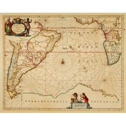
Mar di Aethiopia.
This from Johannes Janssonius' sea-atlas 'De Water-Weereld' covers the area between the Cape of Good Hope and the most southern tip of South America. Giving many place n...
Date: Amsterdam, 1640
Selling price: ????
Please login to see price!
Sold in 2021
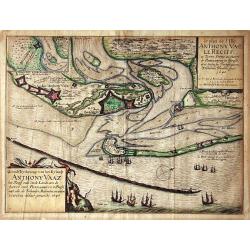
Grondt-Tekening van het Eylandt ANTHONY VAAZ het Reciff ende vaste Landt aen de haven van PERNAMBUCO in Brasil..
EXTREMELY RARE MAP engraved by Willem Hondius and published by Claes Jansz. Visscher.A detailed map of the Island of Anthony Vaaz. In upper left corner an inset of Fort d...
Date: Amsterdam 1640
Selling price: ????
Please login to see price!
Sold
Nova Virginiae Tabula.
The map is based on the first state of Smith's map, 1612, and is slightly larger and more expertly engraved. In 1629 the Hondius plate was purchased by Blaeu who deleted ...
Date: Amsterdam 1640
Selling price: ????
Please login to see price!
Sold
Virginiae Partis Australis, et Floridae Partis Orientalis.
Blaeu based this map on the Mercator-Hondius of 1606. A number of geographical improvements, however were incorporated, although two large fictions lakes accompanied by e...
Date: Amsterdam 1640
Selling price: ????
Please login to see price!
Sold
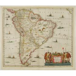
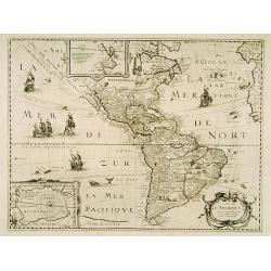
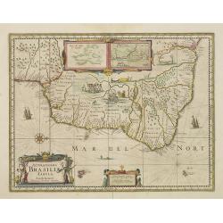
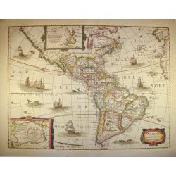
Americae Pars Meridionalis.
Decorated with several ships and sea monsters, and a cartouche flanked by engravings of six Indians, netted hammocks and South American fauna.
Date: Amsterdam 1640
Selling price: ????
Please login to see price!
Sold
America Septentrionalis.
Showing California as an island, and above, the north west of the continent left blank except for two legends explaining the discoveries to that date. The Hudson Bay is c...
Date: Amsterdam 1640
Selling price: ????
Please login to see price!
Sold
America noviter delineata.
With inset details of the North and South Poles, and several ships and sea-monsters. Hondius shows the imaginary island of Frisland, Southeast of Iceland, and gives Picar...
Date: Amsterdam 1640
Selling price: ????
Please login to see price!
Sold
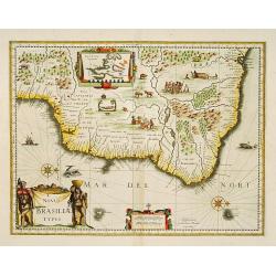
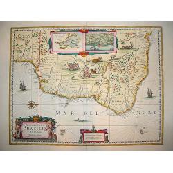
Novus Brasiliae Typus.
A decorative map with a title cartouche of two natives: in the interior is an inset of Baya de todos os Sanctos (Salvador), indigenous wild life and cannibal scenes. Orig...
Date: Amsterdam 1640
Selling price: ????
Please login to see price!
Sold
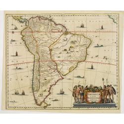
Americae Pars Meridionalis.
Finely engraved map of South America. Decorated with several ships and sea monsters, and a cartouche flanked by engravings of six Indians, netted hammocks and South Ameri...
Date: Amsterdam 1640
Selling price: ????
Please login to see price!
Sold
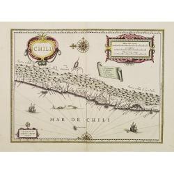
Chili.
Willem Blaeu's very decorative map of Chili with two large and beautiful cartouches, a compass and ships.
Date: Amsterdam 1640
Selling price: ????
Please login to see price!
Sold
Venezuela, cum parte Australi novae Andalusiae.
A finely engraved, decorative map with Latin text on the reverse. The islands Trinidad, Margarita, Aruba and Curaçao are shown as well. With decorative title cartouche.T...
Date: Amsterdam 1640
Selling price: ????
Please login to see price!
Sold
Nova Hispania et Nova Galicia.
Map of New Spain and New Galicia shows the city of Mexico situated by a large lake, as well as the location of many silver and gold mines. The map's elaborate cartouche i...
Date: Amsterdam 1640
Selling price: ????
Please login to see price!
Sold
Virginiae Partis Australis, et Floridae Partis Orientalis.
Blaeu based this map on the Mercator-Hondius of 1606. A number of geographical improvements, however were incorporated, although two large fictions lakes accompanied by e...
Date: Amsterdam 1640
Selling price: ????
Please login to see price!
Sold
Insulae Americanae in Oceanus Septentrionali cum Terris..
General map of the West Indies extending from Virginia to the mouth of the Orinoco, and destined to be copied in various shapes by many other publishers.Title cartouche t...
Date: Amsterdam 1640
Selling price: ????
Please login to see price!
Sold
Guiana sive Amazonum Regio.
Nice map extending from the Isla Margarita in the northwest to the coast of northern Brazil near Sao Luis east of the Amazon delta. The map locates at its center a large ...
Date: Amsterdam, 1640
Selling price: ????
Please login to see price!
Sold in 2008
Terra Firma et Novum regnum Granatense et Propayan.
Fine copy, with wide margins of this handsome map of the Isthmus of Panama and northwestern South America including most of present day Columbia and part of Venezuela. Te...
Date: Amsterdam, 1640
Selling price: ????
Please login to see price!
Sold
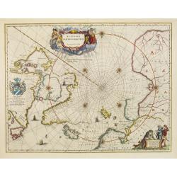
Regiones Sub Polo Arctico.
One of the many cases of duplication by the firms of Blaeu and Hondius/Jansson. In this case, Blaeu has copied Jansson's map of 1637. It depicts rhumb lines radiating fro...
Date: Amsterdam, 1640
Selling price: ????
Please login to see price!
Sold in 2009
Accuratissima Brasiliae Tabula.
Early map of Brazil showing settlements, coastal features, and the hereditary captaincies of the 17th century. The named cities include Sao Sebastian (Rio de Janeiro), Sa...
Date: Amsterdam, c.1640
Selling price: ????
Please login to see price!
Sold in 2011
Terra Firma et Novum Regnum Granatense et Popayan
The northwest corner of South America including present day Panama and Columbia. Shows Panama City, Cartagena and Cali. Graphically depicts the rugged terrain of the uppe...
Date: Amsterdam, 1640
Selling price: ????
Please login to see price!
Sold in 2009
Carte de L'Amerique Corrigee et augmentee dessus toutes les autres . . .
Very rare map of the Americas engraved by Michel van Lochom. A second state who clearly shows signs of reworking and Burden believes that it is the same as that of 1624 l...
Date: Paris, 1640
Selling price: ????
Please login to see price!
Sold in 2016
Paraguayo Prov. De Rio De La Plata cum regionibus..
This is an early map showing this northern Patagonia territory. Also showing Rio de Janeiro, Sao Paolo, Santa Cruz of Bolivia, Paraguay, Uruguay, Buenos Ayres, Chili and ...
Date: Amsterdam, 1640
Selling price: ????
Please login to see price!
Sold in 2009
Venezuela, cum parte Australi novae Andalusiae.
A finely engraved, decorative map. The islands Trinidad, Margarita, Aruba and Curaçao are shown as well. With decorative title cartouche.
Date: Amsterdam, 1640
Selling price: ????
Please login to see price!
Sold in 2009
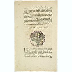
Circumferentia terrae continet miliaria germanica 5400, italica vero 21600.
Text page from "Introduction" of a Blaeu Atlas, Chapter VII. "De la division du Globe en 360 parties: du circuit de la terre, de sa longeur & largeur.T...
Date: Amsterdam, c.1640
Selling price: ????
Please login to see price!
Sold in 2014
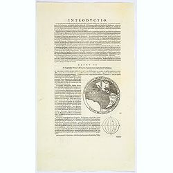
Circumferentia terrae continet miliaria germanica 5400, italica vero 21600.
The map of the Western hemisphere has a banner text "Circumferentia terrae continet miliaria germanica 5400, italica vero 21600". On verso a globe with climates...
Date: Amsterdam, ca. 1640
Selling price: ????
Please login to see price!
Sold in 2023
Venezuela cum parte Australi Novae Andalusiae.
Latin text on verso. A finely engraved, decorative map of Venezuela. The islands of Trinidad and Tobago, Margarita, Aruba and Curaçao are shown. Local animals are depict...
Date: Amsterdam, ca. 1640
Selling price: ????
Please login to see price!
Sold in 2017
Paraguayo Prov. De Rio De La Plata cum regionibus..
This is an early map showing this northern Patagonia territory. Also showing Rio de Janeiro, Sao Paolo, Santa Cruz of Bolivia, Paraguay, Uruguay, Buenos Ayres, Chilli and...
Date: Amsterdam, ca. 1640
Selling price: ????
Please login to see price!
Sold in 2017
Terra Firma et Novum Regnum Granatense et Popayan.
A very decorative, large, early map of modern-day Panama and Colombia. With Latin text on verso.
Date: Amsterdam, 1640
Selling price: ????
Please login to see price!
Sold in 2018
Nova Belgica et Anglia Nova.
Orientated with north to the right. This is one of the earliest maps to concentrate solely on this area of the colonies, excluding Virginia and the extreme north east coa...
Date: Amsterdam, 1640
Selling price: ????
Please login to see price!
Sold in 2017
TABULA MAGELLANICA qua Tierra del Fuego, cum. . .
Blaeu’s influential Map of Tierra del Fuego showing the Important Strait of Le Maire. A fine example of Willem Janszoon Blaeu's map of the Straits of Magellan and Tierr...
Date: Amsterdam, ca 1640
Selling price: ????
Please login to see price!
Sold in 2020
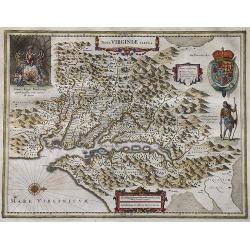
Nova Virginiae Tabula.
Blaeu's beautiful map of Virginia, Maryland and the Chesapeake Bay region on North America's eastern seaboard. It shows the discoveries in the area as detailed by John Sm...
Date: Amsterdam, ca 1640
Selling price: ????
Please login to see price!
Sold in 2022
Nova Belgica Et Anglia Nova
An important and early colonial era map of the Dutch and English colonies of northeast America by the renowned 17th century map maker, Willem Janszoon Blaeu. The map is d...
Date: Amsterdam, 1640
Selling price: ????
Please login to see price!
Sold in 2023
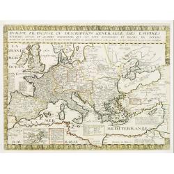
Evrope Francoise Ov Description Generalle Des Empires..
Unrecorded early Canadiana. Rare map of Europe with an inset of Canada or Nouvelle France. The inset has been missed in the bibliographies of North America (not cited in ...
Date: Paris, 1641
Selling price: ????
Please login to see price!
Sold
Nova Virginia Tabula.
Early map of Virginia. Being Henricus Hondius' derivative of John Smith's highly important map of Virginia, 1612. Orientation west to top.Title in an Antwerp style cartou...
Date: 1641
Selling price: ????
Please login to see price!
Sold in 2019
Insulae Americanae in Oceanus Septentrionali cum Terris..
General map of the West Indies extending from Virginia to the mouth of the Orinoco, and destined to be copied in various shapes by many other publishers.Title cartouche t...
Date: Amsterdam 1642
Selling price: ????
Please login to see price!
Sold
Nova Virginiae Tabula.
The map is based on the first state of Smith's map, 1612, and is slightly larger and more expertly engraved. In 1629 the Hondius plate was purchased by Blaeu who deleted ...
Date: Amsterdam, 1642
Selling price: ????
Please login to see price!
Sold
Insulae Americanae in Oceanus Septentrionali cum Terris..
General map of the West Indies extending from Virginia to the mouth of the Orinoco, and destined to be copied in various shapes by many other publishers.Title cartouche t...
Date: Amsterdam, 1642
Selling price: ????
Please login to see price!
Sold
Acuritisima Brasilia Tabula.
A very decorative, desirable map of Brazil. The work is filled with native scenes depicting various activities, including a cannibalism ritual and villagers tending to a ...
Date: Amsterdam, ca. 1642
Selling price: ????
Please login to see price!
Sold in 2008
America noviter delineata.
With inset details of the North and South Poles, and several ships and sea-monsters. Hondius shows the imaginary island of Frisland, Southeast of Iceland, and gives Picar...
Date: Amsterdam, 1642
Selling price: ????
Please login to see price!
Sold in 2011