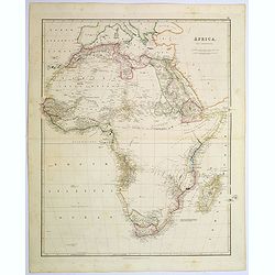
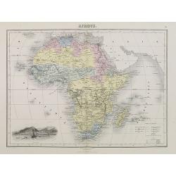
Africa.
A lovely looking steel engraved map of the mighty continent of Africa. The map highlights vividly how much exploration was carried on around the coastline, and how the va...
Date: London, 1839
Selling price: ????
Please login to see price!
Sold in 2017
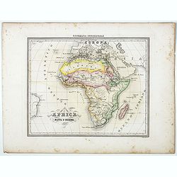
L'Africa. . .
A rare double-page map of the African continent. According to the title cartouche, prepared by A de La Sage for l'Atlante Storico, Letterario, Biografico, Archeologico. ....
Date: Venice, 1840
Selling price: ????
Please login to see price!
Sold in 2009
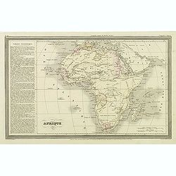
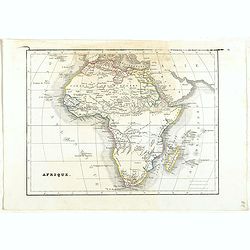
Afrique.
Finely engraved map of Africa prepared by A.H.Dufour and engraved by Giraldon-Bovinet. Published by Jules Renouard in his uncommon atlas "Le globe Atlas classique Un...
Date: Paris, Jules Renouard, ca.1840
Selling price: ????
Please login to see price!
Sold in 2011
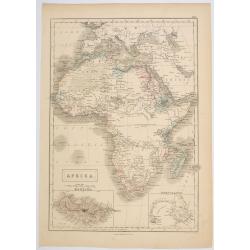
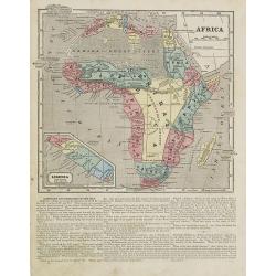
Africa.
Sidney Hall's general map of the continent of Africa, published during the first half of the 19th century by A & C Black in Edinburgh. The map features two inset maps...
Date: Edinburgh, ca 1840
Selling price: ????
Please login to see price!
Sold in 2023
Afrique.
Detailed map of Africa, prepared by Charles V. Monin (fl.1830-1880) a French cartographer of Caen and Paris. Published in Atlas Universel de Géographie Ancienne &c Mo...
Date: Paris, 1845
Selling price: ????
Please login to see price!
Sold in 2022

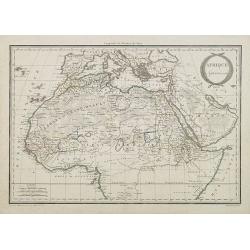
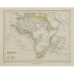
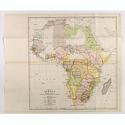
Africa, North Part.
A pair of maps of northern and southern Africa on one sheet, from “Black's General Atlas”, published by A. & C. Black in Edinburgh in 1846. A pair of precisely detail...
Date: Edinburgh, 1846
Selling price: ????
Please login to see price!
Sold in 2017

Karta öfver Africa.
An very rare map of Africa with Swedish text. This is an heavenly updated version of his map of 1818 and is now dated 1828.In lower part a color key to Portuguese, Spanis...
Date: A. Wiborgs förlag, Stockholm, ca. 1848
Selling price: ????
Please login to see price!
Sold in 2017
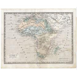
Afrique.
A very decorative 19th century map showing Africa. The map is surrounded by portraits, animals, vegetation, etc.. Includes also three views of Alexandria, Cairo and Alger...
Date: Paris 1850
Selling price: ????
Please login to see price!
Sold
Afrique.
A decorative 19th century map of the continent colored to show the colonial possessions and major tribal kingdoms. The interior is mostly void of detail. The map is surro...
Date: Paris 1850
Selling price: ????
Please login to see price!
Sold
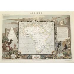
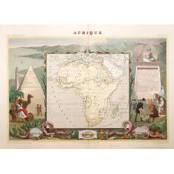
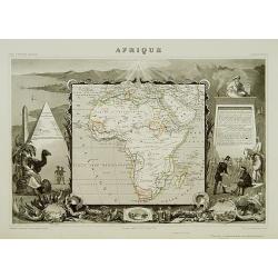
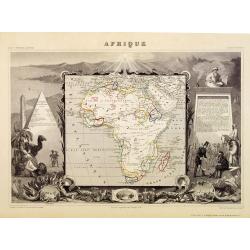
Afrique
Classic Levasseur treatment; smaller map (8" x 9") embedded in very elaborate engraved scenes about the people, animals and plants of the subject region. Small ...
Date: Paris, 1850
Selling price: ????
Please login to see price!
Sold
Afrique.
A decorative 19th century map of the continent colored to show the colonial possessions and major tribal kingdoms. The interior is mostly void of detail. The map is surro...
Date: Paris, 1850
Selling price: ????
Please login to see price!
Sold in 2008
Afrique Septentrionale.
A uncommon map of northern part of Africa with nice detail to the different borders and depiction of the "Zahara ou Grand désert".
Date: Paris, 1850
Selling price: ????
Please login to see price!
Sold in 2009

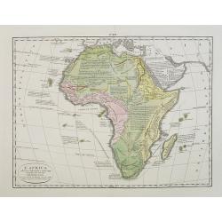
Afrique. Physique et division. Etudes 33 et 35.
Map of Africa. With an empty central Africa " Pays entievement inconnu aux Européens".
Date: Paris, c.1850
Selling price: ????
Please login to see price!
Sold in 2010
![[Untitled Map of Africa]](/uploads/cache/23279-250x250.jpg)
[Untitled Map of Africa]
Fine manuscript map of Africa with relief shown pictorially. Signed by the author in the lower right corner.Lower left Décembre 1852.
Date: Paris, 1852
Selling price: ????
Please login to see price!
Sold
Afrique/Publiee par Logerot.
Original map on steel drawn by A. R. Frémin, engraved by Ch. Dyonnet, published by Logerot.
Date: Paris, 1853
Selling price: ????
Please login to see price!
Sold in 2008
Africa.
Map of Africa. From Sidney E. Morse''s: System of Geography for the use of schools , published by Harper and brothers, 329 Pearl Street, New York.An 150 years old map wit...
Date: New York, 1855
Selling price: ????
Please login to see price!
Sold in 2008
Africa Mappa d'Insieme.
Uncommon map of the African continent prepared by Francesco Costantino Marmocchi. Above the map "Geografia Commerciale". From "Il Globo Atlante di carte Ge...
Date: Genova, Paolo Rivara fu Giacomo, 1858
Selling price: ????
Please login to see price!
Sold in 2021
Afrika.
Uncommon map of Africa. Lithography by J.H. van Weijer, published in Atlas der geheele Aarde [?] in 24 kaarten. With colored key to English, French, Dutch, Spanish, Port...
Date: Groningen, ca. 1860
Selling price: ????
Please login to see price!
Sold in 2008
Afrique spheroidale..
Very detailed map from Atlas Spherodidal & Universel de géographie , Prepared by F.A.Garnier and edited by Jules Renouard, rue de Tournon, Paris. Uncommon map with de...
Date: Paris 1861
Selling price: ????
Please login to see price!
Sold
Afrika nach den neuesten Entdeckungen
A ''smaller'' Stieler map no 27, from his atlas for schools. About 8x10 inches. Unusual version as the cartouche is not in the usual circle upper right corner, but has be...
Date: Gotha/Perthes 1864
Selling price: ????
Please login to see price!
Sold
![[Set of three maps] Africa.](/uploads/cache/39122-250x250.jpg)
[Set of three maps] Africa.
The first map is large scale map of the continent of Africa by Edward Weller. Nicely colored with plenty of map detail.The second map of Africa is by A.K. Johnston,(600 x...
Date: London, ca. 1865
Selling price: ????
Please login to see price!
Sold in 2017
Afrique.
A decorative map of Africa from Géographie Universelle, Atlas Migeon. With an engraving of Saint Helena Island lower left corner. Saint Helena is located in the South Atl...
Date: Paris, 1874
Selling price: ????
Please login to see price!
Sold
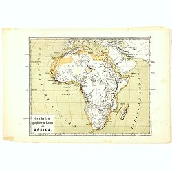
Oro-Hydrographische Kaart van Afrika.
One of the earliest thematic maps of Africa published in the Netherlands from "Atlas der natuurkundige aardrijkskunde. . .". prepared by Nicolaas Wilhelmus Post...
Date: Amsterdam, C.L. Brinkman, 1883
Selling price: ????
Please login to see price!
Sold in 2016
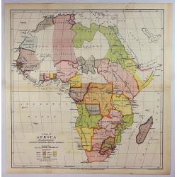
A map of Africa Showing the boundaries settled by international treaties & agreements.
Map of Africa with a color key showing the British, French, German, Italian, Portuguese and Spanish boundaries settled by international treaties and agreements. Free trad...
Date: London, Edward Stanford, 1890
Selling price: ????
Please login to see price!
Sold in 2017
A Map of Africa Showing the Boundaries Settled by International Treaties & Agreements.
An interesting political map showing the boundaries of Africa, based on treaties and agreements as at 1890. It was printed for Sandford’s Geographical Establishment.The R...
Date: London, 1890
Selling price: ????
Please login to see price!
Sold in 2018
Afrique.
Oversized and detailed map of Africa drawn by J. Hansen and engraved by Erbard Freres (Paris), with part of Arabia and Madagascar. Published by E.Andriveau-Goujon.
Date: Paris, 1895
Selling price: ????
Please login to see price!
Sold in 2019
![[Africa].](/uploads/cache/46143-250x250.jpg)
[Africa].
A detailed map of Africa published by the very successful St. Petersburg publisher "Cartographic institution A.Ilina".Alexey Afinogenovich Ilyin was a lieutenan...
Date: St. Petersburg, 1899
Selling price: ????
Please login to see price!
Sold in 2020
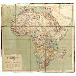
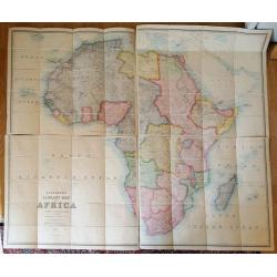
Stanford's library Map of Africa.
A monumental map of Africa, divided into four parts (north-west, north-east, south-west and south-east), each with a label on the colored paper backing to verso. Together...
Date: London, 1904
Selling price: ????
Please login to see price!
Sold in 2021

Gran quadriglione Africano nel carnevale 1885 (Rana N. 28 - Cent. 20).
Imposing allegorical representation of the colonial aims of the European powers with regard to Africa. On the left the director of the large quadrociale the lady Diplomaz...
Date: Bologna, 1905
Selling price: ????
Please login to see price!
Sold in 2019
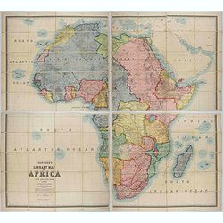
Stanford's Wall Map: Library Map of Africa, in 4 sheets.
Stanford's Library Map of Africa, constructed by A. K. Johnston. Scale, 94.34 miles= 1 inch, or 1: 5,977,382 of nature. Large wall map of the continent in four sheets. F...
Date: London 1866, updated for 1920
Selling price: ????
Please login to see price!
Sold in 2015
![[Title in Ottoman Turkish: map of Africa].](/uploads/cache/44734-250x250.jpg)
[Title in Ottoman Turkish: map of Africa].
An uncommon Ottoman map of Africa. The continent is divided into different regions but no town names. In the lower left corner inset with title and key.Read more about th...
Date: Ottoman Empire, ca. 1920
Selling price: ????
Please login to see price!
Sold in 2022
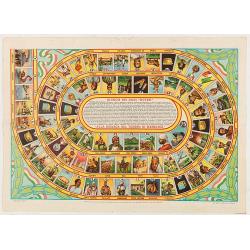
Giuoco dei dadi Nutro. Alla ricerca del tersoro di menelick
Goos-game with 75 numbered boxes, numbered counterclockwise, advertising of the Nutro company. Prepared by L. Ciompi. The boxes starting with the departure of a voyage in...
Date: Milan, Off. Graf.S.Tavella & C., 1936
Selling price: ????
Please login to see price!
Sold in 2020
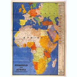
Schaubild von Afrika mit bildlicher Darstellung der wichtigsten Bodenschätze und Wirtschaftgüter.
Decoratively designed economic map of Africa with pictorial representation of the most important mineral resources and economic goods for the respective area.In right han...
Date: München, ca. 1939
Selling price: ????
Please login to see price!
Sold in 2022
![Suid-Afrikaanse Lugdiens Roetekaart dui binnenlandse dienste en die Springbokdiens-route... [with on verso] South African Airways Route Map Shewing Internal Services and Springbox ...](/uploads/cache/82045-250x250.jpg)
Suid-Afrikaanse Lugdiens Roetekaart dui binnenlandse dienste en die Springbokdiens-route... [with on verso] South African Airways Route Map Shewing Internal Services and Springbox ...
Suid-Afrikaanse Lugdiens Roetekaart dui binnenlandse dienste en die Springbokdiens-route... [with on verso] South African Airways Route Map Shewing Internal Services and ...
Date: Johannesburg, 1950
Selling price: ????
Please login to see price!
Sold in 2018
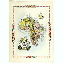
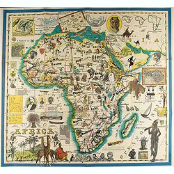
Afrique.
color printed pictorial map of Africa, with decorative title cartouche and borders, depict countries, regions, major cities, animals and wildlife. Includes decorative com...
Date: Paris, 1951
Selling price: ????
Please login to see price!
Sold in 2018
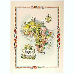
Afrique.
color printed pictorial map of Africa, with decorative title cartouche and borders, depict countries, regions, major cities, animals and wildlife. Includes decorative com...
Date: Paris, 1951
Selling price: ????
Please login to see price!
Sold in 2020
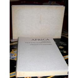
Africa on maps dating from the twelfth to the eighteenth century. Africa auf Karten des 12. bis 18. Jahrhunderts.
First edition. Cloth over Boards. First edition. Elephant folio. The book contains Seventy-seven reproductions of maps of Africa from European map collections, with maps ...
Date: Leipzig, 1968
Selling price: ????
Please login to see price!
Sold in 2017
Africa.
A pictorial map of Africa.
Date: Italy, 1986
Selling price: ????
Please login to see price!
Sold in 2020
