Browse Listings in Africa
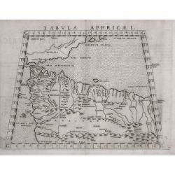
Tabula Aphricae I .
One of the earliest maps of Morocco and Tunisia, the northern coast of Africa, including Gibraltar and the Balearic islands. Early double page copperplate engraving from ...
Date: Venice, 1574
Selling price: ????
Please login to see price!
Sold in 2014
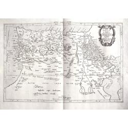
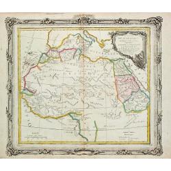
Tab. IV. Africae in qua Libya Interior et Exterior. Aethiopia sub Aegypto et Interior. . .
This finely engraved Ptolemaic map of Northern Africa shows the twin lake sources of the Nile located near the Lune Montes. The Niger River is prominently featured in Lib...
Date: Utrecht, 1695?
Selling price: ????
Please login to see price!
Sold in 2018
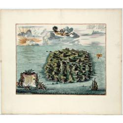
Saint Helena.
This fine hand colored original copper-plate engraved antique map of the Island of St Helena in the southern Atlantic that was published by Pieter Van der Aa. With cherub...
Date: Leiden, ca 1710
Selling price: ????
Please login to see price!
Sold in 2020
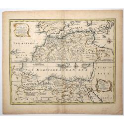
A New & Accurate Map of the Western parts of BARBARY, containing FEZ, MOROCCO, ALGIERS, TUNIS & BILEDULGERID.
An attractive and detailed map of North Africa by Emanuel Bowen (ca.1693-1767) an English engraver, publisher and map seller, active in London from about 1720. Map is enh...
Date: London, ca 1750
Selling price: ????
Please login to see price!
Sold in 2019
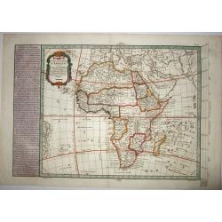
CARTE NOUVELLE D'AFRIQUE.
An original rare copper engraved map of 'modern' Africa by Moithey, published by Etienne André Philippe de Pretot, Paris, from the atlas 'Cosmographie Universelle' - ca ...
Date: Paris ca 1765
Selling price: ????
Please login to see price!
Sold in 2021
Partie de L' Afrique en deca de l' Equateur.
Louis Brion de la Tour (1756-1823), ' Atlas Géneral, Civil et Ecclésiastique', 1766, ' Atlas Général', 1790-98. Louis Charles Desnos (fl.1750-70), Le Rouge's 'Atlas N...
Date: Paris, 1766.
Selling price: ????
Please login to see price!
Sold
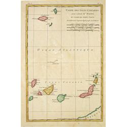
Carte des Isles Canaries, avec l'Isle de Madere et celle de Porto Santo
Rigobert Bonne (1727-1795), French cartographer. His maps are found in a.o. Atlas Moderne (1762), Raynal's Histoire Philos. du Commerce des Indes (1774) and Atlas Encyclo...
Date: Paris, 1784.
Selling price: ????
Please login to see price!
Sold
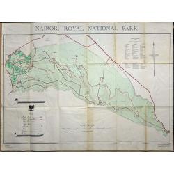
Nairobi Royal National Park.
A large plan of Nairobi National Park, first edition September 1956. A key shows the physical make up of the park plus a list of Mammals and Reptiles found in the park.
Date: Nairobi, 1956
Selling price: ????
Please login to see price!
Sold in 2019
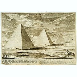
Pyramides Aegyptiacae.
An imaginary view.
Date: (19th)
Selling price: ????
Please login to see price!
Sold
![[Africa - General continental map with Ottoman script]](/uploads/cache/44735-250x250.jpg)
[Africa - General continental map with Ottoman script]
Post card size map in Ottoman script showing the continent of Africa from Mehmet Eşref’s ‘Küçük Atlas’, a rare portfolio of loose-leaf maps wit...
Date: Istanbul, Şirket-i Mürettibiye ve Karacoğlu Matbaas&#
Selling price: ????
Please login to see price!
Sold
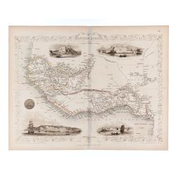
Western Africa.
Double page steel engraved map. Map accompanied by vignette scenes of Christiansborg, Cape Coast Castle, Sierra Leone and Bakel. Decorative scrolling and title cartouche ...
Date: London & New York: The London Printing and Publish
Selling price: ????
Please login to see price!
Sold in 2020
