Browse Listings

Workers - Hu Xian Peasant Painting.
Published by Shanghai renmin chubanshe (上海人民出版社). A fine Chinese propaganda poster at the tim...
Place & Date: Shanghai, September, 1974 - variant 1975
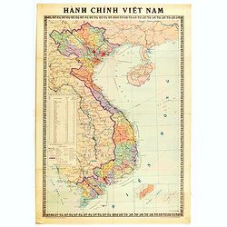
Hành Chính Việt Nam.
Uncommon map of Vietnam published in 1976, one year after the end of the Vietnam War. In April 1976, the National Assembly decided to reiterate Hanoi as the capital of th...
Place & Date: Hanoï, 1976

The Soviet Political Poster.
An attractive Soviet Union political poster. The poster was part of a set of reproductions from poster originally published from 1919 to the 1970s. Published in Leningrad...
- $25 / ≈ €22
Place & Date: Leningrad, Aurora Art Publishers, 1976

Folies Bergere - Hélène Martin présente Folie je t'adore. . .
Original advertising poster for Les Folies Bergère cabaret in Paris. The Théâtre des Folies Bergère is a famous Parisian performance hall inaugurated on May 2, 1869 a...
- $380 / ≈ €333
Place & Date: Paris, ca. 1977
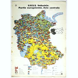
U.R.S.S. Industrie. Partie européenne, Asie centrale. (3)
Map of Eastern Russia. Propaganda poster for Russia's industry. Text in French. Editions de l'Agence de presse Novosti".More about War Maps & Propaganda maps [+]
- $100 / ≈ €88
Place & Date: USSR, 1978
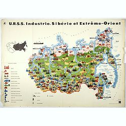
U.R.S.S. Industrie. Sibérie et Extreme-Orient. (4)
Map of Siberia. Propaganda poster for Russia's in and export of industrial goods from Siberia. Editions de l'Agence de presse Novosti".More about War Maps & Prop...
- $150 / ≈ €131
Place & Date: USSR, 1978
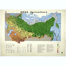
U.R.S.S. Agriculture. (6)
Map of Russia. Propaganda poster for Russia's in and export of industrial goods. With a key in bottom. Text in French. Editions de l'Agence de presse Novosti".More a...
- $100 / ≈ €88
Place & Date: USSR, 1978
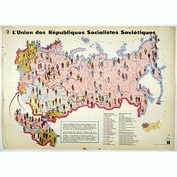
L'Union des Républiques socialistes Soviétiques. (2)
Map of Russia. Propaganda poster showing Russia' s population. With a key. Text in French. Editions de l'Agence de presse Novosti".More about War Maps & Propagan...
- $100 / ≈ €88
Place & Date: USSR, 1978

PARADIS LATIN - Number One.
Poster for the Nuit de Paradis review, by Jean-Marie Rivière, the first Paradis Latin review in 1979.Read more about Poster History [+]
- $180 / ≈ €158
Place & Date: Paris, 1978
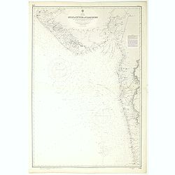
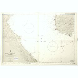
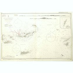
India west coast Gulf of Cutch to Vijaydurg . . .
Chart of India's west coast map surveyed by the hydrographer Captain JF Parry. A highly corrected version of Admiralty chart 2736 originally published 1st July 1915. Date...
- $200 / ≈ €175
Place & Date: London, 1915-1980
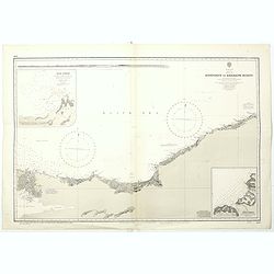
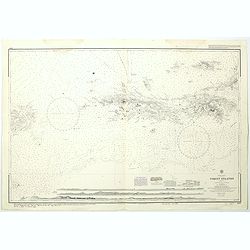
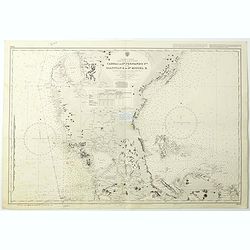
Black sea - Sheet IX - Bosporus to Kerempe Burnu . . .
A highly corrected version of Admiralty chart 2238 originally published 16th June 1854. Edition Date 1980.Detailed chart of Bosporus. With prohibited landing places in pu...
- $100 / ≈ €88
Place & Date: London, 1854-1980

Bal du Moulin Rouge Paris - Femmes Femmes Femmes..
Design by René Gruau for Moulin Rouge. René Gruau (1909-2004) was a Franco-Italian artist. He enjoyed real success after World War II working as a fashion illustrator f...
Place & Date: Paris, G. Cravenne, ca. 1980

Panache la nouvelle revue du Lido.
Very decorative poster designed by René Gruau for the Lido and its review Panache on the Champs Elysées, Paris. The bluebells are pictured for the 1985 show. René Grua...
Place & Date: Paris, ca. 1980

Lido - Le plus célèbre cabaret du monde.
Very decorative poster designed by René Gruau for the Lido, showing a show leader lady. René Gruau (1909-2004) was a Franco-Italian artist. He enjoyed real success afte...
- $300 / ≈ €263
Place & Date: Paris, ca. 1980

Lido de Paris - Nouveau spectacle Christian Clerico présente C'est magique.
Very decorative poster designed by René Gruau for the Lido, made on the occasion of the release of the new show "It's magic". René Gruau (1909-2004) was a Fra...
- $300 / ≈ €263
Place & Date: Paris, ca. 1980

Anamu Buru to Latakia including Iskenderun Körfezi.
A highly corrected version of Admiralty chart 2632 originally published 25 November 1955 under the Superintendence of Captain K.SB. Collins. Edition Date 1984 Detailed ch...
- $100 / ≈ €88
Place & Date: London, 1955 - 1984

Boris Eltsine.
Artist poster about Boris Eltsine, by Mirjam Dijkema (1984) who studied Illustration and Graphic Design and Art History. Currently Mirjam is teaching design and art theor...
- $100 / ≈ €88
Place & Date: Groningen, ca. 1990
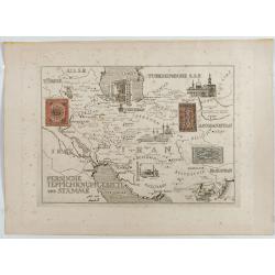
Persische Teppichknüpfgebiete und Stämme.
Map of Iran and neighboring countries in German language, published in limited edition probably in France : "Gravée à l'eau-forte et au burin. Edition limitée&quo...
Place & Date: France ?, after 1935 - before 1991
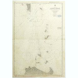
China Sea Luzon Strait between Luzon and Tai-Wan from the United States & Japanese Government chartsto 1929. . . (3804)
A highly corrected version of Admiralty chart 3804 originally published 18 September 1925 under the Superintendence of Captain P.H. Douglas. New Editions 18th December 19...
- $150 / ≈ €131
Place & Date: London, 1929 / 1992
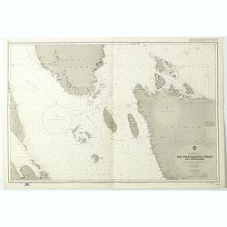
China sea Gulf of Tongking (Southern sheet).
A highly corrected version of Admiralty chart 3989 originally published 11 Mai 1962 under the Superintendence of Captain EG Irving. Detailed chart including the coasts of...
- $80 / ≈ €70
Place & Date: London, 1962 - 1992
West Indies Virgin islands Sheet III Tortola I. to Culebra including St. Thomas...
An British Admiralty chart of the Virgin Islands. A highly corrected version of Admiralty chart 2452 originally published 15th December 1856 under the Superintendence of ...
- $135 / ≈ €118
Place & Date: London, 1856- 1988-1993
China Sea Philippine Islands - San Bernandino Strait and approaches. (3370)
A highly corrected version of Admiralty chart 3370 originally published 14th November 1924 under the Superintendence of Captain H.P. Douglas. Edition Date 1982 with furth...
- $150 / ≈ €131
Place & Date: London, 1924 / 1996

Philippine Islands - Semirara, Ilin and Ambulong 1.s with part of Mindoro. (971)
A highly corrected version of Admiralty chart 971 originally published 15th February 1866 under the Superintendence of Captain G.H. Richards. Edition Date 1991 with furth...
- $150 / ≈ €131
Place & Date: London, 1866 / 1999
West Indies Anguilla to Puerto Rico showing the approaches to the Virgin Islands . . .
A highly corrected version of Admiralty chart 130 originally published 22nd June 1868 under the Superintendence of Captain G.H. Richards. Edition Date 1974 with further c...
- $100 / ≈ €88
Place & Date: London, 1868 - 1999

Philippine Islands - Mindanao West Coast - Basilan Strait to Camiguin Island including Tubbataha Reefs. . . (3811)
A highly corrected version of this oversized Admiralty chart 3811 originally published 26th February 1925 under the Superintendence of Captain P.H. Douglas. Edition Date ...
- $150 / ≈ €131
Place & Date: London, 1925 / 2005
Philippine Islands - Luzon - west and east coast. Cabra I. to S.n Fernando P.t. Diapitan B. to S.n Miguel B. . . (3806)
Detailed chart of Luzon Island with Manila Bay, Cabra Island to S. Fernando Point Diapitan Bay to S. Miguel Bay.A highly corrected version of Admiralty chart 3806 origina...
Place & Date: London, 1922 / 2006
Selling price: $100
Sold in 2018

July tenth: The Flaming Tsunamis fatter than Albert a billion ernies stuck lucky and the best of the worst.
Poster by Justin Santora, numbered 8/65 ans signed in pencil, in the lower right margin.Santora began working as a freelance illustrator and screen printer like some of C...
Place & Date: Chicago, ca. 2008
![[Lot of 3] Celestial chart depicting astronomical division of the earth.](/uploads/cache/IMG_2256-250x250.jpg)
[Lot of 3] Celestial chart depicting astronomical division of the earth.
A chart depicting the astronomical division of the earth. With on both sides a descriptionary text. All within an elaborate and very decorative border. A very fine item. ...
- $250 / ≈ €219
Place & Date: Paris, L.C. Desnos,1761.
![[Set of two maps of the Pacific Ocean with transportation lines, with Ottoman script]](/uploads/cache/44327-250x250.jpg)
[Set of two maps of the Pacific Ocean with transportation lines, with Ottoman script]
Two post card size maps showing the Pacific Ocean with transportation lines. The maps are in Ottoman script prepared by Mehmet EŞREF in a small atlas : ...
- $200 / ≈ €175
Place & Date: Istanbul, Şirket-i Mürettibiye ve Karacoğlu Matbaas&#