Browse Listings in Map Types > Postal / Road maps
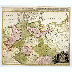
Regni Borussiae et Electoratus Brandenburgici, Ceterarum que, Quae Fridirici Reg. Bor. sceptro reguntur nec non finitimarum Prov. Delineatio. . .
Rare post-route map covering Germany, Poland, the Low Countries, and Czechoslovakia. The map gives in detail the German postal routes and postal stations. Within the lowe...
- $750 / ≈ €636
Date: Amsterdam, 1704
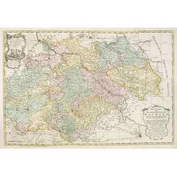
Neue Karte des Kuhrfürstenthums Sachsen. . .
Scarce road map, first published by Peter Schenk II (1698-1775) in his "Neuen Sächsischen Atlas". It is based on a map already created and 1732 and improved in...
- $750 / ≈ €636
Date: Amsterdam, 1758
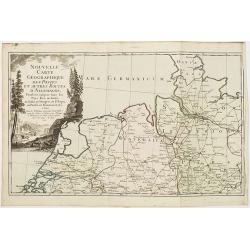
Nouvelle carte géographique des postes et autres routes d'Allemagne. . .
Map showing the northern provinces in Germany and part of the Netherlands. Decorative title cartouche in the upper left corner. A so-called post road maps.
- $80 / ≈ €68
Date: Paris, 1766
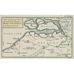
Post-Route von Brüssel nach Gent, Brügge, Ostende, nach Antwerpen und Bergen op Zoom. N°XXIII
Very rare post route maps map centered on Gent, and showing the postal routes in-between Oostende, Bruges, Gent, Brussels, Mechelen, Lier, Antwerp, Bergen op Zoom, etc. f...
- $250 / ≈ €212
Date: Nürnberg, Weigel and Schneider, ca.1785

Carte des routes de poste de la Russie européenne, exécutée par ordre de S.E.M. le duc de Feltre ministre de la Guerre, ...
Post-route map on a scale of 1:2 500 000 made during the French campaign in Russia, which began June 24, 1812. With a table of the conventional signs and a table of conve...
Date: Paris, Dépôt Général de la Guerre 1812

