Browse Listings in Map Types > Folding maps
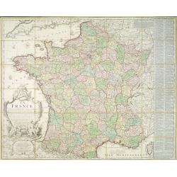
La France divisée en 83 départemens suivant les décréts de l'Assemblée Nationale, sanctionnés per le Roi. . .
An interesting folding map of France divided in 83 departments, to the right the 83 departments added on past-on slips. Another past-on is advertising Desnos' atlas in la...
Date: Paris, 1790
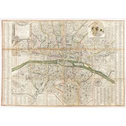
Nouveau plan routier de la ville et faubourgs de Paris. 1791
Plan quadrillé en segments, entoilé. De part et d'autre "Table alphabétique des rues". Plan mis à jour auquel on a ajouté dans un cartouche en bas : un pla...
Date: Paris, 1791
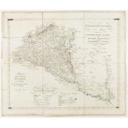
Niederungern Ivtes Blatt enthaltend die Schumegher, Tolner, Baranyer. . . Partie IVè de la basse hongrie contenant les comtes de Schumegh, de Tolna, de Baranya. . .
Map of Hungary. In the lower explicative key. Detailed map of the Southern part of Hungary with Kopreinitz until Lake Balaton, which is one of the most popular summer des...
Date: Kunst u. Industrie Compt., Vienna, 1803
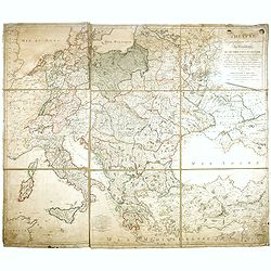
THEATRE Géographique des Guerres du Continent, OU SE TROUVENT EN ENTIER Les Royaumes de Hollande, ...
Large wall map of Central Europe, centered on Poland and including present-day Germany, the Low Countries, Italy, Greece, Bulgaria, Turkey and the Black Sea in the lower ...
Date: Paris, Paul-André Basset, 1806
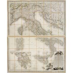
Carte Statistique, Politique, et Mineralogique de l'Italie o'u sont tracées toutes les routes, relais, et distances de postes. . .(2 Maps)
Folding map, extending west to east from Monaco to Otranto and north to south from The Alps to Malta, inset of Greece,. Cartouche depicting Rome and her classical past. P...
Date: Paris, 1816
![[Untitled map of a part of Poland and Prussia].](/uploads/cache/25710-250x250.jpg)
[Untitled map of a part of Poland and Prussia].
Large folding map, being upper right part of a multi-sheet map, showing the northern part of Poland with good detail around Gdansk. Published by Jean Claude Dezauche (17...
- $400 / ≈ €339
Date: Paris, ca. 1816-1824
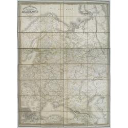
General karte vom europaischen Russland.
Rare second edition of a lithographed wall map of the European part of the Russian empire, at a scale of about 1:3,200,000. With the title in a elaborately decorated lett...
Date: Weimar, Geographisches Institut, 1840
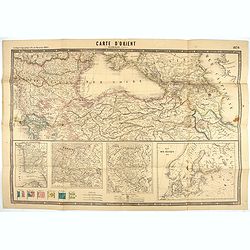
Carte d'Orient par Kraminski ingénieur.
Large map of Orient, with an insert of four maps (Constantinople plan - Map of Europe - Map of Russia - Plan of Baltic sea). With flags in the lower left part. color key ...
Date: Paris, 1854
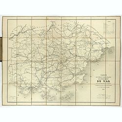
Carte routière et administrative du département du Var dressée sous l'administration et l'approbation de M. Montois, officier de la légion d'honneur, préfet , par J.B CHABET.
Folding-map of the Maritime Alps, and the Mediterranean coastline of Fréjus, Ramatuelle, St Tropez, Toulon. Engraved by Erhard, geographer and engraver (1821-1880) at th...
- $125 / ≈ €106
Date: Paris, 1865
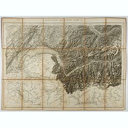
Generalkarte der Schweiz. Blatt III.
Folding map showing Leman lake. The map, engraved by Müllhaupt, is probably part of the 'Topographical Atlas of the Federal General Staff reduced under the direction of ...
- $75 / ≈ €64
Date: Bern, 1873
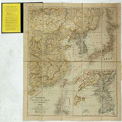
Stanford's Map of Eastern China, Japan and Korea. 1898.
Charming, folding map of the east coast of China, Korea and Japan. In the lower right corner inset map of Korea (265x512mm.). In the lower left, a key to Treaty Ports, Su...
- $750 / ≈ €636
Date: London, ca. 1898
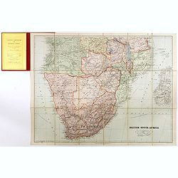
British South Africa.
With the signature of Alan Sillitoe (1928-2010), who was England’s best writer of proletarian fiction. From an early age, geography and maps were a very important part ...
- $450 / ≈ €382
Date: London, 1923
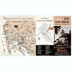
Welcome to old San Diego, birthplace of California 1769.
Publicity leaflet for "Manuel's Restauranté" in the Casa de Pedrorena. On one side a pictorial map of San Diego and "Tourist Map of Old San Diego", w...
- $75 / ≈ €64
Date: San Diego, ca. 1935

