Browse Listings in Map Types > Carte-a-figures
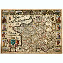
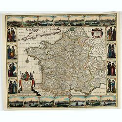
Gallia. Nova Galliae descriptio . . .
Very rare and early map of France with figures on three sides with views of cities, portraits (Henri IV and Marie de Medicis) and costumes. The map was directly influence...
Date: Amsterdam, 1616
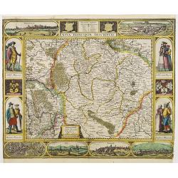
Nova Franconiae Descriptio.
In 1626 Abraham Goos engraved a single-sheet "carte à figures"- map of Franconia with decorative borders for Joannes Janssonius. In the center part of the top ...
- $2000 / ≈ €1696
Date: Amsterdam, 1626
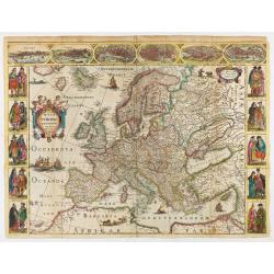
Nova Europae descriptio.
Rare early issue of the map of Europe with the lower border removed and without text on the reverse. Variant : The map has no longer the lower border, doesn't have text o...
Date: Amsterdam, after 1630
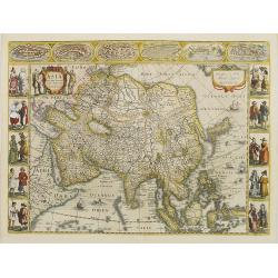
Asia recens summa cura delineata.
This is the rare early issue with decorative paneled borders. In upper border views and plans of Famagusta, Rhodos, Damascus, Jerusalem, Aden and Ormus. Originally engrav...
Date: Amsterdam, 1632
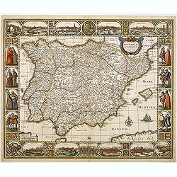
Nova et accurata Tabula Hispaniae. . .
Second state. This "carte à figures"- map of Spain and Portugal shows the geographical image introduced by Hessel Gerritsz's 1612 wall map of Spain. The map is...
Date: Amsterdam, 1633

Europa recens descripta à Guilielmo Blaeuw.
On either side, columns depicting the manner of dress in the major countries of Europe, surmounted by nine city views and plans.For European mapmakers their own continent...
Date: Amsterdam, 1644
Nova Haec tabula Galliae. . .
Dated 1653. This handsome map of France is dedicated to Louis XIV, interesting in light of the nearly constant warfare between Louis and the Netherlands in the ensuing ye...
Date: Amsterdam, 1653
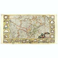
Fluviorum Rheni Mosae Mosellae Moeni Neccaris aliorumque minorum in eosdem se exonerantium et regionum circumjacentium descriptio
Fluviorum Rheni Mosae Mosellae Moeni Neccaris aliorumque minorum in eosdem se exonerantium et regionum circumjacentium descriptio Decorative map with 18 vignettes on thr...
- $750 / ≈ €636
Date: Amsterdam, ca. 1660

A new mape of Ye XVII Provinces of Low Germanie.
Showing all 17 Provinces of the Netherlands before the split between Spain and the Protestant Provinces under the House of Orange.The map was first published. At the same...
Date: London, 1676
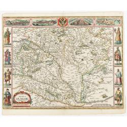
The mape of Hungari newly augmented by John Speede.
A wonderful carte-a-figures map of ‘Hungari’, comprising modern-day Hungary and parts of Slovakia. Showing two sets of four costumed figures on each side of the map a...
Date: Londres, Bassett and Chiswell, 1626 / 1676
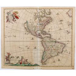
Novissima et Accuratissima Totius Americae descriptio..
Third state of one of the classic Dutch maps of the Americas and one of the most often copied.Lower right hand corner F. de Wit excudit. Longitudinal lines numbered to th...
Date: Amsterdam, [1678

