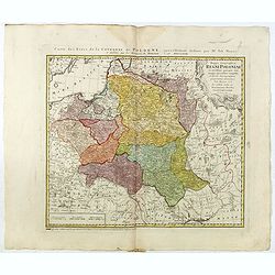
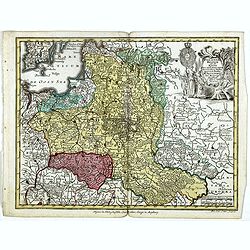
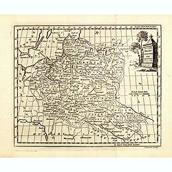
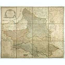
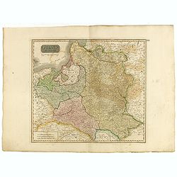
Mappa Geographica Regni Poloniae ex novissimis quotquot sunt mappis specialibus composita et al L.L. Stereographicae projectionis revocata a Tob. Mayero. . . .
Late Tobias Mayer detailed map Polish edition, updated in order to show the borders of the kingdom of year 1772 after the division of the territory.Mayer's map extends fr...
- $750 / ≈ €655
Date: Nuremberg, 1773
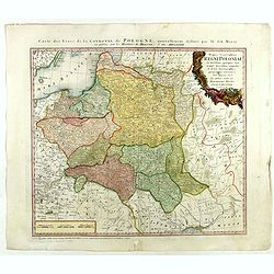
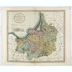
Mappa Geographica Regni Poloniae ex novissimis quot quot sunt mappis. . .
A map of Poland, Lithuania and Belarus, first published in 1750 by Homann Heirs, and now re-issued in 1773. Coastline includes all between Riga and Gdansk. Map is based o...
Date: Nuremberg, 1773
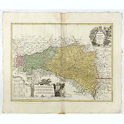
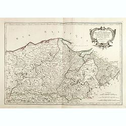
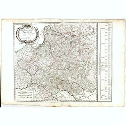
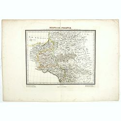
Lubomeriae Et Galliciae Regni Tabula Geographica: Cum Priv. Sac. Caes. Maiestatis Impensis Homannianorum Haeredum . . .
Rare map of the Kingdom of Galicia and Lodomeria prepared by F.L. Güssefeld, (1744-1808), who was a cartographer from Osterburg, studied at Brandenburg, worked in Weimar...
- $1500 / ≈ €1310
Date: Nuremberg, 1775
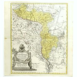
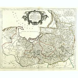
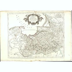
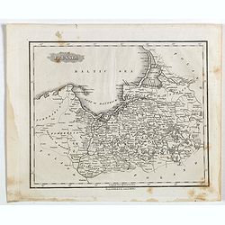
Charte von Russisch Litauen, welche die von Polen an Russland Abgetretene Woiewodschaften, Liefland, Witepsk, Mscislaw, und einem Theil der Woiewodschaften Polock und Minsk Enthalt.
An uncommon map of Belarus, together with parts of the Ukraine and Lithuania. Shows the rivers Dnieper and Dwiner from Liefland to Mscislaw and Woiwodschaft.. With the to...
- $500 / ≈ €437
Date: Nuremberg, 1775
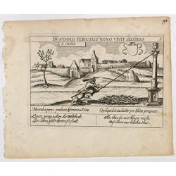
St. Cruis ( in eastern Poland.)
A very nice view of Kloster Heiligkreuz (Swiety Krzyz), in eastern Poland. In the foreground, a man climbing up a column is depicted. With a verse in two languages undern...
- $50 / ≈ €44
Date: Frankfurt, 1623-1778
Polonia regnum ut et magni Ducat Lithuania. . .
Miniature map of Poland, a reduction of the appropriate part of Seutter's folio map. Engraved by Tobias Conrad Lotter.From Atlas Minor, here published by Johann Martin Wi...
- $450 / ≈ €393
Date: Augsburg, J.M.Will, 1778
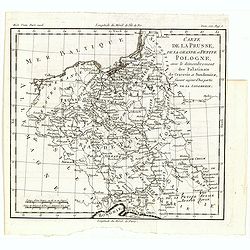
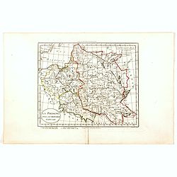
Carte de la Prusse, de la Grande et Petite Pologne, avec le démembrement des Palatinats de Cracovie et Sandomirz, faisant aujour d'hui partie de la Lodomerie.
A map of the Polish territories by Louis Brion de la Tour, from the work "Histoire universelle depuis le commencement du monde jusqu a present" published in Par...
Date: Paris, 1779
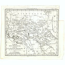
Carte des provinces annexées à la petite Pologne, et de la Gallicie, avec la Lodomerie, démembrées de la Pologne.
A map of the southern provinces of Poland by Louis Brion de la Tour, from the work "Histoire universelle depuis le commencement du monde jusqu a present" publis...
Date: Paris, 1779
Poland Lithuania and Prussia.
Uncommon miniature map of Poland, Lithuania and the Ukraine, engraved by Thomas Kitchin - with his signature in lower right bottom.
Date: London, 1782
![[No title] Northern part of Poland.](/uploads/cache/24263-250x250.jpg)
[No title] Northern part of Poland.
Attractive map centered on the northern part of Poland, including northern part of Eastern Germany.Prepared by Giovanni Antonio Bartolomeo Rizzi Zannoni, one of the leadi...
- $275 / ≈ €240
Date: Paris, ca 1783
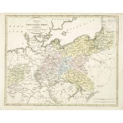
Carte De La Prusse Occidentale ou sont tracees les Provinces cedees Par la Pologne au Roi De Prusse . . . 1775
Finely and crisply engraved map of Western Prussia, now part of Poland on the Baltic Sea, including the Bay of Danzig. With ornamental title cartouche and noteworthy topo...
- $375 / ≈ €328
Date: Venice, 1776 - 1784
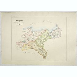
La Prusse divisée en Prusse Royale et Prusse Ducale.
The map extends from Memem, Danzig and Rosienne in the North to Novigrod in the southeast and Thorn on the Wessel in the southwest. Shows the Gulf of Danzig and part of P...
- $300 / ≈ €262
Date: Venice, 1776 - 1784
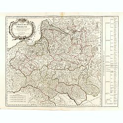
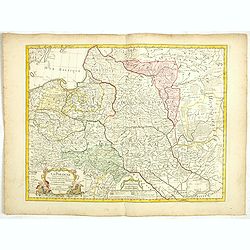
Royaume de Pologne.
Detailed map encompassing present-day Poland.Venetian edition of the map by R. de Vaugondy, to whom Santini gives credit in the cartouche.From "Atlas Universel"...
- $400 / ≈ €349
Date: Venice, 1776 - 1784

Carte de la Pologne Autrichienne contenant La Russie Rouge et la partie méridionale du Palatinat de Cracovie . . .
Detailed map with Krakow, including the areas of Malopolskie and Podkarpackie and including present-day Ukraine.Santini gives credit to Homann Heirs in the cartouche. Mal...
- $300 / ≈ €262
Date: Venise 1776-1784
La Prusse divisée en Prusse Royale et Prusse Ducale.
The map extends from Memem, Danzig and Rosienne in the North to Novigrod in the southeast and Thorn on the Wessel in the southwest. Shows the Gulf of Danzig and part of P...
Date: Venice, 1776 - 1784
Royaume de Pologne.
Detailed map encompassing present-day Poland. The table provides a breakdown of the sub-regions of the Polish Crown.Venetian edition of the map by R. de Vaugondy, to whom...
- $350 / ≈ €306
Date: Venice, 1776 - 1784

Carte De La Prusse Occidentale ou sont tracees les Provinces cedees Par la Pologne au Roi De Prusse . . . 1775
Finely and crisply engraved map of Western Prussia, now part of Poland on the Baltic Sea, including the Bay of Danzig. With ornamental title cartouche and noteworthy topo...
Date: Venice, 1776 - 1784
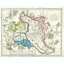
Carte générale de la Pologne : avec ses différens démembremence par les puissances partageantes en 1773 et 1795 / dessinée et dressée par Mariaval. . .
Very rare map of Poland, engraved by Tardieu l’Ainé, active at rue de Sorbonne 385.
Date: Paris, ca. 1795
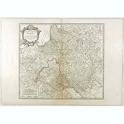
Le Royaume De Pologne, divise selon les Partages faits en 1772, 1793 et 1795, etnre la Russie, la Prusse et l'Autriche . . .
The uncommon later edition of this detailed map of Poland, showing the lands lost to Russia, Prussia and Austria in 1772, 1793 and 1795. with a color key added underneath...
Date: Paris, ca. 1796
Karte von Polen.
An attractive map of Poland. With a decorative title cartouche in the upper left-hand corner. Engraved by Ant. Amon. Franz Johann Josef von Reilly (Vienna 18 august 1766 ...
- $950 / ≈ €830
Date: Vienna, 1796
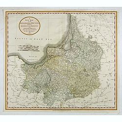
A New Map of the Kingdom of Prussia with its Divisions Into Provinces and Governments . . .
Highly detailed regional map of Prussia, including the Baltic regions and part of Poland, from Cary's Universal Atlas, one of the finest atlases of the period.
- $275 / ≈ €240
Date: London, 1799
La Pologne avec le dernier partage.
Uncommon map of Poland and Lithuania. Engraved by Alexandre Blondeau (1799-1828), with Brezesci in the center of the map.From "Atlas universal pour la géographie de...
- $200 / ≈ €175
Date: Paris, Hyacinthe Langlois, 1799
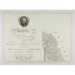
Karte von Ost-Preussen nebst Preussisch Litthauen und West-P
The title section of this important multi-sheet map of Prussia, Lithuania and Poland, showing territories of present Lithuania. With a medallion representing the King of ...
Date: Berlin, 1802
Poland from the best authorities.
Detailed map of Poland from "A New Geographical, Historical, and Commercial Grammar", by William Guthrie. William Guthrie (later engraver for Carey) London, UK....
Date: London, 1805
La Pologne Dressée sur ce qu'en ont donné Starovolsk, Beauplan, Hartnoch. . .
This is a late edition of the De L'Isle copper plate with a date of 1806. The copper plate was used many times and has several erased addresses. This one with address &qu...
- $750 / ≈ €655
Date: Paris, 1806
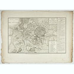
Accueil Consultation Plan du Siège de Danzig par le 10me. Corps de la Grande Armée, Avec les travaux des Français, tels qu'ils étaient le 25 Avril 1807.
A map of the siege of Danzig, 19 March-24 May 1807, showing the positions of the French siege works as they stood on 23 April. Napoleonic Wars (1803-15). Oriented with so...
Date: Paris, after 1810
A New Map of the Kingdom of Prussia with its Divisions Into Provinces and Governments. . .
A fine map by John Cary of Prussia, in what is now northern Poland and Lithuania. John Cary was considered "the most representative, able and prolific of English car...
- $250 / ≈ €218
Date: London, 1811
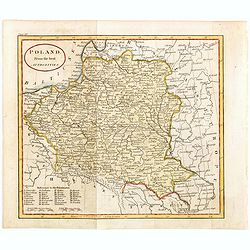
Poland As Divided.
This map covers Poland following Napoleonic Wars and the treaties of the 1815 Congress of Vienna.This map was first published in Thomson's New General Atlas of 1814. John...
Date: Edinburgh, 1817
![[Untitled map of a part of Poland and Prussia].](/uploads/cache/25710-250x250.jpg)
[Untitled map of a part of Poland and Prussia].
Large folding map, being upper right part of a multi-sheet map, showing the northern part of Poland with good detail around Gdansk. Published by Jean Claude Dezauche (17...
- $400 / ≈ €349
Date: Paris, ca. 1816-1824
Part of Prussia.
Attractive example of the scarce 1828 Malte-Brun map of modern day Poland and Lithuania. Published by Samuel Walker in 1828 as part of the American edition of Conrad Malt...
- $100 / ≈ €87
Date: Boston, 1828
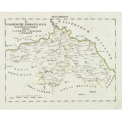
Oesterreich. B. Galizische Erbstaaten Koenigr: Galizien Kreis 1. Lemberg 2. Zloczow 3. Zolkiew.
Map depict the area north of the Black Sea, including the cities of Lemberg, Zolkiew, Brody.From "W. E. A. von Schliebens Atlas von Europa nebst Kolonien für Gesch�...
- $150 / ≈ €131
Date: Leipzig, G. J. Göschen, ca 1825-1830
Carte du pays compris entre Vistule et la Pregel.
Map of Poland regions, including Warsaw, part of Russia and Danzig bay, prepared by Auguste Henri Dufour (1798-1865). Engraved by Ch. Dyonnet.
- $75 / ≈ €66
Date: Paris, 1830
Reino de Polonia ò sea la parte unida a la Rusia por el repartimiento de 1795 que conserva el nombre de aquel antiguo reino.
Uncommon Spanish map of Poland from "Coleccion de mapas geograficos antiguos y modernos de autores clascicos", published by José Torner in Barcelona in 1831.R....
Date: José Torner, Barcelona, 1831
Karta öfver Preussiska riket.
An very rare map of Eastern part of Germany, with Pomerania and part of present-day Poland with Swedish text. This is an updated version of his map of 1820 and is now dat...
- $150 / ≈ €131
Date: A. Wiborgs förlag, Stockholm, ca. 1848
![Bataille de Pultusk, le 26 Decembre 1806. [manuscript map]](/uploads/cache/38810-250x250.jpg)
Bataille de Pultusk, le 26 Decembre 1806. [manuscript map]
Manuscript map of the siege of Pultusk (located on the west bank of the River Narew approximately 50 kilometres (31 mi) north of Warsaw), on 26 December 1806. With a colo...
- $1750 / ≈ €1529
Date: Breda, 1849
Provincia ecclesiastica di Gnesna e Posnania nella Prussia Vicar.ti apost.cl di Sassonia e Dei Ducati Analtini (Tav LXXXII)
A large-format map of western Poland with its different dioceses. The map is finely engraved and beautifully colored and was prepared by Girolamo Petri, a lawyer who serv...
- $500 / ≈ €437
Date: Rome, 1858
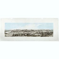
Widok Krakowa od Podgonza.
Bird's-eye view of Krakow city, with underneath the names of thirteen important buildings. Lithographed by J.Brydak after a photo by W. Rzewuskriego. Published by Czasu W...
- $750 / ≈ €655
Date: Krakow, ca. 1865
