Browse Listings in Europe > Netherlands > Brabant > maps
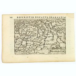
Brabantia.
A lovely miniature map of the Duchy of Brabant, published by Petrus Bertius, in Amsterdam at the beginning of the seventeenth century. There is a nice, small strap-work t...
Date: Amsterdam, 1606
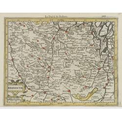
Brabantia.
Decorative regional map of northern Belgium and the Dutch province Brabant, extending north to Breda and south to Namur, with Antwerp and Brussels near the center.Oriente...
- $150 / ≈ €131
Date: Amsterdam, 1608
Novissima et Accuratissima Brabantiae Ducatus Tabula.
North is to the right. Like all other maps of Brabantiae Ducatus, it encloses the area between the rivers Rhine, Maas and Schelde, with Namur as the most southern town. O...
- $350 / ≈ €306
Date: Amsterdam, 1629
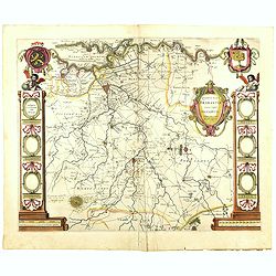
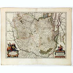
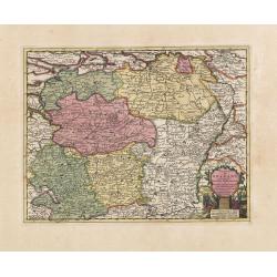
Quarta pars Brabantiae cujus caput Sylvaducis.
The coat of arms of Brabant and 's-Hertogenbosch do appear on the map. But the municipal arms in the columns on right and left-hand side have not yet been filled in. The ...
Date: Amsterdam, 1645
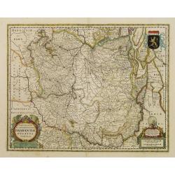
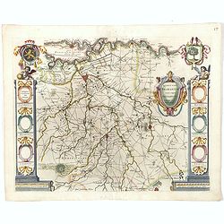
Brabantia Ducatus.
A very decorative map by Willem Blaeu with west is at the top. On the lower left a magnificent cartouche with a sitting female figure carrying a globe and compasses and t...
Date: Amsterdam, 1645
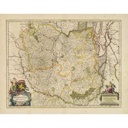
Quarta pars Brabantiae cujus caput Sylvaducis.
The coat of arms of Brabant and 's-Hertogenbosch do appear on the map. But the municipal arms in the columns on right and left-hand side have not yet been filled in. The ...
Date: Amsterdam, 1645
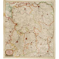
Brabantia Ducatus.
West is at the top. On the lower left a magnificent cartouche with a sitting female figure carrying a globe and compasses and the coat of arms of Brabant. Like all other ...
- $500 / ≈ €437
Date: Amsterdam, 1650
Ducatus Brabantiae tabula continens sacri imperii. . .
Rare issue of Cornelis Danckert's attractive map of Brabant.Decorative title cartouche lower left hand corner.
Date: Amsterdam, 1700
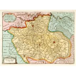
La Mayerie de BOLDVC,. . .
From his atlas Oorlogs tablessen, Oft uytgesochte Kaarten . Covering the so-called area Meierij van 's-Hertogenbosch . Eindhoven in the centre of the map.
Date: Amsterdam, 1706
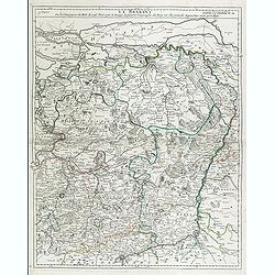
Carte du Brabant, suivant les Nouvelles Observations de Messrs de L'Academie Royale des Sciences etc. . .
Although not renowned for the originality of his work, Pieter van der Aa is highly thought of for the design and quality of his output. Showing the present-day Dutch and ...
- $300 / ≈ €262
Date: Amsterdam, 1713
Le Brabant. Ou la Campagne du Roy de 1746. . .
Uncommon map of Dutch and Belgium Brabant by George Louis Le Rouge, who was active from 1740- till 1780 as a publisher and was appointed engineer for the King of France.D...
- $300 / ≈ €262
Date: Paris, ca. 1750
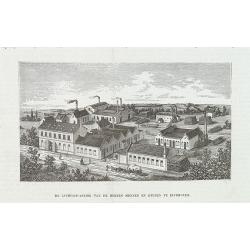
De luciferfabriek van de Heeren Mennen en Krunen te Eindhoven.
Wood engraving published in "Katholieke Illustratie", showing the match factories of Mennnen en Krunen in Eindhoven. Founded in 1870 by banker Christiaan Mennen...
- $40 / ≈ €35
Date: s-Hertogenbosch, H.Bogaerts, ca. 1885
