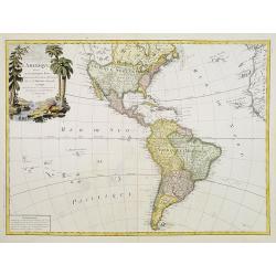
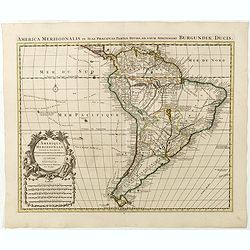
Browse Listings in America
![[Isle la Moche].](/uploads/cache/39909-250x250.jpg)
[Isle la Moche].
Scarce print with a German text sheet showing the Dutch fleet anchored off the Island of Mocha, near Concepción in Chile. The islanders sat on wooden stumps and watched ...
- $100 / ≈ €94
Place & Date: Frankfurt, M.Merian, 1633
![[Cavendish reaches Morro Moreno.]](/uploads/cache/39910-250x250.jpg)
[Cavendish reaches Morro Moreno.]
Scarce print with a German text sheet showing Cavendish’s fleet anchor at a place called Morro Moreno, on the coast of Chile. The Indians came down from the high cliffs...
- $80 / ≈ €75
Place & Date: Frankfurt, M.Merian, 1633
![[French seizure of Chiorera.]](/uploads/cache/39911-250x250.jpg)
[French seizure of Chiorera.]
Scarce print with a German text sheet showing the French torching and looting Chiorera. From de Bry's "Great American Voyages". Johann Theodor de Bry (1561-1623...
- $80 / ≈ €75
Place & Date: Frankfurt, M.Merian, 1633
![[Sir Walter Ralegh meets the King of Arromaia].](/uploads/cache/39916-250x250.jpg)
[Sir Walter Ralegh meets the King of Arromaia].
Scarce print with a German text sheet. During Ralegh’s voyage up the Orinoco in search of El Dorado, he met an old man who said he was the king of Arromaia. He claimed ...
- $125 / ≈ €117
Place & Date: Frankfurt, M.Merian, 1633
![[Black slaves escape punishment].](/uploads/cache/39920-250x250.jpg)
[Black slaves escape punishment].
Scarce print with a German text sheet. Many Black slaves, weary of ill treatment, managed to escape Spanish captivity and freely wandered the island, breaking into prison...
- $80 / ≈ €75
Place & Date: Frankfurt, M.Merian, 1633
![[Religious ritual on Hispaniola].](/uploads/cache/39921-250x250.jpg)
[Religious ritual on Hispaniola].
Scarce print with a German text sheet.On certain feast-days the Indian cacique, while beating a drum, led a procession of his people to the worship of their idol, which w...
- $80 / ≈ €75
Place & Date: Frankfurt, M.Merian, 1633
![[Captain Weert dines with the Chief].](/uploads/cache/39922-250x250.jpg)
[Captain Weert dines with the Chief].
Scarce print with a German text sheet. Captain Weert and the chief ate modestly on roast plantain, smoked fish and wine fermented from palm, bought by a local woman. Howe...
- $80 / ≈ €75
Place & Date: Frankfurt, M.Merian, 1633
Freti Magellanici ac novi Freti vulgo Le Maire. . .
A fine map of Tierra del Fuego. With an explanatory text of the passage by Barent Jansz. Potgieter who accompanied captain Sebald de Weert to the Straits in 1599/1600, be...
- $750 / ≈ €702
Place & Date: Amsterdam, ca. 1633
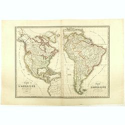
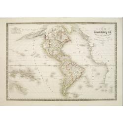
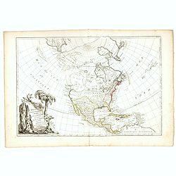
Carte de l'Amerique Septentrionale . . . / Carte de l'Amerique Méridionale . ..
Two maps of America on one sheet, by Nicolas Maire, a French geographer and published by Langlumé et Peltier.
- $250 / ≈ €234
Place & Date: Paris, 1834
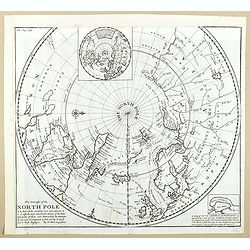
This Draught of the North Pole is to show all the Countries near and adjacent to it . . .
The polar map shows the latest discoveries and routes of numerous explorers during their attempts to find a Northwest and Northeast Passage, including James, Hudson, and ...
- $300 / ≈ €281
Place & Date: London, ca. 1728

Nieuwe gelyk Graadige Paskaart van de Kust van Guiana in West-Indien.
Detailed chart of Guiana in South America. Two scales are given in both maps: Dutch, French and English nautical miles.The inset chart provide detailed view of the Camopi...
- $650 / ≈ €608
Place & Date: Amsterdam, 1684 - 1704
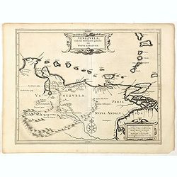
Venezuela, atque Occidentalis Pars Novæ Andalusiae.
Coastline of Venezuela with little interior development. Including Aruba, Bonaire, Curaçao, etc. Scarce map prepared by Hessel Gerritsz (1581-1632), former apprentice of...
- $600 / ≈ €561
Place & Date: Leiden, Elzevier, 1630
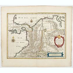
Terra Firma et Novum regnum Granatense et Propayan.
Handsome map of the Isthmus of Panama and north-western South America, including most of present day Columbia and part of Venezuela.Terra Firma is Panama, Veragua is Cost...
- $350 / ≈ €328
Place & Date: Amsterdam, ca. 1644
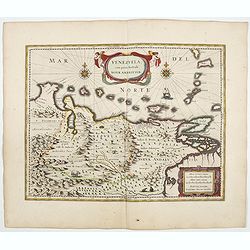
Venezuela cum parte Australi Novae Andalusiae.
A finely engraved, decorative map of Venezuela. The islands of Trinidad and Tobago, Margarita, Aruba and Curaçao are shown. Local animals are depicted, sheep, birds, mon...
- $1100 / ≈ €1029
Place & Date: Amsterdam, ca. 1644
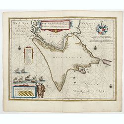
Tabula Magellanica.
A map with Willem Blaeu's signature, but published by his son Joan, of South America's extremity. A dedication to Constantijn Huygens. From early on Willem Jansz. Blaeu ...
- $1000 / ≈ €936
Place & Date: Amsterdam, 1644
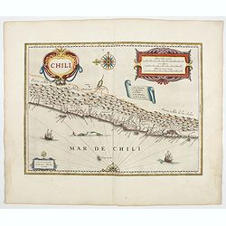
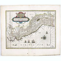
Chili.
Willem Blaeu's very decorative map of Chili with two large and beautiful cartouches, a compass and ships. From early on Willem Jansz. Blaeu aimed of publishing an atlas ...
- $900 / ≈ €842
Place & Date: Amsterdam, 1644
Peru.
FIRST EDITION, FIRST ISSUE OF THIS MAP. Decorated with ships and monsters in the sea. Orientated with east at the top. With the signature of G. Blaeuw lower right corner....
- $1000 / ≈ €936
Place & Date: Amsterdam, 1644

Nieuwe Wassende Graade Zee Kaart over de Spaanse Zee Vant Kanaal tot 't Eyland Cuba In Westindia.
Rare two-sheet blue-back sea chart of the Atlantic and Eastern part of North America., published by Gerard Van Keulen. The map extends from the latitude of Newfoundland a...
- $2000 / ≈ €1871
Place & Date: Amsterdam, ca. 1728-1751
Carte d'Amerique dressée par Pierre Tardieu. . .
Detailed map prepared by Pierre Tardieu. With good detail on Alaska. Including New Zealand.
- $450 / ≈ €421
Place & Date: Paris, 1831
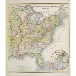
Die Vereinigten Staten von Nordamerika (Ostlicher theil).
Detailed map of eastern part of the United states. In lower right hand corner inset map of New York Bay, including, NY, Newark, Staten Island.The map is prepared by C.Gr�...
- $450 / ≈ €421
Place & Date: Weimar, 1874
Amérique..
Very detailed map from Atlas Sphéroïdal & Universel de géographie. Prepared by F.A.Garnier and edited by Jules Renouard, rue de Tournon, Paris. With decorative tit...
- $175 / ≈ €164
Place & Date: Paris, 1861
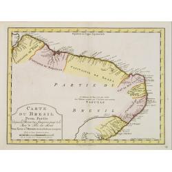
Carte du Bresil Prem.Partie...
Uncommon edition of this accurate map of the eastern part of Brazil.From Atlas Portatif pour servir a l'intelligence de l'Histoire Philosophique et Politique des etabliss...
- $100 / ≈ €94
Place & Date: Amsterdam, 1773
Stati Uniti d'America. Ridotta dalla Carta pubblicata a Nuova York du Colton.
Uncommon Italian map of the United States, Including Cuba, prepared by Cesare Maggi after Colton. Map is in outlined color.Many Indian names and settlements.From Geografi...
- $150 / ≈ €140
Place & Date: Turin, 1857
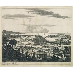
Portus Acapulco.
Attractive view of the city and harbor of Acapulco, showing fortifications, outlying buildings, ships in the harbor, costumed locals, etc.This map is taken from Ogilby's ...
- $300 / ≈ €281
Place & Date: London, 1671
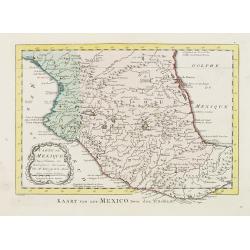
Carte du Mexique.
Uncommon edition of this fine map of Mexico. In lower right engraved 24.From Atlas Portatif pour servir a l'intelligence de l'Histoire Philosophique et Politique des etab...
- $75 / ≈ €70
Place & Date: Amsterdam, 1773
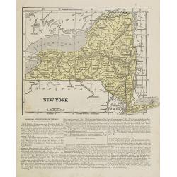
New York.
Map of New York. From Sidney E. Morse''s: System of Geography for the use of schools , published by Harper and brothers, 329 Pearl Street, New York.An 150 years old map w...
- $30 / ≈ €28
Place & Date: New York, 1855
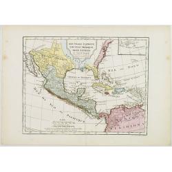
Nouvelle Espagne, Nouveau Méxique, Isles Antilles, par Robert de Vaugondy corrigés par le Cen. Lamarche Géog. Successeur de Vaugondy. l''An 3e.
Although dated 1794/95 [l'An 3e.], the map is a copy of an earlier map which appeared in Robert de Vaugondy's 1778 atlas. Hence, it does not show the newly independent Un...
- $300 / ≈ €281
Place & Date: Paris, 1794 - 1806
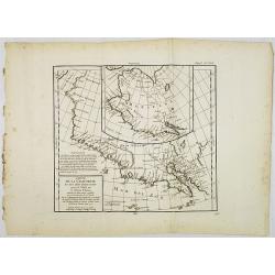
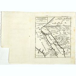
Carte de la Californie et des Pays Nord-Ouest. . . 4de Carte.
Diderot's famous 2 on 1 map shows the two early mappings of the west coast of North America, the first after Visscher, the second after Plancius' World map. Both show the...
- $200 / ≈ €187
Place & Date: Paris, 1779
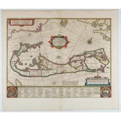
Mappa Aestivarum Insularum, alias Barmudas..
This magnificent map is based on the famous survey by John Norwood of the Bermuda Company in 1618. The map shows the division into the original Tribes and shows the vario...
- $2000 / ≈ €1871
Place & Date: Amsterdam, 1640
L'Amerique divisée en ses principaux Etats..
Uncommon map published by Lattré. This map is most notable for its depiction of "Mer de L'Ouest" or "Sea of the West". A great sea, easily the size o...
- $900 / ≈ €842
Place & Date: Paris, 1760
![Town of Hudson. . . [title in French, English, German & Latin] N°11. Pl. 3.](/uploads/cache/26653-250x250.jpg)
Town of Hudson. . . [title in French, English, German & Latin] N°11. Pl. 3.
The town of Hudson.From 3e Livraison Amérique Septentrionale - Etat de New York. After Jacques Milbert and lithographed by L. Sabatier, the figures by V. Adam. Printed b...
- $150 / ≈ €140
Place & Date: Paris, Bove dirigée par Nöel ainé & Cie, 1829
![Falls on the Flint River . . [title in French, English, German & Latin] N°33. Pl. 1.](/uploads/cache/26801-250x250.jpg)
Falls on the Flint River . . [title in French, English, German & Latin] N°33. Pl. 1.
A view of the Flint River Falls.From 9e Livraison Amérique Septentrionale - Etat de New York. After Jacques Milbert and lithographed by Deroy. Printed by E. Ardit, rue V...
- $150 / ≈ €140
Place & Date: Paris, Bove dirigée par Nöel ainé & Cie, 1829
![Noweav Mexiqve. [California as an Island]](/uploads/cache/26133-250x250.jpg)
Noweav Mexiqve. [California as an Island]
Scarce miniature map of California as a island, from Pierre Duval's La Geographie Universeille. The second earliest map to focus on just California and the contiguous coa...
- $800 / ≈ €749
Place & Date: Paris, 1672
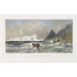
Débarquement sur les iles Powell, le 20 février 1838.
Exquisite contemporary colored lithograph of the Powell islands, situated near the South Orkney Islands, with Dumont D'Urville's officers leaving the island. Drawn by Lou...
- $400 / ≈ €374
Place & Date: Paris, 1848

Carte des parties Nord et est de l'Asie.. (5 maps on one sheet)
Five maps on one sheet, showing California, Alaska and Syberia, Korea and Japan. South to Korea the island "Quelpaerts".The map is from Diderot's "Encyclop...
- $200 / ≈ €187
Place & Date: Paris, 1772

Americae Nova Tabula.
The delineation of the coast and the nomenclature on both the Pacific and Atlantic coasts are basically Spanish in origin and follow the maps of Ortelius and Wytfliet. To...
- $7500 / ≈ €7018
Place & Date: Amsterdam, 1645

Portrait de Benjamin Franklin.
Portrait de Benjamin Franklin. From Giulio Ferrario's work Le Costume ancien et moderne ou histoire du gouvernement, de la milice, de la religion, des arts, etc. publishe...
- $75 / ≈ €70
Place & Date: Milan, 1827
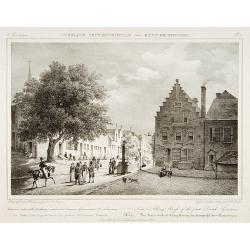
View in Albany-House of the first Dutch Governors.
Decorative print after Jacques Milbert, and lithographed by Tierpenne and the figures by Victor Adam.From Amérique Septentrionale. Printed by de Bove and Noöl ainé &am...
- $250 / ≈ €234
Place & Date: Paris, 1829
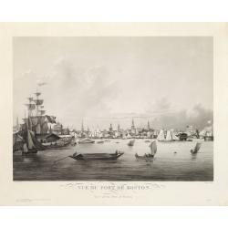
Vue du Port de Boston. View of the Port of Boston.
Superb aquatint of Boston harbor. Painted by L. Garneray and engraved by Himely. Published by Hocquart in Paris and Bailly Ward and Co. of New York.Second state with the...
- $2200 / ≈ €2059
Place & Date: Paris, ca. 1834
Die Vereinigten Staaten von Nord Amerika..
Uncommon map of the east coast of North America, including the Great Lakes area. To the right inset map of New Foundland. After the map by William Faden of 1783. With col...
- $500 / ≈ €468
Place & Date: Germany, 1790
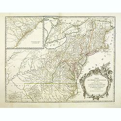
Partie De L'Amerique Septentrionale... Le Cours De L'Ohio, La N.lle Angleterre, a Nlle York, le New Jersey , La Pensyvanie, Le Maryland, Le Virginie, La Carolina...1755
From the Atlas Universel , a detailed map extending the length of the east coast from Penobscot Bay to Cape Fear and, in an inset, from Cape Fear to Fort St.Georges.This ...
- $750 / ≈ €702
Place & Date: Paris, 1768
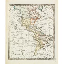
Amerika
Scarce miniature map of the Western Hemisphere.
- $200 / ≈ €187
Place & Date: Augsburg, 1824
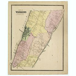
Town of Yonkers Westchester Co. NY
Fine lithographed map of the town of Yonkers. The map provides the names of specific homeowners, as well as information about the occupations and physical locations of th...
- $150 / ≈ €140
Place & Date: New York, 1867
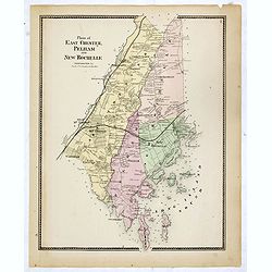
Plans of East Chester Pleham and New Rochelle. Westchester Co.
Fine lithographed map of East Chester Pelham and New Rochelle. The map provides the names of specific homeowners, as well as information about the occupations and physica...
- $100 / ≈ €94
Place & Date: New York, 1867
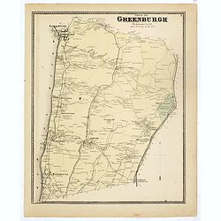
Town of Greenburgh.
Fine lithographed map of the town of Greenburgh. The map provides the names of specific homeowners, as well as information about the occupations and physical locations of...
- $100 / ≈ €94
Place & Date: New York, 1867
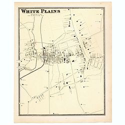
White Plains.
Fine lithographed map of White Plains. The map provides the names of specific homeowners, as well as information about the occupations and physical locations of the vario...
- $125 / ≈ €117
Place & Date: New York, 1867
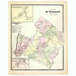
Town of Mt Pleasant. Westchester Co. NY.
Fine lithographed map of the town of Mt Pleasant. The map provides the names of specific homeowners, as well as information about the occupations and physical locations o...
- $100 / ≈ €94
Place & Date: New York, 1867
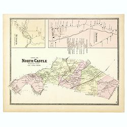
Town of North Castle.
Fine lithographed map of the town of North Castle. The map provides the names of specific homeowners, as well as information about the occupations and physical locations ...
- $100 / ≈ €94
Place & Date: New York, 1867
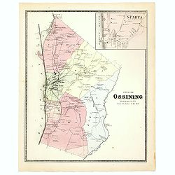
Town of Ossining. Westchester Co. NY.
Fine lithographed map of the town of Ossining. The map provides the names of specific homeowners, as well as information about the occupations and physical locations of t...
- $100 / ≈ €94
Place & Date: New York, 1867
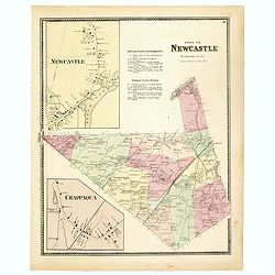
Town of New Castle. Westchester Co. NY.
Fine lithographed map of the town of New Castle. The map provides the names of specific homeowners, as well as information about the occupations and physical locations of...
- $100 / ≈ €94
Place & Date: New York, 1867
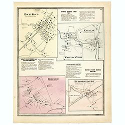
Mount Kisco / Bedford / Katonah / Bedford Station.
Fine lithographed map of Mount Kisco / Bedford / Katonah / Bedford Station. The map provides the names of specific homeowners, as well as information about the occupation...
- $100 / ≈ €94
Place & Date: New York, 1867
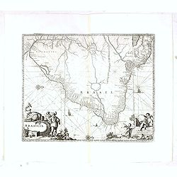
Brasilia.
Very fine decorative map od Brazil with west to the top. From the book "A Collection of Voyages and Travels" by Churchill and the map came from the part contain...
- $550 / ≈ €515
Place & Date: London, Printed for A. and J. Churchill, 1703
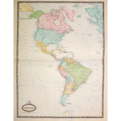
L'Amerique Septentrionale Divisee en Ses Principaux Etats. . .
Engraved by Lattré. This map is most notable for its depiction of Mer de L'Quest or Sea of the West, near modern-day Seattle. A great sea, easily the size of the Mediter...
- $500 / ≈ €468
Place & Date: Paris, 1782
![[American history plate].](/uploads/cache/40176-250x250.jpg)
[American history plate].
Scarce print (150x177mm.) on a German text sheet taken from a first edition of Johann Ludwig Gottfried's "Newe Welt Vnd Americanische Historien/ Jnhaltende Warhaffti...
- $80 / ≈ €75
Place & Date: Frankfurt, M.Merian, 1633
![[Murder of Dominican monks in Cumana or Cubagua Island].](/uploads/cache/40177-250x250.jpg)
[Murder of Dominican monks in Cumana or Cubagua Island].
Murder of Dominican monks in Cumana or Cubagua Island in what is now Venezuela. Scarce print (150x177mm.) on a German text sheet taken from a first edition of Johann Ludw...
- $80 / ≈ €75
Place & Date: Frankfurt, M.Merian, 1633
![[Moose].](/uploads/cache/40180-250x250.jpg)
[Moose].
Scarce print (150x177mm.) of a Moose on a German text sheet taken from a first edition of Johann Ludwig Gottfried's "Newe Welt Vnd Americanische Historien/ Jnhaltend...
- $100 / ≈ €94
Place & Date: Frankfurt, M.Merian, 1633
![[A Typical Tupi Feast.]](/uploads/cache/40065-250x250.jpg)
[A Typical Tupi Feast.]
Once a year the Indians from all the surrounding villages would get together for a feast. With decorative head-dresses, cloaks and belts of colored feathers, three or fou...
- $200 / ≈ €187
Place & Date: Frankfurt, M.Merian, 1633
![[Rituals for those that were dying.]](/uploads/cache/40066-250x250.jpg)
[Rituals for those that were dying.]
When one of the villagers was dying, the others would not feed or care for him but sing and danced as usual. Once he was dead though, the women would start lamenting by h...
- $200 / ≈ €187
Place & Date: Frankfurt, M.Merian, 1633
![[Staden forecasts an Indian attack.]](/uploads/cache/40067-250x250.jpg)
[Staden forecasts an Indian attack.]
Staden told the Indian chief that he could tell the future and, who lived in the nearby village of ‘Arirab’ (probably Cairussú). He predicted an attack from rival In...
- $150 / ≈ €140
Place & Date: Frankfurt, M.Merian, 1633
![[Indians attacked near Cartagena.]](/uploads/cache/40076-250x250.jpg)
[Indians attacked near Cartagena.]
When the governor of Cartagena, Alonso de Ojeda, led a party of Spanish soldiers into the interior to search for gold, they were attacked by Indians with such ferocity th...
- $125 / ≈ €117
Place & Date: Frankfurt, M.Merian, 1633
![[Indian market at Cartagena.]](/uploads/cache/40078-250x250.jpg)
[Indian market at Cartagena.]
The natives of the province of Cartagena had plenty of fruit, fish, salt and peppers, which they exchanged for other necessities of life. In times of peace, the natives o...
- $120 / ≈ €112
Place & Date: Frankfurt, M.Merian, 1633
![[How Incas wrought their gold.]](/uploads/cache/40080-250x250.jpg)
[How Incas wrought their gold.]
The goldsmiths of Huayna-Capac were master craftsmen who wrought gold into magnificent artefacts with the simplest of tools. They used clay furnaces, heated by coals and ...
- $200 / ≈ €187
Place & Date: Frankfurt, M.Merian, 1633
![[The ritual of the killing.]](/uploads/cache/40081-250x250.jpg)
[The ritual of the killing.]
On the day of the killing, the rope is untied from the prisoner’s neck, then put round his body and pulled tightly from both ends. A fire burns in front of the prisoner...
- $150 / ≈ €140
Place & Date: Frankfurt, M.Merian, 1633
![[Revenge for Juan de Ayola's death.]](/uploads/cache/40083-250x250.jpg)
[Revenge for Juan de Ayola's death.]
During Ayolas’s travels in Paraguay, he founded the fort at La Candelaria, near Corumba but later, while returning to Asunción, he and his entire party were killed by ...
- $120 / ≈ €112
Place & Date: Frankfurt, M.Merian, 1633
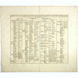
Division generale de l'Amerique dans ses principales parties pour l'intelligence de la carte de ce païs.
This folio sheet gives a breakdown of America into the northern and southern regions. These are further subdivided into the various countries and provinces.Henri Abraham ...
- $25 / ≈ €23
Place & Date: Amsterdam, 1728
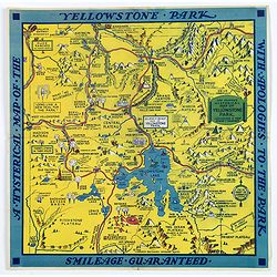
The Famous Hysterical Map of Yellowstone Park, including a few minor Changes.
A lovely whimsical map of America's Yellowstone Park, published about the time of President Franklin Roosevelt's "New Deal" for America in 1936. To emphasise th...
- $450 / ≈ €421
Place & Date: America, ca 1936
L'Amerique Meridionale Dressée sur les Observations . . .
Detailed map of South America prepared by De L'Isle, with fine title cartouche.
- $500 / ≈ €468
Place & Date: Amsterdam, ca. 1745

A Hysterical Map Of Death Valley National Monument -- And It's Looking Mighty Low
First edition Humorous map of Death Valley. "Drawn In Broken English by Jolly Lindgren," this comic pictorial map is full of puns and comic vignettes related to...
- $500 / ≈ €468
Place & Date: Spokane, Wash., Lindgren Brothers, 1948
Un Passaggio per Terra a California Scoperto dal P. Eusebio Francesco Kino Gesuita Fragli Anni 1698 et 1701.
The rare Italian edition of Father Eusebio Francisco Kino's seminal map, which definitively ended the myth of California as an Island, which appeared in Saggio delle tran...
- $1200 / ≈ €1123
Place & Date: Napples, 1731
![[United States map with Ottoman script.]](/uploads/cache/44314-250x250.jpg)
[United States map with Ottoman script.]
Postcard size map in Ottoman script showing the United States prepared by Mehmet EŞREF in a small atlas : عمومولاياةىشهانيىحاوىكوچكاطلاس [...
- $175 / ≈ €164
Place & Date: Istanbul, 1325 or 1909
![[Mexico map with Ottoman script]](/uploads/cache/44321-250x250.jpg)
[Mexico map with Ottoman script]
Postcard size map in Ottoman script showing Mexico, including Texas prepared by Mehmet EŞREF in a small atlas : عمومولاياةىشهانيىحاوىكوچكاطل...
- $150 / ≈ €140
Place & Date: Istanbul, 1325 or 1909
![[ North and South America with telegraph cables, with Ottoman script]](/uploads/cache/44330-250x250.jpg)
[ North and South America with telegraph cables, with Ottoman script]
Postcard size map showing North and South America with telegraph cables. The map is in Ottoman Arabic-script prepared by Mehmet EŞREF in a small atlas : عمومولا�...
- $190 / ≈ €178
Place & Date: Istanbul, 1325 or 1909
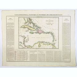
Carte Geographique, Statistique et Historique des Indes Occidentales.
A nice detailed map of The West Indies, including Cuba, the Bahamas, the southern most tip of FL, parts of Central America, and the northern tip of South America. From Bu...
- $120 / ≈ €112
Place & Date: Paris, 1825
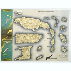
BWIA. North America - Caribbean Route Map.
An interesting double-sided brochure-type map of the routes flown by BWIA (British West Indian Airlines) between North America and the Caribbean. One side shows (not in t...
- $110 / ≈ €103
Place & Date: USA, ca 1960-1965
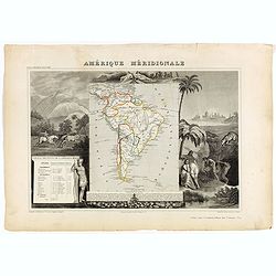
Amérique Méridionale.
Map of South America.Lovely map from one of the last decorative atlases of the nineteenth century.The rather simple map is framed by horses, Indians, jaguars, tapirs, and...
- $90 / ≈ €84
Place & Date: Paris, A. Combette, 1852
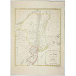
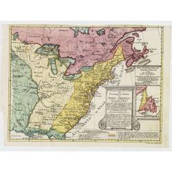
Mappa Geographica provinciae Nova.. NEW-YORK..
This map afforded British commanders during the Revolution an excellent overview of areas that would be crucial in the early years of the war, in particular the Hudson Va...
- $1500 / ≈ €1404
Place & Date: Nuremburg, 1778

Dutton Map of the Grand Canyon, Arizona (in 4 joined sheets)
An important 1882 map of the Grand Canyon, Arizona, published in "Atlas To Accompany The Monograph On The Tertiary History Of The Grand Canon District By Capt. Clare...
- $1000 / ≈ €936
Place & Date: Julius Bien & Co., 1882
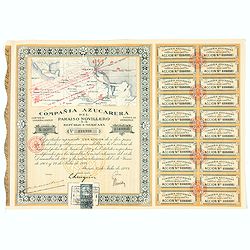
Accion de 10 pesos. No. 110,930 (Share certificate)
Beautifully engraved certificate from the "Compania Azucarera de Paraiso Novillero S.A. Republica Mexicana", share certificate No.110,930 for one share, in a $ ...
- $30 / ≈ €28
Place & Date: Paris, 1924

Dominia Anglorum in America Septentrionali.
Four maps on one sheet (New Found land/ New England/ Virginia and Carolina/Florida) based on J.B.Homann's map, showing British possessions in North America. At bottom of ...
- $1500 / ≈ €1404
Place & Date: Nuremberg 1740

Tartariae sive Magni Chami Imperium.
This is a very early depiction of the northern Pacific, with the first mapping of Northwest Coast of America and probably the first map to name California 'C. Califormio...
- $2500 / ≈ €2339
Place & Date: Antwerp, c. 1608-1612