Browse Listings in America
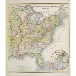
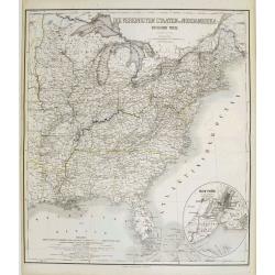
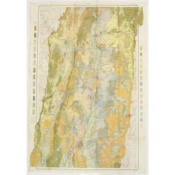
Die Vereinigten Staten von Nordamerika (Ostlicher theil).
Detailed map of eastern part of the United states. In lower right hand corner inset map of New York Bay, including, NY, Newark, Staten Island.The map is prepared by C.Gr�...
- $450 / ≈ €396
Place & Date: Weimar, 1874
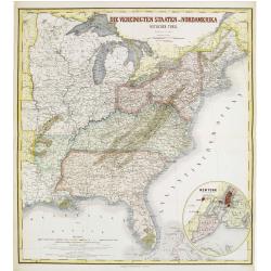
Die Vereinigten Staten von Nordamerika (Ostlicher theil).
Detailed map of eastern part of the United states until the border of Texas. In lower right hand corner inset map of New York Bay, including, NY, Newark, Staten Island.Th...
- $450 / ≈ €396
Place & Date: Weimar, 1874
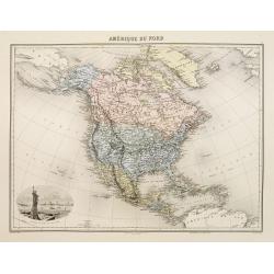
Amérique du Nord.
Decorative map of Northern America from Géographie Universelle, Atlas Migeon. published by J. Migeon. Nice engraving at the lower left hand of New York with the Statue o...
- $125 / ≈ €110
Place & Date: Paris, 1874
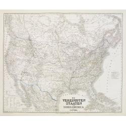
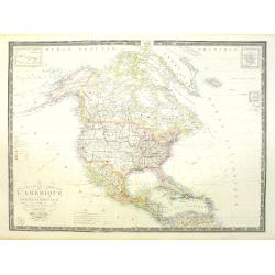
Die Vereinigten Staten von Nordamerika nebst Canada.
Large and very detailed German map issued prior to the outbreak of the Civil War. It covers the United States with parts of Canada and Mexico. The states and territories ...
- $400 / ≈ €352
Place & Date: Weimar, 1874
Nord America mit Westindien.
Detailed map of North America. With a color key indicating US, English, French, Dutch, Spanish, Portuguese, Danish possessions in the region with original outline color d...
- $300 / ≈ €264
Place & Date: Weimar, 1874
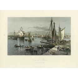
City of Boston.
A handsome mid 19th century panoramic view of the city of Boston as seen from the southern part of it's harbor. Many monuments are clearly visible, including the State Ho...
- $250 / ≈ €220
Place & Date: New York, 1872-1874
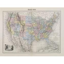
Etats-Unis.
Decorative map of the United States from Géographie Universelle, Atlas Migeon. Oklahoma is Indian Territory with Public Lands in the panhandle. With an engraving lower l...
- $75 / ≈ €66
Place & Date: Paris, 1874
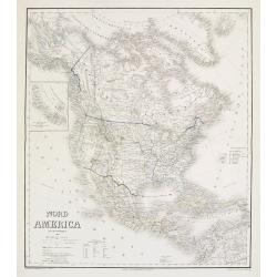
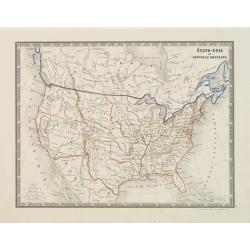
Nouvelle carte de l'Amérique Septentrionale et des iles qui en dépendent dressée par H. Brué. . .
Very large, highly detailed, and uncommon issue of the map of North and Central America (ca. 1:13,888,000) prepared by H. Brué and improved by A.Vuillemin. Showing main ...
- $500 / ≈ €440
Place & Date: Paris, 1875
Die Vereinigten Staaten von Nordamerika (Ostlicher theil).
This is a 1876 example of C. Graf's map of the United States of America. The map covers the eastern part of the United States from eastern Texas to the Atlantic, extendin...
- $300 / ≈ €264
Place & Date: Weimar, 1876
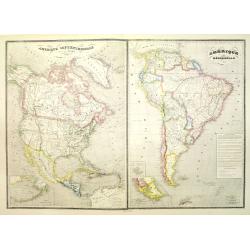
Amérique septentrionale dressée par C.V. Monin. . . / Amérique méridionale. . .
Two maps on one sheet. North America to the left, shows major cities, political divisions, and areas of Indian habitation for North America and the West Indies and state ...
- $300 / ≈ €264
Place & Date: Paris, c.1876
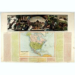
América del Norte.
Very attractive large map of North America with stunning panorama at top of figures representing the continents, etc. A rare and decorative map. From "Atlas geográf...
- $550 / ≈ €484
Place & Date: Madrid, 1877
États-Unis et Nouvelle Bretagne.
Detailed map of the United States. All different States are divided by an orange border line.
- $120 / ≈ €106
Place & Date: Paris, 1880

Dutton Map of the Grand Canyon, Arizona (in 4 joined sheets)
An important 1882 map of the Grand Canyon, Arizona, published in "Atlas To Accompany The Monograph On The Tertiary History Of The Grand Canon District By Capt. Clare...
- $1000 / ≈ €880
Place & Date: Julius Bien & Co., 1882
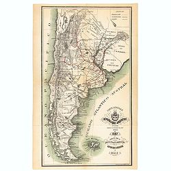
Carte générale de la République Argentine dressée d'après les données les plus récentes.
An UpToDate map of the Argentinian Republic published in Basel by "le Bureau Officiel d'Information de la République Argentine". Detailed map of Argentina show...
- $350 / ≈ €308
Place & Date: Basel, 1887
Etats Unis (Etats de l' Ouest).
Large format highly detailed map of the states and territories of the West, with Central America, included in a large inset titled "Etats de l'Amerique Centrale"...
- $400 / ≈ €352
Place & Date: Paris, 1889
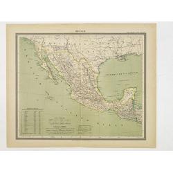
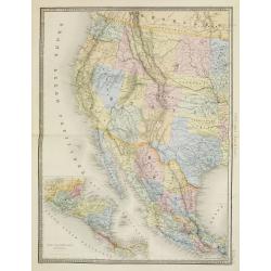
Mexico.
Decorative territorial map showing the Southwest of the United States with Mexico, Baja California and the neighboring states Arizona, New Mexico and Texas. The map exten...
- $200 / ≈ €176
Place & Date: Glogau, 1892

Map showing the cotton growing belt in the United States Prepared for and copyrighted by Geo. H.Mc.Fadden & Bro., cotton merchands based in Phiiladelphia, USA 1892.
A rare map showing the cotton-growing Belts in the Southern States for 1892. Prepared for and copyrighted by Geo. H. Mc.Fadden & Bro., cotton merchants based in Phila...
- $1000 / ≈ €880
Place & Date: Philadelphia, 1892
![[South America].](/uploads/cache/46140-250x250.jpg)
[South America].
Alexey Afinogenovich Ilyin was a lieutenant general and cartographer (1832-1889). In 1856, after graduating from the Academy of the General Staff, he was at the military ...
- $100 / ≈ €88
Place & Date: St. Petersburg, 1899
![[North America].](/uploads/cache/46142-250x250.jpg)
[North America].
Alexey Afinogenovich Ilyin was a lieutenant general and cartographer (1832-1889). In 1856, after graduating from the Academy of the General Staff, he was at the military ...
- $150 / ≈ €132
Place & Date: St. Petersburg, 1899
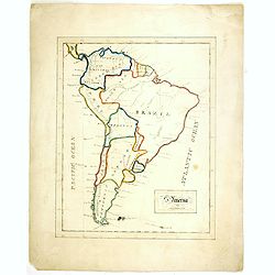
S America by Mas T.J. Sackels.
Pen and ink on card board. Map of South America drawn by T.J.Shackels. Probably a school exercise.
- $120 / ≈ €106
Place & Date: England, ca. 1900
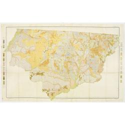
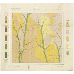
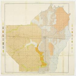
Soil map - Florida, Gadsden County sheet.
Early color lithographed soil map by Julius Bien & Co. in New York for the Department of Agriculture. Legends at the side give detail on soil type, etc. They also inc...
- $40 / ≈ €35
Place & Date: New York, 1903
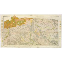
Soil map - South Carolina Campobello Sheet.
Early color lithographed soil map by Julius Bien & Co. in New York for the Department of Agriculture. Legends at the side give detail on soil type, etc. They also inc...
- $50 / ≈ €44
Place & Date: New York, 1903
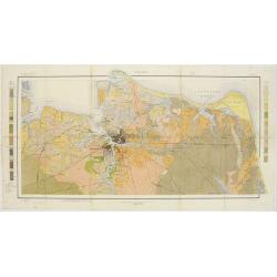
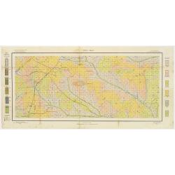
Soil map - Virginia Norfolk Sheet.
Soil map printed by Julius Bien & Co. in New York for the Department of Agriculture. The map gives great detail of the area centered on Norfolk, Potsmouth, Chesapeake...
- $50 / ≈ €44
Place & Date: New York 1903
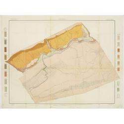
Soil map - Pennsylvania, Lockhaven sheet.
Early color lithographed soil map by Julius Bien & Co. in New York for Department of Agriculture. Legends at side give detail on soil type, etc. They also include int...
- $50 / ≈ €44
Place & Date: New York, 1903
Soil map - Connecticut. - Massachusetts, (Hartford) Springfield sheet.
Early color lithographed soil map by Julius Bien & Co. in New York for Department of Agriculture. Legends at side give detail on soil type, etc. They also include int...
Place & Date: New York, 1903
Selling price: $85
Sold in 2008
Soil map - Texas, Nacogdoches sheet.
Early color lithographed soil map by Julius Bien & Co. in New York for Department of Agriculture. Legends at side give detail on soil type, etc. They also include int...
- $75 / ≈ €66
Place & Date: New York, 1903
Soil map - Georgia, Fort Valley sheet.
Early color lithographed soil map by Julius Bien & Co. in New York for Department of Agriculture. Legends at side give detail on soil type, etc. They also include in...
- $50 / ≈ €44
Place & Date: New York, 1903
Soil map - Mississippi, McNeill sheet.
Soil map printed by Julius Bien & Co in New York for Department of Agriculture. The map is giving great detail of the area McNeill, Mississippi, in the year 1903. Soi...
- $50 / ≈ €44
Place & Date: New York, 1903
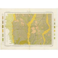
Soil map - Louisiana, Ouachita sheet.
Early color lithographed soil map by Julius Bien & Co. in New York for Department of Agriculture. Legends at side give detail on soil type, etc. They also include int...
- $40 / ≈ €35
Place & Date: New York, 1903
![[United States map with Ottoman script.]](/uploads/cache/44314-250x250.jpg)
[United States map with Ottoman script.]
Postcard size map in Ottoman script showing the United States prepared by Mehmet EŞREF in a small atlas : عمومولاياةىشهانيىحاوىكوچكاطلاس [...
- $175 / ≈ €154
Place & Date: Istanbul, 1325 or 1909
![[Mexico map with Ottoman script]](/uploads/cache/44321-250x250.jpg)
[Mexico map with Ottoman script]
Postcard size map in Ottoman script showing Mexico, including Texas prepared by Mehmet EŞREF in a small atlas : عمومولاياةىشهانيىحاوىكوچكاطل...
- $150 / ≈ €132
Place & Date: Istanbul, 1325 or 1909
![[ North and South America with telegraph cables, with Ottoman script]](/uploads/cache/44330-250x250.jpg)
[ North and South America with telegraph cables, with Ottoman script]
Postcard size map showing North and South America with telegraph cables. The map is in Ottoman Arabic-script prepared by Mehmet EŞREF in a small atlas : عمومولا�...
- $190 / ≈ €167
Place & Date: Istanbul, 1325 or 1909
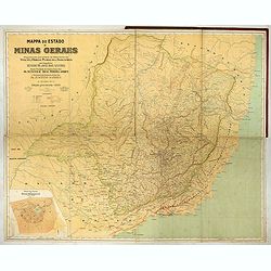
Mappa do estado de Minas Geraes.
Monumental map of the Minas Geraes State, the Brazilian Eldorado, with an inset plan of Belo Horizonte. Scale of 1 : 100 000. Lith. Hartmann-Reichenbach, 1910. Organized ...
- $1000 / ≈ €880
Place & Date: Rio de Janeiro, 1910 -1911
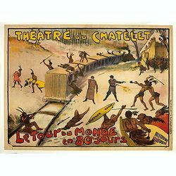
Théâtre du Châtelet. Le Tour du Monde en 80 jours. (The attack of the train).
Theatre poster for "Around the World in Eighty Days by A. Dennery and Jules Verne, for Théâtre du Châtelet, Paris. Printed by : Imprimerie Ch. Wall et Cie, 14 rue...
- $1200 / ≈ €1057
Place & Date: Paris, Imp. Ch. Wall et Cie, ca.1900-1914
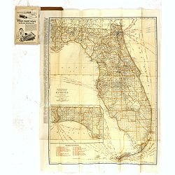
Rand Mc.Nally indexed pocket map Tourits' and Shipper' Guide of Florida. . .
This fine pocket map has on both side a map of Florida. Folding color map (approximately 640 x 495mm) is titled "Rand McNally standard map of Florida" and one h...
Place & Date: Chicago & New York, ca.1915
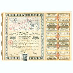
Accion de 10 pesos. No. 110,930 (Share certificate)
Beautifully engraved certificate from the "Compania Azucarera de Paraiso Novillero S.A. Republica Mexicana", share certificate No.110,930 for one share, in a $ ...
- $30 / ≈ €26
Place & Date: Paris, 1924
![[Map of the Monterey Peninsula.]](/uploads/cache/48349-250x250.jpg)
[Map of the Monterey Peninsula.]
A lovely example of Jo Mora's Del Monte Properties Company' California's Fun' playground tourist map of the Monterey Peninsular, published in San Francisco in 1927. The r...
- $900 / ≈ €792
Place & Date: San Francisco, 1927

Cidade do Rio de Janeiro - Remodelação, Extensão e Embelezamento.
Important architectural book prepared by Antonio Prado Junior (1880-1955) under the general direction of Alfredo Agache ( 1875-1959) published by Foyer Brésilien editor,...
- $1100 / ≈ €969
Place & Date: Foyer Brésilien editor, Paris, 1930
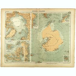
Régions Polaires.
Eight maps on one sheet, showing the North and South Poles, with adjective regions. Taken from "Atlas Universel" by Chesneau and Ch. Bonnesseur. Engraved by R. ...
- $50 / ≈ €44
Place & Date: Paris, 1931
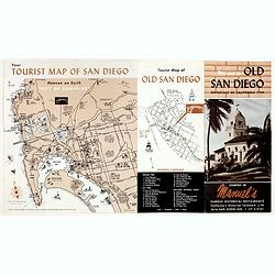
Welcome to old San Diego, birthplace of California 1769.
Publicity leaflet for "Manuel's Restauranté" in the Casa de Pedrorena. On one side a pictorial map of San Diego and "Tourist Map of Old San Diego", w...
- $75 / ≈ €66
Place & Date: San Diego, ca. 1935
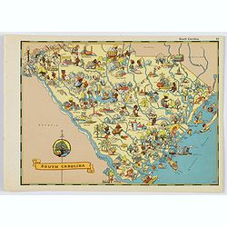
South Carolina.
A fun, humorous, whimsical map of South Carolina by Ruth Taylor White. With vibrant colors.The state is filled with delightful cartoonish characters, some pursuing assort...
- $125 / ≈ €110
Place & Date: Boston, ca 1935
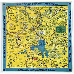
The Famous Hysterical Map of Yellowstone Park, including a few minor Changes.
A lovely whimsical map of America's Yellowstone Park, published about the time of President Franklin Roosevelt's "New Deal" for America in 1936. To emphasise th...
- $450 / ≈ €396
Place & Date: America, ca 1936
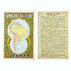
America del Sur Filatelica.
Unique manuscript map of South America. Award-winning manuscript card, prepared by Antonio Raggio for the 11th Congreso de la Union Postal Universal (World Postal Congres...
Place & Date: Buenos Aires, 1939
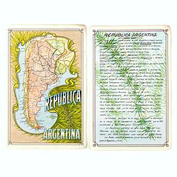
Republica Argentina.
Unique manuscript map of Argentina. Award-winning manuscript card, prepared by Antonio Raggio for the 11th Congreso de la Union Postal Universal (World Postal Congress) E...
Place & Date: Buenos Aires, 1939
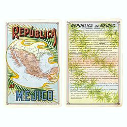
Republica Mejico
Unique manuscript map of Mexico. Award-winning manuscript card, prepared by Antonio Raggio for the 11th Congreso de la Union Postal Universal (World Postal Congress) Expo...
- $200 / ≈ €176
Place & Date: Buenos Aires, 1939
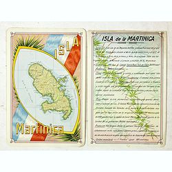
Isla Martinica.
A beautiful hand colored, hand drawn map of the French Caribbean island of Martinique, prepared for the Buenos Aires 1939 Philatelic Exhibition, with separate text with d...
- $100 / ≈ €88
Place & Date: Buenos Aires, 1939
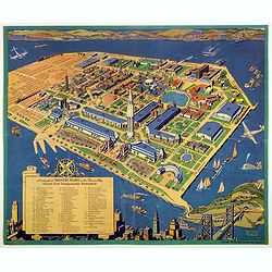
A cartograph of Treasure Island in San Francisco Bay Golden Gate International Exposition.
Ruth Taylor White's large format map of Treasure Island and the San Francisco Golden Gate Exposition Fairgrounds, published in 1940.The map provides an aerial panorama of...
- $200 / ≈ €176
Place & Date: San Francisco, 1940

The Greyhound Map of This Amazing America. . .
A large colored lithograph map of the USA, published by the Greyhound Corporation during the second world war. The map demonstrates where all the Greyhound bus routes int...
- $150 / ≈ €132
Place & Date: United States, 1941

Alabama. Official Highway map 1942.
Folding road map of Alabama. Published in Montgomery, Alabama by Paragon Press. Mileage chart and six city plans in margin; verso includes text and photos. Scale [ca. 1:8...
- $100 / ≈ €88
Place & Date: Alabama, Paragon Press, 1942

A Hysterical Map Of Death Valley National Monument -- And It's Looking Mighty Low
First edition Humorous map of Death Valley. "Drawn In Broken English by Jolly Lindgren," this comic pictorial map is full of puns and comic vignettes related to...
- $500 / ≈ €440
Place & Date: Spokane, Wash., Lindgren Brothers, 1948
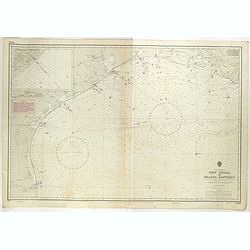
Gulf of Mexico. Ship Shoal to Brazos Santiago.
A large sea chart of the Gulf of Mexico, Ship Shoal to Brazos Santiago, 'from Admiralty Charts and US Government charts, corrected to 1943'. (In fact there are correction...
- $200 / ≈ €176
Place & Date: London, 1943 updated to 1951
![[Set of 2 maps] The Pageant of History in Northern California its colorful and adventuresome beginnings / The Panorama of Today in Northern California its resources, activities and opportunities.](/uploads/cache/48343A-250x250.jpg)
[Set of 2 maps] The Pageant of History in Northern California its colorful and adventuresome beginnings / The Panorama of Today in Northern California its resources, activities and opportunities.
An unusual and attractive pair of lithographed maps, issued by the American Trust Company, in San Francisco on the occasion of its centenary in 1954. It chose to do this ...
- $350 / ≈ €308
Place & Date: San Francisco, 1954
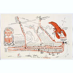
Map of Atlantic City to Hackney's Famous Garden of Sea Food . . .
A mid 1950s brochure for the famous Atlantic City Seafood Restaurant - 'Hackneys'. One side proclaims that "All Roads lead to Hackney's". It shows a nice plan o...
- $50 / ≈ €44
Place & Date: New Jersey, ca 1954
![[In Arabic, translates : A map of the United States of America shows its major regional ressources and its natural products]](/uploads/cache/43010-250x250.jpg)
[In Arabic, translates : A map of the United States of America shows its major regional ressources and its natural products]
Chromolithographed pictorial poster of the United States in Arabic language. Showing the United States' main products, regional resources and physical features. The map i...
Place & Date: Washington D.C., ca. 1965
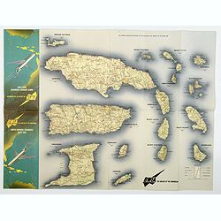
BWIA. North America - Caribbean Route Map.
An interesting double-sided brochure-type map of the routes flown by BWIA (British West Indian Airlines) between North America and the Caribbean. One side shows (not in t...
- $110 / ≈ €97
Place & Date: USA, ca 1960-1965
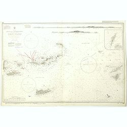
West Indies Virgin islands Sheet III Tortola I. to Culebra including St. Thomas...
An British Admiralty chart of the Virgin Islands. A highly corrected version of Admiralty chart 2452 originally published 15th December 1856 under the Superintendence of ...
- $135 / ≈ €119
Place & Date: London, 1856- 1988-1993
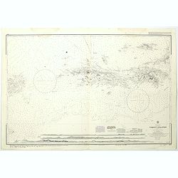
West Indies Anguilla to Puerto Rico showing the approaches to the Virgin Islands . . .
A highly corrected version of Admiralty chart 130 originally published 22nd June 1868 under the Superintendence of Captain G.H. Richards. Edition Date 1974 with further c...
- $100 / ≈ €88
Place & Date: London, 1868 - 1999